4.0 Responding to the Design Issues of Rosebud - Mornington ...
4.0 Responding to the Design Issues of Rosebud - Mornington ...
4.0 Responding to the Design Issues of Rosebud - Mornington ...

You also want an ePaper? Increase the reach of your titles
YUMPU automatically turns print PDFs into web optimized ePapers that Google loves.
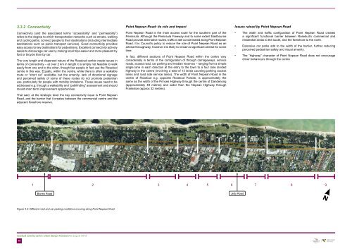
3.3.2 Connectivity<br />
Connectivity (and <strong>the</strong> associated terms “accessibility” and “permeability”)<br />
refers <strong>to</strong> <strong>the</strong> degree <strong>to</strong> which transportation networks such as streets, walking<br />
and cycling paths, connect people <strong>to</strong> <strong>the</strong>ir destinations (including intermediate<br />
destinations such as public transport services). Good connectivity provides<br />
easy access <strong>to</strong> key destinations for pedestrians. Excellent connectivity actively<br />
seeks <strong>to</strong> discourage car use by making local trips easier and more pleasant by<br />
foot or bicycle than by car.<br />
The very length and dispersed nature <strong>of</strong> <strong>the</strong> <strong>Rosebud</strong> centre create issues in<br />
terms <strong>of</strong> connectivity – at over 2 km in length it is simply not feasible <strong>to</strong> walk<br />
easily from one end <strong>to</strong> <strong>the</strong> o<strong>the</strong>r, though few people in fact use <strong>the</strong> <strong>Rosebud</strong><br />
centre in this way. Equally, within <strong>the</strong> centre, while <strong>the</strong>re is <strong>of</strong>ten a walkable<br />
route or “short cut” available, but <strong>the</strong> amenity, lack <strong>of</strong> directional 3 signage<br />
and perceived safety <strong>of</strong> some <strong>of</strong> <strong>the</strong>se routes do not promote pedestrian<br />
use, particularly for people with mobility limitations. These issues need <strong>to</strong> be<br />
addressed e.g. through a walkability and “pathfinding” assessment and should<br />
mould short term improvement opportunities.<br />
That said, at <strong>the</strong> strategic level <strong>the</strong> key connectivity issue is Point Nepean<br />
Road, and <strong>the</strong> barrier that it creates between <strong>the</strong> commercial centre and <strong>the</strong><br />
adjacent foreshore reserve.<br />
rosebud activity centre urban design framework | august 2012<br />
10<br />
Point Nepean Road: its role and impact<br />
Point Nepean Road is <strong>the</strong> main access route for <strong>the</strong> sou<strong>the</strong>rn part <strong>of</strong> <strong>the</strong><br />
Peninsula. Although <strong>the</strong> Peninsula Freeway and <strong>to</strong> some extent Eastbourne<br />
Road provide alternative routes, traffic is still concentrated along Point Nepean<br />
Road. It is Council’s policy <strong>to</strong> reduce <strong>the</strong> role <strong>of</strong> Point Nepean Road as an<br />
arterial throughway; however it is likely <strong>to</strong> remain a significant arterial for some<br />
time.<br />
In fact, different sections <strong>of</strong> Point Nepean Road within <strong>the</strong> centre vary<br />
considerably in terms <strong>of</strong> <strong>the</strong> configuration <strong>of</strong> through carriageways, service<br />
roads, access road, car parking and median reserves – ranging from a simple<br />
single lane in each direction at <strong>the</strong> entry <strong>to</strong> <strong>the</strong> <strong>to</strong>wn <strong>to</strong> a four lane divided<br />
highway in <strong>the</strong> centre (involving a <strong>to</strong>tal <strong>of</strong> 13 lanes counting parking access<br />
lanes and road side service lanes). The width <strong>of</strong> Point Nepean Road in <strong>the</strong><br />
centre <strong>of</strong> <strong>Rosebud</strong> e.g. opposite <strong>Rosebud</strong> Parade, is approximately <strong>the</strong><br />
same as <strong>the</strong> width <strong>of</strong> <strong>the</strong> Princes Highway through <strong>the</strong> centre 2 <strong>of</strong> Dandenong<br />
(approximately 49 metres) and wider than <strong>the</strong> Nepean Highway through<br />
Franks<strong>to</strong>n (approx 32 metres).<br />
<strong>Issues</strong> raised by Point Nepean Road<br />
• The width and traffic configuration <strong>of</strong> Point Nepean Road creates<br />
a significant functional barrier between <strong>Rosebud</strong>’s commercial and<br />
residential areas <strong>to</strong> <strong>the</strong> south, and <strong>the</strong> foreshore <strong>to</strong> <strong>the</strong> north.<br />
• Extensive car parks add <strong>to</strong> <strong>the</strong> width <strong>of</strong> <strong>the</strong> barrier, fur<strong>the</strong>r reducing<br />
perceived pedestrian safety and visual amenity.<br />
• The “highway” character <strong>of</strong> Point Nepean Road does not encourage<br />
driver behaviours through <strong>the</strong> centre<br />
1 2 3 4 5 6 7 8 9<br />
Boneo Road Jetty Road<br />
Figure 3.4: Different road and car parking conditions occuring along Point Nepean Road<br />
1<br />
N
1<br />
Section 1<br />
Two-lane undivided road with on-street car parking along<br />
sou<strong>the</strong>rn edge <strong>of</strong> road reserve<br />
Figure 3.5: Different sections <strong>of</strong> Point Nepean Road<br />
Section 2<br />
Four-lane divided road with narrow median landscape strip, and on-street<br />
car parking<br />
N<br />
Point Nepean Road<br />
Public Car Parking<br />
rosebud activity centre urban design framework | august 2012<br />
11
osebud activity centre urban design framework | august 2012<br />
12<br />
Section 3<br />
Four-lane divided road with median car parking separated from<br />
carriageway by grassed verge, and on-street car parking<br />
Figure 3.6: Different sections <strong>of</strong> Point Nepean Road<br />
Section 4<br />
Four-lane divided road with narrow median<br />
landscape strip, angle car parking along<br />
sou<strong>the</strong>rn edge <strong>of</strong> road reserve separated from<br />
carriageway by grassed verge, and on-street car<br />
parking along nor<strong>the</strong>rn edge <strong>of</strong> road reserve<br />
Section 5<br />
Four-lane divided road with narrow median<br />
landscape strip; a service road along sou<strong>the</strong>rn<br />
edge <strong>of</strong> road reserve with indented car parking;<br />
angle car parking lots between service lane and<br />
main carriageway; and on-street car parking along<br />
nor<strong>the</strong>rn edge <strong>of</strong> road reserve<br />
Section 6<br />
Four-lane divided road with wide median landscape strip which narrows<br />
<strong>to</strong> <strong>the</strong> west, <strong>to</strong> accommodate a service road with indented & angle car<br />
parking along sou<strong>the</strong>rn edge <strong>of</strong> road reserve, and on-street car parking<br />
along nor<strong>the</strong>rn edge <strong>of</strong> road reserve<br />
N<br />
Point Nepean Road<br />
Public Car Parking
Section 7<br />
Four-lane divided road with median car parking,<br />
separated from carriageway by grassed verge, and<br />
on-street car parking<br />
Figure 3.7: Different sections <strong>of</strong> Point Nepean Road<br />
Section 8<br />
Four-lane divided road with wide median landscape strip, and on-street car parking<br />
Section 9<br />
Two-lane undivided road<br />
N<br />
Point Nepean Road<br />
Public Car Parking<br />
rosebud activity centre urban design framework | august 2012<br />
13
3.3.3 Place Quality<br />
a. Place quality and <strong>the</strong> lack <strong>of</strong> a strong and consistent identity<br />
and image<br />
Place Quality is something <strong>of</strong> a catch-all term, covering a range <strong>of</strong> considerations<br />
which are also referred <strong>to</strong> by words such as liveability, amenity, vitality and<br />
sustainability. The elements which affect place quality range from <strong>the</strong> width<br />
<strong>of</strong> footpaths <strong>to</strong> <strong>the</strong> way in which buildings create a sense <strong>of</strong> enclosure and<br />
<strong>the</strong> psychological dimension <strong>of</strong> a defined space. The related notion <strong>of</strong> “place<br />
making” has also been prominent, and perhaps highlights <strong>the</strong> limitations <strong>of</strong> <strong>the</strong><br />
“helicopter view” <strong>of</strong> traditional plans – <strong>the</strong> coloured zones and connecting lines<br />
may look logical on a plan but may have much less meaning at ground level.<br />
Place making requires much direct engagement with <strong>the</strong> living and social<br />
experience <strong>of</strong> places – and <strong>the</strong> need for <strong>the</strong> involvement <strong>of</strong> <strong>the</strong> users in <strong>the</strong><br />
design <strong>of</strong> such places.<br />
It is important <strong>to</strong> recognise that <strong>the</strong> RACUDF does not provide highly detailed<br />
plans for <strong>the</strong> design <strong>of</strong> places but ra<strong>the</strong>r works at a more general level, providing<br />
overall directions that hopefully will inform future place making processes.<br />
<strong>Issues</strong> relating <strong>to</strong> Place Quality<br />
rosebud activity centre urban design framework | august 2012<br />
14<br />
• Uncoordinated strip development has resulted in parts <strong>of</strong> <strong>the</strong> centre<br />
having a visually ‘noisy’ environment with low-grade pedestrian amenity<br />
and civic landscape. The streetscape has a high degree <strong>of</strong> repetition,<br />
and a lack <strong>of</strong> landmarks reduces urban imageability. <strong>Rosebud</strong> has not<br />
developed a strong and consistent landscape <strong>the</strong>me along <strong>the</strong> main<br />
activity spine and <strong>the</strong>re are no major landmarks <strong>to</strong> define <strong>the</strong> <strong>Rosebud</strong><br />
<strong>to</strong>wn centre and distinguish it from o<strong>the</strong>r <strong>to</strong>wns along Point Nepean<br />
Road.<br />
• The single-sided nature <strong>of</strong> <strong>the</strong> <strong>Rosebud</strong> centre, although providing a<br />
nor<strong>the</strong>rn orientation <strong>to</strong> <strong>the</strong> shop fronts, presents challenges in terms <strong>of</strong><br />
achieving <strong>the</strong> quality <strong>of</strong> enclosure which is frequently associated with<br />
a positive “urban” character and “street life”. This issue is compounded<br />
by <strong>the</strong> lack <strong>of</strong> street frontage in a number <strong>of</strong> sections <strong>of</strong> <strong>the</strong> centre,<br />
notably <strong>to</strong>wards Boneo Road, and <strong>the</strong> free-standing fast food outlets.<br />
There are also a number <strong>of</strong> sites where large parking areas are located<br />
on <strong>the</strong> road frontage.<br />
• Point Nepean Road itself is a dominant visual as well as functional<br />
presence, compounded by <strong>the</strong> additional areas dedicated <strong>to</strong> parking<br />
and service lanes.<br />
• The commercial areas behind <strong>the</strong> Point Nepean Road strip are <strong>of</strong>ten<br />
underutilised and <strong>the</strong>re is a need <strong>to</strong> manage <strong>the</strong> residential-commercial<br />
interface.<br />
• The area between First Avenue and Ninth Avenue particularly<br />
seems <strong>to</strong> lack a identity as part <strong>of</strong> <strong>the</strong> centre and ad-hoc commercial<br />
development currently occupies land with high residential potential<br />
due <strong>to</strong> its bay frontage.<br />
• <strong>Rosebud</strong> is primarily a single s<strong>to</strong>rey centre and, while <strong>the</strong>re are local<br />
landmarks such as <strong>the</strong> hotel and memorial hall, <strong>the</strong>se are not visually<br />
prominent. An advantage <strong>of</strong> <strong>the</strong> low pr<strong>of</strong>ile <strong>of</strong> existing development<br />
is that <strong>the</strong> natural backdrop <strong>of</strong> Arthurs Seat is visually apparent from<br />
most areas within <strong>the</strong> centre. However, <strong>the</strong>re does appear <strong>to</strong> be<br />
scope for some use <strong>of</strong> height, both <strong>to</strong> create visual interest and <strong>to</strong><br />
facilitate development with views across <strong>to</strong> <strong>the</strong> Bay. The identification<br />
<strong>of</strong> areas where taller buildings may be appropriate is addressed in<br />
<strong>the</strong> Draft Structure Plan report. It would be important <strong>to</strong> ensure that<br />
taller buildings have active street edges and elevations on all sides<br />
(such as in podium style development) <strong>to</strong> avoid long periods where<br />
tall buildings with blank side walls are obtrusive elements in <strong>the</strong><br />
<strong>to</strong>wnscape. It is noted that <strong>the</strong> economic analysis provided by Charter<br />
Keck Cramer does not indicate strong market demand for increased<br />
building heights; this is a matter <strong>of</strong> preferred character ra<strong>the</strong>r than a<br />
need <strong>to</strong> meet demand for commercial space per se.<br />
• To <strong>the</strong> extent that <strong>the</strong> existing built form <strong>of</strong> <strong>Rosebud</strong> is unremarkable<br />
it is arguable that <strong>the</strong> most distinctive character element <strong>of</strong> <strong>the</strong> centre<br />
is <strong>the</strong> landscape setting, both in terms <strong>of</strong> foreshore and <strong>of</strong> vegetation<br />
within <strong>the</strong> road reserve, and in some places adjacent <strong>to</strong> <strong>the</strong> footpath.<br />
This could be a significant strength and a well coordinated streetscape/<br />
landscape plan, and “greening” <strong>of</strong> streets could provide for substantial<br />
increases in amenity <strong>of</strong> <strong>the</strong> centre, and shade in summer, provided<br />
<strong>the</strong>re is also careful consideration <strong>of</strong> viewlines and practical structural<br />
and maintenance issues. Landscape design, along with pavements,<br />
street furniture and signage make up <strong>the</strong> detailed level <strong>of</strong> design that<br />
needs <strong>to</strong> support <strong>the</strong> “big picture”. The establishment <strong>of</strong> a consistent<br />
signage policy and standard <strong>of</strong> street furniture, lighting, etc. would,<br />
over time, bring some level <strong>of</strong> coherence <strong>to</strong> <strong>the</strong> public realm.<br />
• The development <strong>of</strong> a strong public art strategy could also help <strong>to</strong><br />
differentiate <strong>Rosebud</strong> from o<strong>the</strong>r destinations along <strong>the</strong> coast.
. <strong>Rosebud</strong> Foreshore – its role, environmental and landscape<br />
quality, and connectivity<br />
Since <strong>the</strong> early 20th century, <strong>the</strong> foreshore has been a popular area for summer<br />
holiday campers from metropolitan Melbourne. The <strong>Rosebud</strong> foreshore is<br />
arguably <strong>the</strong> most iconic feature <strong>of</strong> <strong>Rosebud</strong> with its long beach, dunes and<br />
ti-tree vegetation. Toge<strong>the</strong>r with plantings <strong>of</strong> lambertiana pines and eucalypts,<br />
<strong>the</strong>se elements combine <strong>to</strong> form a linear park-like space almost 2 km long<br />
and 120 metres wide. Hence, between <strong>the</strong> beach and <strong>the</strong> busy highway, <strong>the</strong><br />
foreshore provides an area <strong>of</strong> more than 24 hectares <strong>of</strong> essentially public<br />
open space.<br />
The foreshore reserve also houses important community based recreational<br />
facilities including <strong>the</strong> Village Green, <strong>the</strong> Memorial Hall, Sound Shell, Rotary<br />
Park, <strong>the</strong> <strong>Rosebud</strong> Bowling Club, <strong>Rosebud</strong> Yacht Club and Mo<strong>to</strong>r Boat<br />
Squadron, <strong>Rosebud</strong> Carnival Park and <strong>the</strong> sea scouts. The foreshore has<br />
served as <strong>the</strong> main informal recreation focus for <strong>the</strong> <strong>Rosebud</strong> community,<br />
in part <strong>of</strong>fsetting <strong>the</strong> lack <strong>of</strong> alternative public open space reserves, while<br />
sporting activities are now more generally accommodated at <strong>the</strong> Olympic<br />
Park, <strong>of</strong>f Besgrove Street.<br />
Parts <strong>of</strong> <strong>the</strong> business sec<strong>to</strong>r see <strong>the</strong> foreshore as under-utilised and an<br />
opportunity for development. However, much <strong>of</strong> <strong>the</strong> community is reserved<br />
about development, emphasising limited development or none at all due <strong>to</strong><br />
environmental concerns.<br />
There is also a current proposal <strong>to</strong> develop a major aquatic centre on <strong>the</strong><br />
foreshore: <strong>the</strong> Sou<strong>the</strong>rn Peninsula Aquatic Centre (SPA), although siting and<br />
design options are still being evaluated.<br />
In addition, <strong>the</strong>re is a tract <strong>of</strong> residential zoned land on <strong>the</strong> foreshore side <strong>of</strong><br />
Point Nepean Road, generally opposite Adams Avenue and Ninth Avenue.<br />
This subdivision is his<strong>to</strong>rically significant as <strong>the</strong> original settlement area <strong>of</strong><br />
<strong>Rosebud</strong>. Recently, cafés and restaurants have appeared near <strong>the</strong> pier,<br />
creating <strong>the</strong> potential for an active precinct in this area.<br />
While camping continues <strong>to</strong> bring income <strong>to</strong> local businesses, this benefit is<br />
highly seasonal. Camping provides limited employment for local residents,<br />
brings congestion and occupies <strong>the</strong> foreshore over <strong>the</strong> months when local<br />
residents would make <strong>the</strong> most use <strong>of</strong> it.<br />
<strong>Issues</strong> raised by <strong>the</strong> foreshore are:<br />
• There are conflicts over use <strong>of</strong> <strong>the</strong> foreshore between locals and peak<br />
season visi<strong>to</strong>rs, and between private and public uses. There are also<br />
conflicts between those who see a future for <strong>the</strong> foreshore as a more<br />
active, possibly civic, area, and those who see it as a conservation<br />
zone.<br />
• The width <strong>of</strong> <strong>the</strong> foreshore reserve and <strong>the</strong> effective screening <strong>of</strong> <strong>the</strong><br />
views <strong>to</strong> <strong>the</strong> beach and bay by vegetation and dune <strong>to</strong>pography (in<br />
contrast with Dromana and Rye) creates a barrier effect. From <strong>the</strong><br />
beach area this provides separation from <strong>the</strong> adjacent <strong>to</strong>wn centre<br />
but limits <strong>the</strong> value <strong>of</strong> a beach side location <strong>to</strong> <strong>the</strong> <strong>to</strong>wn’s identity.<br />
While <strong>the</strong> conservation values <strong>of</strong> <strong>the</strong> foreshore must be respected,<br />
<strong>the</strong> opportunities <strong>to</strong> provide additional visual connections between <strong>the</strong><br />
centre and <strong>the</strong> bay should be explored<br />
• The visual dominance <strong>of</strong> parking and poor quality pedestrian<br />
environment in some areas detracts from <strong>the</strong> foreshore image.<br />
• The foreshore is poorly linked with <strong>the</strong> commercial and residential<br />
areas. (Refer also <strong>to</strong> <strong>the</strong> role <strong>of</strong> Point Nepean Road, item 3.3.2,<br />
above).<br />
• The foreshore exhibits limited landscape design and <strong>the</strong>re is, at times,<br />
a perceived lack <strong>of</strong> maintenance.<br />
• The residential area compromises <strong>the</strong> continuity <strong>of</strong> <strong>the</strong> foreshore and<br />
creates a barrier <strong>to</strong> pedestrian accessibility <strong>to</strong> <strong>the</strong> beachfront and<br />
views <strong>of</strong> <strong>the</strong> bay.<br />
rosebud activity centre urban design framework | august 2012<br />
15
<strong>4.0</strong> <strong>Responding</strong> <strong>to</strong> <strong>the</strong> <strong>Design</strong> <strong>Issues</strong><br />
<strong>of</strong> <strong>Rosebud</strong><br />
The previous sections have identified a range <strong>of</strong> issues that need <strong>to</strong> be<br />
addressed. Consideration <strong>of</strong> <strong>the</strong>se fac<strong>to</strong>rs and <strong>the</strong> basic scale <strong>of</strong> <strong>the</strong> <strong>Rosebud</strong><br />
centre suggest that a strategy that seeks <strong>to</strong> activate <strong>the</strong> whole length <strong>of</strong> <strong>the</strong> strip<br />
centre <strong>to</strong> <strong>the</strong> same level is unrealistic, and potentially counterproductive, as <strong>the</strong><br />
dilution <strong>of</strong> effort across <strong>the</strong> full length would limit <strong>the</strong> impact <strong>of</strong> investment.<br />
Accordingly, in terms <strong>of</strong> structure it is considered preferable <strong>to</strong> build on <strong>the</strong><br />
pattern <strong>of</strong> nodes along <strong>the</strong> strip that already exists, generally as recommended<br />
in <strong>the</strong> Draft Structure Plan, while providing <strong>the</strong> opportunity for currently under<br />
utilized areas <strong>to</strong> support new roles over time. On one point <strong>the</strong> RACUDF<br />
differs from <strong>the</strong> draft Structure Plan in that it considers that <strong>the</strong> area between<br />
Fourth and Seventh Avenues has better prospects as an area for potential<br />
residential development ra<strong>the</strong>r than a commercial infill area, although in reality<br />
it is likely <strong>to</strong> remain a mixed use area. The form <strong>of</strong> future development in this<br />
area is arguably more important than strict use controls and <strong>the</strong> incorporation<br />
<strong>of</strong> linked public spaces would complement an increase (over time) in <strong>the</strong><br />
density <strong>of</strong> development.<br />
The ability <strong>to</strong> move between areas <strong>of</strong> <strong>the</strong> centre should also be facilitated as<br />
far as possible, and in this context <strong>the</strong> strategic location <strong>of</strong> car parking areas<br />
is also an important consideration.<br />
Figure 4.1: Strategies addressing <strong>the</strong> design issues <strong>of</strong> <strong>Rosebud</strong> Activity Centre<br />
rosebud activity centre urban design framework | august 2012<br />
16<br />
In basic terms <strong>the</strong> approach that is advocated is similar <strong>to</strong> that identified in<br />
<strong>the</strong> Draft Structure Plan – <strong>to</strong> focus on creating a strong series <strong>of</strong> places in<br />
<strong>Rosebud</strong>, with additional emphasis on consolidating a strong “heart” precinct,<br />
providing a clear image for <strong>the</strong> <strong>Rosebud</strong> centre.<br />
The three major nodes identified in <strong>the</strong> Draft Structure Plan are<br />
• Boneo Junction including Port Phillip Plaza,<br />
• <strong>the</strong> Heart Precinct, incorporating <strong>Rosebud</strong> Central, Wannaeue Place;<br />
<strong>the</strong> commercial strip between <strong>Rosebud</strong> Parade and Seventh Avenue,<br />
and <strong>the</strong> section <strong>of</strong> <strong>the</strong> foreshore extending from <strong>the</strong> Carnival Park <strong>to</strong><br />
<strong>the</strong> existing Bowling Club site and <strong>the</strong> adjacent freehold property.<br />
• Jetty Road<br />
The proposals for consolidating a distinct “Heart” within <strong>the</strong> draft Structure<br />
Plan, are intended <strong>to</strong> provide an opportunity for a walkable “village” centre<br />
within <strong>the</strong> extended commercial strip <strong>of</strong> <strong>Rosebud</strong>, utilising <strong>the</strong> most active<br />
pedestrian street frontages and <strong>the</strong> potential for connection with community<br />
facilities on <strong>the</strong> foreshore, while recognising that Boneo Road and Port Phillip<br />
Plaza and <strong>Rosebud</strong> Plaza will arguably remain <strong>the</strong> dominant centre for weekly<br />
car based shopping trips.<br />
The draft Structure Plan recommends a range <strong>of</strong> public realm improvements<br />
including <strong>the</strong> establishment <strong>of</strong> Wannaeue Place as an attractive and welllandscaped<br />
shared plaza, with a link <strong>to</strong> <strong>the</strong> <strong>Rosebud</strong> Beach (Safeway)<br />
Shopping Centre and creation <strong>of</strong> a designated pedestrian crossing and low<br />
speed/shared traffic zone on Point Nepean Road adjacent <strong>to</strong> Ninth Avenue <strong>to</strong><br />
link <strong>the</strong> recreational and community facilities <strong>of</strong> <strong>the</strong> foreshore with <strong>Rosebud</strong><br />
Central and <strong>the</strong> improved Wannaeue Plaza.<br />
However, <strong>the</strong> intention in this UDF is not <strong>to</strong> reiterate <strong>the</strong> content <strong>of</strong> <strong>the</strong> Draft<br />
Structure Plan but ra<strong>the</strong>r <strong>to</strong> focus on key design issues that will streng<strong>the</strong>n<br />
<strong>the</strong> vision and directions for implementation. This is set out under three main<br />
headings, with associated major elements and recommendations:<br />
• Consolidating a Strong Heart<br />
• Reducing <strong>the</strong> Barrier <strong>of</strong> Point Nepean Road and<br />
• Improving Place Quality
4.1 Consolidating a Strong Heart<br />
4.1.1 Revitalising Wannaeue Place<br />
• Wannaeue Place is currently a cross street behind Point Nepean<br />
Road, with an unattractive ‘back <strong>of</strong> house’ loading dock facility on one<br />
side. On <strong>the</strong> o<strong>the</strong>r side <strong>of</strong> <strong>the</strong> street is <strong>the</strong> Cinema, and an upper level<br />
car parking square adjacent <strong>to</strong> which a supermarket and Shire Library<br />
are located. These facilities sit on <strong>to</strong>p <strong>of</strong> a secondary dune which rises<br />
some four <strong>to</strong> six metres above <strong>the</strong> main street frontages.<br />
• Wannaeue Place presents an opportunity <strong>to</strong> create additional depth<br />
<strong>to</strong> <strong>the</strong> centre. While <strong>the</strong> notion <strong>of</strong> an internalized, relatively enclosed<br />
space seems at odds with <strong>the</strong> external orientation <strong>of</strong> <strong>the</strong> <strong>Rosebud</strong> strip,<br />
<strong>the</strong> creation <strong>of</strong> an alternative experience is important <strong>to</strong> broadening<br />
<strong>Rosebud</strong>’s year round appeal.<br />
• A pattern <strong>of</strong> development based on active laneways, a pedestrian<br />
plaza and more sheltered, enclosed space is likely <strong>to</strong> be attractive for a<br />
different range <strong>of</strong> activities, particularly if combined with entertainment<br />
and civic uses. There are also apparent opportunities for medium<br />
density housing on <strong>the</strong> edge <strong>of</strong> this precinct which would provide a<br />
model for mixed use development.<br />
• The car parking area associated with Wannaeue Place is <strong>of</strong> strategic<br />
importance <strong>to</strong> <strong>the</strong> Heart concept as it provides a location which is<br />
accessible from <strong>the</strong> foreshore and encourages pedestrian movement<br />
through <strong>the</strong> centre. The option <strong>to</strong> excavate <strong>the</strong> dune and locate cars<br />
beneath a Green Square, <strong>to</strong> create a tree-fringed public place could<br />
be investigated.<br />
• Wannaeue Place <strong>of</strong>fers <strong>the</strong> potential for a major stimulus <strong>to</strong> <strong>the</strong><br />
<strong>Rosebud</strong> Major Activity Centre and should be a priority area for<br />
development, this is likely <strong>to</strong> involve a high level <strong>of</strong> coordination and<br />
cooperation between public and private land owners.<br />
Recommendations<br />
• Investigate <strong>the</strong> development <strong>of</strong> Wannaeue Place as a recreation/<br />
entertainment and civic precinct.<br />
• Facilitate fine grain active edges fronting Wannaeue Place, with<br />
recreation / entertainment related uses including food and beverage,<br />
<strong>to</strong> complement <strong>the</strong> cinemas.<br />
• Encourage a pedestrian based precinct along Wannaeue Place with<br />
strong pedestrian connections <strong>to</strong> <strong>the</strong> library and cinemas from within<br />
and <strong>to</strong> adjoining areas.<br />
• Create a vibrant atmosphere and encourage night life.<br />
• Conduct traffic studies and develop options <strong>to</strong> reduce <strong>the</strong> dominance<br />
<strong>of</strong> cars in Wannaeue Place.<br />
• Explore alternate vehicular routes <strong>to</strong> existing and proposed car parking<br />
in Wannaeue Place.<br />
• Provide strong pedestrian links from Wannaeue Place <strong>to</strong> Point Nepean<br />
Road and foreshore, as well as connections <strong>to</strong> <strong>the</strong> <strong>Rosebud</strong> Beach<br />
Shopping Centre across <strong>Rosebud</strong> Parade.<br />
Shared space/ pedestrian<br />
crossing facility<br />
Figure 4.2: Revitalising Wannaeue Place<br />
Strong pedestrian<br />
links <strong>to</strong> foreshore<br />
Activate street edges<br />
rosebud activity centre urban design framework | august 2012<br />
17
4.1.2 Creating a public presence on <strong>the</strong> foreshore<br />
rosebud activity centre urban design framework | august 2012<br />
18<br />
• The ‘presence’ <strong>of</strong> <strong>Rosebud</strong>’s beach and foreshore needs <strong>to</strong> be<br />
streng<strong>the</strong>ned by means <strong>of</strong> effective design interventions that will help<br />
distinguish <strong>Rosebud</strong> for both <strong>the</strong> community and <strong>to</strong>urists. This in turn<br />
will improve its legibility, identity and sense <strong>of</strong> place.<br />
• The foreshore <strong>of</strong> <strong>Rosebud</strong> is arguably best known, for its family<br />
camping areas within <strong>the</strong> coastal tea-tree and lambertiana pine<br />
forest, sitting behind <strong>the</strong> primary dune which faces <strong>the</strong> beach. These<br />
should remain, with some facilities improved. The construction <strong>of</strong> new<br />
facilities on <strong>the</strong> foreshore would substantially add <strong>to</strong> <strong>the</strong> attraction for<br />
campers and o<strong>the</strong>r visi<strong>to</strong>rs.<br />
• At various times <strong>of</strong> <strong>the</strong> year and over a thirty-year time frame <strong>the</strong><br />
camping areas have accumulated and been well used. The whole<br />
area now needs a fur<strong>the</strong>r assessment should its continuing utilisation<br />
be required. If so, it is in need <strong>of</strong> a cleanup, a revegetation programme<br />
and pathways, seating areas, urban gardens and streng<strong>the</strong>ning <strong>of</strong> <strong>the</strong><br />
eroded native coastal tea-tree plantations.<br />
Recommendations<br />
• The proposed Sou<strong>the</strong>rn Peninsula Aquatic Centre must serve as a<br />
landmark in order <strong>to</strong> contribute <strong>to</strong> <strong>the</strong> improved legibility <strong>of</strong> <strong>Rosebud</strong><br />
Activity Centre. It must be <strong>of</strong> high design standards, sympa<strong>the</strong>tic <strong>to</strong> its<br />
context and coastal location.<br />
• The location and use <strong>of</strong> <strong>the</strong> existing Memorial Hall can be fur<strong>the</strong>r<br />
enhanced by introducing additional community facilities in its vicinity<br />
that will complement its current use.<br />
• The provision <strong>of</strong> <strong>of</strong>fshore “pon<strong>to</strong>ons”, even as temporary/seasonal<br />
features, is intended <strong>to</strong> suggest opportunities for new activity in <strong>the</strong><br />
bay as well as along <strong>the</strong> foreshore park.<br />
• A landscape master plan for <strong>the</strong> precinct encompassing <strong>the</strong> aquatic<br />
centre, Village Green, adjoining civic space in place <strong>of</strong> <strong>the</strong> Bowls<br />
Club, pedestrian crossing facility, and Wannaeue Place, must be<br />
prepared <strong>to</strong> provide a well designed precinct with high amenity and<br />
strong pedestrian connections.<br />
• A landscape plan for <strong>the</strong> foreshore proposing improved amenities,<br />
connections, camping areas, revegetation program, public art, and<br />
general appearance must be developed. This will help make <strong>the</strong><br />
foreshore more attractive <strong>to</strong> <strong>the</strong> community, visi<strong>to</strong>rs and campers.<br />
The opportunities for additional visual connections between <strong>the</strong> <strong>to</strong>wn<br />
centre and <strong>the</strong> Bay should be explored as part <strong>of</strong> <strong>the</strong> landscape<br />
planning process.<br />
• Overspill parking areas could be constructed as multipurpose areas,<br />
for example grass and cinder block construction, facilitating alternative<br />
use for <strong>of</strong>f peak times.<br />
• All landscape and building works must be implemented in accordance<br />
with <strong>the</strong> <strong>Rosebud</strong> Coastal Management Plan.<br />
Redesign Point Nepean<br />
Rd as an urban street<br />
Site for proposed Sou<strong>the</strong>rn<br />
Peninsula Aquatic Centre<br />
Figure 4.3: Creating a public presence on foreshore<br />
Memorial Hall<br />
Relocate car parking<br />
Village Green Civic Square<br />
Shared space/ pedestrian<br />
crossing facility
4.2 Reducing <strong>the</strong> Barrier <strong>of</strong> Point Nepean Road<br />
• With alternative traffic routes available, <strong>the</strong>re is an excellent opportunity<br />
<strong>to</strong> redefine <strong>Rosebud</strong> as a “place”, <strong>to</strong> reenergise its beach-side<br />
character, and <strong>to</strong> improve <strong>the</strong> amenity for both residents and visi<strong>to</strong>rs.<br />
However, without redefining <strong>the</strong> highway character <strong>of</strong> Point Nepean<br />
Road <strong>the</strong> effectiveness <strong>of</strong> o<strong>the</strong>r changes <strong>to</strong> rejuvenate <strong>the</strong> centre<br />
will be undermined. It is recognised that VicRoads has expressed<br />
reservations regarding any downgrading <strong>of</strong> <strong>the</strong> traffic movement<br />
function <strong>of</strong> Point Nepean Road. However, it is arguable that <strong>the</strong> issue<br />
is not primarily one <strong>of</strong> road capacity (since <strong>the</strong> same traffic flows<br />
are largely occurring through <strong>the</strong> o<strong>the</strong>r coastal <strong>to</strong>wns) as much as<br />
modifying driver behaviour <strong>to</strong> utilise existing alternative routes, such<br />
as Boneo Road and <strong>the</strong> Freeway extension.<br />
• The Draft <strong>Rosebud</strong> Structure Plan report recommends calming<br />
and slowing traffic through <strong>the</strong> centre <strong>of</strong> <strong>Rosebud</strong> by <strong>the</strong> inclusion<br />
<strong>of</strong> additional pedestrian crossings at First, Fourth, Eighth and Ninth<br />
Avenues.<br />
• The <strong>Rosebud</strong> Big Think consultants’ (Jackson Architecture) view is<br />
that this approach should be taken fur<strong>the</strong>r by extending all <strong>of</strong> <strong>the</strong><br />
Avenues <strong>to</strong> redefine an urban streetscape character which would be<br />
more fitting <strong>to</strong> a <strong>to</strong>wn centre. They argue that Point Nepean Road<br />
should be experienced as a street, not a highway shopping strip. The<br />
notion <strong>of</strong> “marking” <strong>the</strong> location <strong>of</strong> <strong>the</strong> avenues emphasising this street<br />
pattern is considered <strong>to</strong> have merit, though <strong>the</strong> physical extension<br />
<strong>of</strong> <strong>the</strong> Avenues across Point Nepean Road would require fur<strong>the</strong>r<br />
investigation.<br />
• To complement this approach both Boneo Road and Jetty Road<br />
should be considered as gateway roads <strong>to</strong> <strong>the</strong> <strong>Rosebud</strong> centre with<br />
planning <strong>to</strong> promote a boulevard character and sense <strong>of</strong> arrival. This<br />
will change <strong>the</strong> perception <strong>of</strong> <strong>Rosebud</strong> <strong>to</strong> serve as a destination ra<strong>the</strong>r<br />
than a place that drivers are simply passing through.<br />
• The section <strong>of</strong> Point Nepean Road between Jetty Road and Ninth<br />
Avenue has previously been reconfigured <strong>to</strong> provide a separate service<br />
lane and parking adjacent <strong>to</strong> <strong>the</strong> shop front and pavement area. This<br />
is considered <strong>to</strong> be a far preferable layout <strong>to</strong> that <strong>of</strong> having through<br />
traffic lanes directly abutting <strong>the</strong> footpath area in commercial areas,<br />
as occurs east <strong>of</strong> Jetty Road. It is recommended that <strong>the</strong> alternative<br />
service road treatment be progressively extended through <strong>the</strong> <strong>to</strong>wn<br />
centre.<br />
• There is also potential for re-aligning Point Nepean Road between<br />
Third Avenue and Seventh Avenue i.e. locating <strong>the</strong> east / Melbourne<br />
bound traffic lane <strong>to</strong> <strong>the</strong> south side <strong>of</strong> <strong>the</strong> road reserve (adjacent <strong>to</strong><br />
<strong>the</strong> existing west bound lane) – comparable <strong>to</strong> <strong>the</strong> treatment between<br />
Seventh Avenue and Jetty Road, but with <strong>the</strong> through carriageways<br />
on <strong>the</strong> ‘inland’ side <strong>of</strong> <strong>the</strong> road reserve ra<strong>the</strong>r than <strong>the</strong> foreshore side.<br />
This would have <strong>the</strong> advantage <strong>of</strong> combining <strong>the</strong> through traffic lanes<br />
in one section <strong>of</strong> <strong>the</strong> road reserve facilitating establishment <strong>of</strong> crossing<br />
points and better enabling <strong>the</strong> creation <strong>of</strong> a “slow zone” adjacent <strong>to</strong><br />
<strong>the</strong> foreshore, even while retaining car parking. The “deviation” <strong>of</strong> <strong>the</strong><br />
carriageway alignment would also reduce <strong>the</strong> sense <strong>of</strong> Point Nepean<br />
Road as a direct through road.<br />
Recommendations: Reducing <strong>the</strong> Barrier <strong>of</strong> Point Nepean Road<br />
• Explore options for <strong>the</strong> calming <strong>of</strong> traffic along Point Nepean Road,<br />
including options <strong>to</strong> promote <strong>the</strong> use <strong>of</strong> alternative routes, <strong>to</strong> facilitate<br />
and encourage pedestrian connections from <strong>the</strong> <strong>to</strong>wn centre and<br />
residential areas <strong>to</strong> <strong>the</strong> foreshore.<br />
• Investigate a major pedestrian crossing facility across Point Nepean<br />
Road from Ninth Avenue <strong>to</strong> <strong>the</strong> foreshore, in order <strong>to</strong> connect<br />
Wannaeue Place <strong>to</strong> <strong>the</strong> proposed civic space and foreshore activities.<br />
This crossing facility may be created in stages by:<br />
o installation <strong>of</strong> traffic lights<br />
o creating a ‘shared space’ which is a pedestrian oriented crossing<br />
facility, extending <strong>the</strong> materials and textures <strong>of</strong> footpaths, across<br />
<strong>the</strong> road. This induces changes in driver behaviour and encourages<br />
negotiation <strong>of</strong> shared areas between pedestrians and drivers<br />
o closing vehicular access from Ninth Avenue <strong>to</strong> Point Nepean<br />
Road<br />
o closing <strong>the</strong> service lane at <strong>the</strong> intersection <strong>of</strong> Ninth Avenue, in order<br />
<strong>to</strong> reduce <strong>the</strong> width<br />
• The road structure defined by <strong>the</strong> nine avenues is unique <strong>to</strong> <strong>Rosebud</strong>.<br />
Their intersections with Point Nepean Road <strong>of</strong>fer <strong>the</strong> potential <strong>to</strong> reduce<br />
or dilute <strong>the</strong> ‘highway’ effect and create a more urban streetscape<br />
character. This can be achieved by ei<strong>the</strong>r ‘street furniture’ installations<br />
such as flag poles, or contrasting road treatments punctuating some<br />
important intersections <strong>of</strong> <strong>the</strong> avenues. The main purpose <strong>of</strong> such<br />
design interventions is <strong>to</strong> develop a ‘main street’ atmosphere along<br />
Point Nepean Road, where drivers are encouraged <strong>to</strong> slow down, s<strong>to</strong>p<br />
and visit <strong>the</strong> proposed precincts <strong>of</strong> <strong>Rosebud</strong>.<br />
• Investigate longer term options for <strong>the</strong> re-alignment <strong>of</strong> Point Nepean<br />
Road.<br />
Figure 4.4: <strong>Design</strong> concept for ‘shared space’ across Point Nepean Road<br />
rosebud activity centre urban design framework | august 2012<br />
19
4.3 Improving Place Quality<br />
4.3.1 Building Heights<br />
rosebud activity centre urban design framework | august 2012<br />
20<br />
• The existing buildings fronting Point Nepean Road are generally single<br />
s<strong>to</strong>rey with a limited number <strong>of</strong> two s<strong>to</strong>rey buildings. This low pr<strong>of</strong>ile <strong>of</strong><br />
<strong>the</strong> <strong>Rosebud</strong> Activity Centre allows <strong>the</strong> natural backdrop <strong>of</strong> Arthurs Seat<br />
<strong>to</strong> be visually apparent, lending a unique visual character <strong>to</strong> <strong>Rosebud</strong>.<br />
• The draft <strong>Rosebud</strong> Structure Plan provides some discussion and<br />
recommendations in relation <strong>to</strong> building heights, noting that a three<br />
and four s<strong>to</strong>rey scale <strong>of</strong> development within <strong>the</strong> activity centre is<br />
considered <strong>to</strong> be appropriate and will allow for elevated apartment and<br />
<strong>to</strong>urism uses <strong>to</strong> obtain views <strong>of</strong> <strong>the</strong> foreshore and Port Phillip Bay. The<br />
establishment <strong>of</strong> built form guidelines will ensure future development<br />
is designed <strong>to</strong> achieve <strong>the</strong> goal <strong>of</strong> consistent urban form frontages.<br />
• The Structure Plan designates key locations which allow for greater<br />
building heights. The intention is <strong>to</strong> contribute <strong>to</strong> <strong>the</strong> <strong>to</strong>wn centre<br />
character and streetscape by creating visual interest, and provide<br />
upper level views <strong>to</strong> <strong>the</strong> bay.<br />
• The Structure Plan also notes that <strong>the</strong> area <strong>of</strong> residential development<br />
on <strong>the</strong> nor<strong>the</strong>rn side <strong>of</strong> Point Nepean Road can accommodate<br />
development generally <strong>to</strong> a height <strong>of</strong> two s<strong>to</strong>reys within urban design<br />
limitations enforced by <strong>the</strong> precincts’ proximity <strong>to</strong> <strong>the</strong> foreshore. A<br />
limited third s<strong>to</strong>rey may be considered in this area subject <strong>to</strong> strong<br />
design and ESD (environmentally sustainable design) justification.<br />
A tempering <strong>of</strong> building height within <strong>the</strong> activity centre is also<br />
recommended <strong>to</strong> maintain view lines <strong>to</strong> Arthur’s Seat which forms <strong>the</strong><br />
backdrop <strong>to</strong> <strong>the</strong> activity centre.<br />
• In fur<strong>the</strong>r considering economic advice in relation <strong>to</strong> <strong>the</strong> <strong>Rosebud</strong><br />
Centre it appears:<br />
o that <strong>the</strong>re is unlikely <strong>to</strong> be a strong economic driver for <strong>of</strong>fice<br />
space (and <strong>the</strong>refore for multi-level commercial buildings) in <strong>the</strong><br />
foreseeable future<br />
o <strong>the</strong> projections regarding <strong>the</strong> need for additional retail floor space<br />
are generally consistent with <strong>the</strong> Activity Centres Strategy, and<br />
<strong>the</strong>refore no expansion <strong>of</strong> retail zoning is necessary,<br />
o <strong>the</strong> market for residential development may support “boutique”<br />
development, but unlikely <strong>to</strong> support widespread demand for multi<br />
–level apartments, and<br />
o <strong>the</strong> <strong>to</strong>urism market in <strong>Rosebud</strong> is unlikely <strong>to</strong> support large scale<br />
accommodation or conference facilities, although <strong>the</strong>re may be<br />
specialised opportunities.<br />
• These considerations suggest that although <strong>Rosebud</strong> is relatively<br />
strong as a trading centre (despite seasonality effects), <strong>the</strong>re<br />
are limited economic drivers for wide-spread investment and redevelopment.<br />
This in turn points <strong>to</strong> <strong>the</strong> issue <strong>of</strong> how best <strong>to</strong> manage<br />
sporadic re-development over an extended period. In terms <strong>of</strong><br />
building heights, while allowing for some taller buildings may assist<br />
in “branding” <strong>Rosebud</strong> as a major centre, it is important that <strong>the</strong> form<br />
<strong>of</strong> such development, should it occur, does not result in long periods<br />
where blank side walls dominate <strong>the</strong> <strong>to</strong>wnscape.<br />
Recommendations<br />
• The basic directions <strong>of</strong> <strong>the</strong> draft Structure Plan are supported.<br />
• Modelling should be used in assessing development applications <strong>to</strong><br />
evaluate <strong>the</strong> impact <strong>of</strong> proposed heights on both view lines (e.g. <strong>to</strong><br />
Arthurs Seat and <strong>to</strong> <strong>the</strong> bay) and overshadowing.<br />
• Proposals for taller buildings (greater than three s<strong>to</strong>reys) must provide<br />
“wrap-around” elevations and avoid blank facades in <strong>the</strong> upper levels<br />
as well as along street frontages.<br />
• Develop more detailed built form guidelines for <strong>the</strong> centre, and<br />
particular precincts, as a short term priority.
4.3.2 Jetty Road Precinct<br />
• The intersection <strong>of</strong> Jetty Road and Point Nepean Road is a significant<br />
gateway location providing <strong>the</strong> potential <strong>to</strong> signify a sense <strong>of</strong> arrival<br />
in<strong>to</strong> <strong>Rosebud</strong> <strong>to</strong>wn centre.<br />
• The gateway treatment <strong>of</strong> this intersection, particularly on <strong>the</strong> nor<strong>the</strong>rn<br />
edge <strong>of</strong> Point Nepean Road, should be defined by a strong urban<br />
form. This will serve as both a landmark feature in<strong>to</strong> <strong>Rosebud</strong> well as<br />
in<strong>to</strong> <strong>the</strong> Jetty Road Precinct leading from Point Nepean Road <strong>to</strong>wards<br />
<strong>the</strong> pier.<br />
• Recently, cafés and restaurants have appeared near <strong>the</strong> pier, creating<br />
<strong>the</strong> potential for an active dining / food and beverage precinct in this<br />
area.<br />
• <strong>Design</strong> guidelines must be developed for this precinct, <strong>to</strong> ensure new<br />
developments express a consistent emerging character with due<br />
regard <strong>to</strong> <strong>the</strong> significant coastal interface.<br />
Recommendations - Jetty Road Precinct<br />
• Encourage developments that will address <strong>the</strong> gateway locations at<br />
<strong>the</strong> intersection <strong>of</strong> Jetty Road, on <strong>the</strong> nor<strong>the</strong>rn side <strong>of</strong> Point Nepean<br />
Road<br />
• These gateway locations must be defined by a strong urban form <strong>of</strong><br />
high design standards, at <strong>the</strong> corner <strong>of</strong> Jetty Road and Point Nepean<br />
Road<br />
• Prepare design guidelines for new developments along Jetty Road<br />
north <strong>of</strong> Point Nepean Road, defining <strong>the</strong> emerging character.<br />
• The design guidelines should require articulation <strong>of</strong> heights and<br />
setbacks, so as <strong>to</strong> reduce <strong>the</strong> visual bulk and respond <strong>to</strong> its coastal<br />
context<br />
• Three s<strong>to</strong>rey heights may be accepted only on <strong>the</strong> design merits <strong>of</strong> a<br />
proposal, and not by default. Building heights must be articulated so<br />
as not <strong>to</strong> be continuously three s<strong>to</strong>reys.<br />
• Encourage active street edges with cafes and restaurants along Jetty<br />
Road, north <strong>of</strong> Point Nepean Road intersection.<br />
Strong urban forms <strong>of</strong> high<br />
design standards<br />
Active street edges<br />
Gateway locations<br />
Figure 4.5: Jetty Road Precinct<br />
rosebud activity centre urban design framework | august 2012<br />
21
4.3.3 Boneo Road Foreshore: Refining Rotary Park<br />
rosebud activity centre urban design framework | august 2012<br />
22<br />
• Boneo Road is proposed <strong>to</strong> become a major tree-lined boulevard; a<br />
key western entrance <strong>to</strong> <strong>the</strong> <strong>Rosebud</strong> <strong>to</strong>wn centre.<br />
• Where Boneo Road meets Point Nepean Road, <strong>the</strong> existing Rotary<br />
Park and skate park could be expanded in<strong>to</strong> <strong>the</strong> concept <strong>of</strong> a larger<br />
community garden with <strong>the</strong> potential <strong>of</strong> including a conserva<strong>to</strong>ry for<br />
exotic and native species. Similar <strong>to</strong> a botanic garden, it could be an<br />
accessible place <strong>of</strong> learning, enjoyment and discovery for residents,<br />
visi<strong>to</strong>rs and children.<br />
• The open space created at this end <strong>of</strong> Boneo Road by <strong>the</strong> proposed<br />
gardens would ideally be planned <strong>to</strong> provide an outlook <strong>to</strong> <strong>the</strong> sea;<br />
reminding people <strong>of</strong> <strong>Rosebud</strong>’s key connection with <strong>the</strong> beach and<br />
bay. Additional facilities could include a tea house/café within <strong>the</strong><br />
conserva<strong>to</strong>ry (not unlike those at Balnarring or in <strong>the</strong> Flinders village).<br />
Such facilities will also complement <strong>the</strong> summer camping activities.<br />
• A strong design presence in regard <strong>to</strong> <strong>the</strong> conserva<strong>to</strong>ry or similar<br />
structures (pavillions, shelters, etc.) could enhance <strong>the</strong> image <strong>of</strong><br />
<strong>Rosebud</strong> and be extended <strong>to</strong> o<strong>the</strong>r locations (Wannaeue Place, etc.)<br />
throughout <strong>the</strong> centre.<br />
Recommendations<br />
• Prepare a landscape plan for <strong>the</strong> Boneo Road Foreshore precinct,<br />
which includes a boulevard design along Boneo Road approaching<br />
Point Nepean Road, in order <strong>to</strong> create a gateway element at <strong>the</strong><br />
western entrance <strong>to</strong> <strong>Rosebud</strong>.<br />
• The landscape plan must provide design concepts for <strong>the</strong> proposed<br />
Boneo Park on <strong>the</strong> foreshore, incorporating a redesign <strong>of</strong> existing<br />
elements (if required) including <strong>the</strong> Rotary Park, skate park, and a<br />
new conserva<strong>to</strong>ry. The opportunities for additional visual connections<br />
between <strong>the</strong> <strong>to</strong>wn centre and <strong>the</strong> Bay should be explored as part <strong>of</strong><br />
<strong>the</strong> landscape design process.<br />
Figure 4.6: Boneo Road Foreshore<br />
Visual connection <strong>to</strong><br />
gardens and foreshore<br />
Boulevard along Boneo Road<br />
Community gardens including Rotary Park,<br />
Skate Park, Conserva<strong>to</strong>ry, etc.<br />
Active street edges
4 Framework Plan<br />
Figure 5.1: The Urban <strong>Design</strong> Framework plan illustrating all <strong>the</strong> combined strategies and design recommendations for <strong>Rosebud</strong> Activity Centre<br />
rosebud activity centre urban design framework | august 2012<br />
23