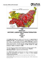
natura 2000 standard data form - Suffolk Coastal District Council
natura 2000 standard data form - Suffolk Coastal District Council
natura 2000 standard data form - Suffolk Coastal District Council

You also want an ePaper? Increase the reach of your titles
YUMPU automatically turns print PDFs into web optimized ePapers that Google loves.
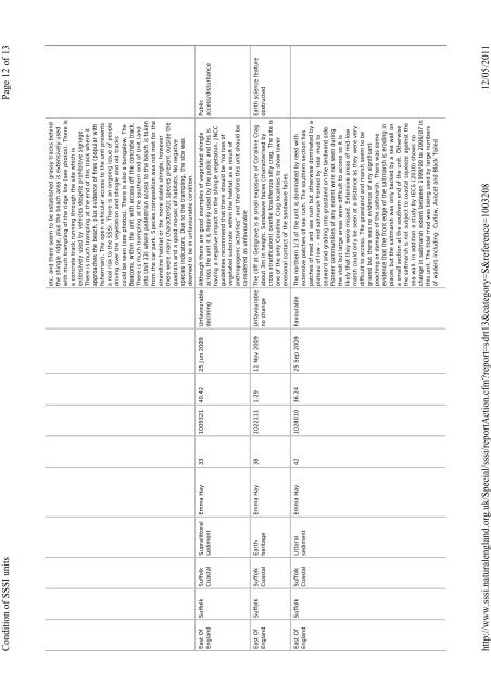
Page 12 of 13<br />
Condition of SSSI units<br />
etc, and there seem to be established grassy tracks behind<br />
the shingle ridge, plus the beach area is extensively used<br />
with much trampling of the ridge line (see photos). There is<br />
a concrete track running through the site which is<br />
extensively used by vehicles despite prohibitive signage.<br />
There is much trampling at the end of this track where it<br />
approaches the beach, plus evidence of fires (popular with<br />
fisherman). The open vehicular access to the unit presents<br />
a real risk to the SSSI. There is an ongoing issue of people<br />
driving over the vegetation and shingle and old tracks<br />
could be seen (see photos). There is also a bungalow, The<br />
Beacons, within the unit with access off the concrete track.<br />
There is much trampling at the southern end of Unit (and<br />
into Unit 33) where pedestrian access to the beach is taken<br />
from the car park. Species composition was not met for the<br />
strandline habitat or the more stable shingle, however<br />
there were many characteristic species present outside the<br />
quadrats and a good mosaic of habitats. No negative<br />
species indicators. Due to the trampling, the site was<br />
deemed to be in unfavourable condition.<br />
Public<br />
access/disturbance<br />
Although there are good examples of vegetated shingle<br />
across the unit it is heavily used by the public and this is<br />
having a negative impact on the shingle vegetation. JNCC<br />
guidelines recommend that there should be “no loss of<br />
vegetated substrate within the habitat as a result of<br />
anthropogenic activities” and therefore this unit should be<br />
considered as unfavourable<br />
Emma Hay 33 1009321 40.42 25 Jun 2009 Unfavourable<br />
declining<br />
Supralittoral<br />
sediment<br />
<strong>Suffolk</strong> <strong>Suffolk</strong><br />
<strong>Coastal</strong><br />
East Of<br />
England<br />
Earth science feature<br />
obstructed<br />
The cliff at Gedgrave is a small exposure of Coralline Crag<br />
about 3m in height. Sandwave facies (characterised by<br />
cross stratification) overlie fossilferous silty crag. The site is<br />
one of the only Coralline Crag localities to show lower<br />
erosional contact of the sandwave facies.<br />
Emma Hay 38 1022111 1.29 11 Nov 2009 Unfavourable<br />
no change<br />
Earth<br />
heritage<br />
<strong>Suffolk</strong> <strong>Suffolk</strong><br />
<strong>Coastal</strong><br />
East Of<br />
England<br />
Emma Hay 42 1028010 36.24 25 Sep 2009 Favourable The northern 1/3 of the unit is dominated by reed with<br />
extensive patches of sea rush. The southern section has<br />
patches of reed and sea rush but otherwise dominated by a<br />
plateau of low – mid saltmarsh fronted by tidal mud to<br />
seaward and grading into grassland on the landward side.<br />
Pioneer communities of any extent were not seen during<br />
the visit but large areas were difficult to access so it is<br />
likely that they were missed. Extensive areas of mid-low<br />
marsh could only be seen at a distance as they were very<br />
difficult to access. The grassland and marsh seem to be<br />
grazed but there was no evidence of any significant<br />
poaching or damage of the saltmarsh. There was some<br />
evidence that the front edge of the saltmarsh is eroding in<br />
places but the saltmarsh was only backed by a sea wall on<br />
a small section at the southern end of the unit. Otherwise<br />
the saltmarsh is not subject to coastal squeeze against the<br />
sea wall. In addition a study by IECS (2010) shows no<br />
change in saltmarsh extent between 1999/00 to 2006/07 in<br />
this unit. The tidal mud was being used by large numbers<br />
of waders including: Curlew, Avocet and Black Tailed<br />
Littoral<br />
sediment<br />
<strong>Suffolk</strong> <strong>Suffolk</strong><br />
<strong>Coastal</strong><br />
East Of<br />
England<br />
12/05/2011<br />
http://www.sssi.<strong>natura</strong>lengland.org.uk/Special/sssi/reportAction.cfm?report=sdrt13&category=S&reference=1003208