
Create successful ePaper yourself
Turn your PDF publications into a flip-book with our unique Google optimized e-Paper software.
61<br />
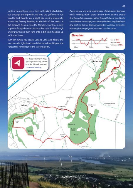
yards or so until you see a turn to the right which takes<br />
you through undergrowth and onto the golf course. You<br />
need to look hard to see a slight dip running diagonally<br />
across the fairway heading to the left of the masts in<br />
the distance. As you cross the fairways, you’ll see a very<br />
apparent footpath in the distance that runs firstly through<br />
undergrowth and then runs onto a dirt track heading up<br />
to Simons Lane.<br />
Turn left when you reach Simons Lane and follow Elevation the<br />
road round a right-hand bend that runs downhill past the<br />
Forest Hills hotel back to the starting point.<br />
Please ensure you wear appropriate clothing and footwear<br />
whilst walking. Whilst every care has been taken to ensure<br />
that the walk is accurate, neither the publisher or its editorial<br />
contributors can accept, and hereby disclaim, any liability to<br />
any party to loss or damage caused by errors or omissions<br />
resulting from negligence, accident or other cause.<br />
Elevation<br />
100m<br />
Lowest 23m<br />
Highest 141m<br />
50m<br />
Total ascent 425m<br />
0.0km 5.0km 10km<br />
For those with the OS Maps<br />
app on your desktop, mobile<br />
or tablet, this walk is named:<br />
JT-Frodsham-Helsby<br />
Hatley Lane<br />
Netherton<br />
M56<br />
A56<br />
B5393<br />
Sandstone Trail<br />
Beacon<br />
Hill<br />
A56<br />
The Coppice<br />
Helsby<br />
Bates Lane<br />
Hawthorn<br />
Farm<br />
Tarvin Road<br />
North Cheshire Way<br />
Woodhouse<br />
Hill<br />
Higher Mickledale<br />
Farm<br />
Helsby<br />
Hill<br />
Bates Lane<br />
Arboretum<br />
Manley Road<br />
Harmers<br />
Wood<br />
Foxhill<br />
Farm<br />
Foxhill<br />
Wood<br />
Tower<br />
Snidley<br />
Moor<br />
Burrows Lane<br />
Home Farm