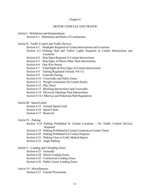
Chapter 6 MOTOR VEHICLES AND TRAFFIC ... - Town of Carrboro
Chapter 6 MOTOR VEHICLES AND TRAFFIC ... - Town of Carrboro
Chapter 6 MOTOR VEHICLES AND TRAFFIC ... - Town of Carrboro

You also want an ePaper? Increase the reach of your titles
YUMPU automatically turns print PDFs into web optimized ePapers that Google loves.
<strong>Chapter</strong> 6<br />
<strong>MOTOR</strong> <strong>VEHICLES</strong> <strong>AND</strong> <strong>TRAFFIC</strong><br />
Article I - Definitions and Interpretations<br />
Section 6-1 Definitions and Rules <strong>of</strong> Construction<br />
Article II - Traffic Control and Traffic Devices<br />
Section 6-2 Stoplights Required at Certain Intersections and Locations<br />
Section 6-3 Flashing Red and Yellow Lights Required at Certain Intersections and<br />
Locations<br />
Section 6-4 Stop Signs Required At Certain Intersections<br />
Section 6-5 Stop Signs At Places Other Than Intersections<br />
Section 6-6 One-Way Streets<br />
Section 6-7 Yield Right-<strong>of</strong>-Way Signs At Certain Intersections<br />
Section 6-8 Turning Regulated (Amend. 9/6/11)<br />
Section 6-9 Unlawful Passing<br />
Section 6-10 Crosswalks and Safety Zones<br />
Section 6-11 Weight Limitations On Certain Streets<br />
Section 6-12 Play Street<br />
Section 6-13 Blocking Intersections and Crosswalks<br />
Section 6-14 Driveway Openings Near Intersections<br />
Section 6-14.1 Bikeway and Pedestrian Path Regulations<br />
Article III - Speed Limits<br />
Section 6-15 General Speed Limit<br />
Section 6-16 Speed Limits<br />
Section 6-17 Reserved<br />
Article IV - Parking<br />
Section 6-18 Parking Prohibited In Certain Locations - No Traffic Control Devices<br />
Required<br />
Section 6-19 Parking Prohibited In Certain Locations at Certain Times<br />
Section 6-20 Parking Prohibited For Certain Purposes<br />
Section 6-21 Parking Close to Curb; Marked Spaces<br />
Section 6-22 Angle Parking<br />
Article V - Loading and Unloading Zones<br />
Section 6-23 Generally<br />
Section 6-24 School Loading Zones<br />
Section 6-25 Commercial Loading Zones<br />
Section 6-26 Public Carrier Loading Zones<br />
Article VI - Miscellaneous<br />
Section 6-27 Funeral Processions<br />
6-1
Section 6-28 Special Provisions for Bicycles, Toy Vehicles, Etc.<br />
Section 6-28.1 Jogging at Night Without Reflective Clothing Prohibited<br />
Section 6-28.2 Solicitation <strong>of</strong> Business from Motor Vehicles<br />
Section 6-28.3 House Moving (Amend. 1/10/89)<br />
Article VII - Registration and License Tax<br />
Section 6-29 Payment <strong>of</strong> Motor Vehicle License Tax<br />
Sections 6-30 through 6-33 Reserved<br />
Article VIII - Bicycles<br />
Section 6-34 Establishment <strong>of</strong> Bikeways (Amend. 9/6/11)<br />
Section 6-35 Direction <strong>of</strong> Travel<br />
Section 6-36 Restrictions Upon Use <strong>of</strong> Bikeways by Motor Vehicles<br />
Section 6-37 Shared Usage by Bicyclists and Pedestrians<br />
Section 6-38 Bicycles and Motor Vehicles Prohibited on Certain Sidewalks<br />
Section 6-39 Bicycles Subject to General Statutes<br />
Section 6-40 Voluntary Registration <strong>of</strong> Bicycles<br />
Section 6-40.1 Helmets Required for Bicycles<br />
Article IX - Penalties and Remedies<br />
Section 6-41 Penalties and Remedies<br />
6-2
Article I<br />
DEFINITIONS <strong>AND</strong> INTERPRETATIONS<br />
Section 6-1. Definitions and Rules <strong>of</strong> Construction<br />
Unless otherwise specifically provided, or unless otherwise clearly required by the context, the<br />
words and phrases defined in this section shall have the meaning indicated when used in this<br />
chapter.<br />
(1) Administrator: The public works director or any other person designated by the<br />
Manager to perform the functions assigned by this chapter to the administrator<br />
whenever this ordinance authorizes or requires the administrator to install traffic<br />
control devices controlling parking or regulating the amount <strong>of</strong> movement <strong>of</strong> traffic<br />
on, to, or from a state highway system street and the installation <strong>of</strong> such a device is<br />
in practice a function <strong>of</strong> the State Department <strong>of</strong> Transportation, the administrator<br />
may discharge his responsibility by requesting the State Department <strong>of</strong><br />
Transportation to install such device.<br />
(2) Bicycle: A non-motorized human powered passenger vehicle with two or three<br />
wheels with rubber tires, a frame, handle bars and one or two saddle seats. (Amend.<br />
3/10/92)<br />
(3) Bike Lane: That portion <strong>of</strong> the roadway set aside for the use <strong>of</strong> bicycles. (Amend.<br />
3/10/92)<br />
(4) Bike Path: A pathway primarily designed for bicycles (pedestrian traffic may also<br />
be permitted) located either within that portion <strong>of</strong> a street right-<strong>of</strong>-way that is<br />
separate from the roadway or within a public easement other than a street right-<strong>of</strong>way.<br />
(Amend. 3/10/92)<br />
(5) Bikeway: A thoroughfare suitable for bicycles (and pedestrians), including bike<br />
lanes and bike paths. (Amend. 3/10/92)<br />
(6) Driver: The operator <strong>of</strong> a vehicle.<br />
(7) Highway or Street: The entire width between property or right-<strong>of</strong>-way lines <strong>of</strong> every<br />
way or place <strong>of</strong> whatever nature, when any part there<strong>of</strong> is open to the use <strong>of</strong> the<br />
public as a matter <strong>of</strong> right for the purposes <strong>of</strong> vehicular traffic. The terms<br />
"highway" or "street" or a combination <strong>of</strong> the two terms shall be used synonymous.<br />
(8) Intersection: The area embraced within the prolongation <strong>of</strong> the lateral curblines or,<br />
if none, then the lateral edge <strong>of</strong> roadway lines <strong>of</strong> two or more highways which join<br />
one another at any angle whether or not one such highway crosses the other.<br />
Where a highway includes two roadways 30 feet or more apart, then every crossing<br />
<strong>of</strong> each roadway <strong>of</strong> such divided highway by a intersecting highway shall be<br />
regarded as a separate intersection. In the event that such intersecting highway also<br />
6-3
includes two roadways 30 feet or more apart, then every crossing <strong>of</strong> two roadways<br />
<strong>of</strong> such highways shall be regarded as a separate intersection.<br />
(9) Local Street: A street within the town that is not part <strong>of</strong> the State Highway System.<br />
(10) Mo-ped: A vehicle having two or three wheels and operable pedals and equipped<br />
with an internal combustin motor that does not exceed 50 cubic centimeters piston<br />
displacement or an electric motor which cannot propel the vehicle at a speed greater<br />
than 20 m.p.h. on a level surface. (Amend. 3/10/92)<br />
(11) Motor Vehicle: Every vehicle which is self-propelled and every vehicle designed to<br />
run upon the highways which is pulled by a self-propelled vehicle. However, this<br />
definition shall not include mo-peds as defined in subdivision (10) above. (Amend.<br />
3/10/92)<br />
(12) Operator: A person in actual physical control <strong>of</strong> a vehicle which is in motion or<br />
which has the engine running.<br />
(13) Parking or Standing: A vehicle is parked or is permitted to stand when it is stopped<br />
and allowed to remain in a fixed location for any duration <strong>of</strong> time, whether attended<br />
or unattended. Except where the context clearly indicates otherwise, the limitations<br />
on parking and standing in this chapter apply only to locations within a street<br />
right-<strong>of</strong>-way. In no case do these limitations apply when a vehicle is stopped to<br />
avoid conflict with other traffic or in compliance with law or the directions <strong>of</strong> a<br />
police <strong>of</strong>ficer or traffic control device or as the result <strong>of</strong> an emergency or because<br />
the vehicle is disabled.<br />
(14) Roadway: That portion <strong>of</strong> a highway improved, designed, or ordinarily used for<br />
vehicular traffic, exclusive <strong>of</strong> the shoulder. In the event a highway includes two or<br />
more separate roadways the term "roadway" as used herein shall refer to any such<br />
roadway separately but not to all such roadways collectively.<br />
(15) Safety Zone: Traffic island or other space <strong>of</strong>ficially set aside within a highway for<br />
the exclusive use <strong>of</strong> pedestrians and which is so plainly marked or indicated by<br />
proper signs as to be plainly visible at all times while set apart as a safety zone.<br />
(16) Shared Lane Marking: A pavement marking, as described in Section 9C.07 <strong>of</strong> the<br />
Manual on Uniform Traffic Control Devices, 2009 Edition, designed to assist<br />
persons riding bicycles with lateral positioning in narrow travel lanes, alert road<br />
users <strong>of</strong> the lateral location bicyclists are likely to occupy within the traveled way,<br />
encourage safe passing <strong>of</strong> bicyclists by motorists, and reduce the incidence <strong>of</strong><br />
wrong-way bicycling. (Amend. 9/21/2010)<br />
(17) State Highway System Street: A street within the town that is part <strong>of</strong> the State<br />
Highway System Streets. Whenever this chapter regulates parking or the movement<br />
<strong>of</strong> traffic on, to, or from a State Highway System Street, then to the extent that<br />
concurrence by the State Department <strong>of</strong> Transportation is necessary (by passage <strong>of</strong><br />
6-4
a concurring ordinance or otherwise) such regulation shall not become effective<br />
until such concurrence is obtained. Streets listed in this chapter that are part <strong>of</strong> the<br />
State Highway System are designated by an asterisk(*).<br />
(18) Street: The entire width between property or right-<strong>of</strong>-way lines <strong>of</strong> every way or<br />
place <strong>of</strong> whatever nature, when any part there<strong>of</strong> is open to the use <strong>of</strong> the public as a<br />
matter <strong>of</strong> right for the purpose <strong>of</strong> vehicular traffic. The terms "highway" or "street"<br />
shall be used synonymously.<br />
(19) Traffic Control Device: Any sign, signal, marking or other device placed or erected<br />
pursuant to a lawfully adopted ordinance, designed to regulate, warn, guide, or<br />
control traffic.<br />
(20) Traffic Control Signal: Any device designed to regulate, guide, or control traffic<br />
through the use <strong>of</strong> alternating or flashing lights or by some other mechanical means.<br />
(21) Vehicle: Every device in, upon, or by which any person or property is or may be<br />
transported or drawn upon a highway, excepting devices moved by human power or<br />
used exclusively upon fixed rails or tracks, provided, that for the purposes <strong>of</strong> this<br />
chapter, bicycles shall be deemed vehicles and every rider <strong>of</strong> a bicycle upon a<br />
highway shall be subject to the provisions <strong>of</strong> this chapter applicable to the driver <strong>of</strong><br />
a vehicle except those which by their nature can have no application.<br />
6-5
Article II<br />
<strong>TRAFFIC</strong> CONTROL <strong>AND</strong> <strong>TRAFFIC</strong> CONTROL DEVICES<br />
Section 6-2. Stoplights Required at Certain Intersections and Locations<br />
The administrator shall erect or install mechanical stoplights to regulate vehicular and<br />
pedestrian traffic at the following intersections and locations. The effect <strong>of</strong> such stoplights on<br />
vehicles and pedestrians shall be as provided in G.S. 20-158 and 20-172.<br />
Merritt Mill Road* at Main Street* (East)<br />
East Main Street* at Rosemary Street<br />
East Main Street* at Weaver Street*<br />
East Main Street* at Greensboro Street*<br />
Weaver Street* at North Greensboro Street*<br />
West Main Street* at Weaver Street*<br />
East Main Street* at Lloyd Street (Amend. 3/2/04)<br />
Merritt Mill Road* at Cameron Avenue (Amend. 3/2/04)<br />
Merritt Mill Road* at South Greensboro Street* (Amend. 3/2/04)<br />
Smith Level Road* at 54 Bypass* entrance and exit ramps<br />
Smith Level Road* at Public Works Drive / Frank Porter Graham Elementary Entrance<br />
(Amend. 3/2/04)<br />
Smith Level Road* at BPW Club Road (Amend. 3/2/04)<br />
Smith Level Road* at Culbreth Road* (Amend. 3/2/04)<br />
Jones Ferry Road* at 54 Bypass* entrance and exit ramps (Amend. 3/2/04)<br />
Jones Ferry Road* at Willow Creek Shopping Center entrance (Amend. 3/2/04)<br />
Jones Ferry Road* at Old Fayetteville Road* (Amend. 3/2/04)<br />
West Main Street* at Jones Ferry Road* (Amend. 3/2/04)<br />
West Main Street* at 54 Bypass* (Amend. 3/2/04)<br />
Hwy 54* at Old Fayetteville Road* (Amend. 3/2/04)<br />
Estes Drive* at North Greensboro Street* (Amend. 3/2/04)<br />
Hillsborough Road* at Old Fayetteville Road* / Old 86* (Amend. 3/2/04)<br />
West Poplar Avenue at 54 Bypass* (Amend. 2/14/06)<br />
Section 6-3. Flashing Red or Yellow Lights Required at Certain Intersections and Locations<br />
The administrator shall erect or install mechanical red or yellow blinking or flashing lights<br />
as provided below at the indicated intersections and other locations. The effect <strong>of</strong> such blinking or<br />
flashing red or yellow lights on vehicles shall be as provided in G.S. 20-158 and 20-172.<br />
Intersections: None<br />
Other Locations: West Main Street* near Fidelity Street<br />
West Main Street* near Blackwood Drive<br />
Hillsborough Road* southwest <strong>of</strong> Pine Street<br />
Hillsborough Road* west <strong>of</strong> Cates Farm Road (Amend. 3/2/04)<br />
Hillsborough Road* east <strong>of</strong> Barington Hills Road (Amend. 3/2/04)<br />
East Main Street* at railroad crossing (Amend. 3/2/04)<br />
Merritt Mill Road* at railroad crossing (Amend. 3/2/04)<br />
6-6
Estes Drive* at railroad crossing (Amend. 3/2/04)<br />
Seawell School Road* at railroad crossing (Amend. 3/2/04)<br />
Jones Ferry Road* east <strong>of</strong> Davie Road (Amend. 2/14/06)<br />
Jones Ferry Road* west <strong>of</strong> Davie Road (Amend. 2/14/06)<br />
Section 6-4. Stop Signs Required at Certain Intersections<br />
(a) The second named street in the following list <strong>of</strong> intersections is hereby designated as a<br />
main traveled or through street, and the administrator shall erect stop signs on the first named street<br />
at the entrance to the main traveled or through street. The effect <strong>of</strong> such stop signs on vehicles and<br />
pedestrians shall be as provided in G.S. 20-158 and 20-172. (Amend. 1/7/92, 9/26/2000,<br />
5/20/03,11/01/11)<br />
Stop Street Through Street<br />
Abbey Ln Hwy 54<br />
Aberdeen Court Blueridge Road<br />
Alabama Avenue Jones Ferry Road*<br />
Amber Ct Bolin Creek Dr<br />
Anderson Park Rd Hwy 54<br />
Arbor Creek Court<br />
Hogan Woods Circle (Amend. 3/2/04)<br />
Ashe Street<br />
Shelton Street<br />
Ashe Street W. Main Street*<br />
Autumn Drive (Amend. 2/12/80) Barington Hills Road<br />
Barington Hills Drive (Amend. 2/12/80) Old 86* (Deleted 3/2/04)<br />
Balmoral Place<br />
Skye Drive (Amend. 2/14/06)<br />
Barington Hills Road<br />
Hillsborough Rd.* (Amend. 3/2/04)<br />
Barnes Street<br />
Jones Ferry Road*<br />
Bay View Drive Long Meadows Road<br />
Bel Arbor Ln Hillsborough Rd<br />
Bert Street Davie Road<br />
Bim St Fidelity St<br />
Bim Street Jones Ferry Road*<br />
Blackwood Drive W. Main Street*<br />
Blackwood Drive W. Poplar Avenue<br />
Blocker Road<br />
Shadow Ridge Place (Amend. 3/2/04)<br />
Blueridge Rd<br />
Spring Valley Rd<br />
Blueridge Road Hillsborough Road*<br />
Bolin Creek Dr Wild Oak Ln<br />
Bolin Forest Dr Bolin Creek Dr<br />
Bolin Forest Dr.<br />
N. Greensboro St.* (Amend. 3/2/04)<br />
Boyd St<br />
E Main St<br />
BPW Club Rd.<br />
Tar Hill Drive (Amend. 3/2/04)<br />
Brace Lane<br />
Reynard Road (Amend. 2/14/06)<br />
Brendan Court<br />
Staffield Lane (Amend. 2/14/06)<br />
Bruton Dr<br />
Hillsborough Rd<br />
Buck Taylor Trl Pathway Dr<br />
Buckeye Ln Farm House Dr<br />
Bugle Court Tallyho Trail (Amend. 2/14/06)<br />
6-7
Burns Place<br />
Claymore Road (Amend. 2/14/06)<br />
Calumet Court<br />
Morningside Drive<br />
Camden Lane<br />
Homestead Road * Amend.2/14/06)<br />
Canton Court (Amend. 2/12/80)<br />
Barington Hills Road<br />
Carol Street Lorraine Street<br />
Carol Street Old Fayetteville Road*<br />
Cates Farm Rd Hillsborough Rd<br />
Cathy Road Gary Road<br />
Cathy Road Lynn Drive<br />
Center Street Weaver Street<br />
Cheek Street N. Greensboro Street*<br />
Cheek Street Hillsborough Road*<br />
Cheswick Ct High St<br />
Claymore Road<br />
Rogers Road* (Amend. 2/14/06)<br />
Coaston Avenue<br />
Davie Road (Amend. 6/22/2004)<br />
Cobb Street Lloyd Street<br />
Cobb Street Broad Street<br />
Colson Avenue<br />
Davie Road (Amend. 6/22/2004)<br />
Creek View Circle (Amend. 2/22/94) Waterside Drive<br />
Creekview Cir Waterside Dr<br />
Crest Street Pleasant Drive<br />
Daffodil Ln Old Pittsboro Rd<br />
Dairy Court Long Meadows Road (Amend. 3/2/04)<br />
Dairy Glen Rd.<br />
Hogan Hills Rd. (Amend. 3/2/04)<br />
Davie Rd (from the North)<br />
W Poplar Ave<br />
Davie Rd (from the South) W Poplar Ave<br />
Davie Road Jones Ferry Road*<br />
Davie Road W. Main Street*<br />
Deer St Quail Roost Dr<br />
Deer St Lisa Dr<br />
Dillard St Hillsborough Rd<br />
Dove St Hillsborough Rd<br />
Dove St Rainbow Dr<br />
Downing Court (Amend. 2/12/80 Autumn Drive<br />
Drayton Ct Pathway Dr<br />
East Carr Street S. Greensboro Street*<br />
Ellsworth Pl Tramore Dr<br />
Elm Street Weaver Street<br />
Elm Street Shelton Street<br />
Eugene St Hargraves St<br />
Fairfield Ct Hanford Rd<br />
Farm House Dr Old NC 86<br />
Fidelity Street W. Main Street*<br />
Fidelity Street Davie Road<br />
Fowler Street Broad Street<br />
Fowler Street Lloyd Street<br />
Fowler Street Starlite Drive (Amend. 3/2/04)<br />
6-8
Frances Shetley Bikeway N Greensboro St<br />
Frances Shetley Bikeway Shelton St<br />
Gary Road Poplar Avenue<br />
Gateridge Pl Manor Ridge Rd<br />
Glenview Pl Waverly Forest Ln<br />
Glosson Circle Davie Road<br />
Gloucester Court<br />
Camden Lane (Amend. 2/14/06)<br />
Goldston Avenue<br />
High Street<br />
Gracewood Pl Pathway Dr<br />
Hanford Rd Pathway Dr<br />
Hanna Street N. Greensboro Street<br />
High St W Main St<br />
High Street Hillsborough Road*<br />
Highway 54 Jones Ferry Road*<br />
Hill St Lloyd St<br />
Hill Street Broad Street<br />
Hillcrest Avenue Estes Drive<br />
Hillsborough Roard*<br />
N. Greensboro St*<br />
Hillsborough Road<br />
W. Main Street*<br />
Hillview Drive Pleasant Drive<br />
Hogan Glen Court Long Meadows Road (Amend. 3/2/04)<br />
Hogan Hills Road<br />
Old 86*<br />
Hogan Ridge Court<br />
Long Meadows Road (Amend. 3/2/04)<br />
Hogan Woods Circle<br />
Commons Way Drive<br />
Hosiery St Lloyd St<br />
Hunter Place N. Greensboro Street*<br />
Huntsman Court<br />
Tallyho Trail (Amend. 2/14/06)<br />
Inverness Way<br />
Claymore Road (Amend. 2/14/06)<br />
James Street<br />
Hillsborough Road*<br />
James Street W. Main Street*<br />
Juniper Court Manor Ridge (Amend. 12/8/92)<br />
Kay Street Davie Road<br />
Keith Road Gary Road<br />
Keith Road Lynn Drive<br />
King Street Barnes Street<br />
Kit Lane<br />
Tallyho Trail (Amend. 2/14/06)<br />
Laurel Ave<br />
Weaver St<br />
Lair Court<br />
Tallyho Trail (Amend. 2/14/06)<br />
Lake Hogan Farm Road<br />
Homestead Road*<br />
Lake Manor Road<br />
Lake Hogan Farm Rd (Amend. 3/2/04)<br />
Lake Ridge Place<br />
Lake Manor Road (Amend. 3/2/04)<br />
Laurel Ave (from the South)<br />
Jones Ferry Rd<br />
Laurel Avenue W Main Street*<br />
Laurel Avenue (from the North) Jones Ferry Road*<br />
Libba Cotton Bikeway Brewer Ln<br />
Libba Cotton Bikeway Brewer Ln<br />
Libba Cotton Bikeway Roberson St<br />
Lilac Drive Oleander Road<br />
6-9
Lilac Drive W Poplar Avenue<br />
Lindsay Street Weaver Street<br />
Lisa Dr Quail Roost Dr<br />
Lloyd St Hill St<br />
Lloyd Street E. Main Street* (Deleted 3/2/04)<br />
Lock Laven Lane<br />
Long Meadows Road<br />
Lorraine Street<br />
Lynn Drive<br />
Manor Ridge Drive<br />
Claymore Road (Amend. 2/14/06)<br />
Hogan Hills Road (Amend. 3/2/04)<br />
Hillsborough Road*<br />
Maple Ave E Carr St<br />
Maple Ave Ext Roberson St<br />
Maple Ave Ext E Carr St<br />
Mary Street Simpson Street<br />
Mary Street Lorraine Street<br />
Melba Circle<br />
Meadow Run Court<br />
Melba Circle<br />
Oleander Road (Amend. 3/2/04)<br />
Willow Oak Lane (Amend.<br />
12/8/92)<br />
Lindsay Street (Deleted 3/2/04)<br />
Rogers Road* (Amend. 2/14/06)<br />
Lorraine Street (Amend. 3/2/04)<br />
Merritt St Lindsay St<br />
Michael's Way Sunset Creek Cir<br />
Millrock Ct Bolin Creek Dr<br />
Milton Dr Cheek St<br />
Milton Drive N. Greensboro Street*<br />
Misty Pines Pl Manor Ridge Rd<br />
Morgan Hill Court<br />
Manor Ridge Road (Amend. 3/2/04)<br />
Morningside Drive<br />
N. Greensboro Street*<br />
Morningside Drive Blueridge Road<br />
Neville Street Davie Road<br />
Neville Street Alabama Avenue<br />
North Fields Circle Long Meadows Road (Amend.<br />
2/14/06)<br />
North Fields Circle Long Meadows Road (Amend.<br />
2/14/06)<br />
N. Hawick Court<br />
Claymore Road (Amend. 2/14/06)<br />
N. Hound Court<br />
Reynard Road (Amend. 2/14/06)<br />
Oak Avenue<br />
N Greensboro St<br />
Oak Avenue Weaver Street<br />
Oak Avenue Ext N Greensboro St<br />
Oak Glen Place<br />
Waverly Forest Lane (Amend. 3/2/04)<br />
Oak Spring Court<br />
Orchard Lane (Amend. 12/8/92)<br />
Oak St Greensboro St<br />
Oak St Hillsborough Road*<br />
Old Fayetteville Road (from University<br />
Lake)<br />
Old Fayetteville Rd<br />
Old Fayetteville Road* (Amend. 2/12/80) Old 86* (Deleted 3/2/04)<br />
Old Pittsboro Road S. Greensboro Street*<br />
Old Pittsboro Road S. Greensboro Street*<br />
6-10
Oleander Rd Lynn Dr (Deleted 3/2/04)<br />
Oleander Rd Hwy 54<br />
Oleander Road Gary Road<br />
Orchard Lane BPW Club Road (Amend. 12/8/92)<br />
Painted Turtle Lane<br />
Turtleback Crossing Dr. (Amend.<br />
3/2/04)<br />
Palomar Point Rossburn Way (Deleted 11/1/11)<br />
Parker Street N. Greensboro Street<br />
Parkview Ave Pathway Dr<br />
Parkview Ave Hillsborough Rd<br />
Pine Hill Dr W Main St<br />
Pine Street N. Greensboro Street*<br />
Pine Street Hillsborough Road*<br />
Pleasant Drive N. Greensboro Street*<br />
Poplar Avenue W. Main Street*<br />
Poplar Avenue N. Greensboro Street*<br />
Poplar Avenue (Amend. 2/12/80) Old Fayetteville Road<br />
Prince Street King Street*<br />
PTA Bikeway<br />
PTA Bikeway<br />
Quail Roost Road<br />
W. Carr Street (Amend. 3/2/04)<br />
Main Street (Amend. 3/2/04)<br />
James Street<br />
Queen Street Prince Street<br />
Queen Street Barnes Street<br />
Rainbow Drive Hillsborough Road*<br />
Rand Road S. Greensboro Street*<br />
Randolph Court<br />
Hogan Woods Circle (Amend. 3/2/04)<br />
Raven Ln<br />
W Poplar Ave<br />
Red Sunset Pl Purple Leaf Pl<br />
Redfoot Run Road<br />
Hogan Woods Circle (Amend. 3/2/04)<br />
Renee Lynn Court<br />
Rock Haven Road (Amend. 3/2/04)<br />
Reynard Road<br />
Tallyho Trail (Amend. 2/14/06)<br />
Richard Dixon Ct<br />
Robert Hunt Dr<br />
Richland Ct Pathway Dr<br />
River Creek Pl Morgan Hill Ct<br />
Roberson Street S. Greensboro Street*<br />
Robert Hunt Dr Greensboro St<br />
Roberts Street Merritt Mill Road*<br />
Rock Haven Rd Smith Level Rd<br />
Rock Spring Court Spring Valley Rd<br />
Rockgarden Rd Cobblestone Dr<br />
Rockgarden Rd Cobblestone Dr<br />
Rocky Point Bel Arbor Ln<br />
Rossburn Way Culbreth Rd<br />
Shadow Ridge Place<br />
Long Meadows Road (Amend. 3/2/04)<br />
Shelton Street<br />
Shelton Street at <strong>Carrboro</strong><br />
Elementary<br />
Shelton Street Hillsborough Road*<br />
Shelton Street N Greensboro Street*<br />
6-11
Short Street N. Greensboro Street*<br />
Short Street Center Avenue<br />
Simpson Street W. Main Street*<br />
Simpson Street Hillsborough Road<br />
Skye Drive<br />
South Fields Circle<br />
Sterling Bridge Road (Amend.<br />
2/14/06)<br />
Long Meadows Road<br />
South Fields Circle Long Meadows Road<br />
S. Hawick Court<br />
S. Hound Court<br />
Spring Valley Road<br />
Claymore Road (Amend. 2/14/06)<br />
Reynard Road (Amend. 2/14/06)<br />
Morningside Drive<br />
Stable Rd Bolin Forest Dr<br />
Staffield Lane<br />
Tallyho Trail (Amend. 2/14/06)<br />
Starlite Dr<br />
Starlite Dr<br />
Starlite Dr Sunset Dr<br />
Starlite Dr Broad St<br />
Sterling Bridge Road<br />
Claymore Road (Amend. 2/14/06)<br />
Sterling Bridge Road<br />
Homestead Road*(Amend. 2/14/06)<br />
Stratford Dr<br />
Autumn Dr (Amend. 1/11/05)<br />
Stratford Dr Homestead Rd<br />
Strowd Ln Old Fayetteville Rd<br />
Sudbury Ln Pathway Dr<br />
Sue Ann Court N. Greensboro Street*<br />
Suffolk Pl Tramore Dr<br />
Sunset Creek Cir Farm House Dr<br />
Sunset Creek Cir Farm House Dr<br />
Sunset Drive E. Rosemary Street<br />
Sunset Ridge Ln Sunset Creek Cir<br />
Sweetbay Pl Roberson St<br />
Tallyho Trail<br />
Rogers Road* (Amend. 2/14/06)<br />
Tanglewood Lane (Amend. 3/11/86) Westbrook Drive<br />
Todd Street N. Greensboro Street<br />
<strong>Town</strong> Hall Parking Bim St<br />
<strong>Town</strong> <strong>of</strong> <strong>Carrboro</strong> Parking Laurel Ave<br />
<strong>Town</strong> <strong>of</strong> <strong>Carrboro</strong> Parking <strong>Town</strong> <strong>of</strong> <strong>Carrboro</strong> Parking<br />
<strong>Town</strong> <strong>of</strong> <strong>Carrboro</strong> Parking Bim St<br />
<strong>Town</strong>e Ridge Lane<br />
Lake Hogan Farms Rd (Amend.<br />
3/2/04)<br />
Tramore Drive<br />
Colfax Drive (Amend. 3/2/04)<br />
Turtleback Crossing Dr.<br />
Lake Hogan Frm Rd. (Amend. 3/2/04)<br />
W Poplar Ave Ext<br />
W Poplar Ave<br />
W Poplar Avenue W. Main Street*<br />
W Poplar Avenue (from the East) (Amend.<br />
2/12/80) (Deleted 2/14/06)<br />
Highway 54 Bypass*<br />
W Poplar Avenue (from the West) Highway 54 Bypass<br />
(Amend. 2/12/80) (Deleted 2/14/06)<br />
Wannamaker Pl Sweetbay Pl<br />
Waterside Drive (Amend. 2/22/94) Spring Valley Dr<br />
6-12
Watters Road (Amend. 2/2/93) N. Greensboro Street*<br />
Waverly Forest Ln Hanford Rd<br />
Weathervane Drive<br />
N. Greensboro St. (Amend. 3/2/04)<br />
Weathervane Drive<br />
Stable Road (Amend. 3/2/04)<br />
Weaver St<br />
Laurel Ave<br />
Webb Court Blueridge Road<br />
West Carr Street S. Greensboro Street*<br />
Wesley Street<br />
Hargraves Street (Amend. 3/2/04)<br />
Westbrook Dr<br />
Hwy 54<br />
Westview Drive W. Main Street*<br />
Westview Drive W. Main Street*<br />
Whitmore Circle<br />
Staffield Lane (Amend. 2/14/06)<br />
Wild Oak Ln<br />
Pathway Dr<br />
Williams St At Wilson Park<br />
Williams Street N. Greensboro Street*<br />
Willow Oak Lane Smith Level Road* (Amend.<br />
Winsome Ln<br />
12/8/92)<br />
Old Fayetteville Rd<br />
Woods Walk Ct Bel Arbor Ln<br />
Wrenn Pl Pathway Dr<br />
Wyndham Dr Rockgarden Rd<br />
Wyndham Dr (from N) Tramore Dr (Deleted 3/2/04)<br />
Wyndham Dr (from S) Tramore Dr (Deleted 3/2/04)<br />
Yeargen Pl Tripp Farm Rd<br />
(b) The intersection <strong>of</strong> the following streets are declared to be 4-way intersections, and the<br />
administrator shall erect stop signs on each street at the entrance to the intersection. The effect <strong>of</strong><br />
such stop sign on vehicles and pedestrians shall be as provided in G.S. 20-158 and 20-172.<br />
(Amend. 7/2/80, 9/26/2000, 11/01/11)<br />
Shelton Street Oak Avenue<br />
Spring Valley Drive (Amend.2/22/94) Pathway Drive<br />
Westbrook Drive Berryhill Drive (Amend. 5/26/87)<br />
Autumn Drive Cates Farm Road<br />
Beechwood Drive Westbrook Drive<br />
Carol Street James Street<br />
Cates Farm Road RockGarden Drive<br />
James Street Lorraine Street<br />
James Street Rainbow Drive<br />
Orchard Lane Manor Ridge Drive<br />
Pathway Drive Cates Farm Road<br />
Pathway Drive Cobblestone Drive<br />
Pathway Drive Spring Valley Drive<br />
Pathway Drive Tripp Farm Road<br />
Pathway Drive Robert Hunt Drive<br />
Poplar Avenue Ashe Street<br />
6-13
Poplar Avenue Elm Street<br />
Poplar Avenue Lindsay Street<br />
Poplar Avenue Oak Avenue<br />
Shelton Street Lindsay Street<br />
Stratford Drive Tramore Drive<br />
Tramore Drive Wyndham Drive (Amend. 6/4/2002)<br />
William White Court and Robert Cook Court Robert Hunt Drive<br />
Phipps Street Simpson Street<br />
(c) The intersections <strong>of</strong> the following streets are declared to be 3-way intersections, and<br />
the administrator shall erect stops signs on each street at the entrance to the intersection. The effect<br />
<strong>of</strong> such stop signs on vehicles and pedestrians shall be as provided in G.S. 20-158 and 20-172.<br />
(Amend. 1/7/92, 5/20/03, 11/01/11)<br />
Wyndham Dr Autumn Dr<br />
Cates Farm Road Garden Gate Road<br />
Commons Way Drive Lake Hogan Farm Road<br />
Creekview Circle (southern intersection) Waterside Drive (Amend. 11/21/06)<br />
Creekview Circle (northern intersection) Waterside Drive (Amend. 11/21/06)<br />
Hogan Woods Circle Lake Hogan Farm Road<br />
Jasmine Court Robert Hunt Drive<br />
John Martin Court Robert Hunt Drive<br />
Lake Manor Road Lake Hogan Farm Road<br />
Lisa Drive Rainbow Drive<br />
Lisa Drive Carol Street<br />
Long Meadows Road Lake Hogan Farm Road (Amend. 5/20/03)<br />
Morningside Drive<br />
Spring Valley Road (Amend. 6/6/06)<br />
Oak Avenue<br />
Merritt Street<br />
Phipps Street Lorraine Street<br />
Pleasant Drive Mulberry Street<br />
Rossburn Way Palomar Point (Amend. 11/01/11)<br />
Stratford Drive Autumn Drive (Amend. 1/11/05)<br />
(d) The administrator shall erect stop signs at the locations indicated below. The effect <strong>of</strong> such<br />
stop signs on vehicles and pedestrians shall be as provided in G.S. 20-158 and 20-172. (Amend.<br />
7/14/81, 1/7/92)<br />
Stop Street Approach From Intersecting Street<br />
Autumn Drive (Amend. 2/13/96) East Stratford Drive<br />
Barington Hills Drive South Bruton Drive<br />
Bruton Drive East and West Barington Hills Drive<br />
Section 6-5. Stop Signs at Places Other Than Intersections<br />
The Board finds that a particular hazard exists at the locations enumerated below, and the<br />
administrator is hereby directed to erect a stop sign at the locations indicated. The effect <strong>of</strong> such a<br />
stop sign on vehicles and pedestrians shall be as provided in G.S. 20-158 and 20-172.<br />
6-14
All stop signs located in the city limits <strong>of</strong> <strong>Carrboro</strong> are located at intersections.<br />
Section 6-6. One-Way Streets<br />
(a) Whenever a street is designated a one-way street and traffic control devices are installed<br />
in accordance with subsection (b) <strong>of</strong> this section, no person may drive any vehicle on such street<br />
except in the direction indicated by the traffic control devices. (Note: G.S. 20-165.1 makes it<br />
unlawful to drive contrary to a sign erected by the State Department <strong>of</strong> Transportation).<br />
(b) The following streets are hereby designated one-way streets as indicated below, and the<br />
administrator shall install appropriate traffic control devices at every intersection clearly indicating<br />
the direction <strong>of</strong> lawful traffic movement.<br />
(1) Shelton Street is one-way north and west from its intersection with Ashe Street<br />
to its intersection with Hillsborough Road.<br />
(2) Poplar Avenue from West Main Street to Greensboro Street one-way in a west<br />
to east direction. (Amend. 7/22/80, but effective upon completion <strong>of</strong> the North<br />
Greensboro Street Project and remain in effect for a period <strong>of</strong> six months<br />
thereafter.)<br />
Section 6-7. Yield Right-<strong>of</strong>-Way Signs at Certain Intersections<br />
The second named street in the following list <strong>of</strong> intersections is hereby designated as a main<br />
traveled or through street, and the administrator shall erect yield right-<strong>of</strong>-way signs on the first<br />
named street at the entrance to the main traveled or through street. The effect <strong>of</strong> such yield signs on<br />
vehicles and pedestrians shall be as provided in G.S. 20-148 and 20-172.<br />
Yield Street Through Street<br />
Entrance ramps to 54 Bypass east 54 Bypass*<br />
and west from Smith Level and<br />
Jones Ferry Roads<br />
Section 6-8. Turning Regulated<br />
(a) Whenever, pursuant to subsection (b) <strong>of</strong> this section, appropriate traffic control devices<br />
are installed that clearly indicate that right or left turns, U-turns or all turns are prohibited or<br />
required from a particular lane <strong>of</strong> traffic, no person may drive any vehicle contrary to the directions<br />
<strong>of</strong> any traffic control device so installed.<br />
(b) The following restrictions on turning shall henceforth be in effect at the indicated<br />
locations and the administrator shall install appropriate traffic control devices that clearly and<br />
adequately notify drivers <strong>of</strong> the turns required or prohibited.<br />
6-15
(1) No U-turns: From the city limits on West Main Street* to the city limits<br />
on East Main Street.*<br />
From West Main Street* and West Weaver Street* on<br />
Weaver Street* to East Main Street* and East Weaver<br />
Street.*<br />
From East Main Street* and Rosemary Street to Merritt Mill<br />
Road.*<br />
From North Greensboro Street* and Poplar Avenue to South<br />
Greensboro Street* and Carr Street.<br />
(2) No Left Turns: From Main Street* onto Roberson Street Mondays through<br />
Fridays from 7:00 a.m. to 9:00 a.m. and from 4:00 p.m. to<br />
6:00 p.m. (Amend. 1/9/79)<br />
From the Carr Mill exit onto Main Street* (Amend.<br />
9/12/78) (Deleted 9/6/11)<br />
From Roberson Street onto Main Street* (Amend. 9/12/78)<br />
(Deleted 9/6/11)<br />
From the west bound lane <strong>of</strong> Main Street* within a distance<br />
<strong>of</strong> 300 feet in a westerly direction measured from the<br />
intersection <strong>of</strong> the centerlines <strong>of</strong> Main Street* and South<br />
Greensboro Street (except that left turns onto South<br />
Greensboro Street from Main Street* are permitted.) (Amend<br />
3/25/80)<br />
From the north bound lane <strong>of</strong> South Greensboro Street<br />
within a distance measured 250 feet south from the<br />
intersection <strong>of</strong> the centerlines <strong>of</strong> North Greensboro Street and<br />
Main Street* (except that left turns onto Main Street* from<br />
South Greensboro Street* are permitted.) (Amend. 3/25/80)<br />
From property abutting Main Street* onto the west bound<br />
lane <strong>of</strong> Main Street* within a distance <strong>of</strong> 300 feet measured<br />
in a westerly direction from the intersection <strong>of</strong> the centerlines<br />
<strong>of</strong> South Greensboro Street and Main Street.* (Amend.<br />
3/25/80)<br />
From property abutting South Greensboro Street onto the<br />
north bound lane <strong>of</strong> South Greensboro Street within a<br />
distance <strong>of</strong> 250 feet measured in a southerly direction from<br />
6-16
(3) Left Turn Only from Left Lane <strong>of</strong>:<br />
(4) Right Turn Only from Right Lane <strong>of</strong>:<br />
Section 6-9. Unlawful Passing<br />
the intersection <strong>of</strong> the centerlines <strong>of</strong> Main Street* and South<br />
Greensboro Street. (Amend. 3/25/80)<br />
Eastbound Weaver at Greensboro*<br />
Westbound Weaver at Greensboro*<br />
Northbound Greensboro* at Weaver<br />
Southbound Greensboro* at Weaver<br />
Eastbound Main* at Greensboro*<br />
Westbound Main* at Greensboro*<br />
Southbound Greensboro* at Main*<br />
Northbound Greensboro* at Main*<br />
Westbound Main* at Merritt Mill*<br />
Westbound Main* at Hillsborough*<br />
Westbound Main* at Merritt Mill<br />
(a) Whenever, pursuant to subsection (b), appropriate traffic control devices have been<br />
installed that clearly indicate that no passing is allowed on a portion <strong>of</strong> any street, no driver <strong>of</strong> a<br />
vehicle may overtake and pass another on any portion <strong>of</strong> a street so restricted. (Note: G.S.<br />
20-150(e) makes it unlawful to pass contrary to signs posted by the State Department <strong>of</strong><br />
Transportation.)<br />
(b) The administrator may install appropriate traffic control devices to indicate that no<br />
passing is allowed whenever he determines that passing would be unsafe on that portion <strong>of</strong> a street<br />
because:<br />
(1) The street intersects with another street;<br />
(2) The slope or grade <strong>of</strong> the street is such or the street curves to such an extent that a<br />
driver's view is obstructed within a distance <strong>of</strong> 500 feet;<br />
(3) Any other conditions exist making passing hazardous.<br />
Section 6-10. Crosswalks and Safety Zones<br />
The Board finds that there is a particular danger to pedestrians crossing the roadway at the<br />
following locations and the administrator shall establish and maintain crosswalks and safety zones<br />
at these locations by placing marks or lanes upon the surface <strong>of</strong> the roadway or by other traffic<br />
control devices. The effect <strong>of</strong> such crosswalks upon vehicles and pedestrians shall be as provided<br />
6-17
in G.S. 20-173, 20-174, and other provisions <strong>of</strong> law. As provided in G.s. 20-160(b), no driver <strong>of</strong> a<br />
vehicle may drive through or over a safety zone.<br />
Crosswalks: South Greensboro Street* approximately 30 feet due north <strong>of</strong> Merritt Mill<br />
Road and South Greensboro Street* intersection.<br />
West Main Street* and Weaver Street at the intersection <strong>of</strong> these two streets<br />
approximately 150 feet west <strong>of</strong> Main* and Roberson Street intersection.<br />
Approximately 50 feet west <strong>of</strong> the Hillsborough Road* and Shelton Street<br />
intersection located on Hillsborough Road.*<br />
Approximately 30 feet south <strong>of</strong> James Street and Lorraine Street intersection<br />
on James Street. (Amend. 1/7/92)<br />
Approximately 30 feet northeast <strong>of</strong> the James Street and Lorraine Street<br />
intersection on Lorraine Street. (Amend. 1/7/92)<br />
West Main Street* approximately 300 feet east <strong>of</strong> the Poplar Avenue and<br />
West Main Street* intersection.<br />
Section 6-11. Weight Limitations on Certain Streets<br />
(a) Whenever, pursuant to subsection (b) <strong>of</strong> this section, the administrator installs a traffic<br />
control device clearly stating or indicating that thru trucks are not permitted on a street or any<br />
portion there<strong>of</strong>, no person may drive any truck having six wheels or more on any such street or<br />
portion there<strong>of</strong> unless the truck's destination or point <strong>of</strong> origin is on the street, or unless the only<br />
access to the property that is the truck's point <strong>of</strong> origin or destination is over "no thru truck" streets<br />
listed in subsection (b).<br />
(b) The following streets or portions there<strong>of</strong> are hereby designated "no thru truck" streets<br />
and the administrator shall install appropriate traffic control devices that clearly give notice <strong>of</strong> such<br />
designation.<br />
Aberdeen Court Laurel Avenue W. Poplar Avenue<br />
Alabama Avenue Lilac Drive Wesley Street<br />
Ash Street Lindsay Street Westview Drive<br />
Barnes Street Lisa Drive Williams Street<br />
Bert Road Lloyd Street Maple Avenue<br />
Bim Street Lorraine Street<br />
Blackwood Drive Lynn Drive(Amend. 7/10/79)<br />
Blueridge Road Maple Street<br />
Boyd Street Mary Street<br />
Brewer Lane Melba Circle<br />
Broad Street Merritt Street<br />
Calumet Court Morningside Drive<br />
6-18
Carol Street Mulberry Street<br />
E. Carr Street Neville Street<br />
W. Carr Street Oak Street<br />
Cathy Road Oak Avenue<br />
Center Street Old Pittsboro Road<br />
Cheek Street Oleander Drive<br />
Cobb Street Parker Street<br />
Colson Street Phipps Street<br />
Crest Street Pine Street<br />
Davie Road Pinehill Drive<br />
Deer Street Pleasant Drive<br />
Dillard Street Poplar Avenue<br />
Dove Street Prince Street<br />
Elm Street Quail Roost Drive<br />
Eugene Street Queen Street<br />
Fidelity Street Rainbow Street<br />
Fowler Street Rand Street<br />
Gail Street Roberts Street<br />
Gary Road Roberson Street<br />
Glosson Circle Shelton Street<br />
Golston Avenue Short Street<br />
Hanna Street Simpson Street<br />
Hargraves Street Spring Valley Road<br />
High Street Starlite Drive<br />
Hill Street Sue Ann Court<br />
Hunter Place Sunset Drive<br />
James Street Todd Street<br />
Kay Street Watters Road (Amend. 2/2/93)<br />
Keith Street Webb Street<br />
King Street Weaver Street<br />
Section 6-12. Play Streets<br />
(a) Whenever, pursuant to subsection (b) <strong>of</strong> this section, a street or any part there<strong>of</strong> has been<br />
designated a play street and appropriate traffic control devices have been installed clearly giving<br />
notice <strong>of</strong> this fact, no person may drive a vehicle upon such street or part there<strong>of</strong> unless he resides<br />
there, or has business there, and all persons shall exercise greatest care at all times when driving<br />
upon any play street.<br />
(b) The following streets or portions there<strong>of</strong> are hereby designated play streets, and the<br />
administrator shall install appropriate traffic control devices that clearly give notice <strong>of</strong> such<br />
designations: None<br />
Section 6-13. Blocking Intersections and Crosswalks<br />
6-19
No driver may enter an intersection or marked crosswalk unless there is sufficient space on<br />
the other side <strong>of</strong> the intersection or crosswalk to accommodate the vehicle he is operating without<br />
obstructing the passage <strong>of</strong> other vehicles or pedestrians.<br />
Section 6-14. Driveway Openings Near Street Intersections (Amend. 3/35/80)<br />
Driveway openings shall not be permitted within sixty feet <strong>of</strong> the intersection <strong>of</strong> the<br />
centerlines <strong>of</strong> the following streets:<br />
South Greensboro Street* and Main Street<br />
Section 6-14.1. Bikeway and Pedestrian Path Regulations (Repealed 3/10/92)<br />
6-20
Section 6-15. General Speed Limit<br />
Article III<br />
SPEED LIMITS<br />
As provided in G.S. 20-141(b)(1), no person may drive a vehicle on a street or in a public<br />
vehicular area in excess <strong>of</strong> thirty-five (35) miles per hour unless a different speed is established by<br />
this article.<br />
Section 6-16. Speed Limits<br />
(a) Whenever a speed limit has been established and appropriate traffic control<br />
devices have been installed in accordance with subsections (b) and (c) <strong>of</strong> this section, no person<br />
may operate a vehicle on any street in excess <strong>of</strong> the posted speed. (Amend. 11/20/07)<br />
(b) The following speed limits shall be applicable to the following street as indicated,<br />
and the administrator shall install appropriate traffic control devices clearly indicating the<br />
established speed limit.<br />
(1) Twenty (20) miles per hour:<br />
Main Street* (SR 1010) from Greensboro Street* (SR 1919) to the corporate<br />
limits <strong>of</strong> Chapel Hill at Merritt Mill Road* (SR 1927) (Amend. 8/17/04)<br />
Oak Avenue (Amend. 3/13/79)<br />
Poplar Avenue (Amend. 3/13/79)<br />
South Greensboro Street* from a point 700 feet south <strong>of</strong> Main St. northward<br />
to Main Street (Amend.6/29/90)<br />
North Greensboro Street* (SR 1772) from Main Street* (SR 1010) to<br />
Shelton Street (Amend. 8/17/04)<br />
North Greensboro Street * (SR 1772) from Main Street* (SR 1010) to a<br />
point 0.07 mile north <strong>of</strong> Shelton Street (Amend. 10/16/07)<br />
Purple Leaf Place (Amend. 3/4/03)<br />
Red Sunset Place (Amend. 3/4/03)<br />
Roberson Street (Amend. 4/15/03)<br />
Sweet Bay Place (Amend. 3/4/03)<br />
Wannamaker Place (Amend. 3/4/03)<br />
(2) Twenty-five (25) miles per hour: (Amend. 5/20/03)<br />
Abbey Lane (Amend. 3/4/03)<br />
Aberdeen Court (Amend. 3/4/03)<br />
Alabama Avenue<br />
Amber Court (Amend. 3/4/03)<br />
Arbor Creek Court (Amend. 4/5/05)<br />
6-21
Ashe Street<br />
Autumn Drive (Amend. 3/4/03)<br />
B Street (Amend. 3/4/03)<br />
Balmoral Place (Amend. 2/14/06)<br />
Barington Hills Road (Amend. 3/4/03)<br />
Barnes Street<br />
Bay View Drive<br />
Beechwood Drive (Amend. 3/4/03)<br />
Bel Arbor Lane (Amend. 3/4/03)<br />
Berryhill Drive (Amend. 3/4/03)<br />
Bert Street<br />
Bim Street<br />
Blackwood Drive<br />
Blocker Road (Amend. 5/4/2004)<br />
Blueridge Road (Amend. 3/4/03)<br />
Bolin Creek Drive (Amend. 3/4/03)<br />
Bolin Forest Drive (Amend. 3/4/03)<br />
Boyd Street (Amend. 3/4/03)<br />
BPW Club Road (Amend. 3/4/03)<br />
Brace Lane (Amend. 2/14/06)<br />
Brendan Court (Amend. 2/14/06)<br />
Brewers Lane<br />
Broad Stree<br />
Bruton Drive (Amend. 3/4/03)<br />
Buckeye Lane (Amend. 3/4/03)<br />
Buck Taylor Trail (Amend. 3/4/03)<br />
Bugle Court (Amend. 2/14/06)<br />
Burns Place (Amend. 2/14/06)<br />
Calumet Court (Amend. 3/4/03)<br />
Camden Lane (Amend. 2/14/06)<br />
Canton Court (Amend. 3/4/03)<br />
Carol Street<br />
Carr Street<br />
Cates Farm Road (Amend. 3/4/03)<br />
Cathy Road<br />
Cheswick Court (Amend. 3/4/03)<br />
Claymore Road (Amend. 2/14/06)<br />
Coaston Avenue<br />
Center Street<br />
Cheek Street<br />
Cobb Street<br />
Cobblestone Drive (Amend. 3/4/03)<br />
Cobblestone Place (Amend. 3/4/03)<br />
Colson Street (Amend. 3/4/03)<br />
Commons Way Drive<br />
Creekview Circle (Amend. 3/4/03)<br />
6-22
Crest Drive<br />
Dairy Court<br />
Davie Road<br />
Deer Street (Amend. 3/4/03)<br />
Dillard Street<br />
Dove Street (Amend. 3/4/03)<br />
Downing Court (Amend. 3/4/03)<br />
Drayton Court (Amend. 3/4/03)<br />
Ellsworth Place (Amend. 3/4/03)<br />
Elm Street<br />
Eugene Street<br />
Evans Court<br />
Fairfield Court (Amend. 3/4/03)<br />
Farm House Drive (Amend. 3/4/03)<br />
Fidelity Street<br />
Fowler Street<br />
Garden Gate Drive (Amend. 3/4/03)<br />
Gary Road<br />
Gateridge Place (Amend. 3/4/03)<br />
Glosson Circle<br />
Gloucester Court (Amend. 2/14/06)<br />
Goldston Drive (Amend. 3/4/03)<br />
Gracewood Place (Amend. 3/4/03)<br />
Hanford Road (Amend. 3/4/03)<br />
Hanna Street<br />
Hargraves Street<br />
High Street<br />
Hill Street<br />
Hillcrest Avenue (Amend. 3/4/03)<br />
Hillsborough Road* (SR 1009) from Cates Farm Road, north to a point 0.03<br />
miles south <strong>of</strong> Barington Hillls Drive (McDougle Middle School zone in<br />
effect 30 minutes before to 30 minutes after school begins and ends on<br />
school days only). (Amend. 8/17/04) (Deleted 11/20/07)<br />
Hillview Street (Amend. 3/4/03)<br />
Hogan Glen Court<br />
Hogan Ridge Court (Amend. 5/4/2004)<br />
Hogan Woods Circle (Amend. 4/5/05)<br />
Hunter Place (Amend. 3/4/03)<br />
Huntsman Court (Amend. 2/14/06)<br />
Iverness Way (Amend. 2/14/06)<br />
James Street (Amend. 3/4/03)<br />
Jasmine Court (Amend. 3/4/03)<br />
John Martin Court (Amend. 3/4/03)<br />
Juniper Court (Amend. 3/4/03)<br />
Kay Street (Amend. 3/4/03)<br />
Keith Road (Amend. 3/4/03)<br />
6-23
Kit Lane (Amend. 2/14/06)<br />
Lair Court (Amend. 2/14/06)<br />
Lake Hogan Farm Road<br />
Lake Manor Road (Amend. 5/4/2004)<br />
Lake Ridge Place (Amend. 5/4/2004)<br />
Laurel Avenue<br />
Lilac Drive<br />
Lindsay Street<br />
Lisa Drive<br />
Lloyd Street<br />
Lock Laven Lane (Amend. 2/14/06)<br />
Long Madows Road<br />
Lorraine Street<br />
Lynn Drive (Amend. 3/4/03)<br />
Main Street* (SR 1010) from a point 0.15 mile west <strong>of</strong> Hillsborough Road*<br />
(SR 1009) to Greensboro Street* (SR 1919/1772) (Amend. 8/17/04)<br />
Manor Ridge Drive (Amend. 3/4/03)<br />
Maple Avenue<br />
Mary Street<br />
Melba Circle (Amend. 3/4/03)<br />
Merritt Mill Rd.* from the intersection <strong>of</strong> South Greensboro St.* to the city<br />
limits<br />
Merritt Street<br />
Michaels Way (Amend. 3/4/03)<br />
Millrock Court (Amend. 3/4/03)<br />
Milton Drive (Amend. 3/4/03)<br />
Misty Pines Place (Amend. 3/4/03)<br />
Morgan Hill Court (Amend. 3/4/03)<br />
Morningside Drive (Amend. 3/4/03)<br />
Mulberry Street<br />
Neville Drive<br />
N. Fields Circle (Amend. 2/14/06)<br />
N. Hawick Court (Amend. 2/14/06)<br />
N. Hound Court (Amend. 2/14/06)<br />
Oak Glen Place (Amend. 3/4/03)<br />
Oak Spring Court (Amend. 3/4/03)<br />
Oak Street<br />
Old Fayetteville Road* (SR 1937) from a point 0.15 mile south <strong>of</strong> Strowd<br />
Lane* (SR 1106) northward to a point 0.17 mile south <strong>of</strong> Hillsborough<br />
Road* (SR 1109), (McDougle Elementary and Middle School zones in<br />
effect 30 minutes before and 30 minutes after school begins and ends on<br />
school days only). (Amend. 8/17/04) (Deleted 11/20/07)<br />
Old Pittsboro Road (Amend. 3/4/03)<br />
Oleander Road<br />
Orchard Lane (Amend. 3/4/03)<br />
Painted Turtle Lane (Amend. 4/5/05)<br />
6-24
Palomar Point (Amend. 3/4/03)<br />
Parker Street (Amend. 3/4/03)<br />
Phipps Street<br />
Pine Street<br />
Pittsboro Road<br />
Pleasant Drive<br />
Prince Street<br />
Quail Roost Drive (Amend. 3/4/03)<br />
Queen Street<br />
Rainbow Drive<br />
Rand Road (Amend. 3/4/03)<br />
Randolph Court (Amend. 2/14/06)<br />
Raven Lane (Amend. 3/4/03)<br />
Red Sunset Place (Amend. 3/4/03)<br />
Redfoot Run Road (Amend. 2/14/06)<br />
Renee Lynn Court (Amend. 6/19/09)<br />
Reynard Road (Amend. 2/14/06)<br />
Richard Dixon Court (Amend. 3/4/03)<br />
Richland Court (Amend. 3/4/03)<br />
River Creek Place (Amend. 3/4/03)<br />
Robert Hunt Drive (Amend. 3/4/03)<br />
Roberts Street (Amend. 3/4/03)<br />
Roberson Street (Amend. 4/15/03)<br />
Rock Haen Road (Amend. 6/19/09)<br />
Rock Spring Court (Amend. 3/4/03)<br />
Rockgarden Drive (Amend. 3/4/03)<br />
Rocky Point Court (Amend. 3/4/03)<br />
Roger Cook Circle (Amend. 3/4/03)<br />
Rosemary Street (Amend. 3/4/03)<br />
Rossburn Way (Amend. 3/4/03)<br />
S. Hawick Court (Amend. 2/14/06)<br />
S. Hound Court (Amend. 2/14/06)<br />
Shadow Ridge Place (Amend. 5/4/2004)<br />
Shelton Street<br />
Short Street<br />
Simpson Street<br />
Skye Drive (Amend. 2/14/06)<br />
Smith Level Road*(SR1919) from a point 0.30 miles north <strong>of</strong> BPW Club<br />
Road (SR1967) north to Merritt Mill Road (SR1929) at Frank Porter<br />
Graham Elementary School, in effect 30 minutes before to 30 minutes after<br />
school begins and ends on school days only. (Amend. 5/4/2004) (Deleted<br />
11/20/07)<br />
South Fields Circle<br />
Sparrow's Lane<br />
Spring Valley Road (Amend. 3/4/03)<br />
Stable Road (Amend. 3/4/03)<br />
6-25
Staffield Lane (Amend. 2/14/06)<br />
Starlite Drive<br />
Sterling Bridge Road (Amend. 2/14/06)<br />
Stratford Drive (Amend. 3/4/03)<br />
Sudbury Lane (Amend. 3/4/03)<br />
Sue Ann Court<br />
Suffolk Place (Amend. 3/4/03)<br />
Sunset Drive<br />
Sunset Ridge Lane (Amend. 3/4/03)<br />
Tallyho Trail (Amend. 2/14/06)<br />
Tanglewood Lane (Amend. 3/4/03)<br />
Tar Hill Drive (Amend. 3/4/03, 6/19/09)<br />
Todd Street<br />
<strong>Town</strong>e Ridge Lane (Amend. 4/5/05)<br />
Tramore Drive (Amend. 3/4/03)<br />
Tripp Farm Road (Amend. 3/4/03)<br />
Turtleback Crossing Drive (Amend. 4/5/05)<br />
Waterside Drive (Amend. 3/4/03)<br />
Watters Road (Amend. 2/2/93)<br />
Waverly Forest Lane (Amend. 3/4/03)<br />
Weathervane Drive (Amend. 3/4/03)<br />
Weaver Street<br />
Webb Road (Amend. 3/4/03)<br />
Wesley Street (Amend. 3/4/03)<br />
Westbrook Drive (Amend. 3/4/03)<br />
Westview Drive<br />
Whitmore Circle (Amend. 2/14/06)<br />
Wild Oak Lane (Amend. 3/4/03)<br />
William White Court (Amend. 3/4/03)<br />
Williams Street<br />
Willow Oak Lane (Amend. 3/4/03)<br />
Winsome Lane (Amend. 9/14/99)<br />
Woods Walk Court (Amend. 3/4/03)<br />
Wrenn Place (Amend. 3/4/03)<br />
Wyndham Drive (Amend. 3/4/03)<br />
Yeargen Place (Amend. 3/4/03)<br />
(3) Thirty (30) miles per hour:<br />
North Greensboro Street * (SR 1772) from a point 0.07 mile north <strong>of</strong> Shelton<br />
Street, northward to Estes Drive (SR 1780) (Amend. 10/16/07)<br />
(4) Thirty-five (35) miles per hour:<br />
Hillcrest Avenue*<br />
Hillsborough Road*<br />
6-26
Homestead Road* (SR 1717) from a point 1.41 miles east <strong>of</strong> Old NC 86* (SR<br />
1009) to the intersection <strong>of</strong> Rogers Road* (SR 1729)<br />
Jones Ferry Road* (Amend. 2/14/06)<br />
Old Fayetteville Road (SR 1107 and 1937) from its intersection with Jones<br />
Ferry Road to its intersection with Hillsborough Road, except as otherwise<br />
provided in Section 6-16(b)(2) for the McDougle School zone. (Amend.<br />
2/25/97)<br />
North Greensboro Street* (SR 1772) from Shelton Street to Hillsborough<br />
Road* (SR 1009) (Amend. 11/15/2005)<br />
South Greensboro Street* from the intersection <strong>of</strong> Merritt Mill Road to a<br />
point 700 feet south <strong>of</strong> Main Street* (SR 1010) (Amend. 11/15/2005)<br />
W. Main Street* from the intersection <strong>of</strong> Blackwood Drive to the end <strong>of</strong> W.<br />
Main Street<br />
(5) Forty (40) miles per hour:<br />
None<br />
(6) Forty-five (45) miles per hour: (Amend. 10/1/91)<br />
Homestead Road*(SR1717) from a point 0.74 miles east <strong>of</strong> Old NC 86* (SR<br />
1009) to a point 0.91 miles east <strong>of</strong> Old NC 86* (SR 1009). (Amend<br />
5/18/2004)<br />
N.C. 54 from the western corporate limits in <strong>Carrboro</strong> at SR 1107 (Old<br />
Fayetteville Road), eastward to SR 1919 (South Greensboro Street) in<br />
<strong>Carrboro</strong>.<br />
(7) Fifty (50) miles per hour:<br />
None<br />
(8) Fifty-five (55) miles per hour:<br />
None<br />
(c) The following locations are identified as school zones. Limits set pursuant to the<br />
following sections shall become effective when signs are erected giving notice <strong>of</strong> the school<br />
zone, the authorized speed limit and the days and hours when the limit is effective: (Amend.<br />
11/20/07)<br />
6-27
(1) McDougle Middle and McDougle Elementary<br />
Hillsborough Road (SR 1009) from Cates Farm Road, north<br />
to a point 0.03 miles south <strong>of</strong> Barrington Hills Drive,<br />
twenty-five (25) miles per hour, in effect 30 minutes<br />
before to 30 minutes after school begins and ends on<br />
school days only.<br />
Old Fayetteville Road (SR 1937) from a point 0.15 mile<br />
south <strong>of</strong> Strowd Lane (SR 1106) northward to a point<br />
0.17 mile south <strong>of</strong> Hillsborough Road (SR 1109), twentyfive<br />
(25) miles per hour, in effect 30 minutes before<br />
and 30 minutes after school begins and ends on school<br />
days only.<br />
(2) <strong>Carrboro</strong> Elementary<br />
Hillsborough Road (SR 1009) from the intersection with<br />
Main St. continuing to a point 0.14 mile northwest,<br />
twenty-five (25) miles per hour, in effect 30 minutes<br />
before to 30 minutes after school begins and ends on<br />
school days only.<br />
Main Street (SR 1010) from the intersection with<br />
Fidelity Street to a point 0.04 mile east <strong>of</strong> the<br />
intersection with Blackwood Drive, twenty (20) miles<br />
per hour, in effect 30 minutes before and 30 minutes<br />
after school begins and ends on school days only.<br />
(3) Frank Porter Graham Elementary<br />
Section 6-17. Reserved<br />
Smith Level Road (SR1919) from a point 0.30 miles north<br />
<strong>of</strong> BPW Club Road (SR1967) north to Merritt Mill Road<br />
(SR1929), twenty-five (25) miles per hour, in effect 30<br />
minutes before to 30 minutes after school begins and<br />
ends on school days only.<br />
6-28
Article IV<br />
PARKING<br />
Section 6-18. Parking Prohibited in Certain Locations - No Traffic Control Devices Required<br />
(a) No person may park any vehicle or permit it to stand in any <strong>of</strong> the following<br />
locations:<br />
(1) As provided in G.S. 20-162, in front <strong>of</strong> a private driveway.<br />
(2) As provided in G.S. 20-162, within 15 feet <strong>of</strong> either direction <strong>of</strong> a fire<br />
hydrant whether or not located in a public right-<strong>of</strong>-way, or the entrance to a<br />
fire station.<br />
(3) As provided in G.S. 20-162, within 25 feet <strong>of</strong> the intersection <strong>of</strong> curb lines,<br />
or if none, then within 15 feet <strong>of</strong> the intersection <strong>of</strong> property lines at an<br />
intersection <strong>of</strong> highways. (Amend. 3/4/03)<br />
(4) Within an intersection or on a marked crosswalk.<br />
(5) Within 30 feet <strong>of</strong> any traffic control device installed at an intersection<br />
regardless <strong>of</strong> whether the vehicle is located within or outside <strong>of</strong> the public<br />
right-<strong>of</strong>-way. (Amend. 8/22/78)<br />
(6) On a sidewalk or on the space between the sidewalk and the curb.<br />
(7) Subject to subsection (c), in any portion <strong>of</strong> a roadway intended to carry<br />
traffic at the time such vehicle is parked or left standing. (Amend. 2/11/79)<br />
(8) On the roadway side <strong>of</strong> any vehicle stopped, standing, or parked at the edge<br />
<strong>of</strong> a curb or street.<br />
(9) Alongside or opposite any street excavation or obstruction when such<br />
parking or standing would obstruct traffic.<br />
(10) Upon any bridge, overpass, or other elevated structure or within any tunnel<br />
or other underpass structure.<br />
(11) Within 50 feet <strong>of</strong> the nearest rail <strong>of</strong> a railroad crossing.<br />
(12) In any alley or private road in such a manner or under such conditions as to<br />
leave available less than 10 feet <strong>of</strong> the width <strong>of</strong> the roadway for the free<br />
movement <strong>of</strong> vehicular travel or to block the driveway entrance to any<br />
abutting property.<br />
6-29
(13) In any parking space clearly marked as reserved for the handicapped,<br />
whether on public or private property unless the driver <strong>of</strong> or a passenger in<br />
such vehicle is handicapped.<br />
(14) In any bikeway referenced in Section 6-34, with the exception <strong>of</strong> 6-34 (j), as<br />
noted in Section 6-19(b)(5). These bikeways shall be posted with No<br />
Parking/Bike Lane/Tow Zone signs. (Amend. 3/10/92)<br />
(b) The administrator may install no parking signs, yellow curb markings or other traffic<br />
control devices to indicate where parking and standing is prohibited in accordance with subsection<br />
(a) <strong>of</strong> this section but enforcement <strong>of</strong> the provisions <strong>of</strong> this section is not dependent on the<br />
installation <strong>of</strong> such devices.<br />
(c) Notwithstanding the other provisions <strong>of</strong> this section, the board finds that parking should<br />
be allowed on one side <strong>of</strong> the following lightly traveled, narrow, residential streets, even when<br />
vehicles so parked may extend onto the traveled portion <strong>of</strong> such streets. Therefore, parking shall be<br />
allowed on the indicated side <strong>of</strong> the following streets when the administrator installs signs<br />
indicating that parking is allowed only on the one side <strong>of</strong> such streets authorized below: (Amend.<br />
12/11/79)<br />
On the west side <strong>of</strong> Broad Street (Amend. 2/2/88)<br />
Section 6-19. Parking Prohibited in Certain Locations at Certain Times<br />
(a) Subject to subsection (c), whenever, pursuant to subsection (b) <strong>of</strong> this section, the<br />
administrator has installed signs, yellow pavement or other traffic control devices clearly indicating<br />
that parking or standing within a specified area is prohibited, or is allowed only at certain times or<br />
for a certain duration, no person may park any vehicle or permit it to stand contrary to the directions<br />
<strong>of</strong> those traffic control devices. (Amend. 5/16/95)<br />
(b) The administrator shall install no parking signs, yellow curb markings, or traffic control<br />
devices to indicate that parking and standing is prohibited under the following circumstances at the<br />
following locations:<br />
(1) No Parking At Any Time<br />
(a) Both sides <strong>of</strong> Jones Ferry Road from a point 200 feet south <strong>of</strong> the<br />
intersection <strong>of</strong> the centerlines <strong>of</strong> Jones Ferry Road with Main Street.<br />
(Amend. 10/27/81, 3/10/92<br />
(b) East side <strong>of</strong> Broad Street (Amend. 1/13/81, 2/2/88)<br />
(c) Both sides <strong>of</strong> Lloyd Street from the Intersection <strong>of</strong> East Main<br />
Street to the intersection <strong>of</strong> Cobb Street. (Amend. 7/10/79, 2/2/88)<br />
6-30
(d) Both sides <strong>of</strong> North Greensboro Street from the intersection <strong>of</strong> East<br />
Poplar Avenue to the intersection <strong>of</strong> Hillsborough Road.(Amend.<br />
1/13/81, 10/1/91, 3/10/92)<br />
(e) Both sides <strong>of</strong> East Poplar Avenue from the intersection <strong>of</strong> West<br />
Main Street to the intersection <strong>of</strong> North Greensboro Street. (Amend<br />
2/24/81)<br />
(f) The west side <strong>of</strong> Davie Road from the center line <strong>of</strong> Colson Street<br />
running northward a distance <strong>of</strong> 60 feet. (Amend. 3/24/81)<br />
(g) Both sides <strong>of</strong> Roberson Street from the intersection <strong>of</strong> East Main<br />
Street to a point 135 feet east <strong>of</strong> the centerline <strong>of</strong> Maple Avenue<br />
Extension and the south side <strong>of</strong> Roberson Street from Maple<br />
Avenue Extension to a point 95 feet west <strong>of</strong> the centerline <strong>of</strong><br />
Maple Avenue Extension. (Amend. 10/14/81, 02/16/2010)<br />
(h) Both sides <strong>of</strong> Fidelity Street from its intersection with Main Street to<br />
its intersection with Davie Road, except that parking shall be<br />
allowed in the following cases: (1) on the south side <strong>of</strong> Fidelity<br />
Street adjacent to the town cemetery during funerals; (2) on the south<br />
side <strong>of</strong> Fidelity Street from the intersection <strong>of</strong> Bim Street to a point<br />
720 feet (excluding the fire zone) at the western end <strong>of</strong> White Oak<br />
<strong>Town</strong>homes during the hours <strong>of</strong> 3:00 p.m. – 7:00 p.m. on<br />
Wednesdays, 7:00 a.m. to 2:30 p.m. on Saturday and 1:00 p.m. to<br />
6:00 p.m. on Sunday; and (3) the north side <strong>of</strong> Fidelity Street from<br />
the centerline <strong>of</strong> the intersection <strong>of</strong> Bim Street to a point 540 feet<br />
west during the hours <strong>of</strong> 3:00 p.m. – 7:00 p.m. on Wednesdays, 7:00<br />
a.m. to 2:30 p.m. on Saturday and 1:00 p.m. to 6:00 p.m. on Sunday.<br />
(Amend. 3/9/82, 3/10/92, 2/20/96, 6/25/96, 6/26/07, 9/4/07)<br />
(i) Both sides <strong>of</strong> West Weaver Street from a point 250 feet west <strong>of</strong> the<br />
intersection <strong>of</strong> the centerline <strong>of</strong> Greensboro Street and Weaver Street<br />
to a point 550 feet east <strong>of</strong> the western intersection <strong>of</strong> the centerline <strong>of</strong><br />
Weaver Street and Main Street. (Amend. 3/23/82, 3/10/92)<br />
(j) The west side <strong>of</strong> Merritt Mill Road from a point 55 feet from the<br />
intersection <strong>of</strong> Merritt Mill Road and Rosemary Street to a point 55<br />
feet from the intersection <strong>of</strong> Merritt Mill Road and East Main/West<br />
Franklin Street except on Sundays between 9:30 8:00 a.m. and 1:30<br />
2:00 p.m. (Amend. 10/11/83, 11/12/96, 8/17/99, 9/21/04, 1/11/05).<br />
(k) Both sides <strong>of</strong> Blackwood Drive from its intersection with Main<br />
Street to a point 185 feet south <strong>of</strong> the intersection <strong>of</strong> the centerlines<br />
<strong>of</strong> Main Street and Blackwood Drive. This no parking area shall<br />
6-31
extend for the full 30-foot width <strong>of</strong> the right-<strong>of</strong>-way on Blackwood<br />
Drive. (Amend. 5/8/84)<br />
(l) Both sides <strong>of</strong> West Poplar Avenue from the intersection <strong>of</strong> N.C. 54<br />
to West Main Street. (Amend. 3/10/87, 3/10/92)<br />
(m) The north side <strong>of</strong> Shelton Street between Elm Street and<br />
North Greensboro Street. (Amend. 3/10/87)<br />
(n) Both sides <strong>of</strong> Cemetery Road. (Amend. 5/26/87)<br />
(o) East side <strong>of</strong> Lloyd Street from the intersection <strong>of</strong> Cobb Street<br />
to the intersection <strong>of</strong> Hill Street. (Amend. 2/2/88)<br />
(p) North side <strong>of</strong> Cobb Street (Amend. 2/2/88)<br />
(q) South side <strong>of</strong> Cobb Street from the intersection <strong>of</strong> Lloyd Street<br />
to a point 150 feet east <strong>of</strong> the intersection <strong>of</strong> Lloyd Street<br />
(Amend. 2/2/88)<br />
(r) North side <strong>of</strong> Fowler Street (Amend. 2/2/88)<br />
(s) North side <strong>of</strong> Hill Street (Amend. 2/2/88)<br />
(t) The north side <strong>of</strong> Pleasant Drive from its intersection with Crest<br />
Street north, including the end <strong>of</strong> the pavement and remaining right<strong>of</strong>-way.<br />
(Amend. 9/25/90)<br />
(u) Both sides <strong>of</strong> Hillsborough Road from the intersection <strong>of</strong> Main<br />
Street to the intersection <strong>of</strong> Lorraine Street. (Amend. 10/1/91,<br />
3/10/92)<br />
(v) Both sides <strong>of</strong> Main Street from the intersection <strong>of</strong> Hillsborough<br />
Road to the intersection <strong>of</strong> James Street. (Amend. 10/1/91, 3/10/92)<br />
(w) Both sides <strong>of</strong> Short Street. (Amend. 10/20/92)<br />
(x) Both sides <strong>of</strong> Oak Avenue from the intersection <strong>of</strong> Weaver Street to<br />
the intersection <strong>of</strong> North Greensboro Street. (Amend. 5/2/95)<br />
(y) Both sides <strong>of</strong> Bim Street between the intersection <strong>of</strong> Jones Ferry<br />
Road to the intersection <strong>of</strong> Fidelity Street, with the exception that<br />
parking shall be allowed on the east side <strong>of</strong> Bim Street for a distance<br />
<strong>of</strong> 103 feet from the beginning <strong>of</strong> the wooden planter beams to a<br />
point 17 feet north <strong>of</strong> the southernmost exist <strong>of</strong> the parking lot<br />
during the hours <strong>of</strong> 3:00 p.m. to 7:00 p.m. on Wednesdays, 7:00 a.m.<br />
6-32
to 2:30 p.m. on Saturdays, and 1:00 p.m. to 6:00 p.m. on Sundays.<br />
(Amend. 2/20/96, 6/25/96, 4/5/05, 6/26/07<br />
(z) Both sides <strong>of</strong> Laurel Avenue between the intersection <strong>of</strong> Jones Ferry<br />
Road to the intersection <strong>of</strong> Main Street, with the exception that<br />
parking shall be allowed on the west side <strong>of</strong> Laurel Avenue<br />
bordering the <strong>Town</strong>'s property for a distance <strong>of</strong> 196 feet during the<br />
hours <strong>of</strong> 3:00 p.m. to 7:00 p.m. on Wednesdays, 7:00 a.m. to 2:30<br />
p.m. on Saturdays and 1:00 p.m. to 6:00 p.m. on Sundays. (Amend.<br />
2/20/96, 6/25/96, 4/5/05, 6/26/07)<br />
(aa) Both sides <strong>of</strong> Watters Road from its intersection with North<br />
Greensboro Street to the end <strong>of</strong> town maintenance along the street.<br />
(bb) The west side <strong>of</strong> Prince Street from its intersection with Queen<br />
Street to the street’s northern terminus. (Amend. 4/28/98)<br />
(cc) Both sides <strong>of</strong> Cates Farm Road from its intersection with<br />
Hillsborough Road to its intersection with Pathway Drive. (Amend.<br />
9/8/98)<br />
(dd) The west side <strong>of</strong> Sweet Bay Place from its intersection with<br />
Roberson Street to a point 570 feet south <strong>of</strong> the Roberson Street<br />
intersection. (Amend. 3/14/2000, 4/15/2003)<br />
(ee) The east side <strong>of</strong> Sweet Bay Place from the point 570 feet south <strong>of</strong><br />
the Roberson Street intersection to its intersection with Red Sunset<br />
Place. (Amend. 3/14/2000, 4/15/2003)<br />
(ff) The west side <strong>of</strong> Sweet Bay Place from its intersection with<br />
Wannamaker Place to its intersection with Red Sunset Place.<br />
(Amend. 3/14/2000, Amend. 3/4/03)<br />
(gg) The east side <strong>of</strong> Red Sunset Place from its intersection with Sweet<br />
Bay Place to its intersection with Purple Leaf Place. (Amend.<br />
3/14/2000)<br />
(hh) The west side <strong>of</strong> Red Sunset Place from its intersection with Sweet<br />
Bay Place to its intersection with Purple Leaf Place. (Amend.<br />
3/14/2000)<br />
(ii) On the east side <strong>of</strong> Purple Leaf Place from its intersection with<br />
Wannamaker Place to its terminus. (Amend. 3/14/2000)<br />
(jj) The west side <strong>of</strong> Purple Leaf Place from its intersection with<br />
Wannamaker Place to its terminus. (Amend. 3/14/2000)<br />
6-33
(kk) Both sides <strong>of</strong> Wannamaker Place from its intersection with Sweet<br />
Bay Place to its intersection with Purple Leaf Place. (Amend.<br />
3/14/2000)<br />
(ll) Both sides <strong>of</strong> Mulberry Street (Amend. 11-20-2001), effective 9-1-2004)<br />
(mm) Along both sides <strong>of</strong> E. Carr Street (Amend. 12/8/2009)<br />
(nn) Both sides <strong>of</strong> Renee Lynne Court (Amend 9/7/2010)<br />
(2) No Parking From 6 a.m. to 6 p.m.:<br />
Both sides <strong>of</strong> Barnes Street from the intersection <strong>of</strong> Barnes Street and Jones<br />
Ferry Road to the intersection <strong>of</strong> Queen Street.<br />
(3) Parking for Not More Than One Hour, Between 7 a.m. and 5:30 p.m.:<br />
(Amend. 7/23/85)<br />
(a) Beginning at a point approximately 220 feet east <strong>of</strong> the intersection<br />
<strong>of</strong> the centerlines <strong>of</strong><br />
Weaver Street and North Greensboro Street and running east for<br />
approximately 45 feet; and<br />
(b) Beginning at a point approximately 375 feet east <strong>of</strong> the intersection<br />
<strong>of</strong> the centerlines <strong>of</strong> Weaver Street and North Greensboro Street and<br />
running east for approximately 80 feet.<br />
(c) Within the municipal parking lot located at the northwest corner <strong>of</strong><br />
the intersection <strong>of</strong> Rosemary Street and Sunset Drive. (This<br />
restriction shall be in effect Monday through Friday only.) (Amend.<br />
10/23/2001) (Amend. 10/25/05)<br />
(c) On the south side <strong>of</strong> Rosemary Street beginning at a point<br />
approximately 110 feet west <strong>of</strong> the intersection <strong>of</strong> the centerlines <strong>of</strong><br />
Rosemary Street and Merritt Mill Road and running west for<br />
approximately 180 feet. (This restriction shall be in effect Monday<br />
through Saturday only.) (Amend. 6/21/05)<br />
(d) On the east side <strong>of</strong> Boyd Street beginning at a point approximately<br />
25 feet south <strong>of</strong> the intersection <strong>of</strong> curb lines at the intersection <strong>of</strong><br />
Boyd Street and Main Street and running south for approximately<br />
105 feet. (This restriction shall be in effect Monday through<br />
Saturday only.) (Amend. 6/21/05)<br />
(4) Parking for Not More Than Two Hours, Between 7:00 a.m. and 5:30 p.m.:<br />
(Amend. 5/4/2004)<br />
6-34
(a) In the municipal parking lot located at 106 / 108 / 110 East Main<br />
Street. Notwithstanding the foregoing, nine designated spaces in<br />
the lot are reserved from 8:30 a.m. to 5:30 p.m. for owners and<br />
tenants <strong>of</strong> 106 / 108 / 110 East Main Street. (Amend. 6/22/2004)<br />
(b) In the municipal parking lot located at the southeast corner <strong>of</strong> the<br />
intersection <strong>of</strong> Roberson Street and Main Street. (Amend.<br />
6/22/2004)<br />
(c) Within the municipal parking lot located at the northwest corner <strong>of</strong><br />
the intersection <strong>of</strong> Rosemary Street and Sunset Drive. (This<br />
restriction shall be in effect Monday through Friday only.) Amend.<br />
10/25/05<br />
(d) Within the municipal parking lot located at 303 West Weaver Street<br />
(Amend. 2/21/06)<br />
(e) Within the municipal parking lot located at the southeast corner <strong>of</strong><br />
the intersection <strong>of</strong> S. Greensboro Street and Roberson Street.<br />
(Amend. 12/8/2009)<br />
(5) No parking from 7:00 a.m. to 9:00 a.m. and from 4:00 p.m. to 6:30 p.m.,<br />
Monday through Friday: (Amend. 6/26/90)<br />
Both sides <strong>of</strong> Pathway Drive from a point beginning at the end <strong>of</strong> the<br />
pavement 200 feet northwest <strong>of</strong> the intersection <strong>of</strong> Cobblestone Drive and<br />
Pathway Drive running east 3,619 feet to the southeast end <strong>of</strong> Pathway<br />
Drive.<br />
Both sides <strong>of</strong> Cates Farm Road from its intersection with Pathway Drive to<br />
its termininus at the intersection with Autumn Drive. (Amend. 9/8/98)<br />
(6) No parking or standing from 7:00 a.m. to 9:00 a.m. and from 2:00 p.m. to<br />
4:00 p.m., Monday through Friday: (Amend. 2/4/2003)<br />
Both sides <strong>of</strong> Barington Hills Road from its intersection with Hillsborough<br />
Road to its intersection with Bruton Drive.<br />
(7) Parking for not more than two hours, between 7:00 a.m. and 5:30 p.m.:<br />
(Amend. 4/15/2003)<br />
(a) The east side <strong>of</strong> Sweet Bay Place from its intersection with Roberson<br />
Street to a point 570 feet south <strong>of</strong> the Roberson Street intersection.<br />
(Deleted 11/20/07)<br />
(8) The municipal parking lot located at the southwest corner <strong>of</strong> the<br />
intersection <strong>of</strong> Greensboro Street and Weaver Street is reserved for visitors<br />
and staff <strong>of</strong> the <strong>Carrboro</strong> Century Center. Notwithstanding the foregoing,<br />
6-35
ten designated spaces in the lot are reserved for <strong>Carrboro</strong> Police<br />
Department vehicles from 8:30 a.m. to 5:30 p.m. and one designated space<br />
is for parking for not more than 30 minutes. (Amend. 6/22/2004)<br />
(9) The municipal parking lot located on the east side <strong>of</strong> the <strong>Carrboro</strong> Century<br />
Center is reserved for <strong>Town</strong> <strong>of</strong> <strong>Carrboro</strong> vehicles only. (Amend.<br />
6/22/2004)<br />
(10) In the municipal parking lot located at <strong>Carrboro</strong> <strong>Town</strong> Hall and the<br />
<strong>Carrboro</strong> <strong>Town</strong> Commons, four designated spaces are reserved for visitor<br />
parking for not more than two hours, eight designated spaces are reserved<br />
for <strong>Town</strong> <strong>of</strong> <strong>Carrboro</strong> vehicles, and one designated space is reserved for<br />
use as a loading zone. (Amend. 6/22/2004)<br />
Section 6-20. Parking Prohibited for Certain Purposes<br />
No person may park any vehicle or permit it to stand upon any street for any <strong>of</strong> the<br />
following principle purposes:<br />
(1) Displaying it for sale, except foreclosure and judicial sales;<br />
(2) Washing, greasing, changing tires, or repairing such vehicle, except to the extent<br />
necessitated by an emergency;<br />
(3) Storing it;<br />
(4) Advertising.<br />
Section 6-21. Parking Close to Curb; Marked Spaces<br />
(a) Except as otherwise provided in this article, no person may park a vehicle or permit it to<br />
stand in a roadway other than parallel with the edge <strong>of</strong> the roadway, heading in the direction <strong>of</strong><br />
lawful traffic movement, and with the wheels <strong>of</strong> the vehicle within eighteen (18) inches <strong>of</strong> the curb<br />
or the edge <strong>of</strong> the roadway.<br />
(b) The administrator may mark any street where parking is permitted with lines that<br />
indicate that parking space for vehicles, and no person may park any vehicle outside such lines.<br />
Section 6-22. Angle Parking<br />
(a) Whenever, pursuant to subsection (b), pavement markings have been installed to<br />
indicate that angle parking is permitted, no person may park or permit a vehicle to stand within an<br />
area so marked unless the vehicle is located entirely within a marked space.<br />
(b) Parking at an angle <strong>of</strong> approximately 45 degrees to the curb shall be allowed at the<br />
following areas to indicate that only angle parking is permitted:<br />
None<br />
6-36
Section 6-23. Generally<br />
Article V<br />
LOADING <strong>AND</strong> UNLOADING ZONES<br />
Notwithstanding any other provisions <strong>of</strong> this chapter, whenever streets or portions <strong>of</strong> streets<br />
are designated as vehicle loading and unloading zones in accordance with the provisions <strong>of</strong> this<br />
article, parking and standing are permitted in those locations, but only in accordance with the<br />
provisions <strong>of</strong> this article.<br />
Section 6-24. School Loading Zones<br />
(a) Whenever a school loading zone is designated and clearly marked by traffic control<br />
devices in accordance with subsection (b) <strong>of</strong> this section, no person may park any vehicle or permit<br />
it to stand in any such zone for any purpose other than the expeditious loading or unloading <strong>of</strong><br />
school passengers, and then only for a period not to exceed ten (10) minutes.<br />
(b) The Board finds that a school loading zone is necessary in the following locations to<br />
permit children and other passengers to be loaded and unloaded from vehicles safely, and the<br />
administrator shall install appropriate traffic control devices to give clear notice that parking or<br />
standing within the following locations is limited to ten minutes:<br />
The north side <strong>of</strong> Shelton Street from its intersection with Shelton Street Extension<br />
to a point 75 feet west <strong>of</strong> that intersection. The loading zone restrictions shall be in<br />
force only from 7:00 a.m. until 5:30 p.m. Monday through Friday.<br />
(Notwithstanding subsection (a), this same area may also be used as a commercial<br />
loading zone in accordance with Section 7-25.) (Amend. 1/13/81)<br />
Section 6-25. Commercial Loading Zones<br />
(a) Whenever a commercial loading zone is designated and marked by traffic control<br />
devices in accordance with subsection (b) <strong>of</strong> this section, no person may park any vehicle there or<br />
permit it to stand in any such zone for any purpose other than the expeditious loading and<br />
unloading, pickup or delivery <strong>of</strong> materials and goods, and then only for a period not to exceed thirty<br />
minutes.<br />
(b) The Board finds that a commercial loading and unloading zone is necessary in the<br />
following locations to accommodate the needs <strong>of</strong> adjacent businesses and enterprises and that such<br />
a zone is consistent with the necessary free flow <strong>of</strong> traffic and the public safety, and the<br />
administrator shall install appropriate traffic control devices to give clear notice that parking or<br />
standing is limited to thirty minutes:<br />
(1) On the south side <strong>of</strong> Weaver Street beginning at a point approximately 200<br />
feet east <strong>of</strong> the intersection <strong>of</strong> the centerlines <strong>of</strong> Weaver Street and North<br />
Greensboro Street and running east for approximately 20 feet, as well as on<br />
the south side <strong>of</strong> Weaver Street beginning at a point approximately 312 feet<br />
6-37
east <strong>of</strong> the intersection <strong>of</strong> the centerlines <strong>of</strong> North Greensboro Street and<br />
Weaver Street and running east for approximately 55 feet. The loading zone<br />
restrictions shall be in force only from 7:00 a.m. until 5:30 p.m. Monday<br />
through Friday. (Amend 7/23/85)<br />
(2) The north side <strong>of</strong> Shelton Street running from its intersection with Shelton<br />
Street Extension to a point 75 feet west <strong>of</strong> that intersection. The loading<br />
zone restrictions shall be in force only from 7:00 a.m. until 5:30 p.m.<br />
Monday through Friday. (Amend 1/13/81)<br />
(3) The west side <strong>of</strong> Shelton Street Extension from a point located 50 feet from<br />
the intersection <strong>of</strong> Shelton Street Extension and Shelton Street to a point 10<br />
feet to the north <strong>of</strong> the first point. (Amend 1/13/81)<br />
(4) On the south side <strong>of</strong> Cobb Street beginning 45 feet east <strong>of</strong> the centerline <strong>of</strong><br />
Lloyd Street and terminating 65 feet each <strong>of</strong> the Lloyd Street centerline. The<br />
loading zone restrictions shall be in force from 7:00 a.m. to 6:00 p.m.<br />
Monday through Saturday. (Amend. 4/10/90)<br />
Section 6-26. Public Carrier Loading Zones<br />
(a) Whenever a bus stop or taxicab stand is designated and marked by traffic control<br />
devices in accordance with subsection (b) <strong>of</strong> this section, no person may park any vehicle other than<br />
a bus or a taxicab, respectively, in any zone so designated and marked.<br />
(b) The Board finds that a bus stop or taxicab stand is necessary in a particular location to<br />
accommodate the needs <strong>of</strong> those requiring access to a public carrier, and that such zone is<br />
consistent with the necessary free flow <strong>of</strong> traffic and the public safety, and the administrator shall<br />
install appropriate traffic control devices to give clear notice that parking or standing within the<br />
following locations except for business and taxicabs, respectively, is prohibited:<br />
One bus stop on each side <strong>of</strong> the road on West Main Street* at the intersection <strong>of</strong><br />
James Street.<br />
One bus stop on the east side <strong>of</strong> Simpson Street at the intersection <strong>of</strong> Mary Street.<br />
One bus stop located on the south side <strong>of</strong> West Main Street* approximately 100 feet<br />
west <strong>of</strong> Pine Hill Drive and West Main Street* intersection.<br />
One bus stop on each side <strong>of</strong> West Main Street* at the intersection <strong>of</strong> High Street.<br />
One bus stop on each side <strong>of</strong> West Main Street* at the intersection <strong>of</strong> Blackwood<br />
Drive.<br />
One bus stop on the south side <strong>of</strong> Main Street* approximately 150 feet east <strong>of</strong><br />
Poplar Avenue and Main Street intersection.<br />
One bus stop on each side <strong>of</strong> Weaver Street at the Elm Street intersection.<br />
6-38
One bus stop on the north side <strong>of</strong> Weaver Street approximately 20 feet each <strong>of</strong><br />
Center Street and Weaver Street intersection.<br />
One bus stop on the south side <strong>of</strong> Main Street* approximately 30 feet east <strong>of</strong><br />
Roberson Street and Main Street intersection.<br />
One bus stop on the north side <strong>of</strong> Main Street* approximately 30 feet each <strong>of</strong> Lloyd<br />
Street and Main Street intersection.<br />
One bus stop on the north side <strong>of</strong> Main Street* approximately 20 feet east <strong>of</strong><br />
Rosemary Street and Main Street intersection.<br />
One bus stop on the north side <strong>of</strong> Merritt Mill Road approximately 30 feet east <strong>of</strong><br />
Main Street and Merritt Mill Road intersection.<br />
One bus stop on the east side <strong>of</strong> West Poplar Avenue approximately 30 feet north <strong>of</strong><br />
54 Bypass and West Poplar Avenue intersection.<br />
One bus stop on the west side <strong>of</strong> West Poplar Avenue approximately 100 feet north<br />
<strong>of</strong> the 54 Bypass and West Poplar Avenue intersection.<br />
One bus stop on the west side <strong>of</strong> West Poplar Avenue approximately 20 feet north<br />
<strong>of</strong> Lilac Drive and West Poplar Avenue intersection.<br />
One bus stop on the east side <strong>of</strong> West Poplar Avenue approximately 20 feet north <strong>of</strong><br />
the Lilac Drive and West Poplar Avenue intersection.<br />
One bus stop on the west side <strong>of</strong> Jones Ferry Road* approximately 30 feet south <strong>of</strong><br />
Alabama Avenue and Jones Ferry Road intersection.<br />
One bus stop on the south side <strong>of</strong> Davie Road approximately 30 feet west <strong>of</strong> the<br />
Davie Road and Jones Ferry Road intersection.<br />
One bus stop on the south side <strong>of</strong> Davie Road approximately 100 feet west <strong>of</strong> Davie<br />
Road and Neville Drive intersection.<br />
One bus stop on the north side <strong>of</strong> Davie Road approximately 30 feet west <strong>of</strong> Davie<br />
Road and Glosson Circle intersection.<br />
One bus stop on the south side <strong>of</strong> Davie Road approximately 30 feet east <strong>of</strong> Colson<br />
Street and Davie Road intersection.<br />
One bus stop on the north side <strong>of</strong> Davie Road approximately 30 feet east <strong>of</strong> Davie<br />
Road and Fidelity Street intersection.<br />
6-39
One bus stop on the south side <strong>of</strong> Davie Road approximately 30 feet west <strong>of</strong> Davie<br />
Road and Fidelity Street intersection.<br />
One bus stop on the north side <strong>of</strong> Davie Road approximately 30 feet east <strong>of</strong> Davie<br />
Road and West Poplar Avenue intersection.<br />
One bus stop on the south side <strong>of</strong> 54 Bypass* approximately 20 feet west <strong>of</strong><br />
Westbrook Drive and 54<br />
Bypass* approximately 20 feet west <strong>of</strong> Westbrook Drive and 54 Bypass<br />
intersection.<br />
One bus stop on the north side <strong>of</strong> 54 Bypass* approximately 30 feet east <strong>of</strong> the<br />
Westbrook Drive and 54<br />
Bypass intersection.<br />
One bus stop on the south side <strong>of</strong> 54 Bypass* approximately 20 feet west <strong>of</strong> the<br />
entrance to Royal Park Apartments.<br />
One bus stop on the west side <strong>of</strong> South Greensboro Street* approximately 200 feet<br />
south <strong>of</strong> S. Greensboro Street and Merritt Mill Road intersection.<br />
(c) The operator <strong>of</strong> a bus shall not stop such vehicle upon any street or at any place for the<br />
purpose <strong>of</strong> loading or unloading passengers or their baggage except at a bus stop designated in<br />
accordance with this section.<br />
6-40
Section 6-27. Funeral Processions<br />
Article VI<br />
MISCELLANEOUS<br />
(a) A funeral procession shall be identified as such in a manner determined by the chief <strong>of</strong><br />
police to be adequate to give notice to other drivers <strong>of</strong> the existence <strong>of</strong> such a procession.<br />
(b) Each driver in a funeral procession shall drive as near to the right-hand edge <strong>of</strong> the road<br />
as practical and shall follow the vehicle ahead as closely as possible consistent with obedience to<br />
traffic control signals and safe driving practices.<br />
(c) No person may drive a vehicle between the vehicles constituting a funeral procession<br />
when such vehicles are in motion and are conspicuously designated as provided in subsection (a) <strong>of</strong><br />
this section.<br />
Section 6-28. Special Provisions for Bicycles, Toy Vehicles, Etc.<br />
(a) No person upon roller skates, or riding in or by means <strong>of</strong> any coaster, toy vehicle, or<br />
similar device may go upon the roadway <strong>of</strong> any <strong>of</strong> the following named streets: (Amend 3/19/91)<br />
North and South Greensboro Streets<br />
Main Street<br />
Weaver Street<br />
Smith Level Road<br />
Jones Ferry Road<br />
Rosemary Street<br />
Simpson Street<br />
Highway 54 Bypass<br />
Davie Road<br />
James Street<br />
Hillsborough Road<br />
Estes Drive Extension<br />
Merritt Mill Road<br />
West Poplar Avenue<br />
(b) No person upon roller skates, or riding in or by means <strong>of</strong> any coaster, skateboard,<br />
toy vehicle, or similar device may ride upon or operate such device in willful or wanton disregard<br />
<strong>of</strong> the rights or safety <strong>of</strong> others or in a manner so as to endanger any person or property or disrupt or<br />
interfere with the normal flow <strong>of</strong> motor vehicle traffic. (Amend. 3/19/91)<br />
(c) The driver <strong>of</strong> a motorcycle or bicycle when upon the street shall not carry any other<br />
person upon the handlebars, tank, or any other part <strong>of</strong> such vehicle not designed or carrying<br />
passengers. No person may ride upon the handlebars, tank or any other part <strong>of</strong> a motorcycle or<br />
bicycle not designed for carrying passengers.<br />
6-41
Section 6-28.1 Jogging at Night Without Reflective Clothing Prohibited (Amend. 4/10/84)<br />
No person may run or jog in the roadway <strong>of</strong> any street or along the shoulder within five feet<br />
<strong>of</strong> the roadway <strong>of</strong> any street during the time from one-half hour after sunset to one-half hour before<br />
sunrise, or at any other time when there is not sufficient natural light to render discernible persons,<br />
vehicles, and substantial objects on the street at a distance <strong>of</strong> 400 feet ahead, unless such person is<br />
wearing reflective clothing or a reflective device. The reflective clothing or reflective device shall<br />
be worn on the person and be <strong>of</strong> sufficient size and reflective capacity to be seen at a distance <strong>of</strong> not<br />
less than 200 feet to the person's front and rear, when illuminated by two standard automobile<br />
headlights operating at the lawful lower beam setting.<br />
Section 6-28.2 Solicitation <strong>of</strong> Business from Motor Vehicles (Amend. 3/27/84)<br />
(a) No person may sell or attempt to sell any goods to or solicit business from persons<br />
driving or occupying vehicles on the streets listed in subsection (c).<br />
(b) Except to the limited extent authorized in Section 7-1 <strong>of</strong> this code, no person may sell,<br />
<strong>of</strong>fer to sell, or display for sale any goods within the right-<strong>of</strong>-way <strong>of</strong> any <strong>of</strong> the streets identified in<br />
subsection (c) or on any sidewalk adjacent thereto.<br />
(c) The restrictions set forth in subsections (a) and (b) shall apply to the following streets or<br />
portions <strong>of</strong> streets: (Amend. 04/03/07)<br />
Street From To<br />
Fidelity St. Main St. Davie Road<br />
Laurel Avenue Main St. Southern end <strong>of</strong> 200 block <strong>of</strong> Laurel Ave.<br />
Bim Street Jones Ferry Rd. Fidelity St.<br />
Jones Ferry Road W. Main St. Davie Road<br />
Main Street Eastern <strong>Town</strong> Limit Hillsborough Road<br />
Greensboro Street Poplar Avenue Highway 54 Bypass<br />
Weaver Street Roberson Street Western intersection with Main Street<br />
Rosemary Street Eastern <strong>Town</strong> Limit Main Street<br />
Highway 54 Bypass Within 100 feet <strong>of</strong> the intersection <strong>of</strong> the<br />
centerline <strong>of</strong> Highway 54 Bypass and the<br />
centerline <strong>of</strong> any intersecting public street<br />
and within the right-<strong>of</strong>-way along any entrance<br />
or exit ramp to or from Highway 54 Bypass.<br />
Section 6-28.3 House Moving (Amend. 1/10/89)<br />
(a) No person shall move, or cause to be moved, a house on, along, or across any public<br />
street in the town without a permit obtained from the administrator in accordance with the<br />
provisions <strong>of</strong> this section.<br />
(b) An application for a permit under this section shall be made to the administrator on a<br />
form provided by the town at least fourteen (14) days before the proposed move. A travel plan shall<br />
accompany the application. The travel plan shall show the proposed route <strong>of</strong> the move within the<br />
6-42
town, estimate the time for each segment <strong>of</strong> the move, include a plan to handle traffic so that other<br />
users <strong>of</strong> public streets shall not be unnecessarily delayed or inconvenienced and estimate the nature<br />
and extent <strong>of</strong> participation by town personnel that may be needed. Each application for a permit<br />
under this section shall be accompanied by a non-refundable application fee (in an amount set<br />
annually by the Board) to help defray the cost <strong>of</strong> administering the permit application.<br />
(c) After reviewing the permit application and travel plan, the administrator shall issue the<br />
permit if he concludes that: (i) the route can appropriately accommodate the move, giving due<br />
consideration to roadway weight limits, bridge size or weight limits, and obstructions such as traffic<br />
signals, signs, utility lines and vegetation, and (ii) the move will not unreasonably interrupt traffic<br />
flow or seriously interfere with the safety or convenience <strong>of</strong> the public. If the administrator decides<br />
not to issue the permit, the applicant shall be notified as to the reasons why the permit was denied.<br />
(d) In issuing a permit under this section, the administrator may require the applicant to<br />
post a surety bond or other satisfactory security in an amount sufficient to cover the cost <strong>of</strong> (i) any<br />
damage to pavement, structures, bridges, roadways or other town property that may occur as a result<br />
<strong>of</strong> the move, (ii) the provision <strong>of</strong> town personnel for traffic and safety purposes, and (iii) the<br />
removal and replacement <strong>of</strong> obstructions necessitated by the move.<br />
(e) An applicant may appeal a decision <strong>of</strong> the administrator denying a permit under<br />
subsection (c) or setting bond under subsection (d) to the board <strong>of</strong> aldermen by giving oral or<br />
written notice <strong>of</strong> appeal to the administrator. An appeal under this subsection shall be heard by the<br />
board <strong>of</strong> aldermen at the next regular meeting where the item can be considered pursuant to normal<br />
agenda procedures. After considering the application, travel plan and any additional information<br />
provided by the applicant and administrator, the board may affirm, reverse or modify the<br />
administrator's decision.<br />
(f) Following the move <strong>of</strong> a house under this section, the permit holder shall reimburse the<br />
town for the cost <strong>of</strong> providing police <strong>of</strong>ficers and other town personnel for traffic control and escort<br />
service during the move as well as the costs associated with removal and replacement <strong>of</strong><br />
obstructions. The amount to be reimbursed shall be two times the hourly wage <strong>of</strong> the town<br />
personnel involved multiplied by the numbers <strong>of</strong> hours <strong>of</strong> work necessitated by the move. Failure<br />
to obtain a permit under this section shall not relieve the obligations <strong>of</strong> this subsection.<br />
(g) The permittee assumes all responsibility for injury to persons or damage to property <strong>of</strong><br />
any kind and agrees to hold the town harmless for any claims arising out <strong>of</strong> the permittee's conduct<br />
or actions.<br />
(h) For purposes <strong>of</strong> this section, the "administrator" shall be the manager or any person<br />
designated by the manager to perform the duties assigned to the administrator by this section. The<br />
word "house" as used in this section shall mean a dwelling, building, or other structure in excess <strong>of</strong><br />
14 feet in width.<br />
(i) An application submitted pursuant to subsection (b) <strong>of</strong> his Section shall also constitute<br />
an application under Section 2604.2 <strong>of</strong> the North Carolina State Building Code. However, nothing<br />
in this Section shall relieve an applicant <strong>of</strong> any requirement <strong>of</strong> Section 204 <strong>of</strong> the North Carolina<br />
State Building Code.<br />
6-43
(j) Nothing in this Section shall relieve an applicant who intends to locate a house in the<br />
<strong>Town</strong>'s planning jurisdiction from securing all approvals and permits required by <strong>Chapter</strong> 15 <strong>of</strong> the<br />
<strong>Town</strong> Code.<br />
6-44
Article VII<br />
REGISTRATION <strong>AND</strong> LICENSE TAX<br />
(Amend 7/1/86, 7/1/88, 2/12/2002)<br />
Section 6-29 Payment <strong>of</strong> Motor Vehicle License Tax<br />
(a) The registered owner <strong>of</strong> each motor vehicle that displays a current license plate<br />
and is registered to an address with the <strong>Town</strong> <strong>of</strong> <strong>Carrboro</strong> shall pay annually to the town a motor<br />
vehicle tax <strong>of</strong> thirty dollars ($30.00) as a compensatory tax for the privilege <strong>of</strong> using the public<br />
streets and highways with the town. Of this sum, twenty five dollars ($25.00) shall be regarded<br />
as a general municipal vehicle tax under G.S. 20-97(b), as amended by <strong>Chapter</strong> 306 <strong>of</strong> the 2005<br />
Session Laws, and five dollars ($5.00) shall constitute a municipal tax for public transportation<br />
under G.S. 20-97(c). (Amend. 6/3/08)<br />
(b) With respect to each vehicle subject to the tax authorized by this section, the tax<br />
year shall run concurrently with the tax year for property taxes levied upon such vehicle under<br />
Article 22A <strong>of</strong> G.S. <strong>Chapter</strong> 105. Accordingly, the taxes shall be due on the same date that<br />
property taxes are due for such vehicle under G.S. <strong>Chapter</strong> 105, and Orange County shall collect<br />
the taxes levied under this section at the same time it collects the property taxes owed on such<br />
vehicle under G.S. <strong>Chapter</strong> 105.<br />
Sections 6-30 and 6-33 Reserved<br />
6-45
Section 6-34 Establishment <strong>of</strong> Bikeways<br />
Article VIII<br />
BICYCLES<br />
(Amend. 3/10/92)<br />
The following areas are established as bikeways and the manager shall place or cause to be<br />
placed appropriate signs or other markings designating these bikeways:<br />
(1) Bikelanes are established in the following areas:<br />
a. A 6-foot strip along the outside edge <strong>of</strong> the roadway on both sides <strong>of</strong> North<br />
Greensboro Street from E. Poplar Avenue to Hillsborough Road.<br />
b. A 6-foot strip along the outside edge <strong>of</strong> the roadway on both sides <strong>of</strong> Jones<br />
Ferry Road from Davie Road to Greensboro St.<br />
c. A 5-foot strip along the outside edge <strong>of</strong> the roadway on both sides <strong>of</strong><br />
Weaver Street from North Greensboro Street to West Main Street. (Amend.<br />
9/6/11)<br />
d. A 3-foot strip along the southern edge <strong>of</strong> the roadway <strong>of</strong> East Poplar Avenue<br />
form Main Street to North Greensboro Street. (Deleted: 3/2/04)<br />
e. A 6-foot strip along the outside edge <strong>of</strong> the roadway on both sides <strong>of</strong> West<br />
Poplar Avenue from NC 54 bypass to Main Street. (Amend. 9/21/2010)<br />
f. A 5-foot strip along the outside edge <strong>of</strong> the roadway on both sides <strong>of</strong> the<br />
entire length <strong>of</strong> Fidelity Street.<br />
g. A 6-foot strip along the outside edge <strong>of</strong> the roadway on both sides <strong>of</strong><br />
Hillsborough Road from Main Street to Lorraine Street.<br />
h. A 6-foot strip along the outside edge <strong>of</strong> the roadway on both sides <strong>of</strong> Main<br />
Street from Hillsborough Road to James Street.<br />
i. A 6-foot strip along the outside edge <strong>of</strong> the roadway on both sides <strong>of</strong> BPW<br />
Club Road. (Amend. 6/20/2006)<br />
j. A 6-foot strip along the outside edge <strong>of</strong> the roadway on both sides <strong>of</strong><br />
Pathway Drive from Cates Farm Road to Parkview Avenue and a 5-foot<br />
strip along the outside edge <strong>of</strong> the roadway on both sides <strong>of</strong> Pathway Drive<br />
east <strong>of</strong> Parkview Avenue. (Amend. 6/20/2006, 9/21/2010)<br />
6-46
k. A 6-foot strip along the outside edge <strong>of</strong> the roadway on both sides <strong>of</strong><br />
Stratford Drive from Homestead Road to Autumn Drive. (Amend.<br />
6/23/98)<br />
l. A 6-foot strip along the outside edge <strong>of</strong> the roadway on both sides <strong>of</strong><br />
Autumn Drive from Stratford Drive to Cates Farm Road. (Amend.<br />
6/23/98)<br />
m. A 6-foot strip along the outside edge <strong>of</strong> the roadway on both sides <strong>of</strong> Cates<br />
Farm Road from Autumn Drive to Hillsborough Road. (Amend. 6/23/98)<br />
n. A 6-foot strip along the outside edge <strong>of</strong> the roadway on both sides <strong>of</strong> Farm<br />
House Drive (Amend. 6/20/2006)<br />
o. A 6-foot strip along the outside edge <strong>of</strong> the roadway on both sides <strong>of</strong> Old<br />
Fayetteville Road from Hillsborough Road. (Amend. 6/20/2006,<br />
9/21/2010)<br />
p. A 6-foot strip along the outside edge <strong>of</strong> the roadway on both sides <strong>of</strong> Old<br />
NC 86 from Hillsborough Road to Farm House Drive (Amend. 6/20/2006)<br />
q. A 6-foot strip along the outside edge <strong>of</strong> the roadway on both sides <strong>of</strong> Lake<br />
Hogan Farm Road (Amend. 6/20/2006)<br />
r. A 6-foot strip along the outside edge <strong>of</strong> the roadway on both sides <strong>of</strong><br />
Hogan Hills Road (Amend. 6/20/2006)<br />
s. A 6-foot strip along the outside edge <strong>of</strong> the roadway on both sides <strong>of</strong> Tar<br />
Hill Drive (Amend. 6/20/2006)<br />
(t) A 6-foot strip along the outside edge <strong>of</strong> the roadway on the east side <strong>of</strong><br />
Old Fayetteville Road, between Jones Ferry Road and West Poplar Ave.<br />
(Amend. 5/20/2008)<br />
(u) A 6-foot strip along the outside edge <strong>of</strong> both sides <strong>of</strong> Rock Haven Road.<br />
(Amend. 6/16/09)<br />
(2) The following areas are established as bikepaths:<br />
a. The Libba Cotten bikepath between Roberson Street and Merritt Mill Road.<br />
b. The Frances Lloyd Shetley bikepath between Elm Street and North<br />
Greensboro Street. (Amend. 10/28/97)<br />
c. The PTA bikepath between Main Street and Carr Street (Amend.<br />
6/20/2006)<br />
6-47
d. The Horne Hollow bikepath beginning at Autumn Drive and extending<br />
south approximately 480 feet (Amend. 6/20/2006)<br />
e. The Bolin Creek Greenway trail beginning at Lake Hogan Farm Road and<br />
extending approximately 2470 feet to the east and approximately 3050 feet<br />
to the west (Amend. 6/20/2006)<br />
f. The Roberson bikepath between Purple Leaf Place and Wesley Street<br />
(Amend. 11/16/2010)<br />
(3) Bikeways designated by shared lane markings are established on the following<br />
streets or portions there<strong>of</strong>: (Amend. 9/21/2010)<br />
a. Brewer Lane<br />
b. Hargraves Street from Brewer Lane to Wesley Street (Amend. 11/16/2010)<br />
c. Wesley Street (Amend. 11/16/2010)<br />
d. East Weaver Street from North Greensboro Street to East Main Street<br />
(Amend. 9/6/11)<br />
Section 6-35 Direction <strong>of</strong> Travel<br />
Except for bikepaths, all bikeways shall carry bicycle traffic only in the direction <strong>of</strong> the<br />
nearest adjacent traffic lane. Traffic may proceed in both directions along the Libba Cotten<br />
bikepath, subject to the remaining provisions <strong>of</strong> this article.<br />
Section 6-36 Restrictions Upon Use <strong>of</strong> Bikeways By Motor Vehicles<br />
(1) No person may drive a motor vehicle upon or across a bikeway except at the<br />
intersections <strong>of</strong> streets or driveways, or buses loading or unloading passengers at bus stops.<br />
(2) Prohibitions against parking in bikelanes are contained in Section 6-18 (a)(14) <strong>of</strong><br />
this code.<br />
Section 6-37 Shared Usage By Bicyclists and Pedestrians<br />
While roadways are provided primarily for the safety and convenience <strong>of</strong> motor vehicles,<br />
sidewalks are provided primarily for the safety and convenience <strong>of</strong> pedestrians, and bikeways are<br />
provided primarily for the safety and convenience <strong>of</strong> bicycles, it is recognized that in many<br />
instances such facilities may be shared. Where these facilities are shared, pedestrians and bicyclists<br />
shall exercise extreme caution and the following regulations shall apply:<br />
(1) When using bikepaths where there is no designated pedestrian area, pedestrians<br />
shall walk as far to the right as practicable, shall walk no more than two abreast, and<br />
shall exercise due care. Bicyclists shall give an audible signal before passing a<br />
pedestrian on a bikepath where there is no designated pedestrian area.<br />
6-48
(2) When using those sidewalks where bicycle traffic is permitted, bicyclists shall not<br />
exceed seven miles per hour; shall yield the right-<strong>of</strong>-way to pedestrians; and, when<br />
passing pedestrians from the rear, shall pass only on the left and only after giving an<br />
audible warning to such pedestrians; and shall not ride on any sidewalk in such a<br />
way as to endanger pedestrians.<br />
(3) Except on a street or portion there<strong>of</strong> designated with a shared lane marking,<br />
bicyclists using a roadway shall ride as far to the right as practicable, exercising due<br />
care when passing a standing vehicle or one proceeding in the same direction. On a<br />
street or portion there<strong>of</strong> designated with a shared lane marking, bicyclists must ride<br />
in the direction <strong>of</strong> traffic, upon the right half <strong>of</strong> the roadway, and may travel in any<br />
lateral position within the right half <strong>of</strong> the roadway. (Amend. 9/21/2010)<br />
(4) Persons riding bicycles upon a roadway, sidewalk, or bikeway shall ride single file,<br />
when to do otherwise would obstruct traffic or create a hazard. In no case should<br />
there be more than two bicycles riding abreast.<br />
(5) The area along the north side <strong>of</strong> East Poplar Avenue shall be a pedestrian lane, and<br />
no person may ride, drive or park any vehicle (including a bicycle) upon such<br />
pedestrian lane.<br />
Section 6-38 Bicycle and Motor Vehicles Prohibited on Certain Sidewalks (Amend. 10/13/98)<br />
(a) No person riding a bicycle may go upon the sidewalks <strong>of</strong> any <strong>of</strong> the following areas<br />
<strong>of</strong> <strong>Town</strong>:<br />
Both sides <strong>of</strong> Main Street from the intersection <strong>of</strong> Greensboro St. to the<br />
intersection <strong>of</strong> Weaver Street.<br />
(b) No person may operate upon any sidewalk a motor vehicle (including without<br />
limitation on any riding lawn mower or other motorized device designed to carry<br />
one or more persons, but not including a motorized wheelchair or similar device<br />
designed principally to convey a person with limited mobility). (Amend. 10/13/98)<br />
Section 6-39 Bicycles Subject to General Statutes<br />
(1) Unless otherwise specifically provided in this chapter, bicycles shall be deemed<br />
vehicles and every rider <strong>of</strong> a bicycle upon a street, bikeway, or sidewalk shall be subject to the<br />
provisions <strong>of</strong> this chapter and all the rules <strong>of</strong> the road set forth in state law applicable to the driver<br />
<strong>of</strong> a vehicle except those which be their nature can have no application. Without limiting the<br />
foregoing, persons riding bicycles:<br />
(a) Shall obey the instructions <strong>of</strong> <strong>of</strong>ficial traffic control signs and other traffic<br />
control devices applicable to vehicles and bicycles, unless directed otherwise<br />
by a police <strong>of</strong>ficer.<br />
6-49
(b) Shall yield the right-<strong>of</strong>-way to vehicles, other bicycles, and pedestrians<br />
according to the rules <strong>of</strong> the road applicable to other vehicles.<br />
(c) Shall not pass other vehicles on the right except to the limited extent that<br />
motor vehicles are authorized to pass on the right as set forth in G.S. 20-<br />
150.1.<br />
(d) Shall merge with traffic at the end <strong>of</strong> bike lanes at intersections.<br />
(2) No bicycle may be operated on any street, sidewalk, or bikeway without all <strong>of</strong> the<br />
safety equipment required by state law. Without limiting the foregoing, and as provided in G.S. 20-<br />
129(e), every bicycle shall be equipped with a lighted lamp on the front there<strong>of</strong>, visible under<br />
normal atmospheric conditions from a distance <strong>of</strong> a least 300 feet in front <strong>of</strong> such bicycle, and shall<br />
also be equipped with a reflex mirror or lamp on the rear exhibiting a red light visible under light<br />
conditions from a distance <strong>of</strong> at least 200 feet to the rear <strong>of</strong> such bicycle, when used at night.<br />
Section 6-40 Voluntary Registration <strong>of</strong> Bicycles<br />
To deter the theft <strong>of</strong> bicycles and to assist in investigation bicycle theft, recovering lost or<br />
stolen bicycles and returning such bicycles to their proper owners, the <strong>Town</strong> Manager is authorized<br />
to establish a program for the voluntary registration <strong>of</strong> all bicycles residing within the town.<br />
Section 6-40.1 Helmets Required for Bicycles (Amend. 9/16/97)<br />
(a) Every person sixteen (16) years <strong>of</strong> age or under operating a bicycle on a public<br />
right-<strong>of</strong>-way within the town shall ear a protective helmet on his or her head, with the chip strap<br />
fastened under chin. Such helmet shall be fitted the size <strong>of</strong> the operate and shall meet or exceed<br />
the ANSI (American National Standards Institute) z90.4 or subsequent bicycle helmet standards,<br />
or the Snell Memorial Foundation’s 1984 Standard for Protective Headgear for Use in Bicycling<br />
or subsequent standards.<br />
(b) No person operating a bicycle on a public right-<strong>of</strong>-way shall allow anyone to ride<br />
as a passenger unless the passenger is wearing a helmet as defined in subsection (1) above or else<br />
is in an enclosed trailer or other device which meets or exceeds current nationally recognized<br />
standards or design and manufacture for the protection <strong>of</strong> the passenger’s head from impacts in<br />
an accident without the need for a helmet.<br />
6-50
Section 6-41 Penalties and Remedies<br />
Article IX<br />
PENALTIES <strong>AND</strong> REMEDIES<br />
(a) Any violation <strong>of</strong> the following provisions <strong>of</strong> this chapter constitute a misdemeanor<br />
punishable as provided in G.S. 14-4:<br />
6-6, 6-8, 6-9, 6-11, 6-12, 6-13, 6-15, 6-16, 6-27, 6-14.1, 6-28.1, 6-28.2, 6-28.3 (Amend.<br />
1/10/89, 3/19/91)<br />
(b) Any violation <strong>of</strong> the following sections shall constitute a misdemeanor punishable by a<br />
fine <strong>of</strong> not more than one ($1.00) dollar:<br />
(c) Any violation <strong>of</strong> the following sections shall subject the <strong>of</strong>fender to a civil penalty as<br />
indicated. If the <strong>of</strong>fender fails to pay this penalty within 10 days after being cited for a violation<br />
and notified <strong>of</strong> the penalty, the <strong>Town</strong> may seek to collect it in a civil action in nature <strong>of</strong> debt:<br />
(Amend. 1/13/81, 9/15/92)<br />
Section Civil Penalty<br />
6-14.1, 6-18 (except 6-18(a)(13),6-19, 6-20<br />
6-21, 6-22, 6-24, 6-25, 6-26, 6-28, 6-28.1,<br />
6-28.2, 6-29, 6-35, 6-37, 6-38, 6-40.1 $25.00<br />
6-18(a)(13) $50.00<br />
6-28.3 (Amend. 1/10/89) $250.00<br />
6-51