March Stones Trail - Aberdeen City Council
March Stones Trail - Aberdeen City Council
March Stones Trail - Aberdeen City Council

You also want an ePaper? Increase the reach of your titles
YUMPU automatically turns print PDFs into web optimized ePapers that Google loves.
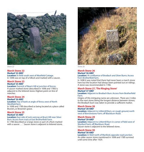
Stone 22<br />
<strong>March</strong> Stone 22<br />
Marked ‘22 ABD’<br />
Location: In field south west of Westfield Cottage.<br />
In 1698 was on top of a hillock and marked with a saucer.<br />
<strong>March</strong> Stone 23<br />
Marked ‘23 ABD’<br />
Location: Summit of Bean’s Hill at junction of fences.<br />
A saucer marked stone (described in 1698 and 1780) is<br />
adjacent to the lettered stone. Highest point on line of<br />
marches.<br />
<strong>March</strong> Stone 24<br />
Marked ‘24 ABD’<br />
Location: Top of bank at angle of fence, west of North<br />
Westfield farm.<br />
In 1698 and 1780 described as being located at a place called<br />
Brunie’s, or Brownie’s grave.<br />
<strong>March</strong> Stone 25<br />
Marked ‘25 ABD’<br />
Location: East side of rock outcrop at Brunt Hill near Silver<br />
Burn. Access from track at East Brotherfield Farm.<br />
In 1780 described as ‘a large stone or part of a Rock marked<br />
with a saucer. . . ’ Saucer stone is adjacent to lettered stone.<br />
Stone 26<br />
<strong>March</strong> Stone 26<br />
Marked ‘26 ABD’<br />
Location: At confluence of Brodiach and Silver Burns. Access<br />
from Brotherfield farm.<br />
In 1698 it was noted that there had never been a march stone<br />
here but the location had always been pointed out on ridings.<br />
A stone was recommended in 1780.<br />
<strong>March</strong> Stone 27, ‘The Ringing Stone’<br />
Marked ‘27 ABD’<br />
Location: Adjacent to Brodiach Burn. Access from Brotherfield<br />
Farm.<br />
Origins of this intriguing name are unknown. There are 2 miles<br />
to the next stone, being the longest distance between stones;<br />
the Brodiach burn was taken to provide a sufficient marker.<br />
<strong>March</strong> Stone 28<br />
Marked ‘28 ABD’<br />
Location: Adjacent to Littlemill Burn, on rough ground, north<br />
west of Borrowstone Farm, off Blackburn Road.<br />
<strong>March</strong> Stone 29<br />
Marked ‘29 ABD’<br />
Location: Adjacent to Littlemill Burn in corner of field west of<br />
Wynford Farm, off Blackburn Road.<br />
Saucer stone is adjacent to the lettered stone.<br />
<strong>March</strong> Stone 30<br />
Marked ‘30 ABD’<br />
Location: In field north of Wynford, opposite road junction.<br />
An older saucer stone mentioned in 1698 and 1780 survived<br />
until some time after 1929.