

THE NEVADA TRAVERSE - Nevada Association of Land Surveyors
THE NEVADA TRAVERSE - Nevada Association of Land Surveyors
THE NEVADA TRAVERSE - Nevada Association of Land Surveyors

Create successful ePaper yourself
Turn your PDF publications into a flip-book with our unique Google optimized e-Paper software.
The <strong>Nevada</strong><br />
Traverse<br />
Institutional Affiliate<br />
National Society <strong>of</strong> Pr<strong>of</strong>essional <strong>Surveyors</strong><br />
Member Western Federation <strong>of</strong> Pr<strong>of</strong>essional <strong>Surveyors</strong><br />
Vol. 39, No. 2 Journal <strong>of</strong> the Pr<strong>of</strong>essional <strong>Land</strong> <strong>Surveyors</strong> <strong>of</strong> <strong>Nevada</strong> 2012<br />
Terra Incognita - Surveying On New Spain’s<br />
Northern Frontier Part I ... See Page 5<br />
2012 CLSA/NALS Joint Conference Wrap-up... See Page 10
Who’s Who in NALS<br />
2012 State <strong>Association</strong> Officers Lahontan Chapter<br />
Ray Hebert, PLS, President<br />
Tri State Surveying, Ltd. Bus. 775- 358-9491<br />
1925 E. Prater Way Fax: 775-358-3664<br />
Sparks, NV 89434<br />
Email: rhebert@tristateltd.com<br />
Vern Little, PLS, President-Elect<br />
VTN <strong>Nevada</strong> Bus. 702- 873-7550<br />
2727 S. Rainbow Blvd. Fax: 702-362-2597<br />
Las Vegas, NV 89102<br />
Email: vernl@vtnnv.com<br />
Glen Armstrong, PLS, Secretary<br />
U.S. Geomatics, Inc. Bus. 775- 786-5111<br />
227 Vine Street Fax: 775-786-5114<br />
Reno, NV 89503<br />
Email: garmstrong@usgeomatics.com<br />
Trent Keenan, PLS, Treasurer<br />
Diamondback <strong>Land</strong> Surveying, LLC Bus. 702-823-3257<br />
1091 Cimarron Road, Suite A1 Fax: 702-933-9030<br />
Las Vegas, NV 89145<br />
Email: tkeenan@diamondbacklandsurveying.com<br />
The <strong>Nevada</strong> Traverse<br />
Terry W. McHenry, PLS, Editor, The <strong>Nevada</strong> Traverse<br />
14710 Rancheros Drive Bus/Fax: 775.852.7290<br />
Reno, NV 89521<br />
Email: editornvtraverse@sbcglobal.net<br />
Central Office<br />
Executive Secretary position is currently vacant<br />
P.O. Box 20522 Bus: 775.624.6257<br />
Reno, NV 89515 Fax: 775.624.6257<br />
Contact Individual Board Members (above)<br />
NSPS Governor for <strong>Nevada</strong><br />
Paul Burn, PLS<br />
G.C. Wallace, Inc. Bus. 702.804.2060<br />
1555 South Rainbow Blvd. Fax: 702.804.2299<br />
Las Vegas, NV 89146<br />
Email: PBurn@gcwallace.com<br />
Great Basin Chapter<br />
Mailing Address: P.O. Box 944, Elko, NV 89803<br />
Carl C. deBaca, PLS, President and Chapter Representative<br />
Alidade, Inc. Bus. 775- 777-8587<br />
P.O. Box 1586 Fax: 775-777-8587<br />
Elko, NV 89803<br />
Email: alidade.nv@sbcglobal.net<br />
Norman M. Rockwell, PE, PLS, President-Elect<br />
Bureau <strong>of</strong> <strong>Land</strong> Management Bus. 775- 753-0321<br />
3900 E. Idaho Street Fax: 775-753-0246<br />
Elko, NV 89801<br />
Email: nrockwell@nv.blm.gov<br />
John Grange, PLS, Secretary<br />
Grange Surveying, Inc. Bus. 775-753-3610<br />
218 Holyoke Drive<br />
Spring Creek, NV 89815<br />
Email: jgrange2001@yahoo.com<br />
Bill Nisbet, PLS, Treasurer<br />
Chilton Engineering Bus. 775- 738-2121<br />
421 Court Street Fax: 775-738-7995<br />
Elko, NV 89801<br />
Email: wnisbet@chilton-inc.com<br />
Mailing Address: P.O. Box 20522, Reno, NV 89515<br />
David Crook, PLS, President & Chapter Representative<br />
Tri State Surveying, Ltd. Bus. 775- 358-9491<br />
1925 E. Prater Way<br />
Sparks, NV 89434<br />
Email: dcrook@tristateltd.com<br />
Jason Caster, PLS, President-Elect<br />
Wood Rodgers Bus. 775- 823-4068<br />
575 Double Eagle Court<br />
Reno, NV 89521<br />
Email: jcaster@woodrodgers.com<br />
Kevin German, PLS, Secretary<br />
CFA, Inc. Bus. 775- 856-1150<br />
1150 Corporate Blvd.<br />
Reno, NV 89502<br />
Email: kgerman@cfareno.com<br />
Halana Salazar, PLS, Treasurer<br />
NDOT Bus. 775- 888-7470<br />
1263 S. Stewart St.<br />
Carson City, NV 89712<br />
Email: hsalazar@dot.state.nv.us<br />
James Bedard, PLS, Chapter Representative<br />
Stantec Consulting Bus. 775- 398-1211<br />
6980 Sierra Center Parkway, Ste. 100 Fax: 775-850-0787<br />
Reno, NV 89511<br />
Email: james.bedard@stantec.com<br />
Southern <strong>Nevada</strong> Chapter<br />
Mailing Address: P.O. Box 572152, Las Vegas, NV 89157<br />
Alan Dill, PLS, President and Chapter Representative<br />
Stanley Consultants, Inc. Bus. 702-534-2150<br />
5820 S. Eastern Ave., Suite 200 Fax: 702-348-8364<br />
Las Vegas, NV 89119<br />
Email: dillalan@stanleygroup.com<br />
Gary Hancock, PLS, President-Elect<br />
City <strong>of</strong> North Las Vegas Bus. 702-633-1310<br />
50 East Brooks Ave. Fax: 702-633-1909<br />
North Las Vegas, NV 89030<br />
Email: hancockg@city<strong>of</strong>northlasvegas.com<br />
Sean Corkhill, PLS, Secretary<br />
Las Vegas Valley Water District Bus. 702-875-7074<br />
100 City Parkway, Suite 700 Fax: 702-822-3350<br />
Las Vegas, NV 89106<br />
Email: sean.corkill@lvvwd.com<br />
Jonathan Wooten, PLS, Treasurer<br />
Las Vegas Valley Water District Bus. 702-875-7075<br />
100 City Parkway, Suite 700 Fax: 702-822-3350<br />
Las Vegas, NV 89106<br />
Email: jon.wooten@lvvwd.com<br />
WFPS Delegates from <strong>Nevada</strong><br />
Nancy Almanzan, PLS<br />
City <strong>of</strong> Las Vegas Bus: 702.229.6343<br />
333 N. Rancho Dr. Fax: 702.804.8582<br />
Las Vegas, NV 89106<br />
Email: nalmanzan@lasvegasnevada.gov<br />
Matt Gingerich, PLS<br />
NVEnergy Bus: 775.834.4567<br />
PO Box 10100 S4B2O Fax: 775.834.4189<br />
Reno, NV 89520<br />
Email: mgingerich@nvenergy.com
This publication is issued quarterly by the <strong>Nevada</strong> <strong>Association</strong> <strong>of</strong> <strong>Land</strong><br />
<strong>Surveyors</strong> (NALS) and is published as a service to the <strong>Land</strong> Surveying pr<strong>of</strong>ession<br />
<strong>of</strong> the state <strong>of</strong> <strong>Nevada</strong>. The <strong>Nevada</strong> Traverse is an open forum for<br />
all surveyors, with an editorial policy predicated on the objective <strong>of</strong> NALS<br />
Constitution and Bylaws, Article II, which reads:<br />
“The purpose <strong>of</strong> this association shall be to promote the common good and<br />
welfare <strong>of</strong> its members in their activities in the pr<strong>of</strong>ession <strong>of</strong> <strong>Land</strong> Surveying; to<br />
promote and maintain the highest possible standards <strong>of</strong> pr<strong>of</strong>essional ethics and<br />
practice; to promote pr<strong>of</strong>essional uniformity; to promote public awareness and<br />
trust in Pr<strong>of</strong>essional <strong>Land</strong> <strong>Surveyors</strong> and their work.<br />
This organization, in its activities and in its membership, shall be non-political, nonpartisan,<br />
non-sectarian, and non-discriminatory.”<br />
The publication is mailed to NALS members and similar organizations on a complimentary<br />
basis. The <strong>Nevada</strong> Traverse is not copyright protected. Articles, except<br />
where specifically copyright noted, may be reprinted with proper credit. Written<br />
permission to reprint copyrighted material must be secured either from the author<br />
directly, or through the editor.<br />
Articles appearing in the publication do not necessarily reflect the viewpoints <strong>of</strong><br />
NALS, its <strong>of</strong>ficers, Board <strong>of</strong> Directors, or the editor, but are published as a service<br />
to its members, the general public, and for the betterment <strong>of</strong> the surveying<br />
pr<strong>of</strong>ession. No responsibility is assumed for errors, misquotes, or deletions as<br />
to its contents.<br />
Advertising Policy<br />
(Effective January 1, 2012)<br />
The <strong>Nevada</strong> Traverse is published quarterly by the <strong>Nevada</strong> <strong>Association</strong> <strong>of</strong> <strong>Land</strong><br />
<strong>Surveyors</strong> and accepts advertising. Contact the editor for submittal specifications<br />
for advertisements. The rates per issue are as follows:<br />
B&W Adv. Sizes/<br />
Types/Placement<br />
COLOR Adv. Sizes/Types/Placement<br />
The <strong>Nevada</strong> Traverse<br />
MEMBER NON-MEMBER<br />
PRICE PRICE<br />
1 Issue Yearly (4x) 1 Issue Yearly (4x)<br />
Pr<strong>of</strong>’l Listing $70.00 $165.00 $265.00 $525.00<br />
1/8 Page $100.00 $305.00 $295.00 $615.00<br />
1/4 Page $175.00 $525.00 $345.00 $965.00<br />
1/2 Pg (horiz or vert) $240.00 $730.00 $430.00 $1180.00<br />
3/4 Page $315.00 $950.00 $505.00 $1310.00<br />
Full Page $350.00 $1045.00 $540.00 $1530.00<br />
Center Spread (full<br />
pages ONLY)<br />
Inside L OR R face $610.00 $1745.00 $890.00 $2225.00<br />
Inside L AND R face $1020.00 $2940.00 $1530.00 $3875.00<br />
Outside L OR R face $560.00 $1580.00 $840.00 $2100.00<br />
Next 2 Spreads Out<br />
from Center<br />
1/4 Page $290.00 $770.00 $485.00 $1340.00<br />
1/2 Pg (horiz or vert) $400.00 $1080.00 $610.00 $1615.00<br />
Full Page $560.00 $1580.00 $840.00 $2100.00<br />
Cover (full pages ONLY<br />
except as noted)<br />
Inside front cover $640.00 $1855.00 $990.00 $2790.00<br />
Inside back cover $600.00 $1810.00 $930.00 $2375.00<br />
Outside back cover<br />
(3/4 page ONLY) $580.00 $1740.00 $1000.00 $2442.00<br />
Deadlines for submittals are the middle <strong>of</strong> January, April, July, and October.<br />
Business cards <strong>of</strong> the members will be published in each issue unless otherwise<br />
requested.<br />
Running an ad does not imply endorsement <strong>of</strong> that advertiser by NALS, and<br />
the editor reserves the right to not accept ads which may be in poor taste or<br />
objectionable to the policies <strong>of</strong> NALS.<br />
Send ad requests to:<br />
Terry W. McHenry, P.L.S.<br />
Editor, The <strong>Nevada</strong> Traverse<br />
14710 Rancheros Drive, Reno, NV 89521<br />
Phone/fax: 775-852-7290<br />
email: editornvtraverse@sbcglobal.net<br />
2 The <strong>Nevada</strong> Traverse Vol. 39, No. 2, 2012<br />
The<br />
Editor’s<br />
Corner<br />
by Terry W. McHenry, PLS<br />
2012 CLSA/NALS Joint Conference<br />
The March 2012 joint conference with California was a<br />
grand success in every sense <strong>of</strong> the word. Attendance was<br />
up from recent years, the scholarship auction set new<br />
records, the speakers and presentations were all top-notch,<br />
and the facilities at the Silver Legacy Hotel and Casino in<br />
Reno were a perfect fit for our needs. Details and statistics<br />
<strong>of</strong> the conference will be found in our President’s Report<br />
on Page 4, and in the Conference Wrap-up by Carl C.<br />
deBaca in the center section <strong>of</strong> this issue <strong>of</strong> The <strong>Nevada</strong><br />
Traverse. Accompanying the Wrap-up on the conference<br />
is an extensive photo collage, a listing <strong>of</strong> the conference<br />
sponsors, scholarship donors and purchasers, and NALS<br />
award winners for 2011, with photos. There is a full page<br />
copy <strong>of</strong> the <strong>Nevada</strong> Pr<strong>of</strong>essional <strong>Land</strong> <strong>Surveyors</strong> Week<br />
Proclamation issued by Governor Brian Sandoval, which<br />
CONTINUED ON NEXT PAGE u<br />
Table Of Contents<br />
The Editor’s Corner . . . . . . . . . . . . . . . . . . . . . . . . . . .2<br />
About the Cover . . . . . . . . . . . . . . . . . . . . . . . . . . . . . .3<br />
The President’s Report . . . . . . . . . . . . . . . . . . . . . . . .4<br />
Boundary Relic Has a New Home . . . . . . . . . . . . . . . .6<br />
Terra Incognita Surveying On New Spain’s Northern<br />
Frontier Part I . . . . . . . . . . . . . . . . . . . . . . . . . . . . . . . .5<br />
2012 CLSA/NALS Joint Conference Wrap-up . . . . . .10<br />
Conference Photo Gallery . . . . . . . . . . . . . . . . . . 11-16<br />
2012 CLSA/NALS Conference Conference Sponsors<br />
Scholarship Auction Donors and Purchasers . . . . . .17<br />
<strong>Nevada</strong>’s Four Year Degree Surveying/Geomatics<br />
Program Part III . . . . . . . . . . . . . . . . . . . . . . . . . . . . .18<br />
Sustaining Members . . . . . . . . . . . . . . . . . . . . . . . . .25<br />
Pr<strong>of</strong>essional Listings . . . . . . . . . . . . . . . . . . . . . . 28-29<br />
Lahontan Chapter Report . . . . . . . . . . . . . . . . . . . . .30<br />
Southern <strong>Nevada</strong> Chapter Report . . . . . . . . . . . . . . .30<br />
Great Basin Chapter Report . . . . . . . . . . . . . . . . . . .31<br />
Meeting Minutes, NALS BoD, 01/13/2012 . . . . . . . . .32<br />
BLM Accepted Surveys . . . . . . . . . . . . . . . . . . . . . . .33<br />
NSPS Report . . . . . . . . . . . . . . . . . . . . . . . . . . . . . . .34<br />
WFPS Report . . . . . . . . . . . . . . . . . . . . . . . . . . . . . .35<br />
NSPS Area 9 Director’s Report . . . . . . . . . . . . . . . . .36<br />
Governor’s Proclamation . . . . . . . . . . . . . . . . . . . . . .39<br />
Advertiser Index . . . . . . . . . . . . . . . . . . . . . . . . . . . . .44
The Editor’s Corner continued from previous page<br />
was read at the opening ceremonies <strong>of</strong> the conference.<br />
Don’t forget! Next year, this grand event will be repeated<br />
March 23-27, 2013, again at the Silver Legacy Hotel<br />
and Casino in Reno, with the California <strong>Land</strong> <strong>Surveyors</strong><br />
<strong>Association</strong>. Mark your calendars.<br />
George Davidson Monument Rehabilitation Completed<br />
Dedicated in conjunction with the 2012 CLSA/NALS Joint<br />
Conference, the George Davidson 1872 granite column known<br />
as Verdi East Base, has reached its resting place. In this issue<br />
<strong>of</strong> The <strong>Nevada</strong> Traverse, Paul S. Pace, PLS, puts the finishing<br />
touches on a multi-year effort to preserve and memorialize the<br />
significant history behind Davidson’s work in Verdi, <strong>Nevada</strong>.<br />
Our cover photo for this issue serves as an introduction to the<br />
article written by Paul Pace, and entitled “Boundary Relic Has<br />
a New Home.” Paul’s tireless work on this project was in part a<br />
factor in his selection as the NALS Surveyor <strong>of</strong> the Year Award<br />
for 2011.<br />
National Society <strong>of</strong> Pr<strong>of</strong>essional <strong>Surveyors</strong> (NSPS)<br />
Update<br />
Encouraging news has recently come down from the national<br />
scene <strong>of</strong> NSPS, as a result <strong>of</strong> the latest spring meetings<br />
held in Charlotte, N.C., May 4-5, 2012. Our two national<br />
representatives each report to us on these significant meetings.<br />
First, Paul Burn, PLS, <strong>Nevada</strong>’s NSPS Governor, recounts<br />
for us the results from the perspective <strong>of</strong> <strong>Nevada</strong>’s NALS<br />
members, and individual practitioner representation at the<br />
national level. Next, our NSPS Area 9 (California, Hawaii<br />
and <strong>Nevada</strong>) Director, Carl C. deBaca, PLS, brings us his<br />
observations and evaluations from a more regional viewpoint,<br />
but nevertheless how the merger with ACSM (which is no<br />
longer an entity) and NSPS has progressed, and how the<br />
future <strong>of</strong> national representation and its commensurate dues<br />
structure is playing out. Be sure to read both <strong>of</strong> these reports,<br />
because while there is some overlapping, the information is<br />
<strong>of</strong> such importance that it is good to grasp the perspectives <strong>of</strong><br />
both <strong>of</strong> our dedicated representatives.<br />
Great Basin College Survey/Geomatics Program, Part III<br />
Dr. James A. Elithorp, Ph.D., PLS, head <strong>of</strong> the GBC <strong>Land</strong><br />
Surveying/Geomatics Program in Elko, <strong>Nevada</strong>, brings to<br />
the readers <strong>of</strong> The <strong>Nevada</strong> Traverse the third installment<br />
<strong>of</strong> a multi-part series on <strong>Nevada</strong>’s only four year degree<br />
program in land surveying. In this particular article he covers<br />
Preparation for Study in <strong>Nevada</strong>’s Online Four-Year<br />
Degree Program.<br />
This Editor had the privilege to meet and dialogue with Dr.<br />
Elithorp during the recent CLSA/NALS Conference regarding<br />
the unique program at GBC. As practitioners in <strong>Nevada</strong><br />
we need to understand the full implications <strong>of</strong> what this<br />
program <strong>of</strong>fers, and to be supportive in these times <strong>of</strong> economic<br />
hardships and dwindling student enrollments, not to mention<br />
scrutiny <strong>of</strong> college program student head count. Dr. Elithorp<br />
has developed a very unique program here in <strong>Nevada</strong>, probably<br />
the only one <strong>of</strong> its kind nationally. He is dedicated to meeting<br />
the unique needs <strong>of</strong> not only <strong>Nevada</strong> students, many <strong>of</strong> whom<br />
are simultaneously working while pursuing their degrees, but<br />
also to out <strong>of</strong> state students, who account for a large percentage<br />
<strong>of</strong> the program’s enrollees.<br />
Terra Incognita, Part I<br />
With this issue <strong>of</strong> The <strong>Nevada</strong> Traverse we introduce another<br />
<strong>of</strong> Paul Pace’s historical research projects, this time 16 th<br />
Century exploration and mapping on the northern frontiers<br />
<strong>of</strong> South America, which eventually made its way up and into<br />
the southern areas <strong>of</strong> North America. Aptly entitled Terra<br />
Incognita, Surveying on New Spain’s Northern Frontier,<br />
join Paul once again as he takes us back in time to some roots<br />
<strong>of</strong> our heritage as land surveyors and explorers. Part II will<br />
appear in the next issue <strong>of</strong> The <strong>Nevada</strong> Traverse.<br />
About the Cover<br />
by Terry W. McHenry, PLS<br />
U<br />
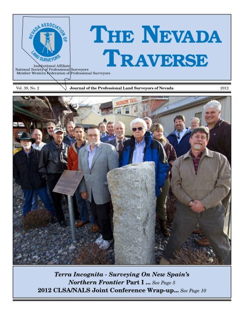
The cover photo for this issue <strong>of</strong> The <strong>Nevada</strong> Traverse was<br />
taken March 27, 2012 by Steve Shambeck, PLS, <strong>of</strong> PLS<br />
Photography. The occasion was the formal dedication <strong>of</strong> the<br />
1872 George Davidson monument, Verdi East Base, and<br />
its rehabilitation and relocation in Boomtown, at the front<br />
entrance <strong>of</strong> the Boomtown Hotel and Casino in Verdi, <strong>Nevada</strong>.<br />
The dedication was conducted March 27, 2012 in conjunction<br />
with the 2012 CLSA/NALS Joint Conference and Exhibition<br />
held at the Silver Legacy Hotel and Casino in downtown Reno,<br />
<strong>Nevada</strong>. A large number <strong>of</strong> conference attendees from <strong>Nevada</strong><br />
and California attended the dedication ceremony, many <strong>of</strong><br />
whom were contributors and supporters <strong>of</strong> the monument’s<br />
preservation effort.<br />
Please refer to the article entitled “Boundary Relic Has<br />
a New Home,” by Paul S. Pace, PLS, in this issue <strong>of</strong> The<br />
<strong>Nevada</strong> Traverse. Paul Pace who took the lead on this effort a<br />
number <strong>of</strong> years ago, and was the primary motivator behind a<br />
successful completion.<br />
The individual on the left, back row is Paul Pace (with<br />
sunglasses). Also a few others who were significant<br />
contributors to the effort were Matt Gingerich, PLS, third from<br />
right, back row; Aaron Smith, PLS, <strong>of</strong> CLSA, furthest right;<br />
and Steve Parrish, PLS, standing between the granite column<br />
and the plaque.<br />
U<br />
The <strong>Nevada</strong> Traverse Vol. 39, No. 2, 2012 3
The<br />
President’s<br />
Report<br />
by<br />
Raymond R. Hebert, PLS<br />
I would like to thank all <strong>of</strong> you for a great 1 st Quarter.<br />
The <strong>Nevada</strong> Traverse went out as an “all surveyor’s” issue<br />
March 1, 2012, on time and along with some poignant articles<br />
gathered by our illustrious editor and chief, Terry McHenry.<br />
Now that the board is in its respective place for the year I<br />
would like to thank you all for your hard work. While there<br />
are a few hiccups in the runnings without an Executive<br />
Secretary, most issues have been worked out and have set<br />
the underpinnings <strong>of</strong> a new beginning. Trent Keenan and<br />
Terry McHenry have combined efforts to sort out the data<br />
base issues and migrate to an Excel format. For the 2012<br />
year, an effort is underway to clean up long standing issues<br />
with the last inherited reporting system. Trent disbursed the<br />
funds to the local chapters in early March. The tax forms for<br />
the organization are virtually finished by J&W Enterprises<br />
(Trent’s Accountant) at a fee <strong>of</strong> $750, with no resulting tax<br />
payment necessary. Vern Little has, with the help <strong>of</strong> Chris<br />
Marini, migrated the website to Network Savants. It is my<br />
understanding that Vern is trying to work out a way to upgrade<br />
the site and/or re-write the script to allow for placement <strong>of</strong> past<br />
issues <strong>of</strong> The <strong>Nevada</strong> Traverse as a historical data base. Glen<br />
Armstrong has filed with the Secretary <strong>of</strong> State a current list<br />
<strong>of</strong> <strong>Association</strong> <strong>of</strong>ficers.<br />
Major kudos go out to Dorothy, Crissy and Nancy for<br />
putting on a near flawless conference at the Silver Legacy.<br />
The Executive Board has reviewed and signed an MOU for<br />
2013 with CLSA to repeat the performance at the Silver<br />
Legacy next year. The 2012 conference was well attended<br />
by approximately 500 attendees; 33 percent were <strong>Nevada</strong><br />
personnel. Approximately 46 sessions were held addressing<br />
LS Review, easements, Technology, Geodesy, Boundary, <strong>Nevada</strong><br />
and California Law, zoning, communication, NV and CA state<br />
boards, FEMA, subsidence, water rights, solar, business and,<br />
topped <strong>of</strong>f with a wonderful presentation <strong>of</strong> a Mock Trial,<br />
scripted by Gary Kent and featuring a real judge and attorneys,<br />
with the following cast <strong>of</strong> players: the Honorable David Hardy,<br />
2 nd Judicial District Court, Michelle Stone and Agnes Hanley<br />
from Chapman law firm, Curt Chapman, Carl C. de Baca,<br />
Armond Marois and Matt Vernon. I can hardly wait for next<br />
year. The NALS scholarship Auction netted in the area <strong>of</strong><br />
$16K, which is a new benchmark for our association.<br />
As you all are aware we owe many “thanks” to Marty and<br />
Rhonda for being the driving forces behind funding, and finding<br />
and repairing instrumentation to be sold on behalf <strong>of</strong> the<br />
students. Added to the NSPS Foundation we have the following<br />
amounts to draw from for our students: 1) NALS Endowment<br />
Account $72,741.47(can use $7,741.47); 2) NALS Scholarship<br />
Account $38,826.53(can use $3,826.53);3) NALS Equipment<br />
Account $29,672.19; 4) Tom Foote Scholarship Fund $10,220.<br />
Consideration is being given to distributing the $16K so that<br />
we can support our GBC College program, and Scholarship<br />
Account. In addition to this amount the Monsen Scholarship<br />
was upped to $2,000 for the next deserving student.<br />
It is my understanding that all three local chapters have been<br />
active and have had a cross-section <strong>of</strong> excellent speakers,<br />
drawing members to meetings in the neighborhood <strong>of</strong> 30-40 for<br />
4 The <strong>Nevada</strong> Traverse Vol. 39, No. 2, 2012<br />
Photo by Steve Shambeck<br />
Lahontan and Southern Chapters, and 10-15 attendees to the<br />
Great Basin Chapter. Thank you to the local chapters, and keep<br />
up the good work.<br />
Education wise, Trigstar and Career Days are drumming the<br />
beat <strong>of</strong> getting students interested in surveying as a pr<strong>of</strong>ession.<br />
Collectively, Trigstar has presented the examination to<br />
approximately 350 students north, south and east in <strong>Nevada</strong>.<br />
Career Day presentations have presented to approximately<br />
1400 students in Las Vegas area, 200 students in the Reno area<br />
and about 100 students in the Elko area. Needless to say we<br />
need to continue to search out opportunities <strong>of</strong> exposure to land<br />
surveying as a viable pr<strong>of</strong>ession, given that ours is an aging<br />
pr<strong>of</strong>ession with declining numbers <strong>of</strong> licensees, coupled with<br />
the affects <strong>of</strong> supply and demand. Thank you to all that are<br />
participating.<br />
The NALS Board is currently exploring two possible venues<br />
<strong>of</strong> presentation this fall to support PDH requirements: 1) A<br />
Round Table on RS2477 (Brett Lane and Steve Parrish), and 2)<br />
NRS and Subdivision Map Act (Michael Kidd). Speak up if you<br />
know <strong>of</strong> other opportunities for PDH credits.<br />
Membership wise we are sitting at about 200 members strong.<br />
The following is an approximate breakdown: 70 Southern<br />
Chapter Members; 58 Lahontan Chapter Members; 9 Great<br />
Basin Chapter Members; 11 LSI Members; 4 Corresponding<br />
Members and 3 Associate Members. The balance <strong>of</strong> membership<br />
is made up <strong>of</strong> sustaining members and student members.<br />
NALS Lapel Pins and Shirts are for sale, along with other<br />
items. See the back pages <strong>of</strong> The <strong>Nevada</strong> Traverse for the<br />
recently revised order form.<br />
Legislatively, we are in an <strong>of</strong>f year. Brett Lane has encouraged<br />
the Board to stay vigilant regarding review <strong>of</strong> upcoming<br />
legislation for the 2013 legislative session. Brett encouraged<br />
the chapters to discuss with their legislative chairs any<br />
proposed legislation <strong>of</strong> concern. NALS will soon be opening<br />
dialog with Bruce Arkell for lobbying services for the 2013<br />
Session.<br />
The Davidson monument was <strong>of</strong>ficially “Christened” on the<br />
north side <strong>of</strong> Boomtown Casino. The monument and plaque<br />
lie in a fenced <strong>of</strong>f area along side <strong>of</strong> a period bronze horse and<br />
cowboy (how fitting). A group <strong>of</strong> approximately 75 people from<br />
the NALS/CLSA Conference attended the event, which included<br />
board members from both associations, plus the Boomtown<br />
manager, with Paul Pace presiding.<br />
We were well represented at the recent Western Federation <strong>of</strong><br />
Pr<strong>of</strong>essional <strong>Surveyors</strong> meeting, as Nancy Almanzan and Matt<br />
Gingerich attended. It is interesting to note the membership<br />
status for each <strong>of</strong> the 14 states, as well as CLSA’s direction<br />
towards a PDH requirement.<br />
NSPS is in the throes <strong>of</strong> assimilating ACSM. In doing so,<br />
we may be looking at a re-structuring <strong>of</strong> the dues in terms <strong>of</strong><br />
affiliation with the national organization. Paul Burn and Carl<br />
C. deBaca are keeping a close watch on this process. NALS is<br />
working on how to address this change as it affects <strong>Nevada</strong>.<br />
Dialogue on this matter will be continuing. See the latest NSPS<br />
Report in this issue <strong>of</strong> The <strong>Nevada</strong> Traverse, from our <strong>Nevada</strong><br />
NSPS Governor, Paul Burn, PLS.<br />
The next NALS Board <strong>of</strong> Directors meeting will be held in Elko<br />
on Friday, July 20th , 2012. I ask that everyone plan accordingly,<br />
and try to attend the Great Basin Chapter picnic the following<br />
day, Saturday, in support <strong>of</strong> your eastern chapter.<br />
U
Terra Incognita<br />
Surveying On New Spain’s<br />
Northern Frontier Part I<br />
by Paul S. Pace, PLS<br />
T<br />
(End Notes begin on Page 40)<br />
he Age <strong>of</strong> Discovery, <strong>of</strong>ten called the Age <strong>of</strong> Exploration,<br />
quickly became as well an age <strong>of</strong> colonialism. In the<br />
New World, European monarchies including Holland,<br />
England, France, Portugal, Spain and later Russia all vied for<br />
land in the Americas. So quickly did the rush for territories in<br />
the New World occur that beginning as soon as 1493 a series<br />
<strong>of</strong> papal decrees and treaties1 between Spain and Portugal<br />
were written to demark ownership. Based on longitudes no one<br />
could accurately determine, and confused with differing units<br />
<strong>of</strong> measure, these treaties were intended to relieve tensions<br />
regarding title to the new lands.<br />
Portugal eventually won control over millions <strong>of</strong> square miles<br />
in South America, creating Brazil, now the 5th largest country<br />
in the world. 2 Apart from territories claimed by England and<br />
France, Spain took the bulk <strong>of</strong> the New World. In the process<br />
she became a superpower, demolishing otherwise advanced and<br />
sophisticated civilizations and creating one <strong>of</strong> the largest empires<br />
the world had ever seen. By the middle <strong>of</strong> the 16th Century she<br />
had subjugated vast stretches <strong>of</strong> the three American continents,<br />
wasting little time exploiting the land and the indigenous<br />
peoples there to her advantage. After Spain’s conquest, <strong>of</strong>ten<br />
seen as a lethal mix <strong>of</strong> gold rush and religious zealotry, came a<br />
dramatic demographic collapse 3 and the inexorable latinization<br />
<strong>of</strong> the Americas.<br />
Vestiges <strong>of</strong> Spain’s vast empire are today widespread in the New<br />
World. Indeed, remnants from her American colonies appear<br />
throughout the globe, as do echoes from their exploitation and<br />
eventual collapse. Perhaps some <strong>of</strong> the more ubiquitous, more<br />
tangible symbols <strong>of</strong> Spain’s American empire were the eight<br />
reale silver coins, the famous “pieces <strong>of</strong> eight”. Coined in their<br />
millions from the mines <strong>of</strong> New Spain and above all, Potosí, the<br />
Silver Mountain in what is now Bolivia, they are found to this<br />
day virtually around the world. The torrent <strong>of</strong> silver from Spain’s<br />
American colonies began as a trickle <strong>of</strong> 326 pounds in the 1520’s.<br />
It grew to 661,000 pounds in the 1550’s and over 6,000,000<br />
pounds by the 1590’s. 4 By the 1570’s the coins were minted in the<br />
Americas and shipped then to Spain, the Philippines and all the<br />
other Spanish colonies. And it was used universally, becoming<br />
the world’s first truly global currency. Widely circulated in the<br />
United States, the reale was legal tender here until 1857. 5<br />
The human cost <strong>of</strong> mining those quantities <strong>of</strong> silver was fearful.<br />
Located at 13,000 feet above the sea in the severe Andean<br />
climate, the mines at Potosí employed the forced labor <strong>of</strong> the<br />
indigenous population. When the Indians died in ever increasing<br />
numbers, African slaves were imported to continue mining.<br />
They died as well. So much silver was produced that it had a<br />
major impact on world economies. Importing ever more silver,<br />
while hemorrhaging pieces <strong>of</strong> eight to finance her endless wars<br />
and growing colonial empire, Spain ultimately faced economic<br />
hardship from the resulting deflation <strong>of</strong> the reale. Despite the<br />
flow <strong>of</strong> silver, she was unable to generate enough revenue to pay<br />
her enormous armies; Spain was forced to declare bankruptcy in<br />
1575 and again in 1595.<br />
But discoveries in the Age <strong>of</strong> Exploration contributed in other,<br />
less lethal ways. In fact, the<br />
CONTINUED ON PAGE 8 u<br />
The <strong>Nevada</strong> Traverse Vol. 39, No. 2, 2012 5
Boundary Relic Has<br />
a New Home<br />
By Paul S. Pace, PLS<br />
The granite column known as the Davidson Monument got<br />
its new home near the front entrance <strong>of</strong> Boomtown Hotel and<br />
Casino in Verdi, <strong>Nevada</strong> in the Spring <strong>of</strong> 2011. Volunteers from<br />
NVEnergy moved the column from its storage location to the<br />
new location near the front entrance to the Boomtown complex.<br />
Verdi East Base in place on a ranch in Verdi, <strong>Nevada</strong>, in the late<br />
1980’s. Photo by author<br />
NVEnergy volunteers set the column in its new location at Boomtown April,<br />
2011. Photo by author.<br />
In the Fall <strong>of</strong> 2011 a party <strong>of</strong> NALS and CLSA members retied<br />
the column into Davidson’s original 1872 triangulation network<br />
near the 120th Meridian. The column perpetuated the eastern<br />
terminus <strong>of</strong> Davidson’s taped base line, Verdi East Base. An<br />
interpretive plaque and a brass disk, set in the drill hole in the<br />
6 The <strong>Nevada</strong> Traverse Vol. 39, No. 2, 2012<br />
top <strong>of</strong> the column, were in place by the end <strong>of</strong> the year. During<br />
this year’s CLSA-NALS Joint Conference, a brief dedication<br />
ceremony was held after the Conference sessions on March<br />
27, 2012, to highlight the monument’s new venue. The event<br />
was well attended by NALS and CLSA members, as well as<br />
others interested in the state boundary surveys. It was the<br />
culmination <strong>of</strong> years <strong>of</strong> effort by the two state associations,<br />
Boomtown and others with a passion for history.<br />
Former NALS President Matt Gingerich, PLS at Davidson’s<br />
Point <strong>of</strong> Rocks, during the survey in October, 2001. Photo by author.<br />
Some <strong>of</strong> the NALS and CLSA members attending the dedication<br />
at Boomtown, March 27th, 2012. Photo by Steve Shambeck, PLS<br />
Photography<br />
CONTINUED ON NEXT PAGE u
Boundary Relic.. continued from previous page<br />
The brass plaque produced by Berntsen and set adjacent to the<br />
Davidson Monument. Photo by author<br />
Record <strong>of</strong> Survey map perpetuating the Davidson Monument filed in<br />
Washoe County, March 2012<br />
“You will miss<br />
everything you don’t<br />
aim for.”<br />
- The Mastermind<br />
Has Your Contact<br />
Information Changed?<br />
Change in your address,<br />
email address, or telephone?<br />
Please contact NALS with<br />
your updated information.<br />
You may email Glen Armstrong, PLS<br />
NALS Secretary at:<br />
garmstrong@usgeomatics.com<br />
Help your NALS Board<br />
to keep you current.<br />
Thank you!<br />
The <strong>Nevada</strong> Traverse Vol. 39, No. 2, 2012 7
Terra Incognita.. continued from page 5<br />
Europeans were in the midst <strong>of</strong> discovering themselves, along<br />
with new and exotic lands, in an explosion <strong>of</strong> geography.<br />
Surveying was becoming an ever more accurate and reliable<br />
science and in doing so it brought cartography along with it.<br />
Thanks to rapidly improving printing techniques, map literacy<br />
improved. Europeans visualized their changing world in new<br />
and better ways. Still, until well into the 1700’s, and in some<br />
places the mid 1800’s, maps <strong>of</strong> vast reaches <strong>of</strong> the Americas were<br />
<strong>of</strong>ten more the product <strong>of</strong> fantasy than fact. The maps <strong>of</strong>ten<br />
depicted imaginary lands, rivers and seas, or left large areas <strong>of</strong><br />
empty paper. Much <strong>of</strong> it remained terra incognita, an unknown<br />
land, to all but its inhabitants.<br />
During Spain’s 16th Century colonial expansion, her monarch<br />
Philip II sponsored surveying and mapping projects in all his<br />
realms, the Americas in particular. He recognized, as the British<br />
later did in India, that cartography and imperialism go hand in<br />
hand. To merely claim a territory, one can do without maps, but<br />
to govern it requires knowledge and maps are the key. Philip’s<br />
cartographers in Madrid requested information from colonial<br />
and military <strong>of</strong>ficials regarding cities and towns, fortifications,<br />
prominent features, measured latitudes, data from indigenous<br />
peoples, etc. 6 Longitude however remained an unresolved<br />
problem. But one <strong>of</strong> the cartographers, López de Velasco, sent<br />
instructions to colonial <strong>of</strong>ficials in all <strong>of</strong> Spain’s territories to<br />
observe the lunar eclipses <strong>of</strong> September 26, 1577 and September<br />
15, 1578. It was an ambitious but perfectly functional plan to<br />
determine longitudes around Spain’s far flung empire. They<br />
were to observe the moon’s altitude above the horizon at the<br />
start and end <strong>of</strong> the eclipses 7 together with local times <strong>of</strong> the<br />
events, probably with a nocturnal. 8 Included in the instructions<br />
were plans for making simple instruments to observe these<br />
phenomena.<br />
From a comparison <strong>of</strong> the colonist’s lunar observations, against<br />
those he observed in Madrid, Valesco hoped to derive time<br />
differentials and construct longitudes. He could then assemble<br />
a great mosaic from the other geodetic and geographical data.<br />
The information sent back by local <strong>of</strong>ficials was <strong>of</strong> value, but<br />
the larger, state-sponsored surveys in New Spain were a<br />
failure. These and later eclipse-observation experiments, were<br />
inconsistent, 9 although longitude for Mexico City was finally<br />
derived. But mistakes had consequences; erroneous longitudes<br />
would effect the treaties <strong>of</strong> demarcation and could give Portugal<br />
still more land in the Americas at Spain’s expense.<br />
The tremendous flow <strong>of</strong> information, and continually updated<br />
means <strong>of</strong> gathering it, brought the rise <strong>of</strong> a new kind <strong>of</strong> multidisciplinary<br />
scientist, the Royal Cosmographer. Fusing all the<br />
incoming data into a coherent picture, this surveyor, astronomer,<br />
cartographer and general science advisor to the Spanish Court<br />
turned the collected observations into a vast body <strong>of</strong> knowledge<br />
which informed the King as he exerted his will over the empire.<br />
Juxtaposed to this enormous acquisition <strong>of</strong> new data was the<br />
intense need for secrecy. In 1481 the Portuguese monarchy<br />
imposed a prohibition on the dissemination <strong>of</strong> nautical maps<br />
and descriptions <strong>of</strong> explorations. Later it became illegal for<br />
foreign pilots to own Portuguese navigational or “portolan”<br />
charts. The Spanish Crown soon adopted the same mindset. The<br />
maps and descriptions <strong>of</strong> the New World were <strong>of</strong> great economic,<br />
strategic and political importance and as such became state<br />
secrets. 10 Royal Cosmographers, already tied to the monarch’s<br />
bureaucracy, were obliged to limit access to their work.<br />
In 1572 a new wave <strong>of</strong> Christian missionaries arrived in<br />
8 The <strong>Nevada</strong> Traverse Vol. 39, No. 2, 2012<br />
New Spain, augmenting those who landed earlier with the<br />
Conquistadores. Jesuit priests 11 from Europe began arriving in<br />
large numbers and soon opened one <strong>of</strong> the first universities in<br />
North America at Mexico City, sixty years before the founding<br />
<strong>of</strong> Harvard. Charged with the conversion and welfare <strong>of</strong> the<br />
Indians, they acculturated their system to the ways <strong>of</strong> those<br />
they sought to convert, paying particular attention to native<br />
languages. 12 They saw themselves as protection for Indian<br />
cultures against the devastation that military and colonial<br />
forces wrought on them during and after the Conquest. The<br />
areas under Jesuit control became semi-autonomous regions,<br />
independent <strong>of</strong> the secular government. This provoked tensions<br />
with the Spanish military and civil authority, who sought the<br />
continued exploitation <strong>of</strong> the Indian population as cheap labor<br />
or worse. 13 Disputes between Franciscan missionaries and civil<br />
government in New Mexico over the disposition <strong>of</strong> the Pueblo<br />
population were a contributing factor in the 1680 Pueblo Revolt,<br />
in which hundreds <strong>of</strong> Indians and Spaniards were killed.<br />
More or less concurrent with the arrival <strong>of</strong> the Jesuits in New<br />
Spain was the start <strong>of</strong> their efforts in China. 14 Accepted into the<br />
country by the last rulers <strong>of</strong> the Ming Dynasty, they exchanged<br />
information with Chinese scholars and demonstrated western<br />
scientific theories and instruments. European mathematical and<br />
scientific treatises were translated into Chinese and conversely,<br />
Chinese works into Latin. The missionaries argued to their<br />
western superiors that Chinese classics had core values and<br />
tenets that matched those <strong>of</strong> Christian Europe. When Galileo<br />
introduced his discoveries substantiating Copernicus’ heliocentric<br />
theories, French Jesuits quickly introduced Copernican<br />
theory to the Chinese and requested telescopes from Europe. 15<br />
They conducted surveying, mapping and astronomical work,<br />
including a 3900 mile traverse <strong>of</strong> the Great Wall, assisted in<br />
updating the Chinese calendar and the precise measurement<br />
<strong>of</strong> a meridional arc in an effort to better understand the shape<br />
<strong>of</strong> the earth and derive a consistent unit <strong>of</strong> measurement based<br />
on geodesy.<br />
Later, the imperial court requested formal mapping <strong>of</strong> the<br />
empire. From 1705 to 1759, the Jesuits engaged in three large<br />
surveying projects, using rigorous survey procedures. 16 From<br />
a prime meridian established at Beijing, a large triangulation<br />
network was built from long chains <strong>of</strong> triangles. They were among<br />
the first to adopt the use <strong>of</strong> triangulation rather than purely<br />
astronomical methods as a means <strong>of</strong> high-order location. 17 Base<br />
lines measured with long iron-wire chains, 18 while elevations<br />
in mountain ranges were developed trigonometrically. All<br />
the new field data, together with extensive existing Chinese<br />
cartographic and geodetic data dating back centuries, were<br />
rendered onto map projections. Maps were printed from wood<br />
cuts and engraved copper plates. In nearly all respects, the<br />
Jesuit’s rigorous surveys in China, conducted by about a dozen<br />
priests and a corps <strong>of</strong> talented Chinese surveyors, were a great<br />
success. 19<br />
By contrast, Spain’s financial commitment to the missionaries<br />
in New Spain was severely limited by ongoing fiscal crises. With<br />
the Crown in no position financially to support their work, the<br />
Jesuits resorted to private donations to fund their efforts. 20<br />
Particularly on the northern frontiers and the rugged Baja<br />
peninsula, early efforts to make their work among the Indians<br />
sustainable were difficult and expensive. In terms <strong>of</strong> exploration<br />
and surveying, theirs would have to be a reconnaissance at best.<br />
That would be adequate for the purposes but well below the skills<br />
CONTINUED ON NEXT PAGE u
Terra Incognita.. continued from previous page<br />
and intents <strong>of</strong> the personnel involved. A similar situation existed<br />
in New France (eastern Canada and much <strong>of</strong> the Mississippi<br />
River watershed in the U.S.), where missionaries like Jacques<br />
Marquette S.J. conducted lengthy explorations using a compass<br />
and an astrolabe. They produced some <strong>of</strong> the first accurate maps<br />
<strong>of</strong> the region, but lacked sufficient backing to continue the work.<br />
Eusebio Kino<br />
While there were several <strong>of</strong> these explorer-priests working on<br />
the frontiers <strong>of</strong> New Spain in the 17th Century, it is perhaps<br />
most useful to examine the work <strong>of</strong> the best documented <strong>of</strong><br />
them, Eusebio Kino, S.J. 21 Upon arriving in Mexico in May <strong>of</strong><br />
1681, he was named Royal Cosmographer. In that capacity, he<br />
accompanied two expeditions to Baja California in 1683-84. The<br />
first expedition failed quickly. But during a second attempt, they<br />
established, in typical Spanish fashion, a small presidio and<br />
mission at San Bruno, about 95 miles north <strong>of</strong> the present town<br />
<strong>of</strong> Loreto, on the eastern shore. Kino accompanied an expedition<br />
across Baja’s rugged interior to the Pacific, where he mapped<br />
a portion <strong>of</strong> the coast and took notice <strong>of</strong>, among other things,<br />
unique blue shells on the beach. He explored eastern Baja from<br />
San Bruno south to the bay at La Paz, and produced a map <strong>of</strong><br />
what he found. (Fig 1) A prolonged drought ended the effort.<br />
Figure 1. Kino’s 1683 <strong>of</strong> the eastern shore <strong>of</strong> Baja California<br />
The Spaniards made several unsuccessful attempts to colonize<br />
Baja California’s barren shores, first seen by Europeans in 1533.<br />
Hernán Cortés attempted to establish a colony there in 1535.<br />
That enterprise failed, but Cortés continued his explorations.<br />
In 1539 he sent one <strong>of</strong> his lieutenants Francisco Ulloa out with<br />
several ships to explore Baja, at the time still thought to be an<br />
island. They were in search <strong>of</strong> the Strait <strong>of</strong> Anian, the waters<br />
allegedly leading to the imagined Northwest Passage. Ulloa<br />
sailed to within sight <strong>of</strong> the head <strong>of</strong> the gulf and back, ending<br />
one would think, the notion <strong>of</strong> Baja as an island. If that weren’t<br />
enough, the following year Hernan de Alarcón again sailed to the<br />
head <strong>of</strong> the Gulf, braved the huge tidal bore at the mouth <strong>of</strong> the<br />
Colorado River and proceeded to sail upstream to the junction<br />
with the Gila River. Nevertheless, these efforts were trumped by<br />
the island concept, which persisted in one form or another until<br />
1820. The island <strong>of</strong> California remained on most maps.<br />
In 1542 Cabrillo explored the outer coast <strong>of</strong> Alta California<br />
beyond Cape Mendocino, in quest <strong>of</strong> the same Strait <strong>of</strong> Anian.<br />
(Fig 2) He missed San Francisco Bay on the way by, but came<br />
ashore at what is now San Diego, becoming the first European<br />
to set foot on the Pacific coast <strong>of</strong> what became the United States.<br />
Figure 2. Hugo Allards’s 1685 map depicting California as an<br />
island and the imagined Straight <strong>of</strong> Anian<br />
Following the conquest <strong>of</strong> the Philippines in the 1570’s, there<br />
was renewed interest in the Californias as an emergency stop for<br />
the Manila Galleon. The voyage was long and scurvy decimated<br />
crews and passengers alike, so a port <strong>of</strong> refuge on the voyage<br />
from Manila to Acapulco was envisioned. English privateers too,<br />
such as Drake and Cavendish, cruised the Pacific in search <strong>of</strong> the<br />
Galleon and her cargo <strong>of</strong> riches. Spanish <strong>of</strong>ficials believed the<br />
Californias would have to be explored, colonized, and fortified to<br />
ensure the safety <strong>of</strong> the Galleon. 22 But Alta or Upper California<br />
was not regularly used by the Galleon, as Spain lacked the cash<br />
to colonize it at the time. 23<br />
Eventually, another attempt to colonize Baja California was<br />
undertaken. The Italian Jesuit Juan Maria de Salvatierra (like<br />
Kino’s, his name was hispanizied) was sent to Baja, founding<br />
what is now the city <strong>of</strong> Loreto on the eastern shore, in October <strong>of</strong><br />
1697. It was the first successful mission in California and others<br />
were soon established. But due to the perpetual lack <strong>of</strong> rain<br />
and resources, the great expense and risks involved in shipping<br />
goods by boat across the Gulf, sustaining them was a struggle<br />
from the outset.<br />
Relinquishing the title <strong>of</strong> Royal Cosmographer upon returning to<br />
the mainland, Kino was assigned to the Pimería Alta. Literally<br />
the “upper lands <strong>of</strong> the Pima Indians” this area is now northern<br />
Sonora and southern Arizona. Arriving there March <strong>of</strong> 1687, he<br />
established the mission Nuestra Senora de los Dolores on the<br />
CONTINUED ON PAGE 24 u<br />
The <strong>Nevada</strong> Traverse Vol. 39, No. 2, 2012 9
2012 CLSA/NALS<br />
Joint Conference<br />
Wrap-up<br />
by Carl C. deBaca, PLS<br />
NSPS Area 9 Director<br />
T<br />
he 2012 CLSA/NALS conference at the Silver Legacy<br />
Resort and Casino in Reno, was a resounding success!<br />
Over 500 attendees from the two states got together<br />
for four and a half days <strong>of</strong> fellowship and education. A wellpopulated<br />
exhibitors’ hall and an excellent staff <strong>of</strong> CLSA<br />
and NALS folks together with a group <strong>of</strong> eager and helpful<br />
students from Cal Poly Pomona, California State University<br />
Fresno and Great Basin College, ensured that every event and<br />
every workshop went <strong>of</strong>f without a hitch.<br />
The opening ceremonies were outstanding with the Galena<br />
High School Junior ROTC posting the colors as we recited the<br />
pledge <strong>of</strong> allegiance, followed by a beautiful rendition <strong>of</strong> the<br />
National Anthem performed by Galena High School freshman<br />
LaNissa Money. Curt Sumner, the executive director <strong>of</strong> ACSM<br />
and NSPS, gave the keynote address in his unfailingly eloquent<br />
way. He discussed several challenges to our pr<strong>of</strong>ession and<br />
expressed many ideas about how we should adapt to these<br />
challenges.<br />
Highlights <strong>of</strong> the workshops included: Saturday’s Evidence,<br />
Exhibits and Testimony by Chuck Karayan; Sunday’s Charm<br />
School for <strong>Surveyors</strong> and Thinking Beyond Technology by<br />
Dennis Mouland; Monday’s Surveying the Comstock by Steve<br />
Parrish and Communications Skills for <strong>Surveyors</strong> by Candice<br />
Bauer; Tuesday’s Easements by Gary Kent; FEMA by Kim<br />
Davis and Cynthia McKenzie; Water Rights by Michael<br />
Buschelman; and, Wednesday’s mock trial moderated by<br />
Gary Kent and featuring David Hardy, Esq (a real judge) and<br />
attorneys Michelle Stone, Esq., and Agnes Hanley, Esq. All<br />
<strong>of</strong> these workshops were well attended and met with great<br />
enthusiasm.<br />
In addition to these longer workshops, there were numerous<br />
shorter workshops on subjects as diverse as: the California<br />
Environmental Quality Act and General Plan, Specific Plan,<br />
Zoning by Michael Durkee, Esq.; Laser Scanning by Jeremy<br />
Evans; Future Changes in the NSRS and NGS by Marti<br />
Ikehara and Bill Stone; How to Prepare an Effective RFQ/<br />
RFP by Ray Mathe; Tahoe Regional Planning Agency by Gary<br />
Midkiff and Nick Exline; San Joaquin Valley Subsidence &<br />
Beyond by Tim Case; Solar Energy and Surveying by Fareed<br />
Nader; and, Business Aspects <strong>of</strong> <strong>Land</strong> Surveying by Ian Wilson.<br />
That’s a lot <strong>of</strong> hours <strong>of</strong> mind expanding discussion!<br />
LS members <strong>of</strong> the <strong>Nevada</strong> Board <strong>of</strong> Pr<strong>of</strong>essional Engineers<br />
and <strong>Surveyors</strong> Alan Riekki and Robert LaRiviere and<br />
Executive Director, Noni Johnson, hosted a Q&A session on<br />
NV enforcement issues. From California, LS board member Pat<br />
Tami, Executive Director Ric Moore, staff survey consultant<br />
Ray Mathe and senior enforcement <strong>of</strong>ficer Nancy Eissler,<br />
hosted a similar talk employing a game show format. Using<br />
Family Feud as a template emphasizing competition between<br />
10 The <strong>Nevada</strong> Traverse Vol. 39, No. 2, 2012<br />
CLSA chapters, the group took us through a variety <strong>of</strong><br />
enforcement issues. It was great fun and very enlightening too.<br />
A multiple-day LS Review tract was also featured at the<br />
conference. Many thanks go to Debbie Naves, Jim Pilarski,<br />
Mike Hart, Kevin Akin, Ian Wilson, Neil King, Dave Woolley,<br />
Robert Reese, David Paul Johnson, Jeremy Evans, and anyone<br />
else involved in this great endeavor toward helping the next<br />
generation <strong>of</strong> <strong>Land</strong> <strong>Surveyors</strong> come along. This is a noble<br />
cause indeed.<br />
In addition to the numerous educational opportunities<br />
available throughout the conference, several events provided<br />
the opportunity to get together and enjoy each other’s company<br />
or to celebrate the pr<strong>of</strong>ession or a little <strong>of</strong> both. First up was<br />
the CLSA Education foundation bowling tournament, held this<br />
year at the Grand Sierra Casino on Saturday night. While few<br />
<strong>of</strong> the participants are getting their PBA cards anytime soon, I<br />
did see Jim and Barbara Herrick getting back to back strikes<br />
at one point! Tasty beverages and gutter balls flowed with<br />
equal vigor and awards were handed out before the bus ride<br />
back to the Silver Legacy. Attendance was terrific and it took<br />
two buses to ferry the bowlers back to the host hotel.<br />
Sunday saw the Icebreaker Reception in the Exhibit Hall<br />
followed by packed rooms as both the NALS and CLSA<br />
presidents hosted hospitality suites. This was a great chance<br />
to meet new people and have interesting conversation,<br />
although with NALS president Ray Hebért providing live<br />
music featuring himself (wicked harmonica) and his way too<br />
talented guitarist son Tyler, conversation was sometimes<br />
difficult. At one point Curt Sumner was coerced into picking<br />
up a guitar and he serenaded the room with four or five songs<br />
he has written. Donny Sosa from ESRI joined the Hebérts and<br />
Curt for a jam as well.<br />
The Monday luncheon featured a performance by the<br />
Laughingstock Comedy Company whose ‘improv’ style poked,<br />
prodded and parodied the pr<strong>of</strong>ession to great effect. On a<br />
couple <strong>of</strong> occasions they took volunteers from the audience<br />
including a Jeopardy-like skit involving 8 volunteers in<br />
three groups doing silly things and making funny noises.<br />
The comedians’ take on surveying was definitely one <strong>of</strong> the<br />
highlights <strong>of</strong> this year’s conference!<br />
The live scholarship auction was an incredibly fun way<br />
to spend Monday evening! The list <strong>of</strong> donated items was<br />
tremendous this year and auctioneer Lightnin’ Williams<br />
worked the room with his usual humor and zeal. We raised<br />
over $33,000 in the live auction and at the close <strong>of</strong> the last<br />
silent auction table the next day we saw another $12,000, for a<br />
total <strong>of</strong> $45,000 and some change, with $16,000 going to NALS<br />
and $29,100 going to CLSA.<br />
During the <strong>Nevada</strong> portion <strong>of</strong> the awards banquet on Tuesday,<br />
Tom Foote’s family was in attendance and in a touching<br />
speech his son Ryan awarded the Thomas A. Foote memorial<br />
scholarship to Jolene H<strong>of</strong>fman <strong>of</strong> Great Basin College.<br />
Savannah Winans received the Roger P. Monsen scholarship<br />
for 2011. Paul Pace took home two awards: the first for Article<br />
<strong>of</strong> the Year for his two part series on the life <strong>of</strong> Butler Ives,<br />
which appeared in The <strong>Nevada</strong> Traverse, and he also was<br />
honored as Surveyor <strong>of</strong> the Year. Robert Carrington received<br />
the Meritorious Service Award. Monsen Engineering Supply<br />
received the Sustaining Member <strong>of</strong> the Year Award. NALS<br />
CONTINUED ON PAGE 13 u
CONFERENCE<br />
AWARDS<br />
Robert Carrington, PLS Meritorious Service Award<br />
Walt Neitz, PLS, Life Member Award<br />
Les MacFarlane, PLS, Life Member Award, accepted by Alan Dill, PLS<br />
Paul Pace, PLS, Article <strong>of</strong> the Year Award<br />
Paul Pace, PLS, Surveyor <strong>of</strong> the Year Award<br />
Marty Crook, <strong>of</strong> Monsen Engineering Supply,<br />
Sustaining Member <strong>of</strong> the Year Award<br />
Ryan Foote presents the Thomas A. Foote<br />
Memorial Scholarship Award to Jolene H<strong>of</strong>fman<br />
Marty Crook presents the Roger P. Monsen Memorial Scholarship<br />
Award to Savannah Winans<br />
The <strong>Nevada</strong> Traverse Vol. 39, No. 2, 2012 11
CONFERENCE<br />
PHOTO<br />
GALLERY<br />
LIVE AUCTION<br />
12 The <strong>Nevada</strong> Traverse Vol. 39, No. 2, 2012<br />
IMPROV<br />
NALS Officers, Lt. to Rt.: Glen Armstrong, Sec.; Trent Keenan, Treas.; Ray Hebert,<br />
Pres.; Vern Little, Pres.-Elect.<br />
STUDENTS
MOCK TRIAL<br />
Conference Wrap Up.. continued from page 10<br />
recognized two longtime members with Life Member status:<br />
Walt Neitz and Les McFarlane.<br />
During the California portion <strong>of</strong> the awards banquet on<br />
Tuesday Annette Lockhart and Jay Seymour received<br />
the CLSA Member <strong>of</strong> the Year Awards, the Riverside/San<br />
Bernardino Chapter received the Chapter <strong>of</strong> the Year Award,<br />
the Central Valley Chapter received the Chapter Newsletter<br />
<strong>of</strong> the Year Award, the Sonoma Chapter received the Chapter<br />
Website <strong>of</strong> the Year Award. Doug Redlin received the award<br />
for Photo <strong>of</strong> the Year and the Dorothy Calegari Distguished<br />
Service Award went to Pat Tami. Congratulations to all the<br />
recipients from both states!<br />
The Conference wrapped up on Wednesday with the mock trial<br />
which was based on a script written by Gary Kent who also<br />
moderated the proceedings, followed by the closing ceremonies<br />
where the winners <strong>of</strong> the grand prize drawing walked away<br />
with an iPad and a digital camera.<br />
I want to give a special thanks to the vendors, sponsors,<br />
representatives <strong>of</strong> the Silver Legacy, the NALS and CLSA<br />
<strong>of</strong>ficers, the conference committee and CLSA central <strong>of</strong>fice who<br />
put this conference together – Great job everybody!<br />
This was another terrific conference. If you were unable to<br />
attend, you should plan to catch the 2013 conference as we are<br />
again holding a joint CLSA/NALS Conference in Reno in late<br />
March. See you there!<br />
U<br />
CONTINUED ON NEXT PAGE u<br />
The <strong>Nevada</strong> Traverse Vol. 39, No. 2, 2012 13
CONFERENCE<br />
PHOTO<br />
GALLERY<br />
continued...<br />
14 The <strong>Nevada</strong> Traverse Vol. 39, No. 2, 2012<br />
INSTRUCTORS
CONFERENCE<br />
The <strong>Nevada</strong> Traverse Vol. 39, No. 2, 2012 15
CONFERENCE<br />
PHOTO<br />
GALLERY<br />
continued...<br />
16 The <strong>Nevada</strong> Traverse Vol. 39, No. 2, 2012
Special Thanks to<br />
the 2012<br />
Conference<br />
Sponsors<br />
Bakersfield Chapter, CLSA<br />
Central Valley Chapter, CLSA<br />
CFA<br />
Channel Islands Chapter, CLSA<br />
Diamondback Surveying<br />
First American Data Tree<br />
Lahontan Chapter, NALS<br />
Leica Geosystems<br />
Li Zhang<br />
Los Angeles Chapter, CLSA<br />
Nancy & Ray Almanzan<br />
Northern Counties Chapter,<br />
CLSA<br />
NV Energy<br />
RSB Chapter<br />
Sacramento Chapter, CLSA<br />
Santa Clara San Mateo Chapter,<br />
CLSA<br />
SNALS<br />
Sonoma County Chapter, CLSA<br />
Spencer B. Gross<br />
Stanley Consultants<br />
Syntech<br />
VTN<br />
Wallace Morris<br />
Special Thanks<br />
to Those that<br />
Donated Items to<br />
the Scholarship<br />
Auction<br />
2012 CLSA/NALS Conference<br />
Conference Sponsors<br />
Scholarship Auction Donors and Purchasers<br />
Alidade Surveying<br />
Armand & Chris Marois<br />
Assurance Risk Managers<br />
Berntsen International, Inc.<br />
BHA, Inc.<br />
Bill H<strong>of</strong>ferber<br />
Boomers Fountain Valley<br />
Boomers Modesto<br />
Brenner & Assoc.<br />
Brian Smith<br />
Byron Johnson<br />
California Surveying & Drafting<br />
Carl CeDebaca<br />
Cascade Chapter, CLSA<br />
Cashe Creek Casino<br />
Cheesecake Factory<br />
Claude H<strong>of</strong>fman<br />
Curt Sumner<br />
Darrel Harness<br />
David Stanton & Steve Danner<br />
Diamondback Surveying<br />
Disneyland<br />
Dorothy Calegari<br />
Dr. James Elithorp<br />
East Bay Chapter, CLSA<br />
Ed Schillinger<br />
Elyse H. Mackenzie<br />
Engineering Supply Company<br />
Frank Lehmann<br />
Great America<br />
Great Basin<br />
Hal Davis<br />
Hall & Foreman, Inc.<br />
Infineon Raceway<br />
In-N-Out Burger<br />
Janine Hampton<br />
Jerry Tippin<br />
Jim & Barbe Herrick<br />
John Atwood<br />
John Wilusz<br />
Joost <strong>Land</strong> and Cattle Co.<br />
Keith N<strong>of</strong>ield<br />
Kurt Lehnhardt<br />
Lake/Mendocino Chapter, CLSA,<br />
CLSA<br />
Larry Durfee<br />
Layton Printing<br />
Linda Carruthers<br />
Marin Chapter, CLSA, CLSA<br />
Mark Adams<br />
Marti Ikehara<br />
Martin & Rhonda Crook<br />
McPheeters & Associates<br />
Michael Pallamary<br />
Monsen Engineering<br />
Nancy & Ray Almanzan<br />
Norco College<br />
Northern Counties Chapter,<br />
CLSA<br />
Omni Means<br />
Paul Pace<br />
Peter Friedman<br />
Randy Smith<br />
Reno Convention & Visitors<br />
Bureau<br />
Ric Moore<br />
Rich Stinchfield<br />
RO Anderson Engineering<br />
Rolland VanDeValk<br />
Ron Nelms<br />
Ron Parker<br />
Ross Ainsworth/Stan King<br />
Sacramento Chapter, CLSA,<br />
CLSA<br />
San Diego Chapter, CLSA, CLSA<br />
San Francisco Giants<br />
SF 49ers<br />
Silver Legacy Resort & Casino<br />
Skateland Northridge/Mountasia<br />
Fun Center<br />
Snoopy’s Home Ice<br />
Stantec Consulting Services<br />
Steve Martin<br />
Steve Parrish<br />
Sugar Bowl<br />
SurvKap<br />
Tiffany Tatum<br />
Vic Erickson<br />
Vista International Insurance<br />
Special Thanks<br />
to Those that<br />
Purchased Items<br />
at the Scholarship<br />
Auction<br />
Aaron Smith<br />
Adrian Aguirre<br />
Adrian VerHagen<br />
Alfredo Mijango<br />
Allan Baird<br />
Andrew Hammond<br />
Armand Marois<br />
Aundrea Tirapelle<br />
Beau Immel<br />
Brian Smith<br />
Bruce Gandelman<br />
Bruce Parker<br />
Carl CdeBaca<br />
Chad Moser<br />
Chantel Brown<br />
Charles Capp<br />
Charles Krepp<br />
Crissy Willson<br />
Derek Hood<br />
Donald Solheim<br />
Donna Fujihara<br />
Dorothy Calegari<br />
Edward Hunt<br />
Eric Phillips<br />
Evan Page<br />
Frank Lehmann<br />
Gary Hus<br />
Harold Davis<br />
Howard Brunner<br />
Ian Wilson<br />
James Crossfield<br />
James Herrick<br />
James Turner<br />
Jeffrey Henkelman<br />
Jeffrey Thompson<br />
Joe Pacheco<br />
John Baffert<br />
John Burgess<br />
John C<strong>of</strong>fey<br />
John Dodrill<br />
John Harrison<br />
John Parrish<br />
John Snee<br />
John Wilusz<br />
Jonathan Wooten<br />
Karl Sharlette<br />
Keith N<strong>of</strong>ield<br />
Keith Spencer<br />
Kristie Achee<br />
Kurt Lehnhardt<br />
Lance Smith<br />
Larry Durfee<br />
Larry Perkins<br />
Li Zhang<br />
Lynn Kovach<br />
Marc Van Zuuk<br />
Mark Boge<br />
Mark Molini<br />
Mark Morberg<br />
Marty Crook<br />
Matt Gingerich<br />
Matthew Stringer<br />
Matthew VanDeValk<br />
Matthew Webb<br />
Michael Jalbert<br />
Michael Kidd<br />
Michael Pulley<br />
Michael Schlumpberger<br />
Norman Rockwell<br />
Peter Friedmann<br />
Peter Perazzo<br />
Peter Wiseman<br />
Philip Bray<br />
Ralph Koehne<br />
Ramon Gonzalez<br />
Raymond Almanzan<br />
Richard Brown<br />
Richard Moore<br />
Richard Roper<br />
Richard Widmer<br />
Robert Carrington<br />
Robert MacKenzie<br />
Roger Frank<br />
Rolland VanDeValk<br />
Ronald Holverson<br />
Ronald Turner<br />
Ross Kinnie<br />
Russell Wood<br />
Ryan Versteeg<br />
Sean Corkill<br />
Shawn Eaton<br />
Stephen Dean<br />
Steve Dillon<br />
Steven Hampton<br />
Steven Martin<br />
Thomas Hunt<br />
Tiffany Tatum<br />
Timothy Rayburn<br />
Tom Ames<br />
Travis Bohan<br />
Victor Erickson<br />
Vincent Kleppe<br />
Walter Neitz<br />
William H<strong>of</strong>ferber<br />
William Telling<br />
U<br />
The <strong>Nevada</strong> Traverse Vol. 39, No. 2, 2012 17
<strong>Nevada</strong>’s Four Year<br />
Degree Surveying/<br />
Geomatics Program<br />
Part III -<br />
Preparation for Study in<br />
<strong>Nevada</strong>’s Online Four-Year<br />
Degree Program<br />
By James A. Elithorp, Ph.D., PLS<br />
Program Supervisor, GBC <strong>Land</strong><br />
Surveying/Geomatics Program<br />
In the last issue <strong>of</strong> The <strong>Nevada</strong> Traverse (Vol. 39, No. 1,<br />
2012) we traced the role <strong>of</strong> online course delivery in survey<br />
education. In Part III - Preparation for Study in<br />
<strong>Nevada</strong>’s Online Four-Year Degree Program, we look at<br />
the educational preparation necessary to gain the four year<br />
degree from Great Basin College. It would be easy to simply<br />
list the entrance requirements to the Program, but students,<br />
mentors, pr<strong>of</strong>essionals, and those managers <strong>of</strong> survey firms<br />
and departments reimbursing student expenses deserve an<br />
explanation <strong>of</strong> typical curriculum design found in survey<br />
education.<br />
Let us begin with a big picture view. I believe a fair estimate to<br />
be that over 90% <strong>of</strong> surveyors do surveys involving boundaries,<br />
construction layout, or land development. Technical<br />
knowledge and experience in these areas is not enough. To be<br />
competitive, surveyors need to be able to understand and apply<br />
the various tools provided by technology. A short tool inventory<br />
is computer-aided drafting s<strong>of</strong>tware; least squares adjustment<br />
s<strong>of</strong>tware; GIS s<strong>of</strong>tware; GPS systems and s<strong>of</strong>tware; and in<br />
the developing area <strong>of</strong> remote sensing-- terrestrial scanners,<br />
orthophotographs, and/or LIDAR imagery. Many <strong>of</strong> these tools<br />
are associated with training on their use. But education is<br />
more than training. Training focuses on the use <strong>of</strong> a specific<br />
tool/or measurement system to do a specific task. Education<br />
provides an understanding <strong>of</strong> the underlying concepts and<br />
principles used by the tool to accomplish the task so that the<br />
tool can be used again for un-related tasks. The pr<strong>of</strong>essional<br />
land surveyor is expected to apply fundamental concepts<br />
and principles to associated problems presenting a new and<br />
different challenge. This is the nature <strong>of</strong> our pr<strong>of</strong>ession.<br />
Each task or problem can present a new face requiring the<br />
application <strong>of</strong> basic principles and concepts for a solution that<br />
meets the standards <strong>of</strong> practice and a satisfied client.<br />
What are these fundamental concepts and principles:<br />
1. The knowledge and application <strong>of</strong> law, regulations, and those<br />
survey instructions and practice used to create the boundaries<br />
to be retraced. For example, the Standards <strong>of</strong> Practice for<br />
Surveying in <strong>Nevada</strong> are regulations containing specific<br />
positional tolerance requirements. To understand positional<br />
tolerance requires a fundamental understanding <strong>of</strong> statistics.<br />
18 The <strong>Nevada</strong> Traverse Vol. 39, No. 2, 2012<br />
2. Geodetic positioning is facilitated by the use <strong>of</strong> the Global<br />
Positioning System (GPS). To understand geodetic positioning<br />
requires the study <strong>of</strong> mathematics, statistics, geodesy, least<br />
squares adjustment, and physics.<br />
3. Unless you are using rules <strong>of</strong> thumb for survey design,<br />
actual survey design to meet contractual specifications requires<br />
the determination <strong>of</strong> how the error in the field measurements<br />
will propagate into computed products. Survey design requires<br />
the use <strong>of</strong> calculus which is used to map the mathematical<br />
relationships between the measurement errors and the<br />
resulting precision <strong>of</strong> the computed products. The problem<br />
with using heuristics or ‘rules <strong>of</strong> thumb’ is that they may<br />
not provide the best outcome for your particular problem or<br />
application.<br />
4. Least squares adjustment is rapidly becoming an<br />
indispensible tool in the surveyor’s toolbox. The use <strong>of</strong> <strong>of</strong>fthe-shelf<br />
least squares programs requires an understanding<br />
<strong>of</strong> statistics, the ability to determine a reasonable estimate<br />
<strong>of</strong> measurement precision, and the understanding <strong>of</strong><br />
measurement science. To program specific least squares<br />
applications requires the additional application <strong>of</strong> linear<br />
algebra, calculus, and computer programming skills.<br />
Although the above list <strong>of</strong> fundamental concepts associated<br />
with survey practice is not exhaustive, it begins to dimension<br />
the typical survey curriculum created to satisfy the educational<br />
requirements for the licensure <strong>of</strong> pr<strong>of</strong>essional land surveyors.<br />
Before we discuss the preparation needed to gain the four year<br />
degree, we need to approach these educational requirements<br />
from another perspective. What do we expect from a graduate<br />
with a four year degree?<br />
We expect the graduate to pass the NCEES and <strong>Nevada</strong><br />
State Specific licensure examinations on the first attempt<br />
demonstrating minimum competence as a licensed<br />
land surveyor. We expect that graduate to demonstrate<br />
such potential that surveying and mapping firms find it<br />
economically feasible to invest the time and resources<br />
necessary to bring the new hire into a pr<strong>of</strong>itable relationship<br />
with the firm.<br />
We have waited long enough--let us get on with the list <strong>of</strong><br />
fundamental knowledge and skills needed to study surveying<br />
and mapping. This list corresponds to the list <strong>of</strong> required<br />
lower division prerequisites detailed in the attachment. The<br />
attachment is a statement <strong>of</strong> the course requirements for the<br />
Great Basin College Four Year Degree in <strong>Land</strong> Surveying/<br />
Geomatics.<br />
1. Computer-aided drafting<br />
2. Trigonometry<br />
3. Geographic Information Systems<br />
4. Physics<br />
5. Statistics<br />
6. Classical Survey Fundamentals<br />
7. The Urban Development Process<br />
These requirements are ideally gained in the first two years <strong>of</strong><br />
college. The courses taken in the first two years <strong>of</strong> college are<br />
typically referred to as ‘lower division courses.’ The completion<br />
<strong>of</strong> the first two years at most two-year colleges results in an<br />
earned associate degree. At four-year colleges and universities<br />
the path is similar. The first two years <strong>of</strong> lower division<br />
courses focus on required general studies and prerequisites to<br />
the upper division courses in<br />
CONTINUED ON NEXT PAGE u
NV Four-Year Degree Program... continued from previous page<br />
the student’s chosen major area. The student may or may not<br />
be <strong>of</strong>fered an associate degree at the conclusion <strong>of</strong> the first two<br />
years <strong>of</strong> study.<br />
The <strong>Nevada</strong> Program is a 2+2 Program. This <strong>of</strong>fers the<br />
maximum flexibility for students wishing a four year<br />
degree in <strong>Land</strong> Surveying/Geomatics. Great Basin College<br />
(GBC) accepts all associate and baccalaureate degrees from<br />
regionally accredited institutions <strong>of</strong> higher learning. Regional<br />
accreditation is gained from one <strong>of</strong> six accreditation entities<br />
serving the six geographic areas <strong>of</strong> the United States.<br />
GBC possesses regional accreditation from the Northwest<br />
Commission on Colleges and Universities( www.nwccu.<br />
org ). Accreditation will be a topic for a later article in this<br />
series. Potential students should always verify that the<br />
institution <strong>of</strong> higher learning has regional accreditation<br />
before taking courses intended to be transferred to<br />
GBC. Lack <strong>of</strong> regional accreditation will result in the inability<br />
to transfer the courses or degree to GBC.<br />
The following degrees are routinely transferred to or earned by<br />
students at GBC:<br />
1. Associate <strong>of</strong> Science (AS) The AS degree<br />
is the preferred degree as it typically contains the<br />
mathematics and science foundation necessary for<br />
study in the <strong>Nevada</strong> Four-Year Degree Program. It<br />
is considered a transfer degree as it will typically<br />
transfer without question to any U.S. college or<br />
university.<br />
2. Associate <strong>of</strong> Arts (AA) The AA degree is not<br />
your first choice as it typically lacks the mathematics<br />
and science foundation necessary for the Program.<br />
It is considered a transfer degree as it will typically<br />
transfer without question to any U.S. college or<br />
university.<br />
3. Associate <strong>of</strong> Applied Science (AAS) The AAS<br />
is considered a terminal degree in that the student is<br />
expected to go out to the workplace upon graduation.<br />
This is not considered a transfer degree as it reduces<br />
the traditionally accepted general studies requirement<br />
to <strong>of</strong>fer more courses related to survey practice. GBC<br />
is one <strong>of</strong> the few institutions <strong>of</strong> higher learning that<br />
possesses an institutional program allowing the<br />
acceptance <strong>of</strong> AAS Degrees for the first two years <strong>of</strong><br />
college. To my knowledge GBC is the only college or<br />
university with a <strong>Land</strong> Surveying/Geomatics Program<br />
in the United States that can accept the AAS degree.<br />
Students in AAS degree programs are advised to<br />
take additional courses in mathematics, science, and<br />
statistics to insure the lower division prerequisites are<br />
satisfied upon transfer <strong>of</strong> the degree to GBC.<br />
4. Associate <strong>of</strong> General Studies (AGS) The<br />
AGS degree is not a transfer degree. It has very few<br />
general studies course requirements. Many students<br />
with college credits and no degree chose to earn the<br />
AGS Degree directly from GBC in order to enter the<br />
upper division Program as quickly as possible.<br />
5. Baccalaureate degrees are routinely<br />
transferred to GBC to satisfy the 2+2 requirement.<br />
These students are rewarded by the waiver <strong>of</strong> 15<br />
semester credits <strong>of</strong> general studies courses listed<br />
in the upper division Program (Emphasis Area<br />
Requirements in the Attachment).<br />
When an associate or baccalaureate degree is transferred to<br />
GBC, a template <strong>of</strong> lower-division prerequisites corresponding<br />
to our list <strong>of</strong> fundamental knowledge items is overlaid on the<br />
coursework in the transcript(s). Lower division prerequisites<br />
not satisfied in the transfer degree become required courses in<br />
addition to the Emphasis Area Requirements.<br />
Let us take a closer look at each <strong>of</strong> the lower division<br />
prerequisites:<br />
1. Computer-aided drafting<br />
The minimum requirement for CAD pr<strong>of</strong>iciency is the<br />
ability to correctly setup and create simple survey<br />
plats with bearing and distance annotation at scale.<br />
Additionally the student should be able to import a data<br />
set, create a surface model, and produce a topographic map<br />
with labeled contour lines. This minimum facility with<br />
CAD is necessary to satisfy the various course assignments<br />
and projects which may require platting and mapping in<br />
the upper division coursework.<br />
This requirement can be satisfied with one directed course<br />
using CAD to produce survey drawings such as CADD 121,<br />
CAD for <strong>Land</strong> <strong>Surveyors</strong> <strong>of</strong>fered within the GBC service<br />
area, or two courses in AutoCAD: CADD 100 and CAD 105<br />
<strong>of</strong>fered by most <strong>Nevada</strong> institutions <strong>of</strong> higher learning.<br />
This requirement can also be satisfied with experience.<br />
Many times this experience can be documented on your<br />
resume submitted with your request for advisement. If a<br />
question exists about your CAD experience, you may be<br />
asked to provide additional documentation for the record.<br />
2. Trigonometry<br />
A college-level course in trigonometry is required.<br />
Research has indicated that this course is the gateway<br />
into any engineering discipline. I believe that every<br />
licensed land surveyor, with whom I have discussed the<br />
use <strong>of</strong> mathematics, has assured me that 99% <strong>of</strong> the<br />
work can be accomplished with the use <strong>of</strong> trigonometry.<br />
A sound foundation in mathematics is necessary<br />
to perform satisfactorily in upper division survey<br />
courses. As mentors all pr<strong>of</strong>essional land surveyors need<br />
to advise their charges that progress in mathematics is<br />
necessary to master the basic concepts and principles in<br />
this field. Experience has demonstrated that the mastery<br />
<strong>of</strong> trigonometry cannot be overlooked in the business <strong>of</strong><br />
bringing new licensed members into the pr<strong>of</strong>ession.<br />
3. Geographic Information Systems (GIS)<br />
An entry-level course in GIS is required as a prerequisite<br />
for the upper division course in land management (SUR<br />
320 GIS for <strong>Surveyors</strong>). If you have yet to take this course,<br />
a course including the use <strong>of</strong> ESRI’s ArcGIS s<strong>of</strong>tware is<br />
recommended. GBC <strong>of</strong>fers GIS 205 Applications which<br />
will satisfy this requirement.<br />
4. Physics<br />
One year <strong>of</strong> General Physics is required. Typically<br />
the second semester will cover the propagation <strong>of</strong><br />
electromagnetic energy. This knowledge base is important<br />
as the Electronic Distance Measuring Instrument<br />
(EDMI) and the Global Positioning System (GPS) use<br />
electromagnetic energy to measure distances. Additionally,<br />
the study <strong>of</strong> photogrammetry and remote sensing focus<br />
on the properties <strong>of</strong> reflected and emitted electromagnetic<br />
energy. Physics is key to the understanding <strong>of</strong> geodesy as<br />
the earth’s gravity field has moved to center stage as the<br />
means to gain usable elevations from GPS. Appropriate<br />
general physics coursework will require trigonometry as<br />
a prerequisite. Calculus-based physics is acceptable and<br />
recommended for those students who wish to allow for the<br />
opportunity to undertake graduate study.<br />
5. Statistics<br />
An entry level course in statistics containing a study <strong>of</strong><br />
the normal distribution and its statistics is required.<br />
The Standards <strong>of</strong> Practice for Surveying in <strong>Nevada</strong> as<br />
well as the ALTA/ACSM <strong>Land</strong> Title Survey Standards<br />
require the land surveyor<br />
CONTINUED ON NEXT PAGE u<br />
The <strong>Nevada</strong> Traverse Vol. 39, No. 2, 2012 19
NV Four-Year Degree Program... continued from previous page<br />
to understand and apply positional tolerance standards.<br />
Statistics are routinely used in surveying to apply<br />
precision and accuracy standards.<br />
6. Classical Survey Fundamentals<br />
Two courses in classical survey fundamentals are required.<br />
Many survey programs refer to these courses as ‘Beginning<br />
and Advanced Surveying’. These courses may transfer<br />
to satisfy this requirement if a course in trigonometry is<br />
required as a prerequisite. Typically, an associate degree<br />
in surveying, land surveying, and/or geomatics provides<br />
the coursework in classical survey fundamentals to satisfy<br />
this requirement.<br />
To facilitate the transfer <strong>of</strong> earned associate and<br />
baccalaureate degrees containing no coursework in<br />
surveying, GBC <strong>of</strong>fers two online courses in classical<br />
survey fundamentals. These courses are SUR 280<br />
Fundamentals <strong>of</strong> Geomatics I and SUR 281 Fundamentals<br />
<strong>of</strong> Geomatics II. These courses have a laboratory<br />
requirement. The problem <strong>of</strong> handling the hands-on<br />
lab requirements for an on-line program was one <strong>of</strong> the<br />
significant problems to be solved. The solution will be<br />
discussed in detail in a later article in this series.<br />
7. The Urban Development Process<br />
This requirement can be satisfied with lower division<br />
survey coursework containing an introduction to land<br />
development and construction surveying. Typically, an<br />
associate degree in surveying, land surveying, and/or<br />
geomatics provides coursework in construction surveying<br />
and land development to satisfy this requirement.<br />
To facilitate the transfer <strong>of</strong> earned associate and<br />
2175 Green Vista Dr.<br />
Suite 207<br />
Sparks, <strong>Nevada</strong> 89431<br />
Tel: 775-673-6000<br />
Fax: 775-673-6010<br />
20 The <strong>Nevada</strong> Traverse Vol. 39, No. 2, 2012<br />
baccalaureate degrees containing no coursework<br />
in surveying, GBC <strong>of</strong>fers an online course in urban<br />
development which consists <strong>of</strong> an overview <strong>of</strong> construction<br />
surveying and land development. This course is SUR 290<br />
Introduction to Urban Development.<br />
This preparation provides a sound foundation for students<br />
beginning their study in the upper division coursework in<br />
surveying at Great Basin College.<br />
Any questions about your preparation for study can be<br />
answered in the advisement process. Advisement is <strong>of</strong>fered<br />
to all potential students by <strong>of</strong>fice appointment or by email.<br />
Simply email an un<strong>of</strong>ficial copy <strong>of</strong> your transcript from each<br />
college/university for which you have completed college<br />
coursework and a short resume detailing your survey<br />
experience to me at jamese@gwmail.gbcnv.edu. I will provide<br />
you a plan <strong>of</strong> study detailing the coursework required for you<br />
to gain the four year degree plus recommendations on how to<br />
proceed to satisfy any lower division prerequisites, if required.<br />
Let me end with a short discussion attempting to dimension<br />
the responsibility <strong>of</strong> mentorship for pr<strong>of</strong>essional land<br />
surveyors. Our pr<strong>of</strong>ession is in transition. Approximately half<br />
the states require a four-year degree for licensure. Due to a<br />
increasingly complex world, partly due to the relentless press<br />
<strong>of</strong> technology, I predict that this trend will continue.<br />
It is also important to realize that the knowledge and skill base<br />
needed to enter the pr<strong>of</strong>ession is a moving target. A person<br />
entering the pr<strong>of</strong>ession now faces a different world. We have<br />
to be sensitive to the fact that survey education is becoming<br />
increasingly important because it is becoming more difficult for<br />
one working survey pr<strong>of</strong>essional<br />
CONTINUED ON PAGE 42 u<br />
Our Commitment to Quality<br />
and Service<br />
Will Always be Our #1 Goal<br />
AERIAL PHOTOGRAPHY<br />
DIGITAL PHOTOGRAMMETRY<br />
DIGITAL ORTHOPHOTOGRAPHY<br />
GEOGRAPHICAL INFORMATION SYSTEMS<br />
4011 W. Cheyenne Ave.<br />
Suite B<br />
No. Las Vegas, <strong>Nevada</strong> 89032<br />
Tel: 702-646-1732<br />
Fax: 702-646-2050<br />
88 Inverness Circle East<br />
Suite B103<br />
Englewood, CO 80112<br />
Tel: 303-792-5510<br />
Fax: 303-792-5512
Terra Incognita.. continued from page 9<br />
banks <strong>of</strong> the San Miguel River. For 24 years it would be his home<br />
and base <strong>of</strong> operations for exploration <strong>of</strong> the Pimería Alta. He<br />
began his reconnaissance <strong>of</strong> Arizona in 1691 24 , establishing the<br />
Mission San Xavier del Buc at what is now Tucson in 1692. 25<br />
Kino produced maps <strong>of</strong> his explorations and sent them on to the<br />
Viceroy in Mexico City and his Jesuit superiors in Spain.<br />
Kino had learned at the University <strong>of</strong> Ingolstadt that California<br />
was a peninsula, but after arriving in Mexico he was persuaded<br />
by resident scholars that it was an island. His surviving 1696<br />
map, depicting his explorations on the mainland and southern<br />
Baja, includes speculative geography he copied from existing<br />
maps in Mexico City, showing California as an island. (Fig. 3)<br />
But beginning in 1698 he made 2 explorations which included<br />
side trips to Cerro de Santa Clara, a mountain from which he<br />
thought he could see the head <strong>of</strong> the Vermilion Sea, the Gulf <strong>of</strong><br />
California.<br />
Figure 3. Kino’s 1696 compilation map “Theater <strong>of</strong> Apostolic<br />
Work <strong>of</strong> the Society <strong>of</strong> Jesus” showing areas he had explored on<br />
the Sinaloa coast and the California peninsula<br />
In 1699 Kino undertook an expedition north to the junction <strong>of</strong><br />
the Gila and Colorado Rivers, to what is now Yuma, Arizona. The<br />
Yuma Indians there presented him with a gift <strong>of</strong> blue shells, the<br />
same he had seen on the Pacific coast <strong>of</strong> Baja in 1685. Later, the<br />
Indians told him that the shells could be found on the Pacific<br />
coast, perhaps a 8 or 10 day pack from there. That suggested that<br />
Lower California was peninsular. If a land route to Baja were<br />
feasible, he could supply Salvatierra’s missions by an overland<br />
route, saving enormous effort and expense. Kino also envisioned<br />
expanding his work into Alta California, so he was determined to<br />
investigate further. In 1701 he was finally able to see the actual<br />
head <strong>of</strong> the Gulf and estimate a latitude. “California no es ysla,”<br />
he wrote in a memoir, “sino penisla.” From that he produced his<br />
most famous map. (Fig. 4) In 1702 he made his last trip to the<br />
Gila River, following it to the Colorado River, then downstream<br />
to the Gulf itself.<br />
An examination <strong>of</strong> Kino’s numerous letters, journals and diaries<br />
reveals the instruments he used during his explorations, as<br />
well as his field methods. The instruments had to be compact<br />
and robust, as he conducted numerous explorations on foot<br />
or horseback during his 24 years at Dolores. So unlike our<br />
modern GPS equipment, which in most situations can quickly<br />
24 The <strong>Nevada</strong> Traverse Vol. 39, No. 2, 2012<br />
Figure 4. Tracing <strong>of</strong> Kino’s original 1701 Map “The Passage<br />
by <strong>Land</strong> to California” which was plagiarized for 50 years by<br />
numerous European cartographers<br />
produce latitude and longitude to centimeters, or for that matter<br />
unlike the much more elaborate Islamic astrolabes, Kino relied<br />
on a simple mariner’s astrolabe to observe latitude. Kino’s<br />
astrolabe has not been found, but it was not likely to be much<br />
over 8” in diameter, and perhaps smaller so it could easily be<br />
accommodated in a saddle bag. A typical 8” diameter astrolabe<br />
would show single degree graduations on the circumference at<br />
about 0.07” in width, would not carry a vernier, and so would not<br />
provide great precision. In addition he carried a small refracting<br />
telescope, with an objective <strong>of</strong> 2 inches or so, perhaps 10 power<br />
with a resolution <strong>of</strong> about 3 arc seconds. 26<br />
Kino also carried a small compass for direction, likely fitted with<br />
a gnomon so it could also be used as a sundial. Some Southwestern<br />
researchers, Dr. Ronald L. Ives in particular, attempted to<br />
determine if Kino corrected for magnetic declination. There<br />
appears to be no direct evidence that he did so. However, an<br />
examination <strong>of</strong> the historic magnetic declinations 27 in Pimería<br />
Alta, not available to Dr. Ives, shows a swing from about 3<br />
degrees west declination in 1650 AD, to about 5 degrees east<br />
declination in 1700 AD. Kino’s observations for direction and<br />
time then were not wildly in error from a failure to correct for<br />
magnetic declination, while still subject to systematic error from<br />
it. Taking a single solar observation on the apparent meridian is<br />
risky. A better method would be to observe the sun through its<br />
arc in the sky and note its highest apparent ascent. There is no<br />
need to predetermine the meridian. But without an instrument<br />
with tangent screws that could traverse from side to side, taking<br />
a shot on the meridian is next best.<br />
CONTINUED ON PAGE 26 u
Sustaining Members<br />
Following is a listing <strong>of</strong> sustaining members <strong>of</strong> the <strong>Nevada</strong> <strong>Association</strong> <strong>of</strong> <strong>Land</strong> <strong>Surveyors</strong>. Please<br />
remember that these firms and businesses, through their NALS membership, are supporting the aims<br />
and objectives <strong>of</strong> our association.<br />
Bruce L. Gandelman<br />
California Surveying & Drafting Supply<br />
4733 Auburn Blvd.<br />
Sacramento, CA 95841<br />
(916) 344-0232<br />
�<br />
H&S Positioning <strong>Nevada</strong><br />
4445 S. Valley View Blvd. No. 2<br />
Las Vegas, NV 89103<br />
(800) 432-8380<br />
�<br />
North American Mapping<br />
4011 W. Cheyenne Ave., Ste. B, No. Las Vegas, NV 89032<br />
(702) 646-1732<br />
2175 Green Vista Dr., Suite 207, Sparks, NV 89431<br />
(775) 673-6000 • Toll Free: (800) 473-0627<br />
�<br />
Kenney Aerial Mapping Inc.<br />
3470 E. Russell Rd., Suite 208<br />
Las Vegas, NV 89120<br />
(702) 260-3033<br />
�<br />
Dave Hamlin<br />
<strong>Nevada</strong> Department <strong>of</strong> Transportation<br />
1263 S. Stewart Street<br />
Carson City, NV 89712<br />
(775) 888-7256<br />
Spencer B. Gross, Inc.<br />
Andy Daniels, President<br />
1010 Caughlin Crossing, Suite #3<br />
Reno, NV 89519<br />
www.sbgreno.com • (775) 826-4240<br />
�<br />
Surv-Kap, Inc.<br />
P.O. Box 27367<br />
Tucson, AZ 85726<br />
(800) 445-5320<br />
�<br />
Cartwright Aerial Surveys, Inc.<br />
Executive Airport, 5979 Freeport Blvd.<br />
Sacramento, CA 95822<br />
(916) 421-3465<br />
www.casmap.com<br />
�<br />
Seco Manufacturing Company, Inc.<br />
4155 Oasis Road<br />
Redding, CA 96003<br />
(530) 225-8155 • Fax (530) 225-8162<br />
�<br />
Monsen Engineering, Inc.<br />
5115 S. Valley View Blvd., Las Vegas, NV 89118<br />
(702) 220-6505 • Toll Free: (800) 821-0672<br />
1140 Financial Blvd. #400, Reno, NV 89502<br />
(775) 359-6671<br />
Mitchel E. Bartorelli<br />
Tri-State Photogrammetry<br />
1925 E. Prater Way<br />
Sparks, NV 89434<br />
(775) 358-9491<br />
�<br />
Ben Mallen<br />
Trimble Navigation Limited<br />
10355 Westmoor Drive<br />
Westminster, CO 80021<br />
(720) 587-4576<br />
�<br />
Berntsen International, Inc.<br />
P.O. Box 8670<br />
Madison, WI 53708<br />
Toll Free: (800) 356-7388<br />
surveymark@berntsen.com<br />
�<br />
AeroTech Mapping<br />
2580 Montessouri St., #104<br />
Las Vegas, NV 89117<br />
(702) 228-6277 • Fax (702) 228-6753<br />
�<br />
Joe Schmidt<br />
Holman’s <strong>of</strong> <strong>Nevada</strong><br />
4445 S. Valley View Blvd., Ste. 2<br />
Las Vegas, NV 89103<br />
The <strong>Nevada</strong> Traverse Vol. 39, No. 2, 2012 25
Terra Incognita.. continued from page 24<br />
Kino’s ephemeris was prepared by Adam Aigenler, S.J., 28 a well<br />
known polymath whom Kino studied under when he was a<br />
student at Ingolstadt. Aigenler’s tables for declination29 differ<br />
from modern ephemerides, which are keyed to the Greenwich<br />
meridian. Typical for the time, Aigenler’s were keyed to the<br />
location <strong>of</strong> the sun in the zodiac. The zodiac has 12 “houses” <strong>of</strong><br />
30° <strong>of</strong> sky each and identified by the prominent constellation<br />
they contain. This method, according to Dr. Ives, eliminated the<br />
need for equation <strong>of</strong> time corrections, when used in conjunction<br />
with local sun time, and partially corrected for differences<br />
in longitude, since Aigenler’s tables, which likely carried<br />
computational errors in any case, were derived in northern<br />
Europe in 1668, and used by Kino in the Sonoran Desert many<br />
years later. 30 Figure 5. Diagram <strong>of</strong> Mariner’s Astrolabe.<br />
After a drawing by Donald Ives.<br />
Kino used the Meridian Altitude Method for<br />
latitude determination, a method well known to navigators<br />
since the 15th Century and still appropriate today for optical<br />
determination <strong>of</strong> latitude.<br />
Kino himself describes the method in this way:<br />
At midday (on March 3, 1702) we took the altitude <strong>of</strong> the sun<br />
with the astrolabe, and found it to be fifty-two degrees which<br />
adding to it the six and a half <strong>of</strong> southern declination <strong>of</strong> that<br />
day, made fifty-eight degrees and a half (the co-latitude). The<br />
complement to ninety degrees is thirty-one and a half, and this<br />
was the...geographic latitude in which we found ourselves. 31<br />
Here, Kino is two days’ ride south <strong>of</strong> the confluence <strong>of</strong> the<br />
Colorado and Gila Rivers (the location <strong>of</strong> modern Yuma, Arizona)<br />
riding south along the Colorado River, headed downstream<br />
toward the Gulf. He would have had no idea <strong>of</strong> his longitude.<br />
As he needed to observe the sun at local noon, that is, when<br />
the sun is due south and on his local meridian, he would have<br />
determined “midday” using the compass/sundial. Eyeballing the<br />
meridian to align his astrolabe, he would have projected the<br />
26 The <strong>Nevada</strong> Traverse Vol. 39, No. 2, 2012<br />
sun’s disc onto the rear vane <strong>of</strong> the astrolabe’s alidade (Fig. 6),<br />
much the same way we would conduct a solar observation today<br />
and read the vertical angle. An error in time is not particularly<br />
critical, as the rate <strong>of</strong> change in the sun’s declination is on the<br />
order <strong>of</strong> 0° 01’ per hour. But the apparent motion <strong>of</strong> the sun in<br />
the sky is another matter. If he were, say, 7° <strong>of</strong>f on his meridian<br />
one way or the other, missing apparent noon as the sun rose<br />
or set, he could easily reduce his co-latitude by 0° 20’ or more,<br />
resulting in a higher value for latitude, by that amount. 17th<br />
Century surveyors were also aware <strong>of</strong> the effects <strong>of</strong> refraction<br />
and parallax, but those were generally small, about 0° 01’ on<br />
average, when compared with the angular precision <strong>of</strong> handheld<br />
astrolabes.<br />
At the angular resolution <strong>of</strong> his instrument it seems unlikely he<br />
could have consistently read it to much closer than, say +/- 0°<br />
06’ under good conditions. Dr. Ives spent an enormous amount<br />
<strong>of</strong> energy examining Kino’s maps and journals and retracing<br />
his routes through the Sonoran Desert during the 1950’s and<br />
60’s. He concluded that Kino’s astrolabe had an index error <strong>of</strong><br />
about 0°11’ near the 60° mark. 32 He also notes that comparing<br />
all <strong>of</strong> Kino’s observed latitudes against known points, the mean<br />
deviation <strong>of</strong> his latitudes is about +0° 09’, after applying the<br />
index correction. Guessing at Kino’s supposed latitude along the<br />
Colorado in 1702, based merely on an average day’s ride for him,<br />
and plotting on a modern map at about 31° 58’, we see an actual<br />
difference <strong>of</strong> about 0° 28’, or roughly 30 miles. In this case, Kino’s<br />
latitude was lower than actual, something untypical for Spanish<br />
maps <strong>of</strong> New Spain. Dr. Ives stated that latitudes in New Spain<br />
were generally recorded as too high, compared to modern values.<br />
He attributes this largely to systematic errors that 17th and 18<br />
Century explorers introduced in their observations, principally<br />
the failure to account for magnetic declination. Local attraction,<br />
which skewed the apparent meridian, as well as index errors,<br />
wear and tear on the instruments and, though small, the effects<br />
<strong>of</strong> refraction and solar parallax all contributed to the problem. 33<br />
Figure 6. Astrolabe with observer projecting sun’s image onto<br />
rear vane <strong>of</strong> alidade, from a 1563 Spanish navigation handbook<br />
Lacking the means to determine accurate time, hence<br />
longitudes 34 , Kino and those who followed him estimated<br />
CONTINUED ON NEXT PAGE u
Terra Incognita.. continued from previous page<br />
distances and with compass directions calculated rough<br />
latitudes and departures in order to plot locations. The unit<br />
<strong>of</strong> measure indicated on Kino’s maps is the Castilian League.<br />
However, despite Spain’s best efforts to standardize weights<br />
and measures in the Americas, there was confusion regarding<br />
linear measure. Numerous variations <strong>of</strong> the league were in use<br />
around the world and in New Spain, including the legua lega or<br />
short league <strong>of</strong> 5,000 varas used by law for land surveying, and<br />
the common or long league <strong>of</strong> 6666.67 varas, sometimes used to<br />
define travel distances and <strong>of</strong>ten cited as the amount <strong>of</strong> ground<br />
covered on foot in one hour. 35 The basic unit <strong>of</strong> linear measure,<br />
the vara, was interpreted in numerous ways in various areas<br />
<strong>of</strong> New Spain, adding to the confusion. So much uncertainty<br />
persisted that in 1854, after the Mexican War, the Commissioner<br />
<strong>of</strong> the U.S. G.L.O. issued instructions on the length <strong>of</strong> the vara in<br />
former Mexican lands. A portion reads:<br />
“This <strong>of</strong>fice...has sanctioned the recognition, in California, <strong>of</strong> the<br />
Mexican vara, as being equivalent to 33 American inches. The<br />
Mexican vara is the unit <strong>of</strong> all the measures <strong>of</strong> length...which<br />
are taken from the Castilian vara <strong>of</strong> the mark <strong>of</strong> Burgos 36 , and is<br />
the legal vara used in the Mexican Republic. 50 Mexican varas<br />
make...a cordel, which instrument is used in measuring lands.<br />
The legal league contains 100 cordels, <strong>of</strong> 5000 varas...Anciently,<br />
the Mexican league was divided into 3 miles, the mile into 1000<br />
paces <strong>of</strong> Solomon and one <strong>of</strong> these paces into 5/3 <strong>of</strong> a Mexican<br />
vara...”<br />
But in 1864, the U.S. Surveyor General for California issued<br />
Instructions for Deputies with the following explanation:<br />
“In all cases, you will consider the Judicial League equal to 5000<br />
Spanish linear varas or...210.6818 chs. and consequently the<br />
vara equal to 33.372 English inches...” 37<br />
In 1874, W. & L. E. Gurley began <strong>of</strong>fering 100-link, steel wire<br />
vara chains in their catalogs, noting that the Spanish or Mexican<br />
vara “is in very general use in Texas, Mexico, Cuba, and South<br />
America.” 38 They could have added California.<br />
At all events, Kino’s longitudes are in question. They are indicated<br />
on his maps, but his origin is uncertain. The Spanish variously<br />
used the cities <strong>of</strong> Toledo and Madrid, as well as two islands in<br />
the Canaries, as a prime meridian. 39 Spanish cosmographers<br />
were obliged to use lunar eclipses to determine longitude, 40 but<br />
there is no indication <strong>of</strong> that in Kino’s writings, though there<br />
were numerous opportunities to do so. The Spanish typically<br />
ran longitude eastward from their prime meridians, unlike<br />
modern convention in the western hemisphere. Kino’s 1701 map<br />
indicates the confluence <strong>of</strong> the Colorado and Gila Rivers at 250°<br />
00’. Reckoned from Toledo, it falls roughly at 249° 28’. But from<br />
the Canary Islands it is closer to 262°. What can be said is that<br />
his depiction <strong>of</strong> the barren ground in the Pimería Alta is at least<br />
proportional to reality.<br />
Reconciling distances is also difficult. Assuming Kino’s maps<br />
have been reproduced proportionally, scaling the distance<br />
from the great bend <strong>of</strong> the Gila River to its confluence with the<br />
Colorado in Figure 4, using the statute league puts his distance<br />
about 6% short in roughly 108 miles. Other features do not scale<br />
as well, and he apparently made no effort to correct for the<br />
convergence <strong>of</strong> the meridians. Ives states that Kino’s distances<br />
area-wide are <strong>of</strong>f on the order <strong>of</strong> 5%. Referring to Kino’s own<br />
writings, he drafted 31 maps during his career in New Spain. 41<br />
Including his most important work showing the Colorado River<br />
entering the Gulf <strong>of</strong> California, only 8 <strong>of</strong> his maps have been<br />
found. Researchers continue to look for more. He was a prolific<br />
writer and diarist; the possibility exists that someday more <strong>of</strong><br />
his manuscripts may be brought to light, as well.<br />
The Second de Anza Expedition<br />
In addition to the life’s work <strong>of</strong> Eusebio Kino, two other<br />
expeditions into the northern frontiers <strong>of</strong> New Spain bear<br />
mention, each taking place about the same time and recording<br />
historical geographic data. As part <strong>of</strong> Spain’s belated expansion<br />
into Alta California, a mission and presidio were established at<br />
San Diego in 1769. Others soon followed, as fears <strong>of</strong> a Russian<br />
claim on Alta California finally moved Spanish colonial <strong>of</strong>ficials<br />
to action. In the vanguard with the military were Franciscan<br />
priests42 from Mexico, who eventually established 21 missions in<br />
Spanish Alta California, from San Diego to Sonoma. 43<br />
The city <strong>of</strong> San Francisco was established in 1776 by a large<br />
party <strong>of</strong> settlers who came from Mexico for that purpose. They<br />
were under the leadership <strong>of</strong> Lieutenant-Colonel Juan Batista de<br />
Anza, a Spanish cavalry <strong>of</strong>ficer, who had led an earlier expedition<br />
to California in 1774. De Anza’s route west from Tucson was<br />
based on an earlier expedition to California by Father Francisco<br />
Tomás Garcés, O.F.M., a Spanish born Franciscan based at<br />
San Xavier del Buc. He explored south to the Gulf, north as far<br />
as the Grand Canyon and reopened Kino’s trails to the Gila.<br />
Garcés escorted de Anza for a portion <strong>of</strong> his 1774 and 1775-76<br />
expeditions. Accompanied by Mojave guides, Garcés crossed the<br />
desert into California in 1775, and on toward the coast. He went<br />
without instruments, but added another diary to the growing<br />
Spanish data base.<br />
De Anza’s party left Culiacán, Mexico in September <strong>of</strong> 1775<br />
with over 200 people. Traveling north they picked up Kino’s<br />
trail to Tucson. They turned west, past the head <strong>of</strong> the Gulf <strong>of</strong><br />
California and on to San Diego. They continued up the coastline<br />
or near it to Monterey, the capitol <strong>of</strong> the Californias, and then<br />
on to the Bay <strong>of</strong> San Francisco. The chaplain for the expedition<br />
was a Catalán from Gerona, Spain, named Pedro Font, O.F.M.<br />
Regardless <strong>of</strong> whatever ecclesiastical talents Font may have<br />
been, he was responsible for mapping the route to San Francisco<br />
and the environs <strong>of</strong> the Bay once they got there. The de Anza<br />
party arrived at the Bay <strong>of</strong> San Francisco in March <strong>of</strong> 1776.<br />
They missed Lt. Juan Manuel de Ayala y Aranza, a Spanish<br />
naval <strong>of</strong>ficer, who sailed there hoping to meet de Anza’s overland<br />
party. De Ayala was the first European to sail into the Bay,<br />
arriving there in August <strong>of</strong> 1775.<br />
For the purpose <strong>of</strong> this discussion, it is interesting to note the<br />
increase in precision and improved field procedures between the<br />
end <strong>of</strong> Kino’s work in the early 1700’s and that <strong>of</strong> Font’s efforts<br />
70 years later. In the introduction to his <strong>of</strong>ficial diary <strong>of</strong> the<br />
expedition, Father Font describes his astronomical tables. They<br />
were the work <strong>of</strong> the Spanish geodesist Jorge Juan Jorge Juan y<br />
Santacilia. 44 Font pointed out that the tables were for the years<br />
1756-1759 and the meridian <strong>of</strong> Juan’s observatory in Cadiz,<br />
Spain. But he indicated he adjusted for these circumstances.<br />
While his method for attaining latitude was the same as Kino’s,<br />
he had use <strong>of</strong> a very high quality astronomical quadrant,<br />
graduated to seconds, fitted with a means to stand and level it,<br />
and equipped with a telescope with cross hairs and solar filters<br />
for direct observation <strong>of</strong> the sun.<br />
Using the Meridian Altitude Method for latitude, Font observed<br />
the lower limb <strong>of</strong> the sun. In fact, he made nearly 30 such<br />
observations on the journey, <strong>of</strong>ten repeating them until he was<br />
CONTINUED ON PAGE 40 u<br />
The <strong>Nevada</strong> Traverse Vol. 39, No. 2, 2012 27
Your Name Here<br />
Contact Editor<br />
Your Name Here<br />
Contact Editor<br />
Your Name Here<br />
Contact Editor<br />
28 The <strong>Nevada</strong> Traverse Vol. 39, No. 2, 2012<br />
Pr<strong>of</strong>essional Listings<br />
Your Name Here<br />
Contact Editor<br />
Your Name Here<br />
Contact Editor<br />
Your Name Here<br />
Contact Editor<br />
Contact Editor for<br />
Business Card<br />
Placements<br />
Your Name Here<br />
Contact Editor<br />
Your Name Here<br />
Contact Editor<br />
Your Name Here<br />
Contact Editor
Your Name Here<br />
Contact Editor<br />
Your Name Here<br />
Contact Editor<br />
Your Name Here<br />
Contact Editor<br />
Your Name Here<br />
Contact Editor<br />
Pr<strong>of</strong>essional Listings (continued)<br />
Your Name Here<br />
Contact Editor<br />
Your Name Here<br />
Contact Editor<br />
Your Name Here<br />
Contact Editor<br />
Your Name Here<br />
Contact Editor<br />
Your Name Here<br />
Contact Editor<br />
Your Name Here<br />
Contact Editor<br />
The <strong>Nevada</strong> Traverse Vol. 39, No. 2, 2012 29
Lahontan<br />
Chapter Report<br />
by David C. Crook, PLS, President<br />
A I<br />
s host Chapter to the 2012 CLSA/NALS we would like<br />
to thank the conference committee and all its members<br />
for putting together an outstanding program and conference this<br />
year. All the attendees I spoke with at the event were enjoying<br />
both the educational opportunities as well as the entertainment.<br />
The Scholarship auction was a great hit for both States and<br />
raised a phenomenal amount to add to the scholarship funds.<br />
The dedication <strong>of</strong> the Davidson Monument by Paul Pace to<br />
the supporters and those involved in making the resetting <strong>of</strong><br />
the monument possible, was attended by 20+ people. Those in<br />
attendance braved the wind and impending snow storm to listen<br />
to the dedications and have photos taken at the monument.<br />
Our thanks go out again to all those involved in this historic<br />
endeavor.<br />
The chapter is in full swing this year to provide meeting and<br />
education activities and some fun functions as well. Our annual<br />
picnic will be held at Hidden Valley Park again this year on<br />
June 15, 2012. Bob LaRiviere and I will be cooking some good<br />
eats and as always there should be some wonderful side dishes<br />
to feast upon as well. We will also have the survey games and<br />
hammer toss that has become a favorite <strong>of</strong> all the attendees.<br />
We have also finalized the date and location <strong>of</strong> our annual Golf<br />
Tournament. This year it will be held on August 10, 2012 at the<br />
Somersett Golf course. Again, and as always, this should be an<br />
afternoon full <strong>of</strong> golf and fun in the sun.<br />
We are looking for students to apply for the scholarship monies<br />
we have put aside this year to assist them in paying for their<br />
classes and books. I would encourage anyone who knows<br />
someone taking classes in surveying to apply.<br />
We did not have a student application for our $500.00 scholarship<br />
last year, so we now have two $500.00 scholarships available to<br />
a suitable student for the coming semesters.<br />
We are putting together the arrangements for our monthly<br />
meetings as well. We are planning to have a presentation on the<br />
reconstruction <strong>of</strong> the V&T Railroad at the May meeting, which<br />
had to be rescheduled from April due to scheduling issues. We<br />
also are discussing a presentation on a tour <strong>of</strong> India as well<br />
as an additional presentation on the resetting on the Davidson<br />
Monument now that it is complete.<br />
30 The <strong>Nevada</strong> Traverse Vol. 39, No. 2, 2012<br />
U<br />
Southern <strong>Nevada</strong><br />
Chapter Report<br />
by Alan W. Dill, PLS, President<br />
Another good conference is now behind us. It was a big<br />
success, with excellent presentations, good attendance,<br />
and great times after hours. Congratulations to the committees<br />
and all who worked so hard to make it so. Thanks as well<br />
to the Southern Chapter volunteers who manned the booth,<br />
moderated sessions, and helped with setup or tear down.<br />
I would like to recognize Sean Corkill and Gary Hancock for a<br />
great job at the Clark High School (math magnet school) Trig<br />
Star event March 21st. Gary gave a great career presentation,<br />
and Sean simply has the organization <strong>of</strong> these events down<br />
to a science. This all could not have occurred without the help<br />
<strong>of</strong> Jon Wooten (world’s greatest time keeper), Justin Silva,<br />
Doug Wood, and Dennis Layton. They all helped set things up,<br />
collected exams, and graded them. It was another success.<br />
We are working towards another “Bill Cuddy Memorial Picnic”<br />
to be held May 5 th , at Centennial Hills Park this year. We<br />
hope everyone can come join us and participate in the “Survey<br />
Games,” enjoy some good food and drinks, or just come and<br />
hang out. Another “Picnic Video” will likely turn up as well.<br />
Once again we are <strong>of</strong>fering a great price to encourage a good<br />
turnout. Don’t miss it.<br />
Our meeting schedule brought another <strong>Nevada</strong> Caving Survey<br />
presentation with great pictures and stories by Steve Deveny<br />
in April. With the picnic in May and the summer season<br />
approaching we will skip June and have a meeting in July<br />
featuring William Stone (NGS Advisor), who will present on<br />
current CORS and NGS issues.<br />
The goal <strong>of</strong> getting at least half the Southern Chapter<br />
Membership to a general meeting is still in effect. Please<br />
encourage everyone to join us and help work towards this<br />
goal. We have had good participation so far this year, which is<br />
greatly appreciated, but we can still improve.<br />
There has been lots <strong>of</strong> discussion at the Southern Chapter<br />
Executive Board Meetings related to new social activities,<br />
and new ideas to achieve better numbers and participation.<br />
Your input, ideas, comments, or gripes are critical in helping<br />
get our membership numbers back on the upswing. This great<br />
pr<strong>of</strong>ession and association need’s your support more than ever,<br />
so come voice your opinions and ideas.<br />
U
Great Basin<br />
Chapter Report<br />
by Carl C. deBaca, PLS<br />
T<br />
he Great Basin Chapter meets on the 2 nd Monday<br />
<strong>of</strong> each month at the Gold Dust West Casino and<br />
restaurant in Elko. We have held meetings in January,<br />
February, March and April so far in 2012. We typically<br />
have 8-12 attendees for the meetings, although we had 15 for<br />
our March meeting. That particular meeting saw Marty Crook<br />
and Jeff Flamini <strong>of</strong> Monsen Engineering, along with a Trimble<br />
representative, give an informative presentation on basic<br />
equipment maintenance together with a lengthy discussion <strong>of</strong><br />
Trimble’s new Business Center s<strong>of</strong>tware.<br />
At each meeting we generally engage in vigorous discussion <strong>of</strong><br />
such topics as LightSquared, TrigStar and the current status<br />
<strong>of</strong> the national organization with respect to the NSPS/ACSM<br />
merger and potential effects on NALS members. At our April<br />
9th meeting we discussed highlights <strong>of</strong> the recent NALS/<br />
CLSA conference and joined in congratulating the recipients <strong>of</strong><br />
the Roger P. Monsen Scholarship, Savannah Winans, and the<br />
Thomas A. Foote Scholarship, Jolene H<strong>of</strong>fman. Both are GBC<br />
students and both were attending the meeting.<br />
Of particular concern to our chapter is the status and well-being<br />
<strong>of</strong> the Great Basin College Surveying/Geomatics program. It<br />
is typically an item for discussion at each chapter meeting and<br />
given the state <strong>of</strong> the economy and the status <strong>of</strong> the program,<br />
we have been discussing ways that NALS could help the<br />
program through increased outreach and recruiting efforts,<br />
possible assistance with teaching and help with s<strong>of</strong>tware.<br />
This is definitely a critical issue for NALS, given that GBC<br />
has made it known that the program has been designated as<br />
underperforming and that such programs must take steps to<br />
justify their continued existence. Finding more students for the<br />
program is imperative. Of course, that would then trigger the<br />
need for a second instructor, but that would be an okay problem<br />
to have.<br />
In the coming months we have several speakers lined up, including<br />
a Topcon representative, a Cashman/Trimble representative,<br />
Dave Morlan from the BLM and a representative from NDOT.<br />
We have been outreaching to the mining community and have<br />
had a couple mine surveyors begin attending our meetings.<br />
Through the use <strong>of</strong> the CST examination, which we proctor<br />
hereabouts, the GBC mine surveying class and the Elko Mining<br />
Exposition, we are trying to forge closer ties to this group <strong>of</strong><br />
surveyors with hopes that we can convince many <strong>of</strong> them to join<br />
NALS. We look to sponsor 2 local area high schools for the 2012<br />
TrigStar examination with a third school possibly signing up.<br />
The Great Basin Chapter is having their annual summer<br />
picnic this year on Saturday, July 21 in the picturesque town <strong>of</strong><br />
Lamoille. We hope to see you there!<br />
U<br />
The <strong>Nevada</strong> Traverse Vol. 39, No. 2, 2012 31
MEETING MINUTES<br />
Call to Order 9:00am, Trent Keenan, Vern Little, Li<br />
Zhang, Alan Dill, Glen Armstrong, Ray Hebert, Dave<br />
Crook, Matt Gingerich, Carl C. deBaca, Terry McHenry–<br />
Motion to Approve David Crook, Carl CdeBaca2 nd -<br />
Approved<br />
I. Officer’s Reports<br />
1.01 President - Written Report-<br />
Ray Hébert<br />
1.02<br />
11.02 President-Elect - No Report<br />
Vern Little<br />
11.03 Secretary - Written Report<br />
Glen Armstrong<br />
11.03.01 January 13, 2012 Minutes - Previously Approved<br />
via Email Vote<br />
11.04 Treasurer - Written Report 2013 will be Checks Only<br />
Trent Keenan<br />
11.04.01 2012 Budget<br />
II. Standing Committee Reports<br />
13.1 Constitution and Bylaws - Written Report<br />
Glen Armstrong<br />
13.2 Membership - No Report<br />
Chapter Presidents<br />
13.2.01 Membership Renewal - SNALS down a few after goal<br />
to increase, still trying to incorporate new ideas and new social<br />
activities and a phone campaign – LH agrees and has done a<br />
letter campaign as well. GB is sending out emails to personal<br />
known in the Northeast and putting feelers out to the mine<br />
surveyors-Corresponding membership could be an option for<br />
outlying communities.<br />
13.3 Continuing Education - Written Report. We are<br />
looking at presenting a June seminar to help our membership<br />
attain additional PDH’s prior to board submittal. Chapter<br />
Presidents.<br />
13.4 Advanced Education - Written Report – GBC is a<br />
designated low enrollment program and may be on the way<br />
out unless enrollment doubles. Demographics don’t support a<br />
32 The <strong>Nevada</strong> Traverse Vol. 39, No. 2, 2012<br />
NALS Board <strong>of</strong> Directors Meeting<br />
Friday, April 20th, 2012 • NV Energy Video Conference • Las Vegas, NV<br />
continued on campus program – This is national issue - Dr. Jim<br />
Elithorp<br />
13.5 Scholarships Written Report – Little interest from<br />
students. Discussion on using some the funds to educate<br />
teachers i.e. WFPS Twist Program Seed monies for auction<br />
being returned to the general account - Li Zhang<br />
13.6 Legislative - Written Report- Create links to<br />
NRS - Brett Lane<br />
13.7 Publications – The <strong>Nevada</strong> Traverse - Written Report -<br />
Terry McHenry<br />
13.8 Conference - Written Report -<br />
Nancy Almanzan<br />
13.8.2 2012 CLSA/NALS – Reno, NV-Discussion<br />
13.8.3 2013 CLSA/NALS-Reno, NV<br />
13.8.4 2014 NALS<br />
13.9 Ethics - No Report - Glen Armstrong<br />
13.10 Communications - Written Report<br />
Vern Little<br />
13.11 High School Outreach - Jerry Juarez<br />
13.11.1 Trig Star –Written Report - Jerry Juarez<br />
13.11.2 Career Fairs - Written Report - Ray Hébert & Sean<br />
Corkill<br />
13.12 Advanced Technology - No Report - Ray Hébert<br />
13.13 Nominations - Carl C. deBaca has agreed to run for<br />
Treasurer and be placed on the NALS ballot in November.<br />
Chapter Presidents<br />
III. Special Committee Reports<br />
14.1 Great Basin Chapter - Written Report Carl C. deBaca<br />
14.2 Lahontan Chapter - Written Report - Dave Crook<br />
14.3 Southern <strong>Nevada</strong> Chapter - Written Report<br />
Alan Dill<br />
14.4 Western Federation <strong>of</strong> Pr<strong>of</strong>essional <strong>Surveyors</strong><br />
CONTINUED ON NEXT PAGE u
NALS State Board <strong>of</strong> Directors Meeting continued from previous page<br />
Nancy Almanzan & Matt Gingerich<br />
14.4.01 TWIST program - Written Report – Potential meeting<br />
in Las Vegas- TWIST program would need a decision around<br />
June<br />
14.5 National Society <strong>of</strong> Pr<strong>of</strong>essional <strong>Surveyors</strong> - Written<br />
Report - Paul Burn<br />
14.6 Historical - Written Report - Tim Wolf<br />
14.7 Past President’s Forum Written Report-Contact list to<br />
be updated - Li Zhang<br />
14.8 NALS Executive Board Guidelines - No Report<br />
Matt Gingerich<br />
14.9 LSI & Associate Members Forum - Lunches were<br />
handed out at Exam sites - Alan Dill<br />
14.10 NSPS Foundation Written Report - Need a succession<br />
plan for Brett - Brett Jefferson<br />
14.11 CST Program - No Report - Paul Burn<br />
14.12 NSPS Area 9 Director - Written Report Carl C. deBaca<br />
14.13 Web Site Strategic - Vern, Trent, Sean & Terry<br />
IV. Unfinished Business<br />
1) <strong>Nevada</strong> Traverse Scanning Project BOD would still<br />
like to see this project move forward<br />
2) “In Progress Worksheet”<br />
Need to enter in to contract with Bruce Arkell for<br />
upcoming legislative year<br />
V. New Business<br />
1) State Board to contact Michael Durkee to speak on<br />
<strong>Nevada</strong> Mapping Laws<br />
VI. Adjournment Motion to Adjourn – Trent<br />
Keenan– Alan Dill 2nd<br />
“Executive Committee Authority”<br />
The Executive Committee, made up <strong>of</strong> the President,<br />
President-Elect, Secretary, Treasurer and Executive Secretary,<br />
is hereby delegated the authority by the NALS Board <strong>of</strong><br />
Directors to act on its behalf in all specific matters delegated to<br />
it and routine administrative matters relative to the continuity<br />
<strong>of</strong> NALS activities and objectives, within NALS Board <strong>of</strong><br />
Directors, provided that all acts <strong>of</strong> the Executive Committee<br />
shall be subject to approval by said Board <strong>of</strong> Directors.”<br />
U<br />
BLM Accepted Surveys<br />
Has Your Contact<br />
Information Changed?<br />
Change in your address,<br />
email address, or telephone?<br />
Please contact NALS with<br />
your updated information.<br />
You may email Glen Armstrong, PLS<br />
NALS Secretary at:<br />
garmstrong@usgeomatics.com<br />
Help your NALS Board<br />
to keep you current.<br />
Thank you!<br />
The <strong>Nevada</strong> Traverse Vol. 39, No. 2, 2012 33
G<br />
NSPS Report<br />
By Paul Burn, PLS<br />
<strong>Nevada</strong> NSPS Governor<br />
reetings <strong>Surveyors</strong>! By the time you read this, it will<br />
be general knowledge among the surveyors <strong>of</strong> <strong>Nevada</strong>,<br />
but I’m reporting to you at this writing from Charlotte,<br />
North Carolina, and there is big news! After several years <strong>of</strong><br />
many Governors petitioning for a drastic reduction in dues, it<br />
has come to pass. The issue was debated quite a bit, but now<br />
NSPS is going to provide an Affiliation membership category<br />
that will enable each state to participate in having 100% <strong>of</strong> its<br />
voting members become members <strong>of</strong> NSPS automatically when<br />
they join their state society, for an annual dues amount <strong>of</strong> $40!<br />
Think <strong>of</strong> the benefits that your national organization provides<br />
to each <strong>of</strong> you, and you will be a member for only $40! In return,<br />
each state that accepts this status (and there appears to be many<br />
already) will have their Governor occupy a seat on the Board<br />
<strong>of</strong> Directors, giving voting power, beyond motioning function, to<br />
that state. The details are being worked on immediately, and I<br />
expect that there will be some presentation materials very soon<br />
to share with you as we consider this opportunity for our state’s<br />
NALS members, as all the states will have been doing by the<br />
time you read this.<br />
NSPS has been making some rather difficult decisions towards<br />
austerity, so that the demise <strong>of</strong> ACSM, and other long-standing<br />
organizations in these economic times, does not happen to us.<br />
The main <strong>of</strong>fice will be moving up the road from Gaithersburg,<br />
MD., to a new <strong>of</strong>fice facility in Frederick, MD., in late summer,<br />
when the current lease runs out. The <strong>of</strong>fice staff has been<br />
reduced, and most publications and missives are becoming<br />
digital, as the cost-savings for mailings is large. These items,<br />
among others, are demonstrating the sharp focus on remaining,<br />
and growing, the surveyors <strong>of</strong> America national presence. This<br />
is a solid organization.<br />
At the general membership meeting that preceded the Board <strong>of</strong><br />
Governors assemblage on Saturday, May 5 th , ACSM was merged<br />
with NSPS by vote. This was the final <strong>of</strong>ficial action necessary<br />
for legality, allowing NSPS to move forward in the business<br />
affairs and representation <strong>of</strong> our nation’s surveyors.<br />
In other NSPS activity, many issues and programs are happening,<br />
proving that the so-far successful demise <strong>of</strong> LightSquared has<br />
not usurped all <strong>of</strong> everyone’s thoughts and energies. (Note: I say<br />
“so-far” because they are not gone, but they’re on the ropes. We<br />
34 The <strong>Nevada</strong> Traverse Vol. 39, No. 2, 2012<br />
must remain diligent in that fight.) Some <strong>of</strong> these include the<br />
success <strong>of</strong> the CST program, which continues to grow both in<br />
numbers and recognition. Alaska reported that the teamsters<br />
in that state are now requiring CST certifications for surveying<br />
field personnel. FEMA, a group that we as surveyors have had<br />
some difficulty communicating with in the past, has set up a new<br />
focus on digital, and has formed a committee to implement it.<br />
They have asked for, and received, input from NSPS in the form<br />
<strong>of</strong> a seat on their committee that’s overseeing this important<br />
step into the future. NSPS also is represented on the National<br />
Geospatial Advisory Committee (NGAC), providing good<br />
representation from the surveying pr<strong>of</strong>ession in the midst <strong>of</strong> the<br />
GIS and IT constituents. The Government Affairs Committee<br />
continues work with STEM at the federal level, which ties in<br />
with our very successful TrigStar program. A new relationship<br />
has developed with the Surface Transportation Board (STB), in<br />
which our continued efforts for railroad abandonment issues<br />
may have found a somewhat sympathetic ear and the promise<br />
<strong>of</strong> aid in passage <strong>of</strong> required boundary surveys before railroads<br />
may vacate their interests. The “Map It Once” resolution in the<br />
House (HR-4233) has seen its proponents talking with NSPS for<br />
input as it forges forward.<br />
In new business, highlights include a declaration <strong>of</strong> support<br />
for the National Museum <strong>of</strong> Surveying, located in Springfield,<br />
Illinois. Look for more information upcoming about this fine<br />
museum. Also, a letter is being drafted to <strong>of</strong>fer the NCEES<br />
aid in their current discussions <strong>of</strong> the definition <strong>of</strong> the term<br />
“Engineering Surveys”. This definition has concerned many in<br />
several states as the NCEES and state boards <strong>of</strong> registration<br />
continue to wrestle with what types <strong>of</strong> surveying engineers can<br />
actually perform, based on education, testing, and experience.<br />
Additionally, the Board <strong>of</strong> Governors voted to form a committee<br />
to discuss the aspects <strong>of</strong> developing a “Certified A.L.T.A.<br />
Surveyor” program. Initial thoughts were that while any<br />
licensed pr<strong>of</strong>essional surveyor may perform such surveys, a<br />
surveyor that has developed expertise in this area could test<br />
and be issued a certificate. Also, some education arena could<br />
become developed toward this. More news as this develops.<br />
Thank you for your interest in NSPS, and I hope that you’ll<br />
consider supporting the new 100% membership program. I<br />
personally have long believed that our national voice should be<br />
a chorus <strong>of</strong> all pr<strong>of</strong>essional surveyors, led by our state society’s<br />
members. It makes good sense, and the functions <strong>of</strong> the national<br />
voice have benefitted all surveyors for a long time. We now will<br />
have a chance to make this happen. And don’t forget the benefit<br />
to the Lobby Day efforts - when asked directly by legislators on<br />
how many people do you represent, being able to answer “all the<br />
surveyors”! I will try to answer any questions you may have, and<br />
continue to represent you to the best <strong>of</strong> my ability. Please contact<br />
me at pburn@gcwallace.com with any questions you may have.<br />
U
WFPS Report<br />
by Nancy Almanzan, PLS, and<br />
Matt Gingerich, PLS<br />
WPS Delegates, <strong>Nevada</strong><br />
The Western Federation <strong>of</strong> Pr<strong>of</strong>essional <strong>Surveyors</strong> (WFPS)<br />
Board <strong>of</strong> Directors meeting was held Saturday, January 21,<br />
2012 at the Fiesta Conference Center in Phoenix, Arizona and<br />
was attended by Matt Gingerich & Nancy Almanzan, <strong>Nevada</strong><br />
Delegates to WFPS.<br />
CHAIRMAN’S REPORT – HAROLD BALDWIN<br />
• Chairman Baldwin reported that the focus <strong>of</strong> this meeting<br />
will be to address the financial condition <strong>of</strong> WFPS and<br />
identify direction and sources <strong>of</strong> future funding.<br />
BUDGET<br />
• The 2012 budget for WFPS was reduced by approximately<br />
$16,000 to meet current operating expenses. Richard<br />
Heiren (Alaska), Earl Burkholder (New Mexico) and<br />
Greg Crites (Oregon) made generous donations to the<br />
scholarship fund.<br />
ALASKA<br />
• Membership: 244<br />
• Conference: February 13-17, 2012 at the Hilton in<br />
Anchorage; 2013 – Alaska/Canada Boundary<br />
• ASPLS has set up a scholarship endowment for the 4-year<br />
Geomatics program at the University <strong>of</strong> Alaska Anchorage.<br />
• ASPLS has committed to 2 teachers for the 2012 TwiST<br />
Program. ASPLS has donated $1500 and a corporate<br />
sponsor has donated $500.<br />
• Alaska Board <strong>of</strong> Registration<br />
� A regulation requiring a 4 year degree to become<br />
a licensed Surveyor was approved and sent to Lt.<br />
Governor Mead Treadwell for signing. The regulation<br />
is to take effect on June 30, 2014.<br />
� Reviewing a statute change lifting the 8 year<br />
experience and education requirement for LS<br />
licensure.<br />
ARIZONA<br />
• Membership: 496<br />
• Arizona will not be participating in the TwiST program<br />
• Arizona will be celebrating 100 years on February<br />
14, 2012. APLS is currently involved in 2 projects:<br />
Monument Hill Trail & the geographic center <strong>of</strong> the state.<br />
• APLS is working on the following:<br />
� AD-HOC BTR Liaison to oversee complaints on<br />
registrants; Arizona Boundary Survey Minimum<br />
Standards; Number <strong>of</strong> years required to become<br />
licensed; Education requirement to become licensed –<br />
two or four year requirement; Continuing education<br />
requirement for re-licensure; Arizona state-specific test<br />
– Is it testing minimum requirements?<br />
• Board <strong>of</strong> Registration (BTR) - The Board is currently being<br />
inundated with complaints on registrants not recording<br />
surveys. The BTR is currently reviewing APLS’s proposed<br />
CE requirements for maintaining licensure.<br />
CALIFORNIA<br />
• Membership: 2100<br />
• Conference – March 23-28, 2012, Silver Legacy Resort &<br />
Casino, Reno, NV. Joint conference with NALS.<br />
• CLSA has developed a right <strong>of</strong> entry brochure for<br />
homeowners and law enforcement.<br />
• CLSA has developed a tri-fold monument conservation<br />
brochure with laws applicable to California.<br />
• GIS Committee has developed a brochure addressing the<br />
relationship between GIS and <strong>Land</strong> <strong>Surveyors</strong>.<br />
• CLSA has committed to 2 teachers for the 2012 TwiST<br />
Program.<br />
• Legislation – The CLSA Legislative Committee is drafting<br />
language to propose at the 2012 Legislature on the<br />
following:<br />
Extension for setting monuments; Revisions to Streets &<br />
Highway Code; Revisions to LS Act to be consistent with<br />
BLM Manual title; Further define the word “establish” in<br />
LS Act 8762; Revisions to LS Act 8771; Allowing maps/<br />
field notes not previously recorded to be added as an<br />
attachment.<br />
• Education Foundation<br />
� Over $46,000 awarded in scholarships<br />
� Considering establishing an endowment for a full time<br />
PLS pr<strong>of</strong>essor at CSU-Fresno<br />
• CLSA is looking into enabling language for mandatory<br />
education for license renewal. The CA governor has<br />
indicated he will not support any requirement that<br />
would make it more difficult for practitioners to renew<br />
their license. CLSA needs different metrics in which to<br />
measure the benefits <strong>of</strong> mandatory continuing education<br />
and requested WFPS member states provide information<br />
regarding mandatory continuing education – its benefits<br />
and supporting data.<br />
• The center <strong>of</strong> population for California has been<br />
CONTINUED ON PAGE 37 u<br />
The <strong>Nevada</strong> Traverse Vol. 39, No. 2, 2012 35
H<br />
NSPS Area 9<br />
Director’s Report<br />
By Carl C. deBaca, PLS<br />
ello NSPS members in <strong>Nevada</strong>! It’s a good day to be a<br />
surveyor, or so the saying goes. The NSPS just finished<br />
our spring meeting, held this year in Charlotte,<br />
North Carolina. There is much to report from this meeting.<br />
I will defer to <strong>Nevada</strong>’s governor, Paul Burn, for the details<br />
and flavor <strong>of</strong> the meetings, but I do want to discuss two very<br />
important topics that affect all NALS members, whether you<br />
are also members <strong>of</strong> NSPS or not.<br />
The first issue is an update on the two-year process <strong>of</strong> merging<br />
the ACSM and NSPS entities. The process is complete. The<br />
final step was a general membership vote on Saturday, May<br />
5. The two organizations, both non-pr<strong>of</strong>its, have been merged,<br />
essentially absorbing the ACSM and all its assets, liabilities<br />
and programs, into the NSPS. We can now move forward<br />
with a more streamlined organization. AAGS, the geodetic<br />
surveying organization has decided to join us as an affiliate<br />
member, while GLIS, the land information folks, have chosen<br />
to try to go on their own though they are welcome to join us as<br />
an affiliate at a later date. This merger protects the integrity<br />
<strong>of</strong> the ACSM/ALTA standards (no name change anticipated),<br />
our seat in ABET - the college accreditation board, our seat in<br />
FIG - the international surveying organization and our seat<br />
in COGO – the coalition <strong>of</strong> geospatial organizations, while<br />
allowing us to evolve our organization to fit the changing needs<br />
<strong>of</strong> surveying and surveyors in the US. There is nothing but<br />
upside to this merger and I would encourage you to think past<br />
the ACSM moniker. After all, times change, names change but<br />
we are still here, to deal with surveying issues on the national<br />
scene.<br />
The second issue is much more significant, if that is possible.<br />
The members <strong>of</strong> NSPS have for years tried to find a way to<br />
develop an organization that encompasses all members <strong>of</strong> all<br />
state societies, an estimated 30,000 surveyors in the US. If a<br />
way could be found to combine the memberships <strong>of</strong> the states<br />
with the NSPS, without endangering the autonomy <strong>of</strong> the<br />
36 The <strong>Nevada</strong> Traverse Vol. 39, No. 2, 2012<br />
state organizations, many benefits for all would accrue. At the<br />
national level we would have much more clout on lobby day<br />
when we bring our issues to the legislators because it’s hard to<br />
ignore 30,000 constituents. And the extra voices would provide<br />
more direction to the leadership so that the NSPS would truly<br />
be answerable to all surveyors who belong to their states. At<br />
the state level, members would find they had a true voice in<br />
determining the direction <strong>of</strong> the national group and would<br />
receive the various member benefits such as the insurance<br />
program.<br />
Over the last six months, a committee has worked out a way to<br />
make this idea a reality. It involves asking each state to raise<br />
its dues by the sum <strong>of</strong> 40 dollars and send that money to the<br />
NSPS, for which each regular member <strong>of</strong> that state will become<br />
a regular voting member <strong>of</strong> the NSPS. The state will also<br />
receive a seat on the board <strong>of</strong> directors, giving it true say-so. It<br />
is true that there are some details left to work out but the plan<br />
was fleshed out enough that all 49 governors in attendance<br />
voted on Saturday to bring it forward to the board <strong>of</strong> directors<br />
and on Sunday, the Board <strong>of</strong> Directors, myself included, voted<br />
unanimously to adopt this plan. Of course by law changes are<br />
needed to provide for the extra seats on the board <strong>of</strong> directors,<br />
and a few other things, but we have committees looking at<br />
these details right now and by our fall meeting we will be<br />
prepared to make this a reality. One interesting detail: once<br />
all the states in an area, such as Area 9, have come onboard<br />
and have a director, the area director (my) position would be<br />
eliminated.<br />
While some would say that this is not a good time to ask NALS<br />
members for a dues increase, I ask all <strong>of</strong> you to consider the<br />
proposition and the associated benefits with an open mind. At<br />
the risk <strong>of</strong> trivializing the requested sum, 40 dollars over the<br />
course <strong>of</strong> a year is not that much, about equal to a libation<br />
a month at your local pub. In exchange you get a voice in<br />
national affairs, you can belong to committees you think are<br />
important, you get the SaLIS Journal digitally four times a<br />
year, access to a good E&O / Liability insurance provider (I am<br />
a client and very happy with the program), and many other<br />
resources developed over the years, including the work <strong>of</strong> the<br />
Government Affairs Committee, whose members fight tirelessly<br />
to keep our pr<strong>of</strong>ession treated fairly by government agencies<br />
and legislators.<br />
I cannot stress enough how significant this plan is and how<br />
good it will be for the surveyors <strong>of</strong> <strong>Nevada</strong> and all the states. I<br />
encourage you to contact Governor Paul Burn or myself with<br />
any questions, suggestions or other feedback. Email me at<br />
alidade.nv@sbcglobal.net.<br />
It’s a good day to be a surveyor!<br />
U
WFPS Report.. continued from page 35<br />
established. CLSA will participate and host a dedication<br />
ceremony near the actual site on the premises <strong>of</strong> a<br />
museum in Shafter, CA.<br />
• California will be going to computer based testing starting<br />
as early as the April exam.<br />
HAWAII<br />
• Conference - 2012 Conference was held at the Hilton<br />
Waikiki Beach Hotel on February 2 & 3. Speakers<br />
included John Rinaldi, John Matonich, Matt Vernon and<br />
Carl CdeBaca.<br />
• HLSA working with the licensing board to draft a bill<br />
which will include a new land surveyor definition.<br />
• A bill has been drafted and sent to the state surveyor for<br />
review and comment to set in place a statewide coordinate<br />
system using NAD83 as the basis. Hawaii and Alabama<br />
are the last 2 states with no standard for a coordinate<br />
system according to NGS.<br />
• TrigStar - 28 schools are signed up to participate in 2012.<br />
IDAHO<br />
• Membership: 266 PLS, 1 Affiliate, 3 Institutional, 34 Out <strong>of</strong><br />
State, 6 Students & 8 Sustaining.<br />
• Conference - 2012 – March 28-30, Twin Falls, Idaho; 2013 –<br />
Boise, Idaho. Featured speaker is Jeffery Lucas, JD, PLS.<br />
• Membership dues to increase from $80/yr to $100/yr in<br />
2013 and to $150/yr in 2015. Dues have only increased<br />
twice since 1978.<br />
• TrigStar – There are 9 schools participating in 2012.<br />
• ISPLS awarded $7200 in scholarships to 4 Geomatics and<br />
2 Civil Engineering Technology students at Idaho State<br />
Univ.<br />
• Legislative – ISPLS working on changes to the recording<br />
<strong>of</strong> subdivision plats which now require the filing <strong>of</strong> the<br />
original mylar as well as a silver image emulsion. The<br />
change seeks to require only the original mylar.<br />
MONTANA<br />
• Membership: 482<br />
• Conference: 2012 at the Heritage Inn, Great Falls Feb.<br />
14-17, 2012; 2013 at the Hilton Garden Inn, Missoula Feb.<br />
20-22, 2013.<br />
• Group <strong>of</strong> surveyors in Cascade County donated services<br />
to lay out an additional 400 plots for veterans in the<br />
Highland Cemetery.<br />
• Looking into making available a MARLS license plate –<br />
takes a $4000 start up fee to DMV.<br />
• Legislative – MARLS lobbyist recommended approval to<br />
form a PAC to raise $5000. This would enable MARLS<br />
to become a member <strong>of</strong> the existing JOBS PAC. Future<br />
legislation to include: repeal <strong>of</strong> the requirement for taxes<br />
to be paid before surveys/plats are recorded; defining<br />
qualifications and scope <strong>of</strong> the examining land surveyor;<br />
tract <strong>of</strong> record clarification.<br />
• The Board <strong>of</strong> Registration and DEQ determined that<br />
non-degradation calculations (commonly performed by<br />
land surveyors) are the practice <strong>of</strong> engineering. The state<br />
specific land surveyor exam is being rewritten by 3 board<br />
members.<br />
<strong>NEVADA</strong><br />
• Conference - 2012 Conference will be held with CLSA<br />
in Reno on March 23-28 at the Silver Legacy Resort and<br />
Casino.<br />
• Central Office – The board members will continue to<br />
perform the responsibilities <strong>of</strong> the Executive Secretary<br />
until the association is in a better financial situation.<br />
• Legislative – The <strong>Nevada</strong> Legislature will not reconvene<br />
until 2013.<br />
• TrigStar – Visits to participating high schools will<br />
commence in early spring.<br />
• Davidson Monument – NALS and CLSA in a joint effort<br />
completed the restoration <strong>of</strong> the monument set by George<br />
Davidson in 1872 in Verdi.<br />
NEW MEXICO<br />
• Conference: March 23-24, 2012 at the Marriott Pyramid<br />
North in Albuquerque. Featured speakers include Gary<br />
Kent & Steve Parrish.<br />
• Education – Central New Mexico Community College has<br />
formalized <strong>of</strong>fering a 2-year Associate Degree in Surveying<br />
Engineering designed to permit students to transfer to the<br />
New Mexico State University BS Surveying Engineering<br />
Program <strong>of</strong>fered in Las Cruces.<br />
• Legislative – NMPS in the process <strong>of</strong> selecting a new<br />
lobbyist to help track issues in the NM legislative sessions.<br />
• The Engineering and Surveying Practices Act is scheduled<br />
to “sunset” on July 1, 2012. It is anticipated that the Act<br />
will be extended and/or reauthorized during the NM 30day<br />
legislative session between Jan. 17 and Feb. 16, 2012.<br />
• The NMPS Board <strong>of</strong> Directors has approved funding to<br />
support 2 candidates for the 2012 TwiST Program.<br />
OREGON<br />
• Conference -2012 PLSO Annual Conference to be held<br />
March 12-16, Red Lion Hotel in Portland in conjunction<br />
with GIS in Action.<br />
CONTINUED ON NEXT PAGE u<br />
The <strong>Nevada</strong> Traverse Vol. 39, No. 2, 2012 37
WFPS Report. continued from previous page<br />
• The PLSO BOD has moved to pursue the creation <strong>of</strong> the<br />
PLSO Foundation.<br />
• The Oregon State Board <strong>of</strong> Examiners for Engineering<br />
and <strong>Land</strong> Surveying is working on developing standards<br />
relating to the practice <strong>of</strong> surveying.<br />
• PLSO has been taking an active role in the opposition to<br />
the proposed Light Squared network. This remains a very<br />
important and controversial topic to our pr<strong>of</strong>ession and<br />
has major destructive implications to the use <strong>of</strong> precise<br />
GPS Equipment.<br />
UTAH<br />
• Conference - 2012 Conference to be held February 9 & 10<br />
at the Dixie Center, St. George, Utah. Featured speaker is<br />
Dennis Mouland.<br />
• The UCLS and the Utah <strong>Association</strong> <strong>of</strong> Counties (UAC) are<br />
working together to update the State code that requires<br />
filing surveying in Utah. Also working on guideline for<br />
filing corner records in Utah.<br />
• The Utah Division <strong>of</strong> Occupational and Pr<strong>of</strong>essional<br />
Licensing (DOPL) are on board with making a 4 year<br />
degree mandatory for licensure in Utah. If the current<br />
plan proceeds, Utah will require a 4 year bachelor’s degree<br />
starting in 2012 with a grandfather clause that will expire<br />
in 2020.<br />
• UCLS is monitoring a complaint filed with the Division <strong>of</strong><br />
Occupation and Pr<strong>of</strong>essional Licensing that says a licensed<br />
Geologist is practicing surveying without a license.<br />
• The Membership Committee <strong>of</strong> UCLS is having a<br />
membership incentive drive which includes winning<br />
prizes for being an involved member throughout the year.<br />
Attending the annual conference, monthly meetings,<br />
writing articles, serving on committees, etc. will earn<br />
points towards prizes for members.<br />
WASHINGTON<br />
• Membership: 1143<br />
• Conference: March 7-10, 2012 in Seattle at the Tulalip<br />
Resort & Casino<br />
• LSAW <strong>of</strong>fering a reduction in dues for any member<br />
working less than 24 hours per week<br />
• LSAW has committed to sponsor 2 teachers for the 2012<br />
TwiST program.<br />
• LSAW Foundation announced the award <strong>of</strong> 6 scholarships<br />
totaling $6000.<br />
WYOMING<br />
• Membership: 271<br />
38 The <strong>Nevada</strong> Traverse Vol. 39, No. 2, 2012<br />
• Conference: February 2 & 3, 2012 with the Wyoming<br />
Engineering Society. Featured speaker is Curt Sumner.<br />
• Paul Scherbel was nominated and approved for Life<br />
Membership with PLSW.<br />
• PLSW received an award for the PLSW “Lines and Points”<br />
publication. The NSPS Plaque was presented at the Fall<br />
Technical Session.<br />
CONFERENCE COMMITTEE – RON WHITEHEAD,<br />
CHAIRMAN<br />
• Ron Whitehead reported the New Mexico <strong>Association</strong> <strong>of</strong><br />
<strong>Land</strong> <strong>Surveyors</strong> and the Utah Council <strong>of</strong> <strong>Land</strong> <strong>Surveyors</strong><br />
have indicated interest in jointly sponsoring a conference<br />
with WFPS in 2013. A conference committee was<br />
established to review the proposals.<br />
DIRECTION COMMITTEE-<br />
• Chairman Baldwin requested several individuals<br />
volunteer to put together an outline <strong>of</strong> how to implement<br />
the following proposed programs: Conference; Speaker’s<br />
Bureau; Workshops; GIS Education<br />
NCEES –<br />
• Fundamentals <strong>of</strong> Surveying Exam is on track to<br />
become a computer and academic based test in 2013.<br />
• NCEES has a free Registered Continuing Education<br />
Program www.rcep.net which allows an individual to<br />
track his/her Continuing Education Record. NCEES<br />
evaluates providers for a nominal fee.<br />
• The American National Standards Institute (ANSI)<br />
recognizes the Model Law Surveyor as a standard<br />
for a Pr<strong>of</strong>essional <strong>Land</strong> Surveyor. The full text <strong>of</strong> the<br />
MLS standard can be downloaded at www.ncees.org/<br />
asd.php<br />
• NCEES Board <strong>of</strong> Directors has been approached by<br />
the EPS (Exam for Pr<strong>of</strong>essional <strong>Surveyors</strong>) Committee<br />
to assist in supporting the TwiST program on a<br />
national level.<br />
• Total number <strong>of</strong> resident licensees in the United<br />
States as <strong>of</strong> August 2010 is 44,448. Up from 2009<br />
when there were 39,632. Inquires made to the<br />
NCEES staff regarding this information have lead to<br />
the belief by the staff that member boards have under<br />
reported for the 2009 number.<br />
FUTURE MEETINGS<br />
• Saturday, May 19, 2012 in Seattle<br />
• Saturday, September 29, 2012 in Salt Lake City<br />
U
The <strong>Nevada</strong> Traverse Vol. 39, No. 2, 2012 39
Terra Incognita... continued from page 27<br />
satisfied he had a consistent result. He did not mention observing<br />
Polaris. He added 0° 16’ for the sun’s semi-diameter and applied<br />
solar declination, made undefined corrections to the tables and<br />
developed his latitudes. He carried a compass, but wrote in the<br />
preface to his diary “...I was not able to obtain a good compass...<br />
although with respect to the directions which I note down I took<br />
the greatest care, I am not altogether satisfied with them for lack<br />
<strong>of</strong> an instrument. And I have even tried to correct them somewhat<br />
in order to make the map which accompanies this diary in<br />
keeping with the latitudes observed.”<br />
Figure 7. Font’s 1776 map <strong>of</strong> coastal California and the<br />
Southern Sea<br />
Figure 8. Font’s 1777 map <strong>of</strong> the Bay <strong>of</strong> San Francisco<br />
40 The <strong>Nevada</strong> Traverse Vol. 39, No. 2, 2012<br />
He also specified his unit <strong>of</strong> length: the Mexican League <strong>of</strong> 5000<br />
yards or “3000 geometric paces, <strong>of</strong> which 28 make a degree <strong>of</strong><br />
latitude on the earth’s surface” which he paced <strong>of</strong>f against a<br />
measured league prior to leaving. 45 His latitudes are generally<br />
accurate. For example, on February 2, 1776 he observes the<br />
latitude <strong>of</strong> the Presidio at San Diego as 32° 44’ 30”. He writes<br />
that this agrees with his first observation, taken there on<br />
January 12th. They actually stand at +/-32° 45’ 31”. Observing<br />
at the mouth <strong>of</strong> San Francisco Bay in March <strong>of</strong> 1776, he recorded<br />
a latitude <strong>of</strong> 37° 49’, against an actual latitude <strong>of</strong> +/- 37° 48’ 39”.<br />
In many cases, however, his values for latitude are somewhat<br />
high, as with other Spanish explorers <strong>of</strong> that era.<br />
In his own words, Font describes an observation for latitude at<br />
Santa Ana Pueblo, in Sonora, Mexico:<br />
“I observed the latitude <strong>of</strong> this pueblo with the astronomical<br />
quadrant <strong>of</strong> the expedition, and, according to the tables <strong>of</strong> Don<br />
Jorge Juan, without correction I found it to be in 30° 46½’, and<br />
with correction in 30° 38½’ (in fact, it is closer to 30 32½’) . For<br />
greater clarity and satisfaction in all the observations I shall<br />
record the meridian altitude <strong>of</strong> the sun over the horizon as shown<br />
by the quadrant, to which are to be added sixteen minutes, which<br />
constitute the radius <strong>of</strong> the solar body, and so I say: at the pueblo<br />
<strong>of</strong> Santa Ana, October 7, 1775, meridian altitude <strong>of</strong> the lower<br />
limb <strong>of</strong> the sun, 53° 28’.”<br />
Nowhere in his diary does Font mention the word longitude,<br />
though it’s possible he had recourse to some methods for finding<br />
it. Though rough longitude was attainable by the method <strong>of</strong><br />
lunar distances since 1678, reasonably accurate longitude was<br />
only possible in the field after the 1760’s. But the explorers in<br />
New Spain were either unaware <strong>of</strong> the technique or lacked the<br />
appropriate timekeeping equipment or almanacs. Nevertheless,<br />
his map (Fig. 7) indicates longitudes, and reflects convergence<br />
<strong>of</strong> the meridians. Like Kino’s, Font’s longitudes increase west<br />
to east. But there is no mention <strong>of</strong> a prime meridian; they do<br />
not come near Kino’s values in areas where their maps overlap,<br />
which suggests different meridians. He shows the mouth <strong>of</strong> San<br />
Francisco Bay at +/-252° 55’. Longitude measured eastward<br />
from the island <strong>of</strong> Tenerife comes closest at 254° 09’. All that<br />
can be said is that, like Kino’s, Font’s features are proportional<br />
with reality in the areas he actually surveyed. Font also noted<br />
that he borrowed a graphometer 46 from the priests at Mission<br />
Carmel, near Monterey. With it he mapped San Francisco Bay,<br />
Point Arena, Point Reyes and the Farallone Islands. He used<br />
a level to ascertain tidal variations in Suisun Bay. Whatever<br />
their inaccuracies, his maps <strong>of</strong> the coast <strong>of</strong> California and San<br />
Francisco Bay (Fig. 8) are immediately recognizable.<br />
Font was an educated man with a flair for writing and a good<br />
head for mathematics and astronomy. He was named to the<br />
expedition for those reasons; that he was a talented musician<br />
was a bonus for the expedition. It is to his credit that, despite<br />
some personality issues with Colonel de Anza and being ill<br />
through most the expedition from Sonora to San Francisco and<br />
back, he took the greatest care in preparing his observations,<br />
field notes and maps, and produced a diary that is regarded to<br />
this day as a classic <strong>of</strong> western Americana and a primary source<br />
for the history <strong>of</strong> California and the Southwest. 47<br />
End Notes<br />
1 In 1481 the papal bull Æterni regis had granted all land south <strong>of</strong> the Canary Islands to<br />
Portugal. However, the voyage <strong>of</strong> Columbus changed the game. In May, 1493 the Spanish-born<br />
Pope Alexander VI decreed in the bull Inter caetera that all lands west and south <strong>of</strong> a meridional<br />
CONTINUED ON NEXT PAGE u
Terra Incognita... continued from previous page<br />
line 100 leagues west and south <strong>of</strong> any <strong>of</strong> the islands <strong>of</strong> the Azores or the Cape Verde Islands<br />
should belong to Spain, although territories under Christian rule as <strong>of</strong> Christmas 1492 would<br />
remain unchanged. Portugal or its lands were not mentioned, so Portugal couldn’t claim newly<br />
discovered lands even if they were east <strong>of</strong> the line. Another bull, Dudum siquidem, entitled<br />
Extension <strong>of</strong> the Apostolic Grant and Donation <strong>of</strong> the Indies and dated from September 1493,<br />
gave all main lands and islands then belonging to India to Spain, even if east <strong>of</strong> the line. The<br />
Portuguese protested and entered into direct negotiations with Spain to resolve the differences.<br />
More treaties ensued but without longitude determination, more boundary disputes came as well.<br />
2 CIA Factbook for Brazil<br />
3 It is estimated that only 1 in 25 natives peoples survived small pox and other diseases<br />
European explorers brought with them to the New World.<br />
4 BBC, History <strong>of</strong> the World in 100 Objects, 2010<br />
5 ibid<br />
6 Mapping New Spain, Indigenous Cartograhpy and Maps <strong>of</strong> the Relaciones Geograficas,<br />
Barbara Mundy, 1996<br />
7 The Viceroy in Mexico City, concerned about cloud cover on the nights <strong>of</strong> the eclipse, sent his<br />
cosmographers to observe in several remote locations, as insurance against failure. Ironically, the<br />
Viceroy’s cosmographers were quite correct with their observations, while Velasco and his team<br />
<strong>of</strong> experts experienced difficulties, resulting in errors. See Secret Science: Spanish Cosmography<br />
and the New World, Maria Portuondo, 2009 and Mapping New Spain, Indigenous Cartograhpy<br />
and Maps <strong>of</strong> the Relaciones Geograficas, Barbara Mundy, 1996, both from University <strong>of</strong> Chicago<br />
Press.<br />
8 An instrument, sometimes called a nocturlabe, used to determine the time from midnight<br />
using stars in the Big Dipper as a clock.<br />
9 Mapping New Spain, Indigenous Cartograhpy and Maps <strong>of</strong> the Relaciones Geograficas,<br />
Barbara Mundy, University <strong>of</strong> Chicago Press, 1996<br />
10 Secret Science: Spanish Cosmography and the New World, Maria Portuondo, 2009<br />
11 Members <strong>of</strong> the Society <strong>of</strong> Jesus, founded by Ignatius de Loyola, a knight from a prominent<br />
Spanish Basque family, in 1541. The Jesuits are today the largest single Roman Catholic religious<br />
order<br />
12 California: A History, Kevin Starr, Random House, 2005<br />
13 Indigenous Agency within 17th and 18th Century Jesuit Missions..., Catherine M.<br />
Semones, 2010<br />
14 In 1583 the Italian Matteo Ricci, S.J. arrived in China with the first contingent <strong>of</strong> Jesuits.<br />
Later, French Jesuits did most <strong>of</strong> the geodetic work. They worked continuously in China until the<br />
suppression <strong>of</strong> the Jesuits in 1760’s.<br />
15 The Jesuits in China were enthusiastic about Galileo’s work, invited the astronomer<br />
to visit and to send telescopes. Johannes Schreck, S.J., the 7th elected member <strong>of</strong> the Italian<br />
scientific academy (Galileo was the 6th) and a former student <strong>of</strong> Galileo’s at the University at<br />
Padua, requested some <strong>of</strong> Galileo’s observations so he could revise inaccuracies in the Chinese<br />
calendar. Galileo pointedly ignored Schreck, because he had issues with Grassi and Scheiner,<br />
two anti-Copernican Jesuit critics in Europe, and was not disposed to assist the ones in China,<br />
while he was being attacked in Italy. Ironically, Schreck was able to contact Johannes Kepler,<br />
requesting the same information. Kepler, a Protestant, quickly responded and continued to send<br />
Schreck astronomical data. Schreck died before he finished the calendar reform and the Jesuits<br />
were prohibited from continuing Copernican teachings after Galileo’s injunction in 1616. See<br />
Galileo in China, P. M. d’Elia, S.J., 1960<br />
16 The Great Jesuit Surveys <strong>of</strong> the People’s Republic <strong>of</strong> China, 1705-1759, C.A. Norton, Dept<br />
<strong>of</strong> Geomatics, University <strong>of</strong> Alaska-Anchorage<br />
17 Americanized Encyclopedia Britannica, Vol. 9, 1890<br />
18 The use <strong>of</strong> very long chains for distance measurement is noted in several works including<br />
Memoirs <strong>of</strong> Father Ripa During Thirteen Years Residence at the Court <strong>of</strong> Peking in the Service<br />
<strong>of</strong> the Emperor <strong>of</strong> China.<br />
19 China on Paper: European and Chinese Works from the late 16th to the Early 19th<br />
Centuries, The Getty Research Institute Publications Program, 2007<br />
20 The Pius Fund was initiated in the late 1690’s to finance Jesuit and Franciscan missions<br />
in Las Californias through private donations. It was long-lived, even after the Jesuits were<br />
expelled from New Spain, and Spain herself left the Americas. It was an issue in the terms <strong>of</strong> the<br />
Guadalupe-Hidalgo Treaty at the end <strong>of</strong> the Mexican War and a resulted in a dispute that brought<br />
Mexico and the U.S. before the Hague in 1902, in search <strong>of</strong> a resolution.<br />
21 Father Kino was born near Trent in 1644, in what is now Italian Tyrol, about 30 miles north<br />
<strong>of</strong> where my own grandfather was born. His family name was Latinized from the original Italian<br />
version <strong>of</strong> Chini. Kino entered the Jesuit Novitiate at <strong>Land</strong>sberg, Bavaria at the age <strong>of</strong> 20. He<br />
completed his Bachelor’s Degree at the University <strong>of</strong> Ingolstadt, Bavaria in 1670, and completed<br />
his Master’s Degree there in 1677. That same year he is ordained a priest. In 1678 he received the<br />
modern equivalent <strong>of</strong> a PhD in astronomy and natural sciences from Freiburg University; Kino<br />
then ministered full time at a parish church in Oettingen, Germany for several years.<br />
Hebert E. Bolton, PhD in the preface <strong>of</strong> his translation <strong>of</strong> Kino’s book on the Pimería Alta,<br />
describes what happened along the way: “Had he chosen to do so Kino might have enjoyed<br />
an honorable position, and perhaps even won fame in Europe, for during his student career at<br />
Freiburg and Ingolstadt he greatly distinguished himself in mathematics. In 1676, when the Duke<br />
<strong>of</strong> Bavaria and his father, the Elector, went from the electoral court at Munich to Ingolstadt, they<br />
engaged Kino in a discussion <strong>of</strong> mathematical sciences, with the result that he was <strong>of</strong>fered a<br />
pr<strong>of</strong>essorship in the University <strong>of</strong> Ingolstadt. But he preferred to become a missionary...To this,<br />
perhaps, he was inclined by family tradition, for he was a relative <strong>of</strong> Father Martini, famous<br />
missionary in the East and author <strong>of</strong> many works on China.”<br />
He was assigned to the Mexican missions that year, although he had requested posting to China,<br />
according to American Jesuits, published in 1934. While waiting 2 years for a ship to Mexico, he<br />
ministered & taught in Spain. At age 39 after reaching Baja California, he took his final vows as<br />
a Jesuit priest. Over his career he established 24 missions, many <strong>of</strong> which remain in use today.<br />
Kino’s life was the subject <strong>of</strong> a life-long study by the late Dr. Hebert E. Bolton, PhD (1870-1953),<br />
history pr<strong>of</strong>essor and Chair <strong>of</strong> the History Department for 22 years at the University <strong>of</strong> California,<br />
Berkeley. Other researchers who have written extensively on Kino and related topics are the late<br />
Father Ernest J. Burrus, S.J. (1907-1991) who over a twenty-four year period produced more than<br />
forty volumes <strong>of</strong> historical documentation and commentary on Kino and the history <strong>of</strong> the Jesuits<br />
in North America. Dr. Ronald L. Ives, PhD, Northern Arizona University, Flagstaff, Arizona,<br />
wrote extensively on Kino and his explorations, as well as collaborating <strong>of</strong>ten with Father Burrus<br />
in his research on Kino.<br />
22 Padre on Horseback, A Sketch <strong>of</strong> Eusebio Kino, Apostle to the Pima, Herbert E. Bolton,<br />
1932<br />
23 Alta and Baja California were established as separate territories for missionaries, but were<br />
not administered separately until much later.<br />
24 The Spanish Borderlands, Hebert E. Bolton, Yale University Press, 1921<br />
25 The present mission church <strong>of</strong> San Xavier in Tucson dates from 1783.<br />
26 Pioneering Padre on Horseback: Eusebio Kino Part II, S. Bedini, Pr<strong>of</strong>essional Surveyor<br />
Magazine, 2000<br />
27 Magnetic Declination Charts for Historical Epochs, from www.staff.science.<br />
uu.nl/~gent0113/magdec<br />
28 Adam Aigenler, S.J. was pr<strong>of</strong>essor <strong>of</strong> mathematics and Hebrew at Ingolstadt University,<br />
while Kino was a seminarian there. His various tables, including solar declination, were widely<br />
used. Aigenler himself left Europe for missionary work in China in 1672. While waiting for a<br />
China-bound ship in Portugal, he wrote a Portuguese grammar, having previously written one<br />
for Hebrew. He died enroute to China on-board ship, near Goa, India in August <strong>of</strong> 1673, tending<br />
fellow passengers infested with plague.<br />
29 The book Kino had in his saddle bag was Father Aigenler’s Tabula Geographico-<br />
Horologio Universalis Within it, among other things, were the solar declination tables Tabella<br />
Declinationum Solis ab Ǣquatore.<br />
30 The High Latitudes <strong>of</strong> Early Spanish Maps, Ronald L. Ives, PhD. Dr. Ives further pointed out<br />
that solar declination changes slightly from year to year. The introduction (in Catholic countries<br />
only) <strong>of</strong> the Gregorian Calendar in 1572 accounted for the 10 day error that had crept into the<br />
Julian calendar. He also noted that Aigenler’s tables listed the earth’s axial inclination at 23½°,<br />
when in reality it is somewhat smaller than that.<br />
31 Kino’s Historical Memoir <strong>of</strong> Pimería Alta, Herbert E. Bolton, Clark Co., 1919<br />
32 Navigation Methods <strong>of</strong> Eusebio Francisco Kino, Ronald L. Ives, PhD, Arizona and the<br />
West,<br />
Vol. II, No. 3, Autumn 1960, pp. 213-43<br />
33 The High Latitudes <strong>of</strong> Early Spanish Maps, Ronald L. Ives, PhD<br />
34 The first practical pocket chronometers, suitable for longitude determination on overland<br />
reconnaissance surveys, began appearing in Europe around 1780, invented by English<br />
clockmaker John Arnold.<br />
35 The Castilian League, Fred Roeder, LS, American Surveyor, April, 2009<br />
36 The Mark <strong>of</strong> Burgos is a vara standard cut into the side <strong>of</strong> the cathedral at Burgos, Spain.<br />
37 For a thorough discussion <strong>of</strong> the lengths <strong>of</strong> the league and vara, see Bud Uzes’ book<br />
Chaining the <strong>Land</strong>.<br />
38 W. & L. E. Gurley, Manual <strong>of</strong> the Principal Instrument Used in American Engineering and<br />
Surveying (Troy, N.Y., 1874)<br />
39 At one time the Spanish used the southwestern most <strong>of</strong> the Canary Islands, Isla del Hierro,<br />
the so called “Meridian Island”, as their prime meridian, according to Father Polzer, referenced<br />
below. At other times the largest <strong>of</strong> the Canary Islands, Santa Cruz de Tenerife is referenced as<br />
the prime meridian.<br />
40 As per the Ordenanzas del Consejo real de las Indias, a lengthy codification <strong>of</strong> laws<br />
governing cosmographers working for the Spanish crown, published in 1585<br />
41 Jesuit Mission <strong>of</strong> Northern Mexico, Charles W. Polzer, S.J., 1991<br />
42 Franciscans is the popular name <strong>of</strong> the priests and brothers <strong>of</strong> the Order <strong>of</strong><br />
Friars Minor, founded by St. Francis <strong>of</strong> Assisi in 1209.<br />
43 The Russians established Fort Ross in 1812, as their southernmost base on<br />
the Pacific Coast. Mission San Rafael Arcángel was founded in 1817, the last and<br />
northernmost mission created before Mexican independence. It is located 54 miles<br />
southerly from Fort Ross. Mission San Francisco Solano, located in San Rafael, CA,<br />
was founded in 1827, after Mexico’s independence.<br />
44 Font carried two sets <strong>of</strong> tables, one by an unnamed Franciscan and those <strong>of</strong><br />
Jorge Juan y Santacilia (1713-1773) a Spanish geodesist and astronomer. Juan was<br />
a naval <strong>of</strong>ficer who was appointed by the King to accompany the Paris Academy’s<br />
expedition to measure a meridian arc in Peru in the 1730’s. In 1757 he founded<br />
Spain’s national observatory.<br />
45 The Anza Expedition <strong>of</strong> 1775-1776: Diary <strong>of</strong> Pedro Font, University <strong>of</strong><br />
California, 1913<br />
46 A graphometer is graduated semicircle with a pair <strong>of</strong> sighting vanes at either<br />
end, and a movable alidade with another pair <strong>of</strong> sights at either end. The form was<br />
introduced in Paris, 1597. Many graphometers have an inset magnetic compass. See<br />
the Smithsonian’s National Museum <strong>of</strong> American History website.<br />
47 We are indebted again to Herbert Bolton for translating the diaries <strong>of</strong> both<br />
Father Font and Colonel de Anza into English and popularizing the history these<br />
explorers made.<br />
U<br />
The <strong>Nevada</strong> Traverse Vol. 39, No. 2, 2012 41
NV Four Year Degree Program.... continued from page 20<br />
to provide the on-the-job education that a surveyor needs to<br />
become licensed. Yes, I said ‘education’ not training.<br />
Education involves teaching basic fundamental concepts. If<br />
you are called to mentor a new member to this pr<strong>of</strong>ession,<br />
you may find it necessary to dust <strong>of</strong>f that old elementary<br />
survey book you have in your library. Survey labs and survey<br />
computation assignments that are designed to teach concepts<br />
42 The <strong>Nevada</strong> Traverse Vol. 39, No. 2, 2012<br />
and fundamentals may not be those routinely found in<br />
production surveying.<br />
In the next issue <strong>of</strong> The <strong>Nevada</strong> Traverse we will look at a<br />
pr<strong>of</strong>ile <strong>of</strong> those students pursuing their educational objectives<br />
in the GBC <strong>Land</strong> Surveying/Geomatics Program. No doubt<br />
there will be some surprises here.<br />
U
Name:<br />
Firm/Employer: Business Phone:<br />
Mailing Address: Fax:<br />
City: State: Zip: Home Phone:<br />
Mailing Address is: o Business o Residence Email:<br />
Other Pr<strong>of</strong>essional Registrations: PLS Number (if applicable):<br />
STATE ASSOCIATION MEMBERSHIP: Add your Initiation Fee amount to<br />
the Annual Dues amount and enter the sum in the TOTAL AMOUNT column.<br />
o REGULAR MEMBER: Any person holding registration as a Pr<strong>of</strong>essional <strong>Land</strong> Surveyor in<br />
the State <strong>of</strong> <strong>Nevada</strong>.<br />
o L.S.I. MEMBER: Any person holding a certificate as a <strong>Land</strong> Surveyor Intern in the State<br />
<strong>of</strong> <strong>Nevada</strong><br />
o ASSOCIATE MEMBER: Any person who, in their pr<strong>of</strong>ession, relies upon the fundamentals<br />
<strong>of</strong> land surveying and is sponsored by a Regular Member <strong>of</strong> the <strong>Association</strong>.*<br />
o CORRESPONDING MEMBER: Any person holding registration as a pr<strong>of</strong>essional land<br />
surveyor in another state, and who desires to receive correspondence from the <strong>Association</strong>,<br />
including The <strong>Nevada</strong> Traverse.<br />
o STUDENT MEMBER: Any person who is a student in a college or university and is<br />
actively pursuing a survey-related education, and is sponsored by a Regular Member <strong>of</strong><br />
the <strong>Association</strong>.*<br />
o SUSTAINING MEMBER: Any individual, company, or firm who by their interest in the land<br />
surveying pr<strong>of</strong>ession is desirous <strong>of</strong> supporting the purposes and objectives <strong>of</strong> the <strong>Association</strong>.<br />
o ADD REINSTATEMENT FEE (only if applicable)<br />
CHAPTER MEMBERSHIP: Chapter membership is encouraged, but not<br />
mandatory. To be a chapter member, you must also be a State <strong>Association</strong><br />
member. Find you chapter dues below by selecting the amount shown to the<br />
right <strong>of</strong> your Membership Grade in the State <strong>Association</strong>.<br />
PAYMENT INFORMATION<br />
<strong>Nevada</strong> <strong>Association</strong> <strong>of</strong> <strong>Land</strong> <strong>Surveyors</strong><br />
P.O. Box 20522 • Reno, NV 89515<br />
2012<br />
Ph: 702.624.NALS (6257) • www.nv-landsurveyors.org<br />
(Effective January 2012)<br />
APPLICATION FOR MEMBERSHIP<br />
o LAHONTAN CHAPTER: Northwestern <strong>Nevada</strong> (Reno/Carson) Regular Members<br />
(no charge for Student Members) Associate and L.S.I Members<br />
o GREAT BASIN CHAPTER: Northeastern <strong>Nevada</strong> (Elko) Regular Members<br />
(no charge for Student Members) Associate and L.S.I Members<br />
o SOU<strong>THE</strong>RN <strong>NEVADA</strong> CHAPTER: Regular Members<br />
(no charge for Student Members) Associate and L.S.I Members<br />
o CHECK ENCLOSED<br />
o CREDIT CARD - To renew by credit card, please visit our website at www.nv-landsurveyors.org (renewal via paypal)<br />
*Associate and Student Member Applicants must be sponsored by a Regular Member <strong>of</strong> the <strong>Association</strong>.<br />
Name <strong>of</strong> Sponsoring Member:________________________________________________________________<br />
Applicant’s Signature: Date:<br />
Initiation<br />
Fee<br />
$ 25.00<br />
$ 25.00<br />
$ 25.00<br />
$ 25.00<br />
$ 0.00<br />
$ 50.00<br />
Annual<br />
Dues<br />
$ 115.00<br />
$ 60.00<br />
$ 60.00<br />
$ 60.00<br />
$ 25.00<br />
$ 195.00<br />
$ 10.00<br />
$ 35.00<br />
$ 15.00<br />
$ 30.00<br />
$ 20.00<br />
$ 35.00<br />
$ 20.00<br />
TOTAL AMOUNT TO BE REMITTED:<br />
Please Note: A $ 3 transaction fee will be applied for all credit card transactions<br />
Total<br />
Amount<br />
$ ______<br />
$ ______<br />
$ ______<br />
$ ______<br />
$ ______<br />
$ ______<br />
$ ______<br />
$ ______<br />
$ ______
NALS MEMBERSHIP ITEMS (Items for Sale to NALS Members Only)<br />
NALS Logo Lapel Pin<br />
Name:_____________________________________________________________________________________<br />
Mailing Address:_____________________________________________________________________________<br />
City:________________________________________________________________ State:______Zip:_________<br />
ADVERTISER HOT LINKS<br />
To receive FREE information about products and services from advertisers featured in this<br />
issue <strong>of</strong> The <strong>Nevada</strong> Traverse, you may log onto the NALS Web Page at www.nv-landsurveyors.<br />
org, click on <strong>Nevada</strong> Traverse, and you will find a hot link to the web sites <strong>of</strong> all advertisers in<br />
this issue. Using these links, you can go directly to the advertiser(s) <strong>of</strong> your choice for inquiries,<br />
to request catalogs, training schedules and information, or placing orders.<br />
44 The <strong>Nevada</strong> Traverse Vol. 39, No. 2, 2012<br />
NALS ORDER FORM<br />
ADVERTISER INDEX for this Issue<br />
Advertiser Page No.<br />
Aerotech Mapping . . . . . . . . . . . . . . . . . . . . . . . . . . . . . . . . . . . . . . . . . . . . . Inside Rear Cover<br />
Berntsen International, Inc. . . . . . . . . . . . . . . . . . . . . . . . . . . . . . . . . . . . . . . . . . . . . . . . . . . . 5<br />
California Surveying & Drafting . . . . . . . . . . . . . . . . . . . . . . . . . . . . . . . . Outside Back Cover<br />
Cartwright Aerial Surveys . . . . . . . . . . . . . . . . . . . . . . . . . . . . . . . . . . . . . . . . . . . . . . . . . . . 23<br />
H&S Positioning <strong>Nevada</strong>. . . . . . . . . . . . . . . . . . . . . . . . . . . . . . . . . . . . . . . . . . . . . . . . . . . . . 21<br />
Monsen Engineering Supply . . . . . . . . . . . . . . . . . . . . . . . . . . . . . . . Inside Front Cover, 20, 31<br />
North American Mapping . . . . . . . . . . . . . . . . . . . . . . . . . . . . . . . . . . . . . . . . . . . . . . . . . . . . 20<br />
Surv-Kap . . . . . . . . . . . . . . . . . . . . . . . . . . . . . . . . . . . . . . . . . . . . . . . . . . . . . . . . . . . . . . . . . . 7<br />
Trimble Navigation . . . . . . . . . . . . . . . . . . . . . . . . . . . . . . . . . . . . . . . . . . . . . . . . . . . . . . . . . 21<br />
$ 5.00<br />
NALS Logo Polo Shirt - Royal Blue, Dri - Fit with logo at left chest $ 25.00/ $ 35.00<br />
Please indicate size - �S �M �L �XL �XXL �XXXL �XXXXL<br />
NALS Logo Polo Shirt, sizes S – XL at $ 25 ea., Sizes XXL – XXXXL at $ 30 ea.<br />
Please Note: Shipping Charge is $ 3.00 per item<br />
Price Qty TOTAL<br />
Subtotal<br />
Total Shipping Chrg<br />
TOTAL<br />
PAYMENT - by check or money order only � Check � Money Order<br />
Make Checks/Money Orders Payable to: <strong>Nevada</strong> <strong>Association</strong> <strong>of</strong> <strong>Land</strong> <strong>Surveyors</strong><br />
Mail Order Form Along With Your Payment to : The <strong>Nevada</strong> <strong>Association</strong> <strong>of</strong> <strong>Land</strong> <strong>Surveyors</strong><br />
P.O. Box 20522, Reno, NV 89515<br />
Questions? Call the NALS Office at: (775) 624-6257
The <strong>Nevada</strong> Traverse<br />
The <strong>Nevada</strong> <strong>Association</strong> <strong>of</strong> <strong>Land</strong> <strong>Surveyors</strong><br />
Editor: Terry W. McHenry, P.L.S.<br />
NALS Central Office<br />
P.O. Box 20522<br />
Reno, NV 89515<br />
NT ad 1-12_Layout 3 2/6/12 11:46 AM Page 1<br />
Get your plotter repaired by<br />
HP Certified Engineers<br />
HP Cash-In Cash-In & Trade-Up Trade-Up is Back!<br />
Upgrade now and receive up to $1,000<br />
back on select HP Designjet printers!<br />
Plus, receive up to an additional $150<br />
when you add an HP Care Pack!<br />
Call 702.489.8640 for complete details!<br />
For Service Dispatch call: 800.500.1566 x100<br />
sales@csdsinc.com • www.csdsinc.com<br />
4977 W Diablo Dr, #101, Las Vegas, NV 89118<br />
Supporting productivity through innovative technology since 1986 <br />
CSDS has just received the coveted<br />
SERVICEONE “Expert“ designation,<br />
recognizing our exceptional knowledge and<br />
expertise in servicing HP Designjet printers.<br />
For service you can count on, call us first!<br />
You'll always receive:<br />
• 90-minute phone response<br />
• Same or guaranteed next day service<br />
• Free telephone support<br />
• Fully stocked parts inventory<br />
• Service from qualified and experience technicians<br />
• The assurance your printer will be fixed the first time<br />
• The guaranteed lowest prices on service contracts<br />
(by appt only)<br />
Local sales rep & service tech serving the greater Las Vegas area<br />
Call today and receive<br />
20%<br />
your first service call!<br />
(New customers only)<br />
<strong>of</strong>f