

THE NEVADA TRAVERSE - Nevada Association of Land Surveyors
THE NEVADA TRAVERSE - Nevada Association of Land Surveyors
THE NEVADA TRAVERSE - Nevada Association of Land Surveyors

You also want an ePaper? Increase the reach of your titles
YUMPU automatically turns print PDFs into web optimized ePapers that Google loves.
Terra Incognita... continued from page 27<br />
satisfied he had a consistent result. He did not mention observing<br />
Polaris. He added 0° 16’ for the sun’s semi-diameter and applied<br />
solar declination, made undefined corrections to the tables and<br />
developed his latitudes. He carried a compass, but wrote in the<br />
preface to his diary “...I was not able to obtain a good compass...<br />
although with respect to the directions which I note down I took<br />
the greatest care, I am not altogether satisfied with them for lack<br />
<strong>of</strong> an instrument. And I have even tried to correct them somewhat<br />
in order to make the map which accompanies this diary in<br />
keeping with the latitudes observed.”<br />
Figure 7. Font’s 1776 map <strong>of</strong> coastal California and the<br />
Southern Sea<br />
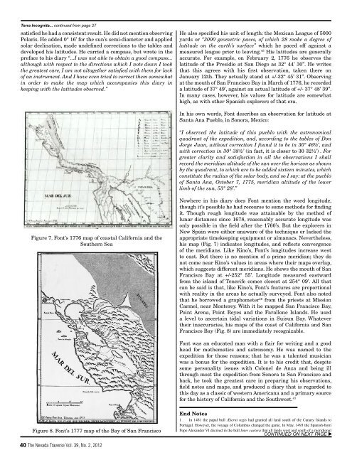
Figure 8. Font’s 1777 map <strong>of</strong> the Bay <strong>of</strong> San Francisco<br />
40 The <strong>Nevada</strong> Traverse Vol. 39, No. 2, 2012<br />
He also specified his unit <strong>of</strong> length: the Mexican League <strong>of</strong> 5000<br />
yards or “3000 geometric paces, <strong>of</strong> which 28 make a degree <strong>of</strong><br />
latitude on the earth’s surface” which he paced <strong>of</strong>f against a<br />
measured league prior to leaving. 45 His latitudes are generally<br />
accurate. For example, on February 2, 1776 he observes the<br />
latitude <strong>of</strong> the Presidio at San Diego as 32° 44’ 30”. He writes<br />
that this agrees with his first observation, taken there on<br />
January 12th. They actually stand at +/-32° 45’ 31”. Observing<br />
at the mouth <strong>of</strong> San Francisco Bay in March <strong>of</strong> 1776, he recorded<br />
a latitude <strong>of</strong> 37° 49’, against an actual latitude <strong>of</strong> +/- 37° 48’ 39”.<br />
In many cases, however, his values for latitude are somewhat<br />
high, as with other Spanish explorers <strong>of</strong> that era.<br />
In his own words, Font describes an observation for latitude at<br />
Santa Ana Pueblo, in Sonora, Mexico:<br />
“I observed the latitude <strong>of</strong> this pueblo with the astronomical<br />
quadrant <strong>of</strong> the expedition, and, according to the tables <strong>of</strong> Don<br />
Jorge Juan, without correction I found it to be in 30° 46½’, and<br />
with correction in 30° 38½’ (in fact, it is closer to 30 32½’) . For<br />
greater clarity and satisfaction in all the observations I shall<br />
record the meridian altitude <strong>of</strong> the sun over the horizon as shown<br />
by the quadrant, to which are to be added sixteen minutes, which<br />
constitute the radius <strong>of</strong> the solar body, and so I say: at the pueblo<br />
<strong>of</strong> Santa Ana, October 7, 1775, meridian altitude <strong>of</strong> the lower<br />
limb <strong>of</strong> the sun, 53° 28’.”<br />
Nowhere in his diary does Font mention the word longitude,<br />
though it’s possible he had recourse to some methods for finding<br />
it. Though rough longitude was attainable by the method <strong>of</strong><br />
lunar distances since 1678, reasonably accurate longitude was<br />
only possible in the field after the 1760’s. But the explorers in<br />
New Spain were either unaware <strong>of</strong> the technique or lacked the<br />
appropriate timekeeping equipment or almanacs. Nevertheless,<br />
his map (Fig. 7) indicates longitudes, and reflects convergence<br />
<strong>of</strong> the meridians. Like Kino’s, Font’s longitudes increase west<br />
to east. But there is no mention <strong>of</strong> a prime meridian; they do<br />
not come near Kino’s values in areas where their maps overlap,<br />
which suggests different meridians. He shows the mouth <strong>of</strong> San<br />
Francisco Bay at +/-252° 55’. Longitude measured eastward<br />
from the island <strong>of</strong> Tenerife comes closest at 254° 09’. All that<br />
can be said is that, like Kino’s, Font’s features are proportional<br />
with reality in the areas he actually surveyed. Font also noted<br />
that he borrowed a graphometer 46 from the priests at Mission<br />
Carmel, near Monterey. With it he mapped San Francisco Bay,<br />
Point Arena, Point Reyes and the Farallone Islands. He used<br />
a level to ascertain tidal variations in Suisun Bay. Whatever<br />
their inaccuracies, his maps <strong>of</strong> the coast <strong>of</strong> California and San<br />
Francisco Bay (Fig. 8) are immediately recognizable.<br />
Font was an educated man with a flair for writing and a good<br />
head for mathematics and astronomy. He was named to the<br />
expedition for those reasons; that he was a talented musician<br />
was a bonus for the expedition. It is to his credit that, despite<br />
some personality issues with Colonel de Anza and being ill<br />
through most the expedition from Sonora to San Francisco and<br />
back, he took the greatest care in preparing his observations,<br />
field notes and maps, and produced a diary that is regarded to<br />
this day as a classic <strong>of</strong> western Americana and a primary source<br />
for the history <strong>of</strong> California and the Southwest. 47<br />
End Notes<br />
1 In 1481 the papal bull Æterni regis had granted all land south <strong>of</strong> the Canary Islands to<br />
Portugal. However, the voyage <strong>of</strong> Columbus changed the game. In May, 1493 the Spanish-born<br />
Pope Alexander VI decreed in the bull Inter caetera that all lands west and south <strong>of</strong> a meridional<br />
CONTINUED ON NEXT PAGE u