Eawag Annual Report 2022
As the aquatic research institute of the ETH Domain, our research is in service of society. You can see this for yourself in our Annual Report. The annual compact review highlights the most relevant research results of the past year and shows how they were developed.
As the aquatic research institute of the ETH Domain, our research is in service of society. You can see this for yourself in our Annual Report. The annual compact review highlights the most relevant research results of the past year and shows how they were developed.

Create successful ePaper yourself
Turn your PDF publications into a flip-book with our unique Google optimized e-Paper software.
16<br />
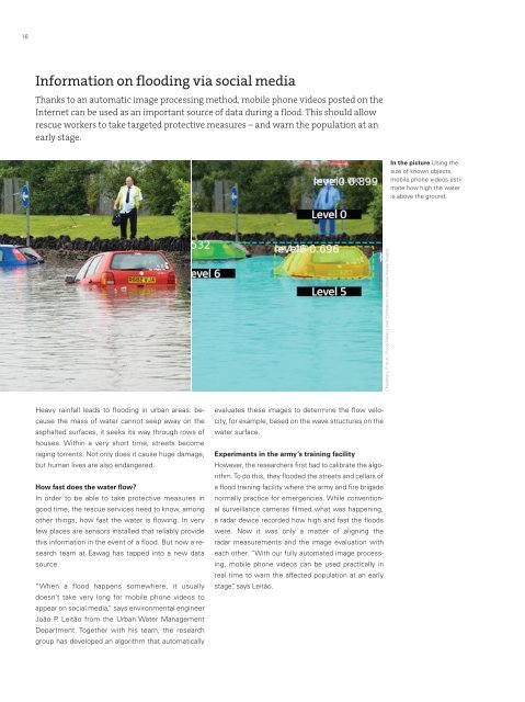
Information on flooding via social media<br />
Thanks to an automatic image processing method, mobile phone videos posted on the<br />
Internet can be used as an important source of data during a flood. This should allow<br />
rescue workers to take targeted protective measures – and warn the population at an<br />
early stage.<br />
In the picture Using the<br />
size of known objects,<br />
mobile phone videos estimate<br />
how high the water<br />
is above the ground.<br />
Chaudhary, P. et al.: Flood-Water Level Estimation from Social Media Images<br />
Heavy rainfall leads to flooding in urban areas: because<br />
the mass of water cannot seep away on the<br />
asphalted surfaces, it seeks its way through rows of<br />
houses. Within a very short time, streets become<br />
raging torrents. Not only does it cause huge damage,<br />
but human lives are also endangered.<br />
How fast does the water flow?<br />
In order to be able to take protective measures in<br />
good time, the rescue services need to know, among<br />
other things, how fast the water is flowing. In very<br />
few places are sensors installed that reliably provide<br />
this information in the event of a flood. But now a research<br />
team at <strong>Eawag</strong> has tapped into a new data<br />
source.<br />
“When a flood happens somewhere, it usually<br />
doesn’t take very long for mobile phone videos to<br />
appear on social media,” says environmental engineer<br />
João P. Leitão from the Urban Water Management<br />
Department. Together with his team, the research<br />
group has developed an algorithm that automatically<br />
evaluates these images to determine the flow velocity,<br />
for example, based on the wave structures on the<br />
water surface.<br />
Experiments in the army’s training facility<br />
However, the researchers first had to calibrate the algorithm.<br />
To do this, they flooded the streets and cellars of<br />
a flood training facility where the army and fire brigade<br />
normally practice for emergencies. While conventional<br />
surveillance cameras filmed what was happening,<br />
a radar device recorded how high and fast the floods<br />
were. Now it was only a matter of aligning the<br />
radar measurements and the image evaluation with<br />
each other. “With our fully automated image processing,<br />
mobile phone videos can be used practically in<br />
real time to warn the affected population at an early<br />
stage”, says Leitão.