ASF-2011-01

You also want an ePaper? Increase the reach of your titles
YUMPU automatically turns print PDFs into web optimized ePapers that Google loves.
www.AdkSports.com JANUARY <strong>2<strong>01</strong>1</strong> 11<br />
SNOWSHOEING & CROSS-COUNTRY SKIING<br />
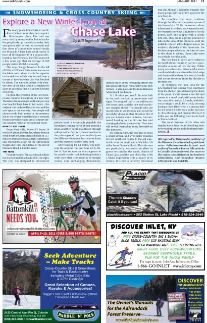
Explore a New Winter Loop at<br />
For many years, Chase Lake in northern<br />
Fulton County has been a quiet,<br />
little-known place. The trail was<br />
once used by snowmobiles, but today the<br />
few people who go there do so under their<br />
own power. With its lean-to, easy trail, and<br />
fine views of a mountain named simply<br />
the Pinnacle, Chase Lake would seem to<br />
have all the ingredients of a popular destination.<br />
Nevertheless, the DEC reported<br />
a few years ago that an average of 100<br />
people visited the lake annually.<br />
This may change, however. In the fall<br />
of 2<strong>01</strong>0, a DEC crew built a new lean-to on<br />
the lake’s north shore that is far superior<br />
to the old site, which was located near a<br />
corner of the shoreline that was blocked<br />
by alders. The new site comes with a better<br />
view of the lake, and it is reached by<br />
such an easy hike that it is sure to become<br />
a favorite.<br />
Further, the creation of the new leanto<br />
also required the cutting of a new trail.<br />
Therefore from a single trailhead you can<br />
now reach Chase Lake in two ways – the<br />
original trail to the old lean-to site, and the<br />
new spur to the new site. Few people will<br />
choose to do both routes in the summer,<br />
but in the winter when the lake is securely<br />
frozen snowshoers and cross-country skiers<br />
can now make an exceptional route.<br />
HOW TO GET THERE<br />
From Northville, follow NY Route 30<br />
north for about three miles, where Benson<br />
Road bears left. Benson Road leads in 11.7<br />
miles to Pinnacle Road, a right turn that is<br />
also marked by a sign for the Adirondack<br />
Beagle and Hare Club. Drive to the end of<br />
Pinnacle Road, 2.6 miles away.<br />
THE TRAIL<br />
From the end of Pinnacle Road, follow<br />
the marked trail that leads off to the right.<br />
The trail was designed to circumvent<br />
Chase Lake<br />
VIEW OF PINNACLE MOUNTAIN<br />
FROM CHASE LAKE.<br />
THE NEW LEAN-TO WITH FINE<br />
VIEWS OF PINNACLE AND CHASE.<br />
PHOTOS BY BILL INGERSOLL<br />
by Bill Ingersoll<br />
private land. It essentially parallels the<br />
boundary, leading north of east around a<br />
knoll, and then cutting southeast through<br />
a deep ravine. Beyond, you are so close to<br />
the private parcel that you can clearly see<br />
the difference between the cut-over forest<br />
and the mature stand on state land.<br />
After walking for 1.1 miles, you intercept<br />
the original trail and bear left to follow<br />
it. You are now on what appears to<br />
be an old woods road, following beside a<br />
wide draw that is unusual in its straight<br />
course and unchanging dimensions.<br />
Indeed much of the remaining hike to the<br />
lake passes through remarkably non-hilly<br />
terrain – a rare pause in the mountainous<br />
Adirondack landscape.<br />
At 1.8 miles you reach the new fork<br />
in the trail, marked by prominent trail<br />
signs. The original trail to the old lean-to<br />
site bears right, and the new trail continues<br />
straight ahead. The people who are<br />
mostly here to see the new lean-to will be<br />
invariably drawn in that direction. But if<br />
you can muster some patience, I recommend<br />
heading to the old site first and<br />
crossing the ice to the new site. The views<br />
will reveal themselves more favorably in<br />
this direction.<br />
So, turning right, the trail dips to cross<br />
a small stream and eventually resumes<br />
its east-northeast course to the old leanto<br />
site near the south end of the lake, 2.6<br />
miles from Pinnacle Road. This site was<br />
not particularly well-suited to allow its<br />
guests to consider the scenic charms of<br />
Chase Lake, and this was likely why it left<br />
a bland impression with so many of its<br />
visitors. It is now a perfectly functional<br />
tent site, though it is hard to imagine that<br />
many people will prefer this spot over the<br />
new lean-to.<br />
To complete the loop, continue<br />
through the alders to the open expanse of<br />
the frozen lake. While the western shore<br />
is hemmed in with extensive marshlands,<br />
the eastern shore has a number of rocky<br />
points, each one capped with a scenic<br />
tent site. They are in a prime position to<br />
take in the view of the Pinnacle, with the<br />
reddish-colored cliffs draped across the<br />
northern shoulder of the mountain. For<br />
the few people who take the time to cross<br />
to this shore in winter, Chase Lake takes<br />
on a whole new dynamic.<br />
The new lean-to site is very visible on<br />
the north shore, thanks in part to a questionable<br />
amount of tree cutting. Unlike<br />
many newer lean-tos, this one is located a<br />
comfortable distance from the lake’s edge<br />
and features fine views. It is just a 0.5-mile<br />
trek across the pond from the old site to<br />
the new site.<br />
To complete the loop, look for the<br />
new marked trail leading west-southwest<br />
from the shelter, quickly leaving the shore<br />
of the pond. It cuts across a low hill and<br />
comes to a small creek with rocky banks.<br />
You cross this creek at 0.5-mile, and without<br />
a bridge it could be a tricky crossing<br />
during a thaw. Otherwise, it is an easy hike<br />
for the next 0.5-mile back to the junction<br />
to close the loop, and then for the last 1.8<br />
miles you are following your tracks back<br />
to Pinnacle Road.<br />
The total distance of 5.9 miles will<br />
require about three hours of walking time,<br />
not counting breaks and additional explorations.<br />
Bill Ingersoll of Barneveld is publisher of<br />
the Discover the Adirondacks guidebook<br />
series (hiketheadirondacks.com) and<br />
author of Snowshoe Routes: Adirondacks<br />
& Catskills (Mountaineers). For more on<br />
this region, consult Discover the Southern<br />
Adirondacks and Snowshoe Routes:<br />
Adirondacks and Catskills.<br />
The new Shadow<br />
Catch it if you can!<br />
placidboats.com • 263 Station St, Lake Placid • 518-524-2949<br />
2123 Central Ave (Rte 5), Colonie<br />
4.25 miles west of Northway Exit 2W<br />
(518) 346-3180 • OneWithWater.com<br />
Seek Adventure<br />
– Make Tracks<br />
Cross-Country Skis & Snowshoes<br />
for Trails & Backcountry<br />
Including Metal Edge Skis<br />
& 3-Pin Bindings!<br />
Great Selection of Canoes,<br />
Kayaks & Accessories!<br />
Dagger • Bell • Swift • Wilderness Systems<br />
Perception • Mad River<br />
Discover Inlet, NY<br />
And all the beauty that surrounds us<br />
Free Cross-country Ski & Snowshoe<br />
Trails. Free Ice Skating Rink<br />
with Warming Hut. Free Sledding Hill.<br />
Great Food , Cozy Accommod ations,<br />
Groomed Snowmobile Tra ils,<br />
<br />
<br />
<br />
Fun for the W hole Family<br />
For maps & more: Inlet Area Information Office<br />
1-866-GO INLET www.inletny.com