
Create successful ePaper yourself
Turn your PDF publications into a flip-book with our unique Google optimized e-Paper software.
cept the permit. The next<br />
step was attending the manda<strong>to</strong>ry<br />
orientation meeting<br />
the following morning in<br />
Page.<br />
There were two other<br />
groups at the orientation: A<br />
30-something couple from<br />
Prescott who had been trying<br />
for a Wave permit for<br />
four years, and four women<br />
from North Carolina,<br />
who mentioned that, coming<br />
from sea level, they could<br />
already feel the effects of<br />
Page’s 4,500-foot elevation<br />
while walking around <strong>to</strong>wn.<br />
The orientation, led by a<br />
knowledgeable staff member<br />
at the Page Lake Powell<br />
Hub Visi<strong>to</strong>r Center, offered<br />
safety advice for walking<br />
in the desert (carry 1<br />
gallon of water per person,<br />
eat salty snacks, wear sunscreen),<br />
rules for hiking in<br />
the permit area (groups must<br />
stay <strong>to</strong>gether, walking sticks<br />
must be equipped with rubber<br />
tips <strong>to</strong> avoid damaging<br />
the rocks), and directions for<br />
the 3.2-mile hike from Wire<br />
Pass Trailhead <strong>to</strong> The Wave,<br />
since there is no marked<br />
trail through Coyote Buttes<br />
North. Hikers are given a<br />
cue sheet with numbered directions<br />
and pho<strong>to</strong>graphs of<br />
geological formations <strong>to</strong> use<br />
as navigations aids.<br />
Another bit of advice was<br />
<strong>to</strong> get an early start by arriving<br />
at the trailhead by<br />
dawn, which at that time of<br />
year was around 6:30 a.m.<br />
But according <strong>to</strong> the weather<br />
forecast, the temperature<br />
wouldn’t rise much<br />
above 80 degrees Fahrenheit<br />
throughout the day. Being<br />
residents of the Southwest,<br />
my wife and I often hike in<br />
hot weather, so we weren’t<br />
<strong>to</strong>o concerned about getting<br />
a super-early start. We<br />
<strong>to</strong>ok the time <strong>to</strong> make pancakes<br />
for breakfast before<br />
embarking on the hour-long<br />
drive <strong>to</strong> the trailhead – west<br />
on Highway 89 for 36 miles,<br />
then south on unpaved,<br />
dusty, bumpy House Rock<br />
Road for 8.2 miles. We arrived<br />
around 8 a.m. Utah<br />
time, and there were already<br />
five or six cars in the parking<br />
lot, including the group<br />
from North Carolina.<br />
We <strong>to</strong>ok our time getting<br />
started, making sure our water<br />
bottles and snacks were<br />
packed comfortably, applying<br />
sunscreen and signing<br />
the trail registry. As we<br />
set out along Coyote Wash,<br />
we were a few hundred feet<br />
behind the North Carolinians,<br />
but as we left the wash<br />
after about half a mile and<br />
started walking uphill, they<br />
s<strong>to</strong>pped <strong>to</strong> rest. My wife<br />
and I paused <strong>to</strong> say hello<br />
as we passed, and they said<br />
they were starting <strong>to</strong> feel<br />
the effects of the elevation<br />
– around 5,000 feet at that<br />
point. They would be fine,<br />
though, just a little slower<br />
than they had anticipated.<br />
We would cross paths again<br />
at The Wave later in the day.<br />
The rainy spring in the<br />
West had resulted in an<br />
abundant desert wildflower<br />
season, and although Coyote<br />
Buttes North is not particularly<br />
famous for its blooms,<br />
we did spot small clusters<br />
of reddish-orange Indian<br />
paintbrush, purple larkspur,<br />
and white and yellow<br />
primrose. At the same time,<br />
there hadn’t been much rain<br />
or wind during the previous<br />
two weeks, so the abundance<br />
of footprints made it<br />
easy <strong>to</strong> follow the unmarked<br />
“trail” as we crossed the sandy<br />
plain <strong>to</strong>ward our next<br />
navigation point, a small<br />
saddle on a sands<strong>to</strong>ne ridge<br />
on the horizon.<br />
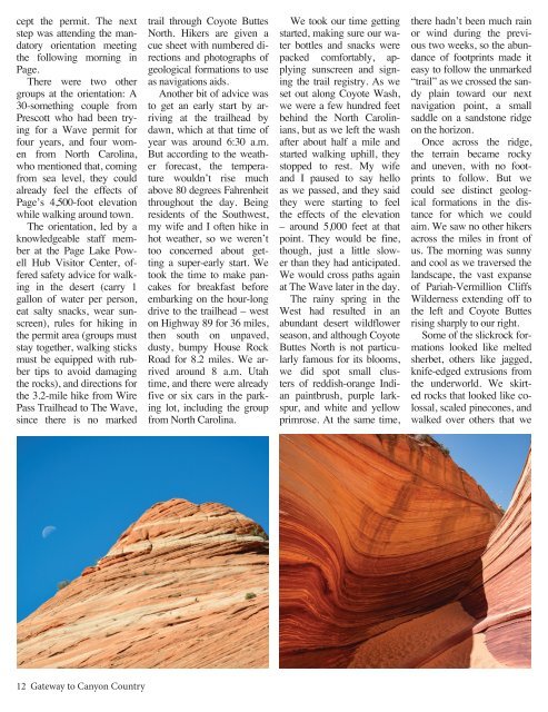
Once across the ridge,<br />
the terrain became rocky<br />
and uneven, with no footprints<br />
<strong>to</strong> follow. But we<br />
could see distinct geological<br />
formations in the distance<br />
for which we could<br />
aim. We saw no other hikers<br />
across the miles in front of<br />
us. The morning was sunny<br />
and cool as we traversed the<br />
landscape, the vast expanse<br />
of Pariah-Vermillion Cliffs<br />
Wilderness extending off <strong>to</strong><br />
the left and Coyote Buttes<br />
rising sharply <strong>to</strong> our right.<br />
Some of the slickrock formations<br />
looked like melted<br />
sherbet, others like jagged,<br />
knife-edged extrusions from<br />
the underworld. We skirted<br />
rocks that looked like colossal,<br />
scaled pinecones, and<br />
walked over others that we<br />
12 <strong>Gateway</strong> <strong>to</strong> <strong>Canyon</strong> <strong>Country</strong>