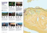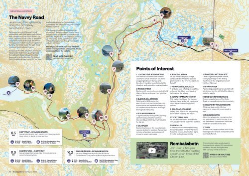
Map of Rombaksbotn

You also want an ePaper? Increase the reach of your titles
YUMPU automatically turns print PDFs into web optimized ePapers that Google loves.
INDUSTRIAL HERITAGE<br />
The Navvy Road<br />
Journeying through history<br />
along the old railway<br />
construction road.<br />
Renowned as one <strong>of</strong> Norway's most<br />
picturesque trails, the navvy road <strong>of</strong>fers a<br />
well-marked path that traces a historical<br />
route. Originally constructed to transport<br />
crews and materials through the remote<br />
Norwegian-Swedish mountain regions for<br />
building the Ofoten Line, this path holds<br />
immense historical significance.<br />
It begins at the l<strong>of</strong>ty mountain plateau <strong>of</strong><br />
Riksgränsen (520 masl), guiding hikers<br />
through lush, steep valleys, ultimately<br />
descending to the stunning Rombaken<br />
fjord. Covering a distance <strong>of</strong> 16.2 km from<br />
the Swedish border to <strong>Rombaksbotn</strong>,<br />
completing this hike means you've crossed<br />
Norway on foot!<br />
The beauty <strong>of</strong> the Navvy Road lies in its<br />
versatility, it accommodates various hiking<br />
lengths and is suitable for most individuals,<br />
provided they have sturdy footwear. So, lace<br />
up your hiking boots and prepare for an<br />
unforgettable journey through history and<br />
nature's wonders.<br />
Ensure you pre-book your boat transport<br />
online before your hike. All essential details<br />
are accessible on the website.<br />
READ MORE ONLINE<br />
visitnarvik.com/navvy-road<br />
6<br />
5<br />
4<br />
BJØRNFJELL<br />
3<br />
NORWAY<br />
SWEDEN<br />
2<br />
1<br />
E10<br />
RIKSGRÄNSEN<br />
7<br />
Points <strong>of</strong> Interest<br />
6.5<br />
km<br />
17<br />
16<br />
OFOTEN LINE<br />
15<br />
14<br />
KATTERAT - ROMBAKSBOTN<br />
Narvik to Katterat by train, hike 6.5 km to <strong>Rombaksbotn</strong><br />
Quay, return to Narvik by boat and bus.<br />
13<br />
12<br />
KATTERAT<br />
11<br />
8<br />
1 LOCOMOTIVE ROUNDHOUSE<br />
This historic roundhouse at Niehku<br />
used to be a hub for steam-era trains<br />
swapping between Norway and<br />
Sweden. It handled essential tasks like<br />
cleaning, and restocking coal and water.<br />
2 RIKSGRÄNSEN<br />
Bunkers with connections to both World<br />
Wars, <strong>of</strong>fering a glimpse into historical<br />
events.<br />
3 BJØRNFJELL STATION<br />
Built back in 1923 during the<br />
electrification <strong>of</strong> the Ofoten Line, this<br />
station sits at an impressive height <strong>of</strong><br />
517 meters above sea level, making it<br />
the highest in the area.<br />
4 SOLHEIMSBRAKKA<br />
A significant site during WW2, serving<br />
as the headquarters for German<br />
General Eduard Dietl during the battle<br />
for Narvik.<br />
5 OLADALEN<br />
Explore bunkers on the mountainside<br />
used as shelter for soldiers. Remember<br />
to bring a flashlight and waterpro<strong>of</strong><br />
shoes for a safe visit inside.<br />
6 NORDDALSBRUA<br />
An old Pendulum-pillar bridge<br />
constructed in 1902 and featured<br />
prominently in the film "The Battle for<br />
Narvik."<br />
7 VIEWPOINT NORDDALEN<br />
A fantastic spot <strong>of</strong>fering views <strong>of</strong> the<br />
untamed Norddalen and passing<br />
trains along the railway.<br />
8 AERIAL TRAMWAY STATION<br />
This station facilitated the transfer<br />
between large and small cable cars,<br />
providing an interesting sight for<br />
visitors.<br />
9 RAILROAD CROSSING<br />
Safety first! Watch out for passing<br />
trains when crossing the tracks.<br />
10 VOKTERBOLIGEN<br />
An old worker's house available for<br />
rent, equipped with outhouse facilities.<br />
11 HUNDALEN<br />
A former administration site during<br />
the construction <strong>of</strong> the Ofoten Line,<br />
featuring houses, information signs,<br />
fire pits, and outhouse toilets.<br />
12 POWER PLANT RUIN SITE<br />
Once a significant power station,<br />
supplying energy to the drilling<br />
machines in the longest tunnels <strong>of</strong><br />
Northern Norway.<br />
13 STORFOSSEN<br />
A picturesque spot near a waterfall with<br />
benches and a fire pit. Mind the slippery<br />
rocks for safety.<br />
14 BRIDGE SØSTERBEKKENE<br />
Enjoy a beautiful view <strong>of</strong> the Sister<br />
Streams cascading down the mountain.<br />
15 VIEWPOINT ROMBAKSBOTN<br />
A high vantage point <strong>of</strong>fering<br />
panoramic views <strong>of</strong> the surrounding<br />
area.<br />
16 ROMBAKSBOTN<br />
A junction where you can explore the<br />
old main street or visit the ruins <strong>of</strong> an<br />
old farmstead. Shelters and outhouse<br />
toilets are available in the area.<br />
17 QUAY<br />
Access boat transportation back to the<br />
floating dock in Sildvik and continue the<br />
journey to Narvik.<br />
11.0<br />
km<br />
D: 10:30 - Narvik Station<br />
A: 11:05 - Katterat Station<br />
D: 17:00 <strong>Rombaksbotn</strong> Quay<br />
A: 18:00 Narvik Station<br />
BJØRNFJELL - KATTERAT<br />
Narvik to Bjørnfjell by train, hike 11.0 km to Katterat,<br />
return to Narvik by train.<br />
16.2<br />
km<br />
RIKSGRÄNSEN - ROMBAKSBOTN<br />
Narvik to Riksgränsen by train, hike 16.2 km to<br />
<strong>Rombaksbotn</strong> Quay, return to Narvik by boat and bus.<br />
10 9 WATCH ON YOUTUBE<br />
<strong>Rombaksbotn</strong><br />
Join us on a 120-year<br />
time travel to the bustling<br />
construction town <strong>of</strong> the<br />
Ofoten Line.<br />
The animated video vividly depicts<br />
<strong>Rombaksbotn</strong>, where 700 industrious<br />
residents thrived during the late<br />
19th-century construction era.<br />
@museum<strong>of</strong>oten4008<br />
D: 10:30 - Narvik Station<br />
A: 11:20 - Bjørnfjell Station<br />
D: 18:01 Katterat Station<br />
A: 18:38 Narvik Station<br />
D: 10:30 - Narvik Station<br />
A: 11:25 - Riksgränsen Station<br />
D: 17:00 <strong>Rombaksbotn</strong> Quay<br />
A: 18:00 Narvik Station<br />
64 Travelguide Narvik Region 2024 65