

The Sirte Basin Province of Libya—Sirte-Zelten Total ... - the USGS
The Sirte Basin Province of Libya—Sirte-Zelten Total ... - the USGS
The Sirte Basin Province of Libya—Sirte-Zelten Total ... - the USGS

Create successful ePaper yourself
Turn your PDF publications into a flip-book with our unique Google optimized e-Paper software.
30°<br />
25°<br />
20°<br />
N I G E R<br />
15°E 20°E 25°E 30°E<br />
Gulf <strong>of</strong><br />
<strong>Sirte</strong><br />
Waddan (Jebel Uddan) Platform<br />
Hun Graben<br />
Zallah (Tagrifet) Trough<br />
WESTERN<br />
SHELF Aswad<br />
Platform<br />
Az Zahrah (Al Hufrah, Dahra) Platform<br />
Al Bayda<br />
Platform<br />
Mediterranean Sea<br />
Benghazi<br />
Maradah Trough<br />
Zaltan (Al Janamah) Platform<br />
(Ajdabiya, Kalash) Trough<br />
Suluq<br />
Low<br />
Al Jabal<br />
Al Akhdar<br />
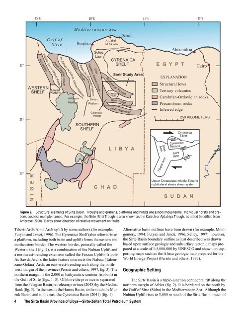
Tibesti Arch/Alma Arch uplift by some authors (for example,<br />
Futyan and Jawzi, 1996). <strong>The</strong> Cyrenaica Shelf (also referred to as<br />
a platform, including both basin and uplift) forms <strong>the</strong> eastern and<br />
nor<strong>the</strong>astern border. <strong>The</strong> western border, generally called <strong>the</strong><br />
Western Shelf (fig. 2), is a combination <strong>of</strong> <strong>the</strong> Nubian Uplift and<br />
a northwest-trending extension called <strong>the</strong> Fezzan Uplift (Tripoli-<br />
As Sawda Arch); <strong>the</strong> latter feature intersects <strong>the</strong> Nafusa (Talemzane-Gefara)<br />
Arch, an east-west-trending arch along <strong>the</strong> northwest<br />
margin <strong>of</strong> <strong>the</strong> province (Persits and o<strong>the</strong>rs, 1997; fig. 3). <strong>The</strong><br />
nor<strong>the</strong>rn margin is <strong>the</strong> 2,000 m bathymetric contour (isobath) in<br />
<strong>the</strong> Gulf <strong>of</strong> <strong>Sirte</strong> (figs. 1–3). Offshore <strong>the</strong> province is separated<br />
from <strong>the</strong> Pelagian <strong>Basin</strong> petroleum province (2048) by <strong>the</strong> Medina<br />
Bank (fig. 3). To <strong>the</strong> west is <strong>the</strong> Hamra <strong>Basin</strong>, to <strong>the</strong> south <strong>the</strong> Murzuk<br />
<strong>Basin</strong>, and to <strong>the</strong> east <strong>the</strong> Cyrenaica <strong>Basin</strong> (2041) (fig. 1).<br />
Darnah<br />
CYRENAICA<br />
SHELF<br />
Sarir Study Area<br />
L I B Y A<br />
4 <strong>The</strong> <strong>Sirte</strong> <strong>Basin</strong> <strong>Province</strong> <strong>of</strong> Libya—<strong>Sirte</strong>-<strong>Zelten</strong> <strong>Total</strong> Petroleum System<br />
<strong>Sirte</strong><br />
Zeltan<br />
Platform<br />
Calanscio<br />
Trough<br />
SOUTHERN<br />
SHELF<br />
Hameimat Trough<br />
Messlah<br />
High<br />
C H A D<br />
Sarir Trough<br />
South Depression<br />
<strong>Sirte</strong><br />
Arm<br />
Arm<br />
Alternative basin outlines have been drawn (for example, Montgomery,<br />
1994; Futyan and Jawzi, 1996, Selley, 1997); however,<br />
<strong>the</strong> <strong>Sirte</strong> <strong>Basin</strong> boundary outline as just described was drawn<br />
based upon surface geologic and subsurface tectonic maps prepared<br />
at a scale <strong>of</strong> 1:5,000,000 by UNESCO and shown on supporting<br />
maps such as <strong>the</strong> Africa geologic map prepared for <strong>the</strong><br />
World Energy Project (Persits and o<strong>the</strong>rs, 1997).<br />
Geographic Setting<br />
mTibesti<br />
Tibesti Arm<br />
Alexandria<br />
E G Y P T<br />
EXPLANATION<br />
Precambrian rocks<br />
Inferred edge<br />
Cyrenaica<br />
Terrane<br />
Sarir<br />
Arm<br />
Cyrenaica<br />
Silver<br />
Upper Cretaceous-middle Eocene<br />
right-lateral stress shear system<br />
Cairo<br />
Structural lows<br />
Tertiary volcanics<br />
Cambrian-Ordovician rocks<br />
0 250 KILOMETERS<br />
S U D A N<br />
Figure 2. Structural elements <strong>of</strong> <strong>Sirte</strong> <strong>Basin</strong>. Troughs and grabens, platforms and horsts are synonymous terms. Individual horsts and grabens<br />
possess multiple names. For example, <strong>the</strong> <strong>Sirte</strong> (Sirt) Trough is also known as <strong>the</strong> Kalash or Ajdabiya Trough, as noted (modified from<br />
Ambrose, 2000). Barbs show direction <strong>of</strong> relative movement on faults.<br />
<strong>The</strong> <strong>Sirte</strong> <strong>Basin</strong> is a triple-junction continental rift along <strong>the</strong><br />
nor<strong>the</strong>rn margin <strong>of</strong> Africa (fig. 2). It is bordered on <strong>the</strong> north by<br />
<strong>the</strong> Gulf <strong>of</strong> <strong>Sirte</strong> (Sidra) in <strong>the</strong> Mediterranean Sea. Although <strong>the</strong><br />
Nubian Uplift rises to 3,000 m south <strong>of</strong> <strong>the</strong> <strong>Sirte</strong> <strong>Basin</strong>, much <strong>of</strong>


