

The Sirte Basin Province of Libya—Sirte-Zelten Total ... - the USGS
The Sirte Basin Province of Libya—Sirte-Zelten Total ... - the USGS
The Sirte Basin Province of Libya—Sirte-Zelten Total ... - the USGS

You also want an ePaper? Increase the reach of your titles
YUMPU automatically turns print PDFs into web optimized ePapers that Google loves.
<strong>The</strong> <strong>Sirte</strong> <strong>Basin</strong> <strong>Province</strong> <strong>of</strong> Libya—<strong>Sirte</strong>-<strong>Zelten</strong><br />
<strong>Total</strong> Petroleum System<br />
By Thomas S. Ahlbrandt<br />
U.S. Geological Survey Bulletin 2202–F<br />
U.S. Department <strong>of</strong> <strong>the</strong> Interior<br />
U.S. Geological Survey
U.S. Department <strong>of</strong> <strong>the</strong> Interior<br />
Gale A. Norton, Secretary<br />
U.S. Geological Survey<br />
Charles G. Groat, Director<br />
Version 1.0, 2001<br />
This publication is only available online at:<br />
http://geology.cr.usgs.gov/pub/bulletins/b2202-f/<br />
Any use <strong>of</strong> trade, product, or firm names in this publication<br />
is for descriptive purposes only and does not<br />
imply endorsement by <strong>the</strong> U.S. Government<br />
Manuscript approved for publication May 8, 2001<br />
Published in <strong>the</strong> Central Region, Denver, Colorado<br />
Graphics by Susan M. Walden, Margarita V. Zyrianova<br />
Photocomposition by William Sowers<br />
Edited by L.M. Carter
Contents<br />
Foreword ............................................................................................................................................... 1<br />
Abstract................................................................................................................................................. 1<br />
Introduction .......................................................................................................................................... 2<br />
Acknowledgments............................................................................................................................... 2<br />
<strong>Province</strong> Geology................................................................................................................................. 2<br />
<strong>Province</strong> Boundary..................................................................................................................... 2<br />
Geographic Setting..................................................................................................................... 4<br />
Political and Exploration History ............................................................................................. 5<br />
Geologic Setting.......................................................................................................................... 7<br />
<strong>Total</strong> Petroleum System ..................................................................................................................... 11<br />
Petroleum Occurrence .............................................................................................................. 11<br />
Source Rock ................................................................................................................................ 13<br />
Overburden Rock ........................................................................................................................ 17<br />
Reservoir Rock ............................................................................................................................ 17<br />
Seal Rock ..................................................................................................................................... 21<br />
Trap Style ..................................................................................................................................... 21<br />
Petroleum Assessment ...................................................................................................................... 21<br />
References Cited ................................................................................................................................. 27<br />
Figures<br />
1–3. Maps showing:<br />
1. <strong>Sirte</strong>-<strong>Zelten</strong> <strong>Total</strong> Petroleum System, assessment units,<br />
and oil and gas field centerpoints ......................................................................... 3<br />
2. Structural elements <strong>of</strong> <strong>Sirte</strong> <strong>Basin</strong> ........................................................................ 4<br />
3. Central Mediterranean Sea, <strong>USGS</strong>-defined Pelagian province,<br />
and <strong>of</strong>fshore areas <strong>of</strong> <strong>Sirte</strong> <strong>Basin</strong>......................................................................... 5<br />
4. Nor<strong>the</strong>ast-southwest <strong>of</strong>fshore regional cross section ........................................ 6<br />
5. East-west onshore structural cross section.................................................................. 8<br />
6. Pre-Hercynian subcrop map in <strong>Sirte</strong> <strong>Basin</strong> area .......................................................... 8<br />
7. Stratigraphic section in central <strong>Sirte</strong> <strong>Basin</strong>................................................................... 9<br />
8. Stratigraphic section in eastern <strong>Sirte</strong> <strong>Basin</strong>.................................................................. 10<br />
9. Schematic cross section showing general structural position,<br />
stratigraphic age, and lithology <strong>of</strong> most traps within<br />
onshore <strong>Sirte</strong> <strong>Basin</strong>............................................................................................................ 11<br />
10. Diagram showing burial history curve for deepest portion<br />
<strong>of</strong> <strong>Sirte</strong> Trough..................................................................................................................... 12<br />
11. Map showing postulated petroleum migration pathways for oil<br />
sourced from Upper Cretaceous shales......................................................................... 13<br />
III
12. Map showing postulated pre-Upper Cretaceous source areas and migration<br />
pathways <strong>of</strong> nonmarine source rocks in eastern <strong>Sirte</strong> <strong>Basin</strong>..................................... 14<br />
13. Oil geochemistry plots for 81 oil samples from 55 fields in <strong>Sirte</strong> <strong>Basin</strong> ..................... 15<br />
14. Events chart for <strong>Sirte</strong>-<strong>Zelten</strong> <strong>Total</strong> Petroleum System ................................................. 16<br />
15. Map showing tectonic elements and oil fields in eastern <strong>Sirte</strong> <strong>Basin</strong> ...................... 18<br />
16. Stratigraphic cross section in Calanscio-Hameimat Trough ...................................... 19<br />
17. East-west structural cross section across western margin <strong>of</strong> Messla High ........... 20<br />
18. Schematic structural cross section from Sarir Trough across<br />
Messla High and into Hameimat Trough........................................................................ 20<br />
19. Stratigraphic cross section through <strong>Zelten</strong> Formation bioherms............................... 22<br />
20. Cumulative plot <strong>of</strong> volume <strong>of</strong> known oil versus field discovery year<br />
for Sou<strong>the</strong>ast <strong>Sirte</strong> Clastics Assessment Unit ............................................................... 23<br />
21–23. Histograms showing:<br />
21. Volumetric assessment results for geologically risked assessment<br />
units in <strong>Sirte</strong>-<strong>Zelten</strong> <strong>Total</strong> Petroleum System in <strong>Sirte</strong> <strong>Basin</strong> ............................. 25<br />
22. Volumetric assessment results for geologically risked and unrisked<br />
assessment units in <strong>Sirte</strong>-<strong>Zelten</strong> <strong>Total</strong> Petroleum System in <strong>Sirte</strong> <strong>Basin</strong>....... 25<br />
23. Comparison <strong>of</strong> U.S. Geological Survey World Energy Assessment Team<br />
(2000) mean risked estimates for oil, natural gas, and natural gas liquids<br />
versus Masters and o<strong>the</strong>rs’ (1994) mean estimates .......................................... 26<br />
Tables<br />
IV<br />
1. <strong>Sirte</strong>-<strong>Zelten</strong>, <strong>Total</strong> Petroleum System 204301—assessment<br />
results summary.................................................................................................................. 24
<strong>The</strong> <strong>Sirte</strong> <strong>Basin</strong> <strong>Province</strong> <strong>of</strong> Libya—<strong>Sirte</strong>-<strong>Zelten</strong><br />
<strong>Total</strong> Petroleum System<br />
By Thomas S. Ahlbrandt<br />
Foreword<br />
This report was prepared as part <strong>of</strong> <strong>the</strong> World Energy Project<br />
<strong>of</strong> <strong>the</strong> U.S. Geological Survey. For this project, <strong>the</strong> world was<br />
divided into eight regions and 937 geologic provinces. Of <strong>the</strong>se,<br />
parts <strong>of</strong> 128 geologic provinces were assessed for undiscovered<br />
petroleum resources. <strong>The</strong> primary documentation for <strong>the</strong>se<br />
assessments is in U.S. Geological Survey World Energy Assessment<br />
Team (2000). <strong>The</strong> petroleum geology <strong>of</strong> <strong>the</strong>se priority and<br />
boutique provinces is described in this series <strong>of</strong> reports. Seventysix<br />
“priority” provinces (exclusive <strong>of</strong> <strong>the</strong> United States and chosen<br />
for <strong>the</strong>ir high ranking) and 52 “boutique” provinces (exclusive<br />
<strong>of</strong> <strong>the</strong> United States) were selected for appraisal <strong>of</strong> oil and<br />
gas resources. Boutique provinces were chosen for <strong>the</strong>ir anticipated<br />
petroleum richness or special regional economic or strategic<br />
importance.<br />
<strong>The</strong> purpose <strong>of</strong> <strong>the</strong> World Energy Project is to assess <strong>the</strong><br />
quantities <strong>of</strong> oil, gas, and natural gas liquids that have <strong>the</strong> potential<br />
to be added to reserves within <strong>the</strong> next 30 years. <strong>The</strong>se volumes<br />
ei<strong>the</strong>r reside in undiscovered fields whose sizes exceed <strong>the</strong><br />
stated minimum-field-size cut<strong>of</strong>f value for <strong>the</strong> assessment unit<br />
(variable, but must be at least 1 million barrels <strong>of</strong> oil equivalent)<br />
or occur as reserve growth <strong>of</strong> fields already discovered.<br />
<strong>The</strong> total petroleum system constitutes <strong>the</strong> basic geologic<br />
unit <strong>of</strong> <strong>the</strong> oil and gas assessment. <strong>The</strong> total petroleum system<br />
includes all genetically related petroleum that occurs in shows<br />
and accumulations (discovered and undiscovered) that (1) has<br />
been generated by a pod or by closely related pods <strong>of</strong> mature<br />
source rock, and (2) exists within a limited mappable geologic<br />
space, along with <strong>the</strong> o<strong>the</strong>r essential mappable geologic elements<br />
(reservoir, seal, and overburden rocks) that control <strong>the</strong> fundamental<br />
processes <strong>of</strong> generation, expulsion, migration, entrapment,<br />
and preservation <strong>of</strong> petroleum. <strong>The</strong> minimum petroleum<br />
system is that part <strong>of</strong> a total petroleum system encompassing<br />
discovered shows and accumulations along with <strong>the</strong> geologic<br />
space in which <strong>the</strong> various essential elements have been proved<br />
by <strong>the</strong>se discoveries.<br />
An assessment unit is a mappable part <strong>of</strong> a total petroleum<br />
system in which discovered and undiscovered fields constitute a<br />
single, relatively homogeneous population such that <strong>the</strong> chosen<br />
methodology <strong>of</strong> resource assessment based on estimation <strong>of</strong> <strong>the</strong><br />
number and sizes <strong>of</strong> undiscovered fields is applicable. A total<br />
petroleum system may equate to a single assessment unit, or it<br />
may be subdivided into two or more assessment units if each unit<br />
is sufficiently homogeneous in terms <strong>of</strong> geology, exploration considerations,<br />
and risk to assess individually.<br />
A graphical depiction <strong>of</strong> <strong>the</strong> elements <strong>of</strong> a total petroleum<br />
system is provided in <strong>the</strong> form <strong>of</strong> an events chart that shows <strong>the</strong><br />
times <strong>of</strong> (1) deposition <strong>of</strong> essential rock units; (2) trap formation;<br />
(3) generation, migration, and accumulation <strong>of</strong> hydrocarbons;<br />
and (4) preservation <strong>of</strong> hydrocarbons.<br />
A numeric code identifies each region, province, total petroleum<br />
system, and assessment unit; <strong>the</strong>se codes are uniform<br />
throughout <strong>the</strong> project and will identify <strong>the</strong> same type <strong>of</strong> entity in<br />
any <strong>of</strong> <strong>the</strong> publications. <strong>The</strong> code is as follows:<br />
Example<br />
Region, single digit<br />
3<br />
<strong>Province</strong>, three digits to <strong>the</strong> right <strong>of</strong> region code 3162<br />
<strong>Total</strong> petroleum system, two digits to <strong>the</strong> right<br />
<strong>of</strong> province code 316205<br />
Assessment unit, two digits to <strong>the</strong> right <strong>of</strong> petroleum<br />
system code 31620504<br />
<strong>The</strong> codes for <strong>the</strong> regions and provinces are listed in U.S.<br />
Geological Survey World Energy Assessment Team (2000).<br />
Oil and gas reserves quoted in this report are derived from<br />
Petroconsultants’ Petroleum Exploration and Production database<br />
(Petroconsultants, 1996) and o<strong>the</strong>r area reports from Petroconsultants,<br />
Inc., unless o<strong>the</strong>rwise noted.<br />
Figure(s) in this report that show boundaries <strong>of</strong> <strong>the</strong> total<br />
petroleum system(s), assessment units, and pods <strong>of</strong> active source<br />
rocks were compiled using geographic information system (GIS)<br />
s<strong>of</strong>tware. Political boundaries and cartographic representations<br />
were taken, with permission, from Environmental Systems<br />
Research Institute’s ArcWorld 1:3 million digital coverage<br />
(1992), have no political significance, and are displayed for general<br />
reference only. Oil and gas field centerpoints shown in <strong>the</strong>se<br />
illustrations are reproduced, with permission, from Petroconsultants<br />
(1996).<br />
Abstract<br />
<strong>The</strong> <strong>Sirte</strong> (Sirt) <strong>Basin</strong> province ranks 13th among <strong>the</strong><br />
world’s petroleum provinces, having known reserves <strong>of</strong> 43.1 billion<br />
barrels <strong>of</strong> oil equivalent (36.7 billion barrels <strong>of</strong> oil, 37.7 trillion<br />
cubic feet <strong>of</strong> gas, 0.1 billion barrels <strong>of</strong> natural gas liquids). It<br />
includes an area about <strong>the</strong> size <strong>of</strong> <strong>the</strong> Williston <strong>Basin</strong> <strong>of</strong> <strong>the</strong> nor<strong>the</strong>rn<br />
United States and sou<strong>the</strong>rn Canada ( ≈490,000<br />
square kilometers).<br />
<strong>The</strong> province contains one dominant total petroleum<br />
system, <strong>the</strong> <strong>Sirte</strong>-<strong>Zelten</strong>, based on geochemical data. <strong>The</strong> Upper<br />
Cretaceous <strong>Sirte</strong> Shale is <strong>the</strong> primary hydrocarbon source bed.<br />
Reservoirs range in rock type and age from fractured Precambrian<br />
basement, clastic reservoirs in <strong>the</strong> Cambrian-Ordovician<br />
Gargaf sandstones, and Lower Cretaceous Nubian (Sarir) Sandstone<br />
to Paleocene <strong>Zelten</strong> Formation and Eocene carbonates<br />
commonly in <strong>the</strong> form <strong>of</strong> bioherms. More than 23 large oil fields<br />
(>100 million barrels <strong>of</strong> oil equivalent) and 16 giant oil fields<br />
(>500 million barrels <strong>of</strong> oil equivalent) occur in <strong>the</strong> province.<br />
Abstract 1
Production from both clastic and carbonate onshore reservoirs is<br />
associated with well-defined horst blocks related to a triple junction<br />
with three arms—an eastern Sarir arm, a nor<strong>the</strong>rn <strong>Sirte</strong> arm,<br />
and a southwestern Tibesti arm. Stratigraphic traps in combination<br />
with <strong>the</strong>se horsts in <strong>the</strong> Sarir arm are shown as giant fields<br />
(for example, Messla and Sarir fields in <strong>the</strong> sou<strong>the</strong>astern portion<br />
<strong>of</strong> <strong>the</strong> province). Significant potential is identified in areas marginal<br />
to <strong>the</strong> horsts, in <strong>the</strong> deeper grabens and in <strong>the</strong> <strong>of</strong>fshore area.<br />
Four assessment units are defined in <strong>the</strong> <strong>Sirte</strong> <strong>Basin</strong> province,<br />
two reflecting established clastic and carbonate reservoir<br />
areas and two defined as hypo<strong>the</strong>tical units. Of <strong>the</strong> latter, one is<br />
<strong>of</strong>fshore in water depths greater than 200 meters, and <strong>the</strong> o<strong>the</strong>r is<br />
onshore where clastic units, mainly <strong>of</strong> Mesozoic age, may be reservoirs<br />
for laterally migrating hydrocarbons that were generated<br />
in <strong>the</strong> deep-graben areas.<br />
<strong>The</strong> <strong>Sirte</strong> <strong>Basin</strong> reflects significant rifting in <strong>the</strong> Early Cretaceous<br />
and syn-rift sedimentary filling during Cretaceous<br />
through Eocene time, and post-rift deposition in <strong>the</strong> Oligocene<br />
and Miocene. Multiple reservoirs are charged largely by vertically<br />
migrating hydrocarbons along horst block faults from<br />
Upper Cretaceous source rocks that occupy structurally low positions<br />
in <strong>the</strong> grabens. Evaporites in <strong>the</strong> middle Eocene, mostly<br />
post-rift, provide an excellent seal for <strong>the</strong> <strong>Sirte</strong>-<strong>Zelten</strong> hydrocarbon<br />
system. <strong>The</strong> <strong>of</strong>fshore part <strong>of</strong> <strong>the</strong> <strong>Sirte</strong> <strong>Basin</strong> is complex, with<br />
subduction occurring to <strong>the</strong> nor<strong>the</strong>ast <strong>of</strong> <strong>the</strong> province boundary,<br />
which is drawn at <strong>the</strong> 2,000-meter isobath. Possible petroleum<br />
systems may be present in <strong>the</strong> deep <strong>of</strong>fshore grabens on <strong>the</strong> <strong>Sirte</strong><br />
Rise such as those involving Silurian and Eocene rocks; however,<br />
potential <strong>of</strong> <strong>the</strong>se systems remains speculative and was not<br />
assessed.<br />
Introduction<br />
<strong>The</strong> <strong>Sirte</strong> <strong>Basin</strong> province ranks 13th among <strong>the</strong> world’s<br />
petroleum provinces, exclusive <strong>of</strong> <strong>the</strong> U.S. provinces, with 43.1<br />
billion barrels <strong>of</strong> oil equivalent (BBOE) <strong>of</strong> known petroleum volume,<br />
and it ranks 15th if U.S. petroleum provinces are included<br />
(Klett and o<strong>the</strong>rs, 1997). <strong>The</strong> <strong>Sirte</strong> <strong>Basin</strong> province is considered a<br />
“priority” province by <strong>the</strong> World Energy Assessment Team as<br />
described in <strong>the</strong> Foreword. Sixteen giant (>500 million barrels <strong>of</strong><br />
oil equivalent (MMBOE)) fields occur in <strong>the</strong> province; reservoirs<br />
range in age from Precambrian to Miocene. Exploration has<br />
focused on structural highs, principally <strong>the</strong> horst blocks such as<br />
<strong>the</strong> Waddan, Az Zahrah, and Zaltan platforms (also variously<br />
known as Jebel Uddan, Beda, Dahra, Al Hufra, and Zeltan platforms)<br />
(figs. 1, 2). <strong>The</strong>se platforms are dominated by carbonate<br />
and bioherm Tertiary reservoirs <strong>of</strong> Tertiary age. In <strong>the</strong> eastern<br />
<strong>Sirte</strong> <strong>Basin</strong>, significant stratigraphic clastic traps superimposed<br />
on structural highs principally occur in Mesozoic clastic reservoirs<br />
such as at Sarir and Messla fields (fig. 1).<br />
<strong>The</strong> <strong>Sirte</strong> <strong>Basin</strong> province is characterized by one dominant<br />
petroleum system, <strong>the</strong> <strong>Sirte</strong>-<strong>Zelten</strong>, which is subdivided into four<br />
assessment units (fig. 1). <strong>The</strong> <strong>Sirte</strong> <strong>Basin</strong> (also referred to as “Sirt<br />
<strong>Basin</strong>”) is a late Mesozoic and Tertiary continental rift, triple<br />
junction, in nor<strong>the</strong>rn Africa that borders a relatively stable Paleozoic<br />
craton and cratonic sag basins along its sou<strong>the</strong>rn margins<br />
(fig. 2). <strong>The</strong> province extends <strong>of</strong>fshore into <strong>the</strong> Mediterranean<br />
Sea, with <strong>the</strong> nor<strong>the</strong>rn boundary drawn at <strong>the</strong> 2,000 meter (m)<br />
2 <strong>The</strong> <strong>Sirte</strong> <strong>Basin</strong> <strong>Province</strong> <strong>of</strong> Libya—<strong>Sirte</strong>-<strong>Zelten</strong> <strong>Total</strong> Petroleum System<br />
bathymetric contour. <strong>The</strong> thickness <strong>of</strong> sediments in <strong>the</strong> province<br />
increases from about 1 kilometer (km) near <strong>the</strong> Nubian (also<br />
known as Tibesti) Uplift on <strong>the</strong> south to as much as 7 km <strong>of</strong>fshore<br />
in <strong>the</strong> nor<strong>the</strong>rn Gulf <strong>of</strong> <strong>Sirte</strong>. <strong>The</strong> onshore area is relatively well<br />
explored for structures, which are dominated by regionally extensive<br />
horsts and grabens (fig. 2). Hydrocarbon resources are<br />
approximately equally divided between carbonate and clastic reservoirs<br />
(pre-Tertiary, dominantly clastic; Tertiary, dominantly<br />
carbonate reservoirs). <strong>The</strong> prospective area in <strong>the</strong> province covers<br />
about 230,000 km2<br />
(Montgomery, 1994; Hallett and El Ghoul,<br />
1996; MacGregor and Moody, 1998). <strong>The</strong> <strong>of</strong>fshore portion (figs.<br />
3, 4) is far less explored and its petroleum potential is largely<br />
unknown.<br />
Offshore, geologic relations in <strong>the</strong> <strong>Sirte</strong> <strong>Basin</strong> province indicate<br />
a potential for major reserves to be added by <strong>the</strong> dominant<br />
Mesozoic system, but Paleozoic and Cenozoic petroleum systems<br />
may be proven to exist as well. Speculative hydrocarbon systems<br />
are also postulated for <strong>the</strong> eastern part <strong>of</strong> <strong>the</strong> province, including<br />
Lower Cretaceous and Triassic source rocks (Mansour and<br />
Magairhy, 1996; Burwood, 1997; Ambrose, 2000), as well as<br />
Eocene and Silurian source rocks in <strong>the</strong> deeper grabens and <strong>of</strong>fshore<br />
areas (Hallett and El Ghoul, 1996).<br />
Recent petroleum geochemistry data confirm <strong>the</strong> dominance<br />
<strong>of</strong> <strong>the</strong> Upper Cretaceous <strong>Sirte</strong> Shale (equivalent to <strong>the</strong><br />
upper part <strong>of</strong> <strong>the</strong> Rakb Group; see fig. 7) as <strong>the</strong> source <strong>of</strong> hydrocarbons<br />
in <strong>the</strong> <strong>Sirte</strong> <strong>Basin</strong> (Ghori and Mohammed, 1996; Baric<br />
and o<strong>the</strong>rs, 1996). Recent exploration suggests additional potential<br />
in <strong>the</strong> grabens, particularly in <strong>the</strong> sou<strong>the</strong>rn part <strong>of</strong> <strong>the</strong> Zallah<br />
Graben (Abu Tumayam), <strong>the</strong> Marada Graben (Maradah), and <strong>the</strong><br />
<strong>Sirte</strong> Graben (Ajdabiya, Kalash, or Sirt), as discussed by Hallett<br />
and El Ghoul (1996, fig. 5). Hydrocarbons generated by Eocene<br />
source rocks, particularly in <strong>the</strong> <strong>of</strong>fshore, <strong>of</strong>fer speculative<br />
potential as well.<br />
Acknowledgments<br />
<strong>The</strong> <strong>Sirte</strong> <strong>Basin</strong> was studied utilizing both published data<br />
and proprietary databases, including <strong>the</strong> 1996 Petroconsultants<br />
file, <strong>the</strong> 1998 Geomark oil geochemical file, and o<strong>the</strong>r industry<br />
sources. References listed in this publication reflect <strong>the</strong> most relevant<br />
or current information in <strong>the</strong> author’s opinion, and also<br />
include items resulting from searches <strong>of</strong> <strong>the</strong> GEOREF database<br />
as well as o<strong>the</strong>r pertinent geologic information. Basic geologic<br />
and petroleum information was utilized from <strong>USGS</strong> Open-File<br />
Reports 97-470A (Persits and o<strong>the</strong>rs, 1997) and 97-463 (Klett<br />
and o<strong>the</strong>rs, 1997), Digital Data Series 60 (U.S. Geological Survey<br />
World Energy Assessment Team, 2000), and UNESCO<br />
1:5,000,000 tectonic and geologic maps <strong>of</strong> Africa.<br />
<strong>Province</strong> Geology<br />
<strong>Province</strong> Boundary<br />
<strong>The</strong> south and sou<strong>the</strong>ast boundaries <strong>of</strong> <strong>the</strong> <strong>Sirte</strong> <strong>Basin</strong> province<br />
(2043) are drawn at <strong>the</strong> Precambrian-Paleozoic contact along<br />
<strong>the</strong> Nubian Uplift and its nor<strong>the</strong>ast-trending extension, termed <strong>the</strong><br />
Sou<strong>the</strong>rn Shelf (figs. 1, 2) or also referred to as <strong>the</strong> Nor<strong>the</strong>ast
35°<br />
30°<br />
25°<br />
Hamra <strong>Basin</strong><br />
2047<br />
0<br />
15°E<br />
Pelagian <strong>Basin</strong><br />
2048<br />
Fezzan Uplift<br />
2046<br />
Murzuk <strong>Basin</strong><br />
2045<br />
100 KILOMETERS<br />
?<br />
?<br />
?<br />
Offshore <strong>Sirte</strong> Hypo<strong>the</strong>tical<br />
20430103<br />
Central <strong>Sirte</strong> Carbonates<br />
20430102<br />
Mabruk (017-A/B/C)<br />
Nubian Uplift<br />
2044<br />
EXPLANATION<br />
Hydrography<br />
Shoreline<br />
Geologic province name and boundary<br />
Country boundary<br />
Gas field centerpoint<br />
Oil field centerpoint<br />
Annotated Fields with magnitude > 100,000 mbo or mmscfg<br />
?<br />
20°E 25°E<br />
Tibesti Arch/<br />
Alma Arch<br />
<strong>Sirte</strong> <strong>Basin</strong><br />
2043<br />
Mediterranean <strong>Basin</strong><br />
2070<br />
Cyrenaica Uplift<br />
Cyrenaica <strong>Basin</strong><br />
2041<br />
Bahi (032-A)<br />
032-G-001 Dahra West (032-B/II)<br />
Sahl (006-O-004)<br />
Amal (012-U)<br />
Dahra East-H<strong>of</strong>ra (032-F/Y/011-A/4O)<br />
Amal(012-B/E/N/R)<br />
Raguba (020-E) 006-HHH-001 LP003C-A-002<br />
Lehib-Dor Marada (006-UU/013-T)<br />
Augila-Nafoora (102-D/051-A/G)<br />
Zenad(011-VVV)<br />
Ghani (011-RRR)<br />
Sorra (006-PP)<br />
Nasser (006-C/4I/4K)<br />
Intisar (103-A)<br />
NC098-A-001<br />
006-4D-001<br />
Intisar (103-D)<br />
Bu Attifel (100-A)<br />
011-4I-001 Gialo (059-YY)<br />
Zella (NC074B-A)<br />
Kotla (047-C/A) Jebel (006-P)<br />
Gialo (059-E) 082-UU<br />
Eteila (013-G/HH)<br />
Beda (047-B)<br />
Waha North (059-A)<br />
Waha South (059-A) Masrab (059-P)<br />
Samah (059-L)<br />
Defa (059-B/071-Q) Sou<strong>the</strong>ast <strong>Sirte</strong> Clastics<br />
Messla (065-HH/080-DD)<br />
Sarir (065-L)<br />
Sarir North (065-C)<br />
20430101 Sarir (065-C)<br />
Sou<strong>the</strong>ast <strong>Sirte</strong> Hypo<strong>the</strong>tical<br />
20430104<br />
ASSESSMENT DATA<br />
Figure 1. <strong>Sirte</strong>-<strong>Zelten</strong> <strong>Total</strong> Petroleum System showing boundaries <strong>of</strong> <strong>the</strong> total and minimum petroleum system, pods <strong>of</strong> active<br />
(<strong>the</strong>rmally mature) source rock, four assessment units, and oil and gas field centerpoints (named fields exceed 100 million<br />
barrels <strong>of</strong> oil equivalent). Note <strong>the</strong> 200 m bathymetric isobath forms boundary between Offshore <strong>Sirte</strong> Hypo<strong>the</strong>tical<br />
Assessment Unit (20430103) and Central <strong>Sirte</strong> Carbonates Assessment Unit (20430102). <strong>The</strong> 2,000 m bathymetric isobath<br />
forms nor<strong>the</strong>rn boundary <strong>of</strong> province, total petroleum system, and Offshore <strong>Sirte</strong> Hypo<strong>the</strong>tical Assessment Unit 20430103.<br />
Projection: Robinson. Central meridian: 0.<br />
<strong>Province</strong> Geology 3<br />
?<br />
Crete<br />
Assessment units boundary and name<br />
<strong>Total</strong> petroleum system boundary<br />
Pod <strong>of</strong> active source rocks boundary—<br />
Ticks indicate side <strong>of</strong> <strong>the</strong>ir presence;<br />
queried where extent uncertain
30°<br />
25°<br />
20°<br />
N I G E R<br />
15°E 20°E 25°E 30°E<br />
Gulf <strong>of</strong><br />
<strong>Sirte</strong><br />
Waddan (Jebel Uddan) Platform<br />
Hun Graben<br />
Zallah (Tagrifet) Trough<br />
WESTERN<br />
SHELF Aswad<br />
Platform<br />
Az Zahrah (Al Hufrah, Dahra) Platform<br />
Al Bayda<br />
Platform<br />
Mediterranean Sea<br />
Benghazi<br />
Maradah Trough<br />
Zaltan (Al Janamah) Platform<br />
(Ajdabiya, Kalash) Trough<br />
Suluq<br />
Low<br />
Al Jabal<br />
Al Akhdar<br />
Tibesti Arch/Alma Arch uplift by some authors (for example,<br />
Futyan and Jawzi, 1996). <strong>The</strong> Cyrenaica Shelf (also referred to as<br />
a platform, including both basin and uplift) forms <strong>the</strong> eastern and<br />
nor<strong>the</strong>astern border. <strong>The</strong> western border, generally called <strong>the</strong><br />
Western Shelf (fig. 2), is a combination <strong>of</strong> <strong>the</strong> Nubian Uplift and<br />
a northwest-trending extension called <strong>the</strong> Fezzan Uplift (Tripoli-<br />
As Sawda Arch); <strong>the</strong> latter feature intersects <strong>the</strong> Nafusa (Talemzane-Gefara)<br />
Arch, an east-west-trending arch along <strong>the</strong> northwest<br />
margin <strong>of</strong> <strong>the</strong> province (Persits and o<strong>the</strong>rs, 1997; fig. 3). <strong>The</strong><br />
nor<strong>the</strong>rn margin is <strong>the</strong> 2,000 m bathymetric contour (isobath) in<br />
<strong>the</strong> Gulf <strong>of</strong> <strong>Sirte</strong> (figs. 1–3). Offshore <strong>the</strong> province is separated<br />
from <strong>the</strong> Pelagian <strong>Basin</strong> petroleum province (2048) by <strong>the</strong> Medina<br />
Bank (fig. 3). To <strong>the</strong> west is <strong>the</strong> Hamra <strong>Basin</strong>, to <strong>the</strong> south <strong>the</strong> Murzuk<br />
<strong>Basin</strong>, and to <strong>the</strong> east <strong>the</strong> Cyrenaica <strong>Basin</strong> (2041) (fig. 1).<br />
Darnah<br />
CYRENAICA<br />
SHELF<br />
Sarir Study Area<br />
L I B Y A<br />
4 <strong>The</strong> <strong>Sirte</strong> <strong>Basin</strong> <strong>Province</strong> <strong>of</strong> Libya—<strong>Sirte</strong>-<strong>Zelten</strong> <strong>Total</strong> Petroleum System<br />
<strong>Sirte</strong><br />
Zeltan<br />
Platform<br />
Calanscio<br />
Trough<br />
SOUTHERN<br />
SHELF<br />
Hameimat Trough<br />
Messlah<br />
High<br />
C H A D<br />
Sarir Trough<br />
South Depression<br />
<strong>Sirte</strong><br />
Arm<br />
Arm<br />
Alternative basin outlines have been drawn (for example, Montgomery,<br />
1994; Futyan and Jawzi, 1996, Selley, 1997); however,<br />
<strong>the</strong> <strong>Sirte</strong> <strong>Basin</strong> boundary outline as just described was drawn<br />
based upon surface geologic and subsurface tectonic maps prepared<br />
at a scale <strong>of</strong> 1:5,000,000 by UNESCO and shown on supporting<br />
maps such as <strong>the</strong> Africa geologic map prepared for <strong>the</strong><br />
World Energy Project (Persits and o<strong>the</strong>rs, 1997).<br />
Geographic Setting<br />
mTibesti<br />
Tibesti Arm<br />
Alexandria<br />
E G Y P T<br />
EXPLANATION<br />
Precambrian rocks<br />
Inferred edge<br />
Cyrenaica<br />
Terrane<br />
Sarir<br />
Arm<br />
Cyrenaica<br />
Silver<br />
Upper Cretaceous-middle Eocene<br />
right-lateral stress shear system<br />
Cairo<br />
Structural lows<br />
Tertiary volcanics<br />
Cambrian-Ordovician rocks<br />
0 250 KILOMETERS<br />
S U D A N<br />
Figure 2. Structural elements <strong>of</strong> <strong>Sirte</strong> <strong>Basin</strong>. Troughs and grabens, platforms and horsts are synonymous terms. Individual horsts and grabens<br />
possess multiple names. For example, <strong>the</strong> <strong>Sirte</strong> (Sirt) Trough is also known as <strong>the</strong> Kalash or Ajdabiya Trough, as noted (modified from<br />
Ambrose, 2000). Barbs show direction <strong>of</strong> relative movement on faults.<br />
<strong>The</strong> <strong>Sirte</strong> <strong>Basin</strong> is a triple-junction continental rift along <strong>the</strong><br />
nor<strong>the</strong>rn margin <strong>of</strong> Africa (fig. 2). It is bordered on <strong>the</strong> north by<br />
<strong>the</strong> Gulf <strong>of</strong> <strong>Sirte</strong> (Sidra) in <strong>the</strong> Mediterranean Sea. Although <strong>the</strong><br />
Nubian Uplift rises to 3,000 m south <strong>of</strong> <strong>the</strong> <strong>Sirte</strong> <strong>Basin</strong>, much <strong>of</strong>
10°E 12°E 14°E 16°E 18°E 20°E 22°E<br />
38°<br />
SICILY<br />
ADVENTURE<br />
PLATEAU<br />
A'<br />
FORE-ARC SCRAPING ZONE<br />
CALTANISSETTA<br />
BASIN<br />
HELLENIC ARC<br />
MAGHREBIAN TREND<br />
MEDITERRANEAN RIDGE<br />
MALTA<br />
PANTELLERIA<br />
GRABEN<br />
RAGUSA-<br />
MALTA<br />
PLATEAU<br />
MALTA GRABEN<br />
MALTA-MEDINA CHANNEL<br />
MEDINA GRABEN<br />
<strong>the</strong> land area in <strong>the</strong> basin is characterized by desert steppes and<br />
includes eolian deposits <strong>of</strong> <strong>the</strong> Kalanshiyu and Rabyanah Sand<br />
Seas <strong>of</strong> <strong>the</strong> Sahara Desert. In a relatively narrow, nor<strong>the</strong>rn coastal<br />
strip, some land areas are as much as 47 m below sea level. <strong>The</strong><br />
<strong>Sirte</strong> <strong>Basin</strong> is roughly <strong>the</strong> size <strong>of</strong> <strong>the</strong> Williston <strong>Basin</strong> in North<br />
America ( ≈490,000<br />
km2).<br />
Libya is <strong>the</strong> fourth largest country in<br />
Africa and <strong>the</strong> 15th largest country in <strong>the</strong> world.<br />
IONIAN ABYSSAL BASIN<br />
Gulf<br />
<strong>of</strong><br />
Hammamet<br />
LAMPEDUSA<br />
PLATEAU<br />
FORE-ARC SCRAPING ZONE<br />
NORTH-SOUTH AXIS<br />
36°<br />
TUNISIA<br />
MEDINA BANK<br />
Pelagian<br />
Sea<br />
MELITA<br />
BANK<br />
JARRAFA GRABEN<br />
ISIS HORST<br />
Approximate<br />
eastern limit<br />
<strong>of</strong> Triassic salt<br />
LOWER SIRTE SLOPE<br />
ASHTART-TRIPOLITANIA BASIN<br />
Gulf<br />
<strong>of</strong><br />
Gabes<br />
34°<br />
CYRENAICA RIDGE<br />
A<br />
SIRTE RISE<br />
MISURATA VALLEY<br />
GAFSA-GEFARA EXTENSIONAL FAULT SYSTEM<br />
TALEMZANE-<br />
GEFARA ARCH<br />
CYRENAICA UPLIFT<br />
SIRTE TROUGH<br />
UPPER SIRTE SLOPE<br />
MARADA TROUGH<br />
MISURATA-SIRTE RIDGE<br />
NEFUSA ARCH<br />
LIBYA<br />
Political and Exploration History<br />
Libya became an independent nation in 1951; however, it<br />
has a complex early history dating back to 10,000 years before<br />
<strong>the</strong> present (B.P.) when Neolithic cultures domesticated cattle<br />
and cultivated crops in <strong>the</strong> coastal zone. Until about 4,000 B.P.,<br />
nomadic cultures thrived in what is now <strong>the</strong> Libyan Desert (part<br />
0 100 KILOMETERS<br />
EXPLANATION<br />
Country boundary<br />
<strong>Province</strong> boundary<br />
Fault<br />
Structural high boundary<br />
Axis <strong>of</strong> structural high<br />
Location <strong>of</strong> cross section<br />
Main magmatic areas<br />
32°<br />
30°<br />
Figure 3. Central Mediterranean Sea, showing <strong>USGS</strong>-defined Pelagian province and <strong>of</strong>fshore areas <strong>of</strong> <strong>Sirte</strong> <strong>Basin</strong>, <strong>the</strong> <strong>Sirte</strong> Rise. Structural high boundaries are<br />
based on seismic data and drawn on 1.0 and 1.8 second two-way travel time intervals (modified from Finetti, 1982; Bishop, 1988; Jongsma and o<strong>the</strong>rs, 1985; and Klett,<br />
in press). Section A–A'<br />
is shown in figure 4.<br />
<strong>Province</strong> Geology 5
6 <strong>The</strong> <strong>Sirte</strong> <strong>Basin</strong> <strong>Province</strong> <strong>of</strong> Libya—<strong>Sirte</strong>-<strong>Zelten</strong> <strong>Total</strong> Petroleum System<br />
A<br />
RECONSTRUCTED ON SEISMIC REFLECTION LINE MS-33<br />
A'<br />
320<br />
240<br />
160<br />
80<br />
0<br />
SW<br />
DEPTH, IN KILOMETERS<br />
0<br />
5<br />
10<br />
15<br />
20<br />
BOUGUER GRAVITY<br />
SIRTE RISE<br />
SIRTE<br />
TROUGH<br />
LOWER SIRTE MARGIN IONIAN ABYSSAL BASIN FORE - ARC SCRAPING ZONE<br />
Cretaceous<br />
Jurassic<br />
Triassic<br />
INTERMEDIATE CRUST TYPE<br />
+ + +<br />
P-Q<br />
Messinian<br />
Middle-lower Miocene<br />
Oligocene<br />
Eocene<br />
Paleocene<br />
Cretaceous<br />
Middle Upper Jurassic<br />
BASALTIC BASEMENT<br />
EXPLANATION<br />
Melange<br />
Pliocene-Quaternary<br />
Messinian<br />
Middle lower Miocene to Paleocene<br />
Mesozoic<br />
Crystalline metamorphic basement<br />
Basaltic basement and volcanics<br />
Extrusives<br />
MOHO<br />
36°<br />
34°<br />
LOCATION MAP<br />
18° E 20° E 22° E 24° E<br />
MS-33<br />
GREECE<br />
HELLENIC TROUGH<br />
HELLENIC ARC<br />
320<br />
240<br />
160<br />
80<br />
0<br />
NE<br />
+ + + + 5<br />
+ + + + + +<br />
+ + + + + + +<br />
+ + + + + + 10<br />
+<br />
+<br />
+ +<br />
15<br />
Figure 4. Nor<strong>the</strong>ast-southwest <strong>of</strong>fshore regional cross section showing structural, tectonic, and crustal relationships in <strong>of</strong>fshore <strong>Sirte</strong> Rise to Hellenic Arc (modified from Finetti, 1982).<br />
0<br />
20
<strong>of</strong> <strong>the</strong> Sahara) in what was until <strong>the</strong>n a savanna environment.<br />
About 4,000 B.P., ei<strong>the</strong>r migration occurred or <strong>the</strong> population<br />
was absorbed into <strong>the</strong> Berber tribe. Phoenicians, Greeks,<br />
Romans, Muslims, <strong>the</strong> Turks <strong>of</strong> <strong>the</strong> Ottoman Empire, and finally<br />
<strong>the</strong> Italians subsequently occupied this area prior to its independence.<br />
Libya was liberated from <strong>the</strong> Italians and Germans in<br />
World War II, and Britain acted as <strong>the</strong> country’s administrative<br />
overseer from 1943 to 1949. Following a period <strong>of</strong> transition<br />
under <strong>the</strong> United Nations, a Libyan government was formed in<br />
1951. Concerned about domination by foreign interests, Libya<br />
passed basic minerals laws in 1953 and 1955; multiple concessions<br />
were <strong>the</strong>n granted to Esso, Mobil, Texas Gulf, and o<strong>the</strong>rs,<br />
resulting in major oil discoveries by 1959. By 1969, production<br />
from <strong>the</strong> <strong>Sirte</strong> <strong>Basin</strong> exceeded production from Saudi Arabia (3<br />
million barrels <strong>of</strong> oil per day (MMBOPD), which has now<br />
decreased to 1.5 MMBOPD (Yergin, 1991; Petroconsultants,<br />
1996; EIA, 1997). Libya nationalized its oil industry in 1973, and<br />
some U.S. oil companies began withdrawing from Libya in 1982,<br />
following a 1981 U.S. trade embargo. By 1986, <strong>the</strong> remaining<br />
U.S. companies were ordered to cease activities in Libya. In<br />
1992, <strong>the</strong> United Nations sanctioned Libya in response to <strong>the</strong><br />
1988 bombing <strong>of</strong> a Pan American flight over Scotland. Additional<br />
sanctions applied by <strong>the</strong> U.S. Sanctions Act <strong>of</strong> 1996 were<br />
relaxed in 1999. Today, U.S. and o<strong>the</strong>r companies have commenced<br />
reentry into Libya, and a number are currently active, led<br />
by AGIP (Italy), OeMV(Austria), Veba (Germany), TOTAL<br />
(France), Nimir (Saudi), WOC (NOC, Conoco, Marathon,<br />
Amerada Hess), ETAP (Tunisia), and o<strong>the</strong>rs.<br />
<strong>The</strong> first reported occurrence <strong>of</strong> petroleum in <strong>the</strong> <strong>Sirte</strong> <strong>Basin</strong><br />
was observed in a coastal water well drilled by Italian colonists,<br />
Libya having become an Italian colony following a 1911–1912<br />
Turkish-Italian war in which Italy controlled part <strong>of</strong> <strong>the</strong> country<br />
(and ultimately <strong>the</strong> entire country in 1923). <strong>The</strong> Italian government<br />
embarked on geologic investigations <strong>of</strong> <strong>the</strong> area and produced<br />
a geologic map in 1934. Shows <strong>of</strong> natural gas were<br />
observed in <strong>the</strong> late 1930’s, but World War II interrupted exploration<br />
efforts. Competitive bidding for petroleum concessions was<br />
subsequently permitted by two mineral laws passed in 1953 and<br />
1955, and exploration by Esso, Mobil, Texas Gulf, and o<strong>the</strong>rs<br />
commenced with seismic, magnetic, and gravity data being collected.<br />
From 1956 to 1961 giant oil fields were discovered,<br />
including Amal, Sarir, and Raguba (Montgomery, 1994, fig. 1).<br />
Lewis (1990) documented <strong>the</strong> interesting discovery history <strong>of</strong><br />
<strong>the</strong>se fields including <strong>the</strong> notation that <strong>the</strong> Sarir field was nearly<br />
bypassed because oil was not anticipated in <strong>the</strong> Nubian Formation.<br />
That formation was subsequently shown to be a prolific reservoir<br />
with initial production rates <strong>of</strong> 20,000 barrels <strong>of</strong> oil per day<br />
(BOPD). By 1961, Libya was exporting oil, and by 1966 it had<br />
become <strong>the</strong> seventh largest oil-producing nation. For a period in<br />
<strong>the</strong> 1960’s, Libya exceeded Saudi Arabia in petroleum exports<br />
(Yergin, 1991).<br />
According to Hallett and El Ghoul (1996), 9,850 wells have<br />
been drilled in <strong>the</strong> <strong>Sirte</strong> <strong>Basin</strong>, and <strong>of</strong> those 1,578 were wildcats.<br />
<strong>The</strong>y reported 100 billion barrels <strong>of</strong> oil (BBO), 50 trillion cubic<br />
feet (TCF) <strong>of</strong> associated gas, and 20 TCF <strong>of</strong> non-associated gas in<br />
place. Clifford (1984) reported 27.9 billion barrels <strong>of</strong> reserves<br />
(recoverable oil). Based on data from Petroconsultants (1996),<br />
<strong>the</strong> <strong>USGS</strong> reported that known petroleum reserves in <strong>the</strong> <strong>Sirte</strong><br />
<strong>Basin</strong> province (2043) were 43.1 billion BBOE (36.7 BBO, 37.7<br />
TCF natural gas, 0.1 billion barrels <strong>of</strong> natural gas liquids<br />
(BBNGL); Klett and o<strong>the</strong>rs, 1997), an amount that constitutes 1.7<br />
percent <strong>of</strong> <strong>the</strong> world’s known oil reserves. Exploration has<br />
focused on structural highs (horsts) with little exploration <strong>of</strong><br />
intervening grabens such as those shown in figure 6. Recent drilling<br />
has demonstrated potential in <strong>the</strong> grabens; for example, such<br />
shows as observed in well A1-119 on <strong>the</strong> Al Brayqah Ridge<br />
within <strong>the</strong> Ajdabiya (<strong>Sirte</strong>) Trough (Graben) (Hallett and El<br />
Ghoul, 1996) provide a strong indication that future drilling in <strong>the</strong><br />
deep trough areas may result in <strong>the</strong> discovery <strong>of</strong> several billion<br />
barrels <strong>of</strong> additional oil reserves. Even though <strong>the</strong> <strong>Sirte</strong> <strong>Basin</strong> is<br />
<strong>the</strong> most explored province in Libya, significant potential<br />
remains particularly in <strong>the</strong> grabens and <strong>of</strong>fshore areas.<br />
<strong>The</strong> prospective area <strong>of</strong> <strong>the</strong> <strong>Sirte</strong> <strong>Basin</strong> occupies about<br />
230,000 km2,<br />
with a wildcat drilling density <strong>of</strong> one new field<br />
wildcat per 145 km2<br />
(Hallett and El Ghoul, 1996). <strong>The</strong> overall<br />
drilling density <strong>of</strong> <strong>the</strong> basin is 3.3 wells per 100 km2<br />
(MacGregor<br />
and Moody, 1998), with an average field depth <strong>of</strong> 2,100 m. By<br />
comparison, <strong>the</strong> nor<strong>the</strong>rn North Sea is nearly three times more<br />
intensely explored (nine wells per 100 km2)<br />
to average depths <strong>of</strong><br />
3,000 m. MacGregor and Moody (1998) believed that <strong>the</strong> petroleum<br />
discoveries in <strong>the</strong> future for <strong>the</strong> <strong>Sirte</strong> <strong>Basin</strong> lie in refocusing<br />
exploration to subtle forms <strong>of</strong> traps such as hanging wall closure,<br />
relay ramps, and stratigraphic traps; such subtle traps, <strong>the</strong>y<br />
pointed out, are represented in <strong>the</strong> North Sea but have yet to be<br />
developed extensively in <strong>the</strong> <strong>Sirte</strong> <strong>Basin</strong>. Recent indications <strong>of</strong><br />
hydrocarbons within grabens suggest that <strong>the</strong>se areas have potential<br />
as well as clastic reservoirs beneath <strong>the</strong> carbonate reservoirs<br />
in <strong>the</strong> Central <strong>Sirte</strong> <strong>Basin</strong> (Hallett and El Ghoul, 1996). <strong>The</strong> <strong>of</strong>fshore<br />
area beyond 200 m depths is largely unexplored, but it has<br />
both significant hydrocarbon potential and significant exploration<br />
risk.<br />
Geologic Setting<br />
<strong>The</strong> <strong>Sirte</strong> <strong>Basin</strong> province is considered to be a holotype <strong>of</strong> a<br />
continental rift (extensional) area and is referred to as part <strong>of</strong> <strong>the</strong><br />
Tethyan rift system (Futyan and Jawzi, 1996; Guiraud and Bosworth,<br />
1997). <strong>The</strong> structural weakness <strong>of</strong> <strong>the</strong> area is exemplified<br />
by alternating periods <strong>of</strong> uplift and subsidence originating in late<br />
Precambrian time, commencing with <strong>the</strong> Pan African orogeny<br />
that consolidated a number <strong>of</strong> proto-continental fragments into an<br />
early Gondwanaland (Kroner, 1993).<br />
Early Paleozoic history <strong>of</strong> <strong>the</strong> <strong>Sirte</strong> <strong>Basin</strong> reflects a relatively<br />
undisturbed Paleozoic cratonic sag basin with intermittent periods<br />
<strong>of</strong> arching in <strong>the</strong> Paleozoic(?) (for example, formation <strong>of</strong> a<br />
regional uplift referred to as <strong>the</strong> <strong>Sirte</strong> Arch; Bellini and Massa,<br />
1980; Van Houten, 1980; Anketell, 1996). <strong>The</strong> timing <strong>of</strong> this<br />
uplift is debatable; historically it is considered to be a mid-Paleozoic<br />
event, but it could have formed in <strong>the</strong> Mesozoic preceding<br />
an Early Cretaceous rifting event.<br />
Rifting commenced in <strong>the</strong> Early Cretaceous, peaked in <strong>the</strong><br />
Late Cretaceous, and terminated in early Tertiary time, resulting<br />
in <strong>the</strong> triple junction (<strong>Sirte</strong>, Tibesti, and Sarir arms; see inset, fig.<br />
2) within <strong>the</strong> basin (Harding, 1984; Gras and Thusu, 1998;<br />
Ambrose, 2000). According to Anketell (1996), <strong>the</strong> Early Cretaceous<br />
rifting reflected east-west sinistral shear zones (strike-slip)<br />
that strongly controlled clastic deposition in <strong>the</strong> Sarir arm, but<br />
<strong>Province</strong> Geology 7
West East<br />
Feet<br />
2000<br />
Sea Level<br />
o<br />
28<br />
2000<br />
4000<br />
6000<br />
8000<br />
10000<br />
Jabal<br />
Al Aswad<br />
A1-63<br />
(Projected) B1-3 A1-44 E1-17 X1 N1 L1-11 E1-11 A1-11 G1 F1-92 A1 T1 L1-20 C6 C10 MM1-6 3T-16 3C1-6 I1-12 B3 J1-31 E1-31 D1-31<br />
INDEX MAP<br />
Gulf <strong>of</strong> <strong>Sirte</strong><br />
h<br />
Hun Graben<br />
o o<br />
19 23 o<br />
32<br />
Sou<strong>the</strong>rn Shelf<br />
L. Eocene<br />
Paleocene<br />
U. Cretaceous<br />
Paleozoic &<br />
basement<br />
rocks<br />
Waddan Uplift<br />
Cyrenaic Platform<br />
100 KM<br />
o<br />
30<br />
o<br />
28<br />
AL HUFRAH ZALTAN AMAL<br />
FIELD FIELD FIELD<br />
8 <strong>The</strong> <strong>Sirte</strong> <strong>Basin</strong> <strong>Province</strong> <strong>of</strong> Libya—<strong>Sirte</strong>-<strong>Zelten</strong> <strong>Total</strong> Petroleum System<br />
0<br />
Zallah Trough<br />
Dahra<br />
L. Eocene<br />
M. Eocene<br />
U. Cretaceous<br />
Paleocene<br />
Pal. & basement rocks<br />
Az Zahrah-Al Hufrah<br />
Platform<br />
Manzila<br />
Ridge<br />
Maradah Trough<br />
100 KILOMETERS<br />
Zaltan<br />
Platform<br />
Tertiary<br />
(Undifferent.)<br />
Ajdabiya Trough<br />
Ar Rakb High<br />
Maragh Low<br />
M. Eocene<br />
L. Eocene<br />
Paleocene<br />
U. Cretaceous<br />
Pal. & basement rocks<br />
Cyrenaica<br />
Platform<br />
Feet<br />
Sea Level<br />
Figure 5. East-west onshore structural cross section across <strong>Sirte</strong> <strong>Basin</strong> (modified from Roohi, 1996a). Note name changes for troughs and platforms<br />
relative to figure 1 and nearly vertical displacement on faults (heavy dashed lines).<br />
33°<br />
31°<br />
29°<br />
27°<br />
CAMBRIAN - ORDOVICIAN<br />
Samnu<br />
Figure 6.<br />
15°E<br />
Misratah<br />
DEVONIAN<br />
HUN GRABEN<br />
Hun<br />
DEVONIAN<br />
DUR AL QUSSAH TROUGH<br />
CARBONIFEROUS<br />
Sirt<br />
MEDITERRANEAN SEA<br />
WADDAN<br />
Al Brayqah<br />
UPLIFT AJDABIYA<br />
AZ ZAHRAH<br />
AL HUFRAH<br />
TROUGH<br />
PLATFORM<br />
Waddan ZALLAH<br />
Maradah<br />
TROUGH<br />
SILURIAN<br />
Al Fuqaha<br />
CAMBRIAN - ORD.<br />
17°E<br />
Waw al Kabir<br />
DEVONIAN<br />
SILURIAN<br />
Zallah<br />
19°E<br />
MARADAH TROUGH<br />
AL BAYDA<br />
PLATFORM<br />
AL KOTLAH GRABEN<br />
ABU<br />
TUMAYAM<br />
BASIN<br />
P ECA<br />
CYRENAICA UPLIFT<br />
Binghazi<br />
CARBONIFEROUS<br />
Suluq<br />
ZALTAN<br />
Ajdabiya<br />
PLATFORM<br />
21°E<br />
Awjilah Jalu<br />
Jalu<br />
HAMEIMAT TROUGH<br />
R MBRIAN AND GRANITIC BASEMENT<br />
SILURIAN<br />
DEVONIAN<br />
Tazirbu<br />
Al Bayda<br />
DEVONIAN<br />
23°E<br />
Darnah<br />
Tubruq<br />
PERMIAN<br />
SILURIAN<br />
CAMBRIAN - ORD.<br />
SIRTE BASIN<br />
PRE-HERCYNIAN<br />
SUBCROP MAP<br />
0 30 60 KM<br />
25°E<br />
Al Burdi<br />
Al Jaghbub<br />
Pre-Hercynian subcrop map in <strong>Sirte</strong> <strong>Basin</strong> area (modified from Hallett and El Ghoul, 1996).<br />
2000<br />
4000<br />
6000<br />
8000<br />
10000<br />
12000<br />
14000<br />
16000<br />
18000<br />
20000<br />
22000
Ambrose (2000) alternatively proposed that dextral shear forces<br />
dominated this period <strong>of</strong> deformation in <strong>the</strong> Sarir arm. Dextral<br />
shear forces dominated Late Cretaceous tectonism, as discussed<br />
by Gras (1996), Guiraud and Bosworth (1997), and Ambrose<br />
(2000). <strong>The</strong> Late Cretaceous rifting event is characterized by <strong>the</strong><br />
formation <strong>of</strong> a series <strong>of</strong> northwest-trending horsts and grabens<br />
that step progressively downward to <strong>the</strong> east; <strong>the</strong> <strong>Sirte</strong> Trough<br />
(variously known as <strong>the</strong> Ajdabiya Trough, <strong>the</strong> Abu Attifel Graben,<br />
<strong>the</strong> Hameitat, Kalash, or Sirt trough or graben (Finetti, 1982;<br />
Montgomery, 1994; Hallett and El Ghoul, 1996; Roohi, 1996a, b;<br />
Mansour and Magairhy, 1996)) represents <strong>the</strong> deepest portion <strong>of</strong><br />
<strong>the</strong> basin (figs. 2, 3, 4, 5). <strong>The</strong>se horsts and grabens extend from<br />
onshore areas northward into a complex <strong>of</strong>fshore terrane that<br />
includes <strong>the</strong> Ionian Abyssal Plain to <strong>the</strong> nor<strong>the</strong>ast (fig. 3). This<br />
plain is underlain by oceanic crust that is being subducted to <strong>the</strong><br />
north and east beneath <strong>the</strong> Hellenic arc (Westaway, 1996, fig. 4).<br />
<strong>The</strong> Pelagian province to <strong>the</strong> west, particularly <strong>the</strong> pull-apart<br />
basins <strong>of</strong> <strong>the</strong> Sabratah <strong>Basin</strong> and extending along <strong>the</strong> South<br />
Cyrenaica Fault Zone (SCFZ) and <strong>the</strong> Cyrenaica Platform to <strong>the</strong><br />
east, is strongly influenced by extensional dextral strike-slip<br />
faulting (Anketell, 1996; Guiraud and Bosworth, 1997; fig. 2). To<br />
<strong>the</strong> south, <strong>the</strong> Nubian Uplift is <strong>the</strong> stable continental basement for<br />
this rifted basin.<br />
Although <strong>the</strong> timing <strong>of</strong> formation <strong>of</strong> <strong>the</strong> <strong>Sirte</strong> Arch is uncertain,<br />
sufficient uplift <strong>of</strong> <strong>the</strong> area now known as <strong>the</strong> <strong>Sirte</strong> <strong>Basin</strong><br />
took place to cause erosion <strong>of</strong> pre-Cretaceous sediments over a<br />
wide area (fig. 6). An argument favoring <strong>the</strong> deformation to be <strong>of</strong><br />
Mesozoic age ra<strong>the</strong>r than Paleozoic age may be that it was related<br />
to <strong>the</strong> west-to-east migration <strong>of</strong> a mantle plume across North<br />
Africa that was followed by Cretaceous rifting (Guiraud and Bosworth,<br />
1997). <strong>The</strong> youngest rifting in North Africa is now east <strong>of</strong><br />
<strong>the</strong> <strong>Sirte</strong> <strong>Basin</strong> in <strong>the</strong> Red Sea where rifting is active today.<br />
Syn-rift clastics <strong>of</strong> <strong>the</strong> Sarir Sandstone (Nubian Sandstone<br />
equivalent) in <strong>the</strong> eastern part <strong>of</strong> <strong>the</strong> <strong>Sirte</strong> <strong>Basin</strong> province accumulated<br />
in and across a series <strong>of</strong> east-west-trending horsts and<br />
grabens in <strong>the</strong> Sarir arm during Middle and Late Jurassic and<br />
Early Cretaceous time (fig. 2). This depositional period was followed<br />
by rifting along <strong>the</strong> nor<strong>the</strong>astern arm <strong>of</strong> a triple junction<br />
that resulted in <strong>the</strong> formation <strong>of</strong> a series <strong>of</strong> northwest-sou<strong>the</strong>astoriented<br />
horsts and grabens (<strong>Sirte</strong> arm) beginning in <strong>the</strong> Late Cretaceous<br />
and extending into <strong>the</strong> early Tertiary. Transpressional<br />
forces elevated platforms (horsts) in <strong>the</strong> Tibesti and <strong>Sirte</strong> arms to<br />
higher structural elevations than in <strong>the</strong> nearby Trias/Ghadames<br />
province to <strong>the</strong> west in Algeria or <strong>the</strong> Cyrenaica Platform (Shelf)<br />
to <strong>the</strong> east (figs. 1, 2, 5).<br />
<strong>The</strong> <strong>Sirte</strong> <strong>Basin</strong> is asymmetric, deepening to <strong>the</strong> east as<br />
shown in figure 5. <strong>The</strong> relative relief on <strong>the</strong> juxtaposed horst and<br />
graben blocks increases to <strong>the</strong> east coincident with significant<br />
thinning <strong>of</strong> sediments across <strong>the</strong> province. Erosion associated<br />
with <strong>the</strong> <strong>Sirte</strong> Arch resulted in truncation <strong>of</strong> <strong>the</strong> Paleozoic<br />
sequence in <strong>the</strong> Hamra <strong>Basin</strong> and western Cyrenaica Platform, but<br />
<strong>the</strong>se deposits were preserved <strong>of</strong>fshore (Hallett and El Ghoul,<br />
1996; fig. 6, this report). Cambrian-Ordovician sediments were<br />
also preserved over much <strong>of</strong> nor<strong>the</strong>rn Libya prior to <strong>the</strong> formation<br />
<strong>of</strong> <strong>the</strong> <strong>Sirte</strong> Arch (El-Hawat and o<strong>the</strong>rs, 1996). Progressive erosion<br />
<strong>of</strong> younger sediments and subsequent episodes <strong>of</strong> block faulting<br />
resulted in placing <strong>the</strong>se mostly clastic Paleozoic and Mesozoic<br />
reservoirs in a structural high position with respect to <strong>the</strong>rmally<br />
mature Cretaceous source rocks that occupied <strong>the</strong> deeper portion<br />
<strong>of</strong> <strong>the</strong> basin (fig. 5; Hallett and El Ghoul, 1996). <strong>The</strong> Sarir arm<br />
(eastern limb) <strong>of</strong> <strong>the</strong> triple junction in <strong>the</strong> Hameimat and Sarir<br />
Troughs is thought to have an Early Cretaceous origin in which<br />
clastic reservoirs are juxtaposed against basin structures (El-<br />
Alami, 1996a; Gras and Thusu, 1998; Ambrose, 2000). <strong>The</strong> syndepositional<br />
clastics <strong>of</strong> <strong>the</strong> Sarir Formation occupy structural<br />
lows in <strong>the</strong> Sarir arm, and stratigraphic traps are important components<br />
<strong>of</strong> <strong>the</strong> petroleum system <strong>of</strong> this area. <strong>The</strong>se Cretaceous<br />
clastic reservoirs are treated as a separate assessment unit within<br />
<strong>the</strong> total petroleum system. To <strong>the</strong> west, Late Cretaceous and<br />
lower Tertiary carbonate reservoirs, commonly reefs or bioherms<br />
MEGACYCLES<br />
I II III IV<br />
Regr. Transgressive Regr. Transgressive Regress. Trans. Regressive Trans. Regressive Trans. Regressive<br />
Mio.<br />
Olig.<br />
Eocene<br />
Paleocene<br />
Pre-Upper Cretaceous Upper Cretaceous<br />
Upper Lower Mid. Up.<br />
Lower<br />
Maa.<br />
Sen.<br />
Tur.<br />
Cen.<br />
upper<br />
unit<br />
Ls. Mbr<br />
Sh. Mbr.<br />
Mesdar Ls.<br />
Hon Evap.<br />
Facha Dol.<br />
Rabia Sh.<br />
Thalith Mbr.<br />
lower<br />
unit<br />
Hagfa<br />
Sh.<br />
<strong>Sirte</strong> Sh.<br />
Kalash<br />
Ls.<br />
Rechmaf Fm.<br />
Argub Carbonates<br />
Marada Fm.<br />
Diba Fm.<br />
Arida Fm.<br />
Augila Fm.<br />
Gialo Fm.<br />
Gir Fm.<br />
Kheir Fm.<br />
Harash<br />
Fm.<br />
<strong>Zelten</strong><br />
Fm.<br />
Khalifa Fm.<br />
Dahra Fm.<br />
Beda Fm.<br />
Satal Fm.<br />
Jabal<br />
<strong>Zelten</strong> Gr.<br />
Rakb Group<br />
Lidam Fm.<br />
Bahi Fm.<br />
Nubian Ss.<br />
H<strong>of</strong>ra Fm.<br />
Precambrian<br />
POST-RIFT<br />
Seal<br />
Source<br />
Figure 7. Stratigraphic section in central <strong>Sirte</strong> <strong>Basin</strong> (<strong>Sirte</strong> and Tibesti<br />
arms) (modified from Barr and Weeger, 1972; Montgomery, 1994). Primary<br />
hydrocarbon source and seal rock intervals are shown. Reservoirs are<br />
indicated by dots.<br />
SYN-RIFT<br />
PRE-RIFT<br />
<strong>Province</strong> Geology 9
PALEOCENE<br />
EOCENE<br />
LOWER MIDDLE UPPER LOWER MIDDLE UPPER<br />
UPPER CRETACEOUS<br />
MIDDLE JURASSIC<br />
LOWER CRETACEOUS<br />
SARIR TROUGH-CALANSCIO TROUGH HAMEIMAT TROUGH<br />
BARITONIAN<br />
LUTETIAN<br />
YPRESIAN<br />
LANDENIAN<br />
MONTIAN<br />
DANIAN<br />
MAASTRICHTIAN<br />
CAMPANIAN<br />
SANTONIAN/<br />
CONIACIAN<br />
TURONIAN<br />
CENOMANIAN<br />
PRE SARIR<br />
BASEMENT<br />
BEDA FM.<br />
SARIR SANDSTONE<br />
U. EOCENE<br />
M. EOCENE<br />
L. EOCENE<br />
KHALIFA SHALE KHALIFA KHALIFA SHALE<br />
HAGFA SHALE<br />
KALASH LS.<br />
SIRTE SHALE<br />
RACHMAT FORMATION<br />
ETEL FORMATION<br />
10 <strong>The</strong> <strong>Sirte</strong> <strong>Basin</strong> <strong>Province</strong> <strong>of</strong> Libya—<strong>Sirte</strong>-<strong>Zelten</strong> <strong>Total</strong> Petroleum System<br />
BEDA FM.<br />
U. EOCENE<br />
M. EOCENE<br />
L. EOCENE<br />
KHEIR FORMATION KHEIR FORMATION<br />
ZELTEN ZELTEN<br />
RABIA SH. MEMEBER<br />
THALITH MEMBER<br />
THALITH MEMBER<br />
HAGFA SHALE<br />
KALASH LS.<br />
SIRTE SHALE<br />
TAGRIFET LS. TAGRIFET LS.<br />
RACHMAT FORMATION<br />
ETEL FORMATION<br />
Upper Sarir Sandstone Upper Sarir Sandstone<br />
Middle Sarir<br />
Sandstone<br />
SALT<br />
Red Shale<br />
Lower Sarir Sandstone<br />
SARIR SANDSTONE<br />
SALT<br />
Variegated Shale<br />
Middle Sarir<br />
Sandstone<br />
Lower Sarir Sandstone<br />
Secondary oil reservoir Main oil reservoir<br />
Red Shale<br />
SARIR SANDSTONE<br />
SEAL<br />
SOURCE<br />
RESERVOIR<br />
MAJOR<br />
RESERVOIR<br />
Figure 8. Stratigraphic section in eastern <strong>Sirte</strong> <strong>Basin</strong> (Sarir arm). <strong>The</strong> Sarir Sandstone is equivalent <strong>of</strong> <strong>the</strong> Nubian<br />
Sandstone <strong>of</strong> figure 7. Modified from Ambrose (2000).<br />
on <strong>the</strong> northwest-sou<strong>the</strong>ast-trending horsts, are <strong>the</strong> dominant<br />
reservoirs in <strong>the</strong> remaining two arms (<strong>the</strong> Tibesti and <strong>Sirte</strong> arms)<br />
<strong>of</strong> <strong>the</strong> triple junction.<br />
<strong>The</strong> complex tectonic history <strong>of</strong> <strong>the</strong> <strong>Sirte</strong> <strong>Basin</strong> resulted in<br />
multiple reservoirs and conditions that favored hydrocarbon generation,<br />
migration, and accumulation, principally on or adjacent<br />
to <strong>the</strong> horst blocks. Carbonate reservoirs including bioherms<br />
mostly Paleocene and Eocene age (some Oligocene), were also<br />
concentrated on <strong>the</strong> structural highs in <strong>the</strong> central <strong>Sirte</strong> <strong>Basin</strong>,<br />
principally along <strong>the</strong> sou<strong>the</strong>rn portion <strong>of</strong> <strong>the</strong> province in <strong>the</strong> Az<br />
Zahrah, Al Bayda, and Al Janamah Platforms (also known as <strong>the</strong><br />
Zeltan, Beda, Dahra, and Zalten Platforms, figs. 2, 5). <strong>The</strong>se reservoirs<br />
were in turn charged by vertical migration along faults<br />
during <strong>the</strong> peak petroleum generation period <strong>of</strong> <strong>the</strong> early Tertiary;<br />
<strong>the</strong> conditions favoring concentration <strong>of</strong> petroleum in reservoirs<br />
<strong>of</strong> various ages along horst boundaries are demonstrated in figure<br />
5. <strong>The</strong> so-called transfer zones <strong>of</strong> Harding (1984), Knytl and o<strong>the</strong>rs<br />
(1996), and Van Dijk and Eabadi (1996) provide opportunities<br />
for <strong>the</strong> development <strong>of</strong> stratigraphic or a combination <strong>of</strong> stratigraphic<br />
and structural traps orthogonal to <strong>the</strong> trends <strong>of</strong> <strong>the</strong> horsts<br />
and grabens. Stratigraphic nomenclature used in this report is<br />
shown in figures 7 (Sarir arm) and 8 (Tibesti and <strong>Sirte</strong> arms).
<strong>Total</strong> Petroleum System<br />
Petroleum Occurrence<br />
<strong>The</strong>re is one dominant total petroleum system in <strong>the</strong> <strong>Sirte</strong><br />
<strong>Basin</strong>, here named <strong>the</strong> <strong>Sirte</strong>-<strong>Zelten</strong> <strong>Total</strong> Petroleum System. <strong>The</strong><br />
naming <strong>of</strong> <strong>the</strong> total petroleum system follows <strong>the</strong> convention <strong>of</strong><br />
Magoon and Dow (1994) whereby <strong>the</strong> principal source rock is <strong>the</strong><br />
Upper Cretaceous (Senonian/Campanian) <strong>Sirte</strong> Shale (also<br />
referred to as “Sirt Shale”) <strong>of</strong> <strong>the</strong> Rakb Group (figs. 7, 8, 9; El-<br />
Alami, 1996a, b). Some authors have distinguished an Upper<br />
<strong>Sirte</strong> Shale (Campanian) and a Lower <strong>Sirte</strong> Shale (Turonian), separated<br />
by a Tagrifet Limestone (Coniacian/Santonian); all are<br />
considered source rocks (Mansour and Magairhy, 1996).<br />
<strong>The</strong> reservoirs in <strong>the</strong> total petroleum system are nearly<br />
equally divided between clastic and carbonate rocks: clastic<br />
INTERIOR<br />
SAG<br />
PREGRABEN<br />
GRABEN FILL<br />
*<br />
PALEOCENE<br />
* UPPER<br />
CRETACEOUS<br />
CAMBRIAN-<br />
ORDOVICIAN<br />
?<br />
Shale<br />
Chalk<br />
Sandstone<br />
Quartzite<br />
Limestone<br />
EXPLANATION<br />
Micrite<br />
Dolomite<br />
Crystalline basement<br />
Hydrocarbon accumulation<br />
Main hydrocarbon source<br />
Unconformity<br />
*<br />
CAMBRIAN-<br />
ORDOVICIAN<br />
PRECAMBRIAN<br />
fields have 14.5 BBOE known reserves versus 10.6 BBOE<br />
known reserves for carbonates as <strong>of</strong> 1994 (Montgomery, 1994).<br />
However, as shown by Harding (1984), <strong>the</strong> carbonates <strong>of</strong> <strong>the</strong><br />
Paleocene <strong>Zelten</strong> Formation, containing an estimated 8.5 BBO<br />
<strong>of</strong> ultimate recoverable reserves (33 percent <strong>of</strong> total EUR), are<br />
<strong>the</strong> single largest reservoirs. <strong>The</strong> <strong>Sirte</strong>-<strong>Zelten</strong> <strong>Total</strong> Petroleum<br />
System is divided into four assessment units (fig. 1), as will be<br />
discussed later.<br />
<strong>The</strong> <strong>Sirte</strong> <strong>Basin</strong> is an example <strong>of</strong> a dominantly vertically<br />
migrated petroleum system as shown by Harding (1984), wherein<br />
Upper Cretaceous oil charges multiple reservoirs along fault<br />
zones adjacent to horsts and grabens (Price, 1980, fig. 9).<br />
Guiraud and Bosworth (1997) demonstrated <strong>the</strong> importance <strong>of</strong><br />
right-lateral wrench fault systems <strong>of</strong> Senonian age, and pointed<br />
out that <strong>the</strong> periodic rejuvenation <strong>of</strong> <strong>the</strong>se systems in <strong>the</strong> <strong>Sirte</strong><br />
<strong>Basin</strong> was particularly important to vertical migration <strong>of</strong> petroleum.<br />
Refinements <strong>of</strong> a dominantly vertical horst and graben<br />
?<br />
MIOCENE<br />
EOCENE<br />
*<br />
OLIGOCENE<br />
PALEOCENE<br />
*<br />
UPPER<br />
CRETACEOUS<br />
CAMBRIAN-<br />
ORDOVICIAN ?<br />
Figure 9. Schematic cross section showing general structural position, stratigraphic age, and lithology <strong>of</strong> most traps within <strong>the</strong> onshore<br />
<strong>Sirte</strong> <strong>Basin</strong> (modified from Harding, 1984). Note Upper Cretaceous source rocks charging multiple reservoirs on platforms (horsts). Barbs<br />
show direction <strong>of</strong> relative movement on faults.<br />
<strong>Total</strong> Petroleum System 11
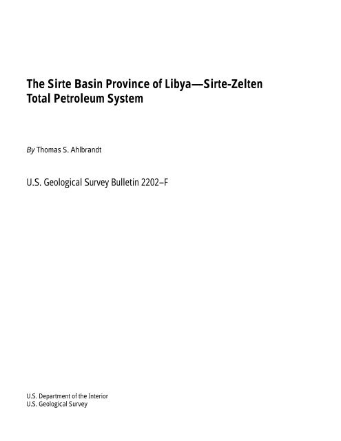
12 <strong>The</strong> <strong>Sirte</strong> <strong>Basin</strong> <strong>Province</strong> <strong>of</strong> Libya—<strong>Sirte</strong>-<strong>Zelten</strong> <strong>Total</strong> Petroleum System<br />
DEPTH, IN KILOMETERS<br />
144 123 103 82 62 41 21 0<br />
0<br />
1<br />
2<br />
3<br />
4<br />
5<br />
AGE, IN Ma<br />
Oil window<br />
Oil generation peak<br />
Gas window<br />
Lithology<br />
Formation<br />
Oligocene-<br />
Miocene<br />
Top<br />
Gialo<br />
Kheir<br />
<strong>Zelten</strong><br />
Kalash<br />
Sirt Shale<br />
Tagrifet<br />
Rachmat<br />
Etel<br />
USS<br />
VS<br />
MSS<br />
Basement<br />
Figure 10. Burial history curve for deepest portion <strong>of</strong> <strong>Sirte</strong> Trough (<strong>the</strong> Hameimat Trough), sou<strong>the</strong>astern <strong>Sirte</strong> <strong>Basin</strong> (modified from Bender and o<strong>the</strong>rs, 1996). USS, upper Sarir Sandstone;<br />
VS, variegated shale; MSS, middle Sarir Sandstone.
model were provided by Baird and o<strong>the</strong>rs (1996), who argued for<br />
normal listric extensional and growth faults in <strong>the</strong> <strong>Sirte</strong> <strong>Basin</strong> as<br />
opposed to <strong>the</strong> more nearly vertical faulting described by Harding<br />
(1984). <strong>The</strong> structural history is also complicated by <strong>the</strong> development<br />
<strong>of</strong> transfer or relay fault zones (transtensional and transpressional<br />
areas) that produced additional migration routes to<br />
reservoirs occupying horst blocks (Knytl and o<strong>the</strong>rs, 1996; Van<br />
Dijk and Eabadi, 1996).<br />
A contrasting view is <strong>of</strong>fered by Pratsch (1991), who<br />
believed that <strong>the</strong> <strong>Sirte</strong> <strong>Basin</strong> was an example <strong>of</strong> lateral migration<br />
and vertically stacked hydrocarbon systems isolated from each<br />
o<strong>the</strong>r. However, <strong>the</strong> oils in <strong>the</strong> various age reservoirs have been<br />
shown to be genetically linked (for example, El-Alami, 1996b;<br />
Gumati and Schamel, 1988; Gumati and o<strong>the</strong>rs, 1996). Internal<br />
seals occur between <strong>the</strong> major reservoirs, so if one were considering<br />
<strong>the</strong> oils at a reservoir or play level (regardless <strong>of</strong> <strong>the</strong> source<br />
<strong>of</strong> <strong>the</strong> oil) <strong>the</strong>n Pratsch’s concept is understandable. At <strong>the</strong> larger<br />
petroleum system level, on <strong>the</strong> o<strong>the</strong>r hand, <strong>the</strong> <strong>Sirte</strong> <strong>Basin</strong> is considered<br />
to be an example <strong>of</strong> a composite petroleum system in<br />
which petroleum sourced from Upper Cretaceous shales has<br />
migrated into multiple age reservoirs, dominantly vertically<br />
along normal, transfer, relay, or wrench faults adjacent to horsts.<br />
(See Harding, 1984; Baird and o<strong>the</strong>rs, 1996; Van Dijk and<br />
Eabadi, 1996; and Guiraud and Bosworth, 1997.)<br />
29°<br />
28°<br />
KALASH<br />
TROUGH<br />
CALANSCIO<br />
TROUGH<br />
EXPLANATION<br />
Basement high<br />
Oil field<br />
Upper Cretaceous<br />
source area<br />
Migration pathway<br />
Fault—Block on<br />
downthrown side<br />
0 10 20 30<br />
5A1-59<br />
CALANSCIO<br />
HIGH<br />
III1-59<br />
RACHMAT<br />
TROUGH<br />
40 KILOMETERS<br />
?<br />
Gialo<br />
01-80<br />
Source Rock<br />
Published studies support <strong>the</strong> interpretation that <strong>the</strong> <strong>Sirte</strong><br />
Shale (Upper Cretaceous, Campanian/Turonian) is <strong>the</strong> dominant<br />
source rock in <strong>the</strong> <strong>Sirte</strong> <strong>Basin</strong> petroleum province (Parsons and<br />
o<strong>the</strong>rs, 1980; Gumati and Schamel, 1988; Montgomery, 1994; El-<br />
Alami, 1996b; Ghori and Mohammed, 1996; Mansour and<br />
Magairhy, 1996; Macgregor and Moody, 1998; Ambrose, 2000).<br />
<strong>The</strong> thickness <strong>of</strong> <strong>the</strong> <strong>Sirte</strong> Shale ranges from a few hundred<br />
meters to as much as 900 m in <strong>the</strong> troughs. <strong>The</strong>se rocks are within<br />
<strong>the</strong> oil-generating window between depths <strong>of</strong> 2,700 and 3,400 m<br />
in <strong>the</strong> central and eastern <strong>Sirte</strong> <strong>Basin</strong> (Futyan and Jawzi, 1996;<br />
fig. 1). In figure 1, <strong>the</strong> outlines <strong>of</strong> <strong>the</strong> active pods <strong>of</strong> <strong>the</strong>rmally<br />
mature Upper Cretaceous source rock are drawn reflecting depth<br />
<strong>of</strong> burial <strong>of</strong> at least 2,865 m (9,400 feet) (Mikbel, 1979; Goudarzi,<br />
1980; Gumati and Kanes, 1985; Ibrahim, 1996), where conditions<br />
are considered favorable for oil generation (time temperature<br />
index (TTI)=15, vitrinite reflectance (Ro)=0.7; Gumati and<br />
Schamel, 1988; Montgomery, 1994; fig. 10). Parsons and o<strong>the</strong>rs<br />
(1980) reported total organic content (TOC) values ranging from<br />
0.5 to 4.0 percent with an average <strong>of</strong> 1.9 percent TOC for 129<br />
samples from <strong>the</strong> Upper Cretaceous source rocks. Baric and o<strong>the</strong>rs<br />
(1996) presented organic geochemical data for a 500 m section<br />
<strong>of</strong> <strong>Sirte</strong> Shale in wells on <strong>the</strong> <strong>Zelten</strong> Platform (sou<strong>the</strong>rn <strong>Sirte</strong><br />
Mesrab<br />
TI-80<br />
'EEI'-8O<br />
'A' pool<br />
'Z' pool<br />
UUI-65<br />
22°E<br />
Abu-<br />
Attifel<br />
HAMEIMAT<br />
TROUGH<br />
MESSLA<br />
HIGH<br />
SARIR<br />
TROUGH<br />
KKI-80<br />
HHI-80<br />
JJI-65 VVI-65<br />
UUI-80<br />
Messla<br />
Sarir-<br />
C-North<br />
Sarir-L-Field<br />
?<br />
Sarir-C-<br />
Main<br />
Figure 11. Postulated petroleum migration pathways for oil sourced from Upper Cretaceous shales, which also<br />
provide a regional seal in Sarir arm area <strong>of</strong> eastern <strong>Sirte</strong> <strong>Basin</strong>. Modified from Ambrose (2000).<br />
?<br />
<strong>Total</strong> Petroleum System 13
KALASH<br />
TROUGH<br />
GGG1-59<br />
Calanscio<br />
CALANSCIO<br />
TROUGH<br />
EXPLANATION<br />
Basement high<br />
Oil field<br />
Variegated shale<br />
source area<br />
Triassic source area<br />
Migration pathway<br />
Fault—Block on<br />
downthrown side<br />
RACHMAT<br />
TROUGH<br />
Gialo<br />
Mesrab<br />
SARIR TROUGH<br />
0 10 20 30<br />
<strong>Basin</strong>), in which total organic carbon (TOC) exceeds 0.5 percent<br />
and ranges as high as 3.5 percent; and hydrogen indices (HI) generally<br />
exceed 300 milligrams <strong>of</strong> hydrocarbon per gram <strong>of</strong> organic<br />
carbon (mg HC/g org.C) and reach as much as 600 mg HC/ g org.<br />
C). Organic matter is dominantly Type II, and <strong>the</strong> shales are oil<br />
prone. El-Alami (1996b) documented Upper Cretaceous source<br />
rocks ranging from 0.10 to 7.86 percent TOC in <strong>the</strong> Etel and<br />
Rachmat Formations (Cenomanian-Turonian) and recorded an<br />
average <strong>of</strong> 1.28 percent TOC for <strong>the</strong> <strong>Sirte</strong> Shale in <strong>the</strong> Abu Attifel<br />
(<strong>Sirte</strong> Graben) in <strong>the</strong> eastern <strong>Sirte</strong> <strong>Basin</strong>.<br />
Several o<strong>the</strong>r potential source rocks <strong>of</strong> ages o<strong>the</strong>r than Late<br />
Cretaceous have been considered; Burwood (1997), for example,<br />
identified source potential in four mudstones within deeper parts<br />
<strong>of</strong> <strong>the</strong> <strong>Sirte</strong> <strong>Basin</strong> including <strong>the</strong> <strong>Sirte</strong> Trough. <strong>The</strong>se potential<br />
source rocks occur in <strong>the</strong> <strong>Sirte</strong> Shale (Upper Cretaceous), a lower<br />
part <strong>of</strong> <strong>the</strong> Nubian Formation (Triassic–Lower Cretaceous), <strong>the</strong><br />
Harash Formation (Paleocene), and <strong>the</strong> Antelat Formation<br />
(Eocene, Gir Formation equivalent) (figs. 7, 8). Silurian age<br />
source rocks, <strong>the</strong> Tanezzuft Formation, may be potential in Algeria<br />
where present in deeper areas <strong>of</strong>f <strong>the</strong> flank <strong>of</strong> <strong>the</strong> ancestral<br />
<strong>Sirte</strong> Arch, and in <strong>the</strong> <strong>of</strong>fshore area where <strong>the</strong> Silurian may be<br />
present (Futyan and Jawzi, 1996; Klitzsch, 1996, Gumati and<br />
o<strong>the</strong>rs, 1996; fig. 6).<br />
Messla<br />
High<br />
UU1-65 JJ1-65 VV1-65<br />
40 KILOMETERS<br />
14 <strong>The</strong> <strong>Sirte</strong> <strong>Basin</strong> <strong>Province</strong> <strong>of</strong> Libya—<strong>Sirte</strong>-<strong>Zelten</strong> <strong>Total</strong> Petroleum System<br />
? ?<br />
'O'-80<br />
TI-80<br />
'A'-80<br />
'Z'-80<br />
Abu-<br />
Attifel<br />
Hameimat<br />
Trough<br />
'EE'-80<br />
KKI-80<br />
HHI-80<br />
UUI-80<br />
Messla<br />
Sarir-L<br />
Field<br />
Sarir-C-Main<br />
? ?<br />
Sarir-C-North<br />
Figure 12. Postulated pre-Upper Cretaceous source areas and migration pathways <strong>of</strong> minor nonmarine<br />
source rocks in eastern <strong>Sirte</strong> <strong>Basin</strong>. Modified from Ambrose (2000).<br />
?<br />
?<br />
?<br />
El-Alami (1996b) concluded that <strong>the</strong> mudstones within <strong>the</strong><br />
Nubian (Sarir) Formation (particularly in <strong>the</strong> Lower Cretaceous<br />
part) are mature enough to generate oil in <strong>the</strong> deep parts <strong>of</strong> <strong>the</strong><br />
<strong>Sirte</strong> <strong>Basin</strong>, but “<strong>the</strong>ir richness does not appear to be sufficient to<br />
cause generation <strong>of</strong> large amounts <strong>of</strong> hydrocarbons” (p. 347).<br />
Ambrose (2000) considered <strong>the</strong> Upper Cretaceous “Tethyan”<br />
shale system to be <strong>the</strong> dominant source rock, with particular<br />
emphasis on <strong>the</strong> <strong>Sirte</strong> Shale as being <strong>the</strong> primary source rock in<br />
<strong>the</strong> eastern <strong>Sirte</strong> <strong>Basin</strong>. He fur<strong>the</strong>r concluded that potential Triassic<br />
source rocks are <strong>of</strong> limited distribution but as yet are not well<br />
known (compare figs. 11 and 12).<br />
Geochemical data based on analyses <strong>of</strong> 81 oils from Libya<br />
(GeoMark, 1998) indicate that <strong>the</strong> <strong>Sirte</strong> Shale is <strong>the</strong> dominant<br />
source rock in <strong>the</strong> <strong>Sirte</strong> <strong>Basin</strong> province. <strong>Sirte</strong> oils are low sulfur<br />
and <strong>of</strong> relatively high gravity; for example, median oil gravity is<br />
36°<br />
, ranging from 30°<br />
to 43°<br />
API, and median sulfur content is<br />
0.3 percent (Petroconsultants, 1996; GeoMark, 1998; fig. 13).<br />
3<br />
<strong>The</strong> oil generally has low gas/oil ratios (median 300 ft / barrel,<br />
U.S. Geological Survey World Energy Assessment Team, 2000).<br />
Although as many as four oil families can be identified, all<br />
but three <strong>of</strong> <strong>the</strong> 81 samples analyzed by GeoMark (1998) can be<br />
linked to a single oil family (Jerry Clayton, written commun.,<br />
1998) based on (1) pristane/phytane ratios (>1.0) to δC13<br />
aromatic<br />
content, (2) sulfur content, (3) API gravity, and (4) δC13<br />
?
PRISTANE / PHYTANE RATIO<br />
PERCENT SULFUR<br />
2.5<br />
2<br />
1.5<br />
1<br />
0.5<br />
0<br />
5<br />
4.5<br />
4<br />
3.5<br />
3<br />
2.5<br />
2<br />
1.5<br />
1<br />
0.5<br />
0<br />
1<br />
4<br />
7<br />
10<br />
13<br />
16<br />
19<br />
22<br />
25<br />
28<br />
<strong>Sirte</strong> <strong>Basin</strong> Oils<br />
1<br />
4<br />
7<br />
10<br />
13<br />
16<br />
19<br />
22<br />
25<br />
28<br />
31<br />
34<br />
37<br />
40<br />
43<br />
46<br />
49<br />
52<br />
55<br />
58<br />
61<br />
64<br />
67<br />
70<br />
73<br />
76<br />
79<br />
API GRAVITY, IN DEGREES<br />
60<br />
50<br />
40<br />
30<br />
20<br />
10<br />
0<br />
1<br />
4<br />
7<br />
10<br />
13<br />
16<br />
19<br />
22<br />
25<br />
28<br />
31<br />
31<br />
34<br />
SAMPLES<br />
37<br />
40<br />
43<br />
46<br />
49<br />
52<br />
SIRTE BASIN OILS<br />
34<br />
SIRTE BASIN OILS<br />
Figure 13. Oil geochemistry plots utilizing data from GeoMark (1998) for 81 oil samples from 55 fields in <strong>Sirte</strong> <strong>Basin</strong>.<br />
ratios; B,<br />
Sulfur percentages; C,<br />
API gravity.<br />
37<br />
40<br />
43<br />
46<br />
49<br />
52<br />
55<br />
55<br />
58<br />
58<br />
61<br />
61<br />
64<br />
64<br />
67<br />
67<br />
70<br />
70<br />
73<br />
73<br />
76<br />
76<br />
79<br />
79<br />
A<br />
Series1<br />
B<br />
Series1<br />
C<br />
Series1<br />
A,<br />
Pristane/phytane<br />
<strong>Total</strong> Petroleum System 15
0<br />
50<br />
100<br />
150<br />
200<br />
250<br />
300<br />
350<br />
400<br />
450<br />
500<br />
550<br />
600<br />
GEOLOGIC<br />
TIME<br />
SCALE<br />
PETROLEUM<br />
SYSTEM EVENTS<br />
Neogene Plio<br />
Mio<br />
24 Olig<br />
Paleogene Eoc<br />
Pal<br />
65<br />
Cretaceous<br />
144<br />
Jurassic<br />
206<br />
Triassic<br />
248<br />
Permian<br />
290<br />
Pennsylvanian<br />
323<br />
Mississipian<br />
363<br />
Devonian<br />
408<br />
Silurian<br />
439<br />
Ordovician<br />
510<br />
Cambrian<br />
570<br />
Precambrian<br />
L<br />
E<br />
M<br />
L<br />
L<br />
E M<br />
L<br />
16 <strong>The</strong> <strong>Sirte</strong> <strong>Basin</strong> <strong>Province</strong> <strong>of</strong> Libya—<strong>Sirte</strong>-<strong>Zelten</strong> <strong>Total</strong> Petroleum System<br />
L<br />
E<br />
L<br />
M<br />
E<br />
E<br />
E<br />
L<br />
M<br />
E<br />
L<br />
E<br />
L<br />
M<br />
E<br />
L<br />
M<br />
E<br />
ROCK UNIT<br />
SOURCE ROCK<br />
RESERVOIR ROCK<br />
SEAL ROCK<br />
OVERBURDEN ROCK<br />
TRAP FORMATION<br />
M<br />
A<br />
G<br />
H<br />
Z<br />
S<br />
R<br />
N<br />
Hercynian Erosion<br />
G<br />
?<br />
TZ<br />
?<br />
Fractures<br />
ACCUMULATION<br />
MIGRATION-<br />
GENERATION-<br />
PRESERVATION<br />
CRITICAL MOMENT<br />
Post Rift<br />
Syn-Rift<br />
Pre-Rift<br />
Figure 14. <strong>Sirte</strong>-<strong>Zelten</strong> <strong>Total</strong> Petroleum System events chart. Significant rock units noted on chart include GH, Gargaf/H<strong>of</strong>ra Formation—Cambrian-Ordovician sandstones;<br />
TZ, Tanezzuft Shale—Silurian; N, Nubian or Sarir Sandstone—Jurassic–Early Cretaceous; R, Rakb Group—Cretaceous, Turonian-Campanian; S, <strong>Sirte</strong> Shale Member <strong>of</strong> Rakb<br />
Group, primary source rock—Campanian; Z, <strong>Zelten</strong> Group carbonates—Paleocene; H, Hon Evaporite Member <strong>of</strong> Gir Formation—Eocene-Ypresian; G, Gialo Formation carbonates—middle<br />
Eocene–Lutetian; A, Arida Formation—Oligocene; M, Marada Formation—Miocene.
saturates vs. δC13<br />
aromatic characteristics (fig. 13). El-Alami deposited within <strong>the</strong> rift basins, and some formed significant<br />
(1996b), Jerry Clayton (written commun., 1998), and Ambrose stratigraphic traps adjacent to horst blocks such as Messla and<br />
(2000), concluding that <strong>the</strong> Upper Cretaceous <strong>Sirte</strong> Shale is by far Sarir fields (Ambrose, 2000; figs. 15–18).<br />
<strong>the</strong> dominant source <strong>of</strong> oil for <strong>the</strong> <strong>Sirte</strong> <strong>Basin</strong> province, also rec- Northwest-sou<strong>the</strong>ast-trending horst and graben structures<br />
ognized that <strong>the</strong>re may be contributions from o<strong>the</strong>r Upper Creta- formed in <strong>the</strong> <strong>Sirte</strong> arm <strong>of</strong> <strong>the</strong> triple junction from <strong>the</strong> Late Creceous<br />
source rocks in a composite total petroleum system, <strong>the</strong> taceous to <strong>the</strong> end <strong>of</strong> <strong>the</strong> Paleocene in <strong>the</strong> central and western<br />
<strong>Sirte</strong>-<strong>Zelten</strong>. (See Glossary in U.S. Geological Survey World <strong>Sirte</strong> <strong>Basin</strong>, with <strong>the</strong> younger trends extending <strong>of</strong>fshore (fig. 2;<br />
Energy Assessment Team, 2000.)<br />
Van der Meer and Cloetingh, 1996; Guiraud and Bosworth,<br />
<strong>The</strong> remaining three oils analyzed by GeoMark (1998) 1997). Overburden was largely deposited during <strong>the</strong> post-rift sed-<br />
appear to be younger (Tertiary, most probably reflecting a Paleimentation stage (Oligocene and younger). Pre-rift and early synocene/Eocene<br />
source); however, <strong>the</strong>y may also reflect biodegrarift deposition was largely clastic whereas later syn-rift deposidation<br />
<strong>of</strong> <strong>the</strong> Upper Cretaceous source (Jerry Clayton, written tion was dominated by carbonate deposition. According to Hal-<br />
commun., 1998).<br />
lett and El Ghoul (1996) (1) <strong>the</strong> deepest troughs, such as <strong>the</strong> <strong>Sirte</strong><br />
Tertiary petroleum systems may possibly exist in <strong>the</strong> deeper (also called Ajdabiya Graben, fig. 2), have more than 7,000 m <strong>of</strong><br />
part <strong>of</strong> <strong>the</strong> <strong>Sirte</strong> <strong>Basin</strong> (for example, <strong>the</strong> <strong>Sirte</strong> or Ajdabiya graben sediment, <strong>of</strong> which 5,500 m is <strong>of</strong> Tertiary age (fig. 5); and (2) 80<br />
<strong>of</strong> Baird and o<strong>the</strong>rs, 1996, figs. 1, 6) and in <strong>of</strong>fshore areas. A dis- percent <strong>of</strong> <strong>the</strong> drilling in <strong>the</strong> province has been on platform<br />
tinctly different oil—lower gravity (
29°<br />
28°<br />
KALASH<br />
TROUGH<br />
300<br />
600<br />
A<br />
600<br />
?900<br />
?600<br />
300<br />
300<br />
CALANSCIO<br />
5A1-59<br />
900<br />
?1200<br />
21°E 22°E<br />
TROUGH<br />
GIALO FIELD<br />
GGG1-59<br />
CALANSCIO HIGH<br />
'O' Pool<br />
300<br />
III 1-59<br />
QUADEEM<br />
FIELD<br />
Barr and Weegar, 1972; Brennan, 1992). Production is enhanced<br />
by fracturing as noted by Roberts (1970) at Amal field and Brennan<br />
(1992) at Raguba field. In a few areas, Silurian, Devonian,<br />
and Carboniferous clastics are preserved and are potential reservoirs<br />
(fig. 6).<br />
<strong>The</strong> Nubian (Sarir) deposits, ranging from Triassic/Late<br />
Jurassic? to Early Cretaceous in age, constitute <strong>the</strong> second major<br />
megacycle in <strong>the</strong> <strong>Sirte</strong> <strong>Basin</strong> province (Montgomery, 1994; El-<br />
Hawat and o<strong>the</strong>rs, 1996; this report, figs. 7, 8) and are <strong>the</strong> producing<br />
interval in at least 72 fields in <strong>the</strong> eastern <strong>Sirte</strong> <strong>Basin</strong> (Petroconsultants,<br />
1996). <strong>The</strong>se clastic strata are <strong>the</strong> primary reservoirs<br />
in several giant fields including Messla, Sarir, Amal, and Abu<br />
Attifel fields (fig. 1). <strong>The</strong> reservoirs are continental sandstones,<br />
900<br />
600<br />
300<br />
'T' Pool<br />
MESRAB FIELD<br />
18 <strong>The</strong> <strong>Sirte</strong> <strong>Basin</strong> <strong>Province</strong> <strong>of</strong> Libya—<strong>Sirte</strong>-<strong>Zelten</strong> <strong>Total</strong> Petroleum System<br />
300<br />
WESTERN MARGIN<br />
300<br />
'EE' Pool<br />
'A' Pool<br />
'Z' Pool<br />
NORTHERN MARGIN<br />
MESSLA<br />
HIGH<br />
ABU ATTIFEL FIELD<br />
2100<br />
SOUTHERN MARGIN<br />
1200 1500<br />
2400<br />
1800<br />
HAMEIMAT TROUGH<br />
EASTERN MARGIN<br />
300<br />
900<br />
'KK' Pool<br />
'HH' Pool<br />
'UU' Pool<br />
1500<br />
1200<br />
both alluvial and eolian deposits, although Ambrose (2000) identified<br />
significant reservoirs in <strong>the</strong> Upper Sarir Sandstone that are<br />
fan delta deposits. El-Hawat and o<strong>the</strong>rs (1996) divided <strong>the</strong><br />
Nubian Sandstone into three members that reflect <strong>the</strong> interfingering<br />
<strong>of</strong> alluvial deposits with Tethyan marine sediments as <strong>the</strong><br />
<strong>Sirte</strong> rift system began to develop in Neocomian-Barremian time<br />
(El-Hawat, 1996; Ambrose, 2000). East-west-trending sinistral<br />
shear zones (strike-slip) strongly controlled deposition <strong>of</strong> <strong>the</strong><br />
Nubian sequence according to Anketell (1996) and Abdulghader<br />
(1996), and Ambrose (2000) documented <strong>the</strong> sedimentological<br />
pattern and heterogeneities within <strong>the</strong> Nubian sequence that may<br />
have enhanced hydrocarbon potential <strong>of</strong> <strong>the</strong> Sarir Sandstone in<br />
<strong>the</strong> eastern <strong>Sirte</strong> <strong>Basin</strong>.<br />
A'<br />
900<br />
R3-82<br />
600<br />
300<br />
MESSLA FIELD<br />
RACHMAT<br />
TROUGH<br />
SARIR-L FIELD<br />
UU1 Pool VV1 Pool<br />
JJ1 Pool<br />
SARIR-C-NORTH<br />
SARIR TROUGH<br />
600<br />
C280-65<br />
EXPLANATION<br />
Sarir zero edge<br />
Y1-65<br />
SARIR-C-MAIN<br />
300 300 m interval isopach<br />
Sarir Sandstone<br />
Pre-Sarir basement<br />
Oil field<br />
Fault—Block on downthrown<br />
side<br />
0 50 KILOMETERS<br />
27°<br />
Figure 15. Tectonic elements and oil fields in eastern <strong>Sirte</strong> <strong>Basin</strong>. Sarir Sandstone isopachs are shown in main depocenters (modified from<br />
Ambrose, 2000). Cross section A–A'<br />
shown in figure 16.<br />
300
WEST (bend in section)<br />
EAST<br />
CALANSCIO AREA SARIR-C Field HAMEIMAT TROUGH<br />
5A1-59 JJ1-65 C280-65 R3-82<br />
A GR SLS GR SLS GR<br />
GR LLD A'<br />
EXPLANATION<br />
Upper Sarir Sandstone (USS)<br />
Variegated shale<br />
Middle Sarir Sandstone (MSS)<br />
Red shale (RS)<br />
Lower Sarir Sandstone (LSS)<br />
Basement<br />
Unconformity<br />
<strong>The</strong> Nubian (Sarir) Formation is highly variable in thickness<br />
(maximum as much as 2,500 m); that variation reflects <strong>the</strong> infilling<br />
<strong>of</strong> low areas (grabens) that partially extend across some Cretaceous<br />
horsts and formed prolific stratigraphic/structural traps<br />
such as Sarir field (Sanford, 1970; Lewis, 1990) and Messla field<br />
(Clifford and o<strong>the</strong>rs, 1980; Koscec and Gherryo, 1996; Ambrose,<br />
2000; this report, figs. 15–18). Lewis (1990) suggested that Sarir<br />
field is a complex <strong>of</strong> individual fields, Sarir C alone containing<br />
6.5 BBO EUR. A cross section from Messla field by Ambrose<br />
(2000), shown in figures 15–18, portrays <strong>the</strong> major stratigraphic<br />
truncation that occurs in <strong>the</strong> Sarir Sandstone across <strong>the</strong> structural<br />
high and <strong>the</strong> opportunity for additional exploration targets near<br />
Scale<br />
150 m<br />
Figure 16. Stratigraphic cross section A–<br />
A'<br />
in Calanscio-Hameimat Trough (line <strong>of</strong> section shown in fig. 15). Note<br />
subdivisions (members) within <strong>the</strong> Sarir Sandstone and <strong>the</strong> combined structural-stratigraphic trap at Sarir-C field<br />
(modified from Ambrose, 2000).<br />
<strong>the</strong>se terminations, such as in <strong>the</strong> Upper Sarir fan delta deposits.<br />
Abdulghader (1996) documented average porosity <strong>of</strong> 27.5 percent<br />
for <strong>the</strong> main Sarir reservoir. Lewis (1990) documented average<br />
porosity <strong>of</strong> 18–19 percent, and average permeability <strong>of</strong> 200–<br />
300 millidarcies at Sarir field.<br />
<strong>The</strong> third megacycle, largely composed <strong>of</strong> marine deposits,<br />
<strong>of</strong> Late Cretaceous and early Tertiary ages, encompasses <strong>the</strong><br />
entire <strong>Sirte</strong> <strong>Basin</strong>, and depositionally followed <strong>the</strong> early nonmarine<br />
graben fill <strong>of</strong> <strong>the</strong> Sarir (Nubian) sediments in <strong>the</strong> eastern <strong>Sirte</strong><br />
<strong>Basin</strong>. As summarized in Montgomery (1994), two major Upper<br />
Cretaceous transgressive and regressive cycles and two Paleocene<br />
cycles <strong>of</strong> sedimentation characterize this later syn-rift fill<br />
<strong>Total</strong> Petroleum System 19
WEST EAST<br />
002-65 001-65 UU1-65 JJ1-65 VV1-65<br />
(Messla Field)<br />
HH11-65<br />
Sarir Sandstone<br />
SW NE<br />
USS<br />
SARIR TROUGH<br />
Approx<br />
2000 m<br />
2500 m<br />
3000 m<br />
0 20 KILOMETERS<br />
TERTIARY<br />
UPPER CRETACEOUS<br />
LSS<br />
Tethyan<br />
shales<br />
Logs used: GR(LHS), LLD(RHS)<br />
Tethyan Shale sequence<br />
Upper Sarir Sandstone (USS)<br />
Variegated shale<br />
Middle Sarir Sandstone (MSS)<br />
WEST<br />
002-65<br />
UU1-65<br />
JJ1-65<br />
VV1-65<br />
EAST<br />
HH11-65<br />
Red shale (RS)<br />
001-65<br />
Producing well<br />
Lower Sarir Sandstone (LSS)<br />
Basement<br />
Unconformity<br />
Dry hole<br />
0 10 20 KILOMETERS<br />
Figure 17. East-west structural cross section across western margin <strong>of</strong> <strong>the</strong> Messla High (modified from Ambrose,<br />
2000). Note that faulting caused erosion <strong>of</strong> different members <strong>of</strong> <strong>the</strong> Sarir Sandstone along <strong>the</strong> highs.<br />
Top Sarir Sandstone<br />
MSS<br />
MSS<br />
Red shale<br />
Red shale<br />
Thin silty variegated shale<br />
Unnamed Pre-Sarir<br />
(? Triassic)<br />
Tarmat<br />
UU1 Field<br />
USS<br />
USS = Upper Sarir Sandstone<br />
MSS = Middle Sarir Sandstone<br />
LSS = Lower Sarir Sandstone<br />
20 <strong>The</strong> <strong>Sirte</strong> <strong>Basin</strong> <strong>Province</strong> <strong>of</strong> Libya—<strong>Sirte</strong>-<strong>Zelten</strong> <strong>Total</strong> Petroleum System<br />
MESSLA HIGH HAMEIMAT TROUGH<br />
USS<br />
Tarmat<br />
MSS MSS<br />
Red<br />
shale<br />
Basement<br />
Variegated<br />
shale<br />
UPPER CRETACEOUS<br />
Messla Field<br />
Red shale<br />
Top Sarir Sandstone<br />
USS Truncation Play<br />
USS<br />
Variegated shale<br />
Red shale<br />
Figure 18. Schematic structural cross section from Sarir Trough across Messla High and into Hameimat Trough<br />
showing hydrocarbon habitat <strong>of</strong> <strong>the</strong> Sarir Sandstone (modified from Ambrose, 2000). Note truncation and stratigraphic<br />
trap potential in various members <strong>of</strong> <strong>the</strong> Sarir Sandstone. Scale is approximate.<br />
LSS<br />
Top Tagrifet<br />
Rachmat Fm.<br />
Etel Fm.<br />
Top Sarir SS.<br />
MSS<br />
RS<br />
LSS<br />
Basement<br />
0 m<br />
150 m<br />
300 m<br />
MSS<br />
LSS
sequence (fig. 7). Sedimentation was largely controlled by northwest-sou<strong>the</strong>ast-oriented<br />
horst and graben structures. Erosion<br />
along <strong>the</strong> <strong>Sirte</strong> Arch in <strong>the</strong> central <strong>Sirte</strong> <strong>Basin</strong> has removed evidence<br />
<strong>of</strong> <strong>the</strong> older sediments, including <strong>the</strong> Lower Cretaceous<br />
clastics, although <strong>the</strong> hydrocarbon potential is largely undeveloped<br />
in structurally low areas within <strong>the</strong> central <strong>Sirte</strong> <strong>Basin</strong>.<br />
<strong>The</strong> first Upper Cretaceous depositional cycle consists, in<br />
ascending order, <strong>of</strong> (1) a transgressive sequence comprising <strong>the</strong><br />
Bahi Formation; (2) carbonates, commonly represented by dolomites<br />
<strong>of</strong> <strong>the</strong> Lidam Formation; and (3) a regressive sequence <strong>of</strong><br />
carbonates, evaporites, and shales that now characterize <strong>the</strong> Etel<br />
Formation (a potential source rock interval, figs. 7, 8). A second<br />
transgression resulted in <strong>the</strong> deposition <strong>of</strong> shallow marine sediments<br />
(Rachmat Formation) followed by deposition <strong>of</strong> deep<br />
marine sediments (<strong>Sirte</strong> Shale). Shallower water sequences in <strong>the</strong><br />
younger Cretaceous Kalash Limestone are in turn overlain by<br />
shales (Hagfa Shale, similar lithologically to <strong>the</strong> <strong>Sirte</strong> Shale) and<br />
carbonates (Beda Formation) <strong>of</strong> Paleocene age. <strong>The</strong> Beda Formation<br />
is a significant reservoir, commonly consisting <strong>of</strong> calcilutite,<br />
calcarenites, oolites, and skeletal debris along <strong>the</strong> south margin <strong>of</strong><br />
<strong>the</strong> <strong>Sirte</strong> <strong>Basin</strong>; and significant production has taken place in<br />
fields such as Dahra and H<strong>of</strong>ra and in many fields on <strong>the</strong> Az<br />
Zahrah (Dahra and Beda) and <strong>Zelten</strong> (Al Janamah) platforms<br />
(Bebout and Poindexter, 1975; Brady and o<strong>the</strong>rs, 1980; this<br />
report, figs. 2, 5).<br />
Continued sedimentation during Paleocene time resulted in<br />
deposition <strong>of</strong> <strong>the</strong> <strong>Zelten</strong> Formation, which is notable for its carbonate<br />
build-ups and reefs that grew on <strong>the</strong> structurally elevated<br />
horsts such as <strong>the</strong> Az Zahrah (Beda and Dahra) Platform and <strong>the</strong><br />
<strong>Zelten</strong> (Al Janamah) Platform. As previously discussed, <strong>the</strong><br />
<strong>Zelten</strong> Formation is <strong>the</strong> single largest reservoir interval in <strong>the</strong><br />
<strong>Sirte</strong> <strong>Basin</strong> province. Carbonates, mostly Upper Cretaceous,<br />
Paleocene, and Eocene, are <strong>the</strong> dominant reservoirs in 150 fields<br />
encompassed in <strong>the</strong> area shown as assessment unit 20430102 in<br />
figure 1. Carbonate deposition in <strong>the</strong> late syn-rift sequences took<br />
place particularly during Paleocene time on <strong>the</strong> platforms along<br />
<strong>the</strong> south margin <strong>of</strong> <strong>the</strong> <strong>Sirte</strong> <strong>Basin</strong>. Carbonates are important reservoirs<br />
in many giant oil fields such as Intistar, Beda, Defa, Waha,<br />
Haram, <strong>Zelten</strong> (Nasser), H<strong>of</strong>ra, and Nafoora (Belazi, 1989;<br />
Roohi, 1996b; figs. 1, 19).<br />
<strong>The</strong> upper Paleocene regression <strong>of</strong> this megacycle is represented<br />
by <strong>the</strong> deposition <strong>of</strong> shallow marine carbonates (Harash<br />
and Kheir Formations) followed by transgressive deposits <strong>of</strong> <strong>the</strong><br />
Facha Dolomite (fig. 7). <strong>The</strong>se were ultimately overlain and subsequently<br />
sealed in a final regression <strong>of</strong> this megacycle by <strong>the</strong><br />
evaporites <strong>of</strong> <strong>the</strong> Gir Formation (Hon Evaporites Member). <strong>The</strong><br />
carbonates in <strong>the</strong> upper part <strong>of</strong> <strong>the</strong> Gir Formation are <strong>the</strong> stratigraphically<br />
youngest potential reservoirs, containing about 1 percent<br />
<strong>of</strong> <strong>the</strong> proven hydrocarbon reserves in <strong>the</strong> <strong>Sirte</strong> <strong>Basin</strong>.<br />
Stratigraphic traps within <strong>the</strong> Eocene strata, including nummulitic<br />
banks and dolomite zones in <strong>the</strong> Facha Dolomite (fig. 7) as<br />
well as possible indigenous, high sulfur (3 percent), heavy oil<br />
shows in tests near Beda-Haram, between Intisar and Amal fields,<br />
and in <strong>the</strong> eastern <strong>Sirte</strong> <strong>Basin</strong> (Ghori and Mohammed, 1996, fig.<br />
1) indicate that <strong>the</strong> Eocene sequence may be an exploration target<br />
in <strong>the</strong> deeper portions <strong>of</strong> onshore grabens and <strong>of</strong>fshore<br />
(Abugares, 1996).<br />
<strong>The</strong> final megacycle represents <strong>the</strong> post-rift fill <strong>of</strong> Oligocene<br />
and younger age and is <strong>of</strong> minor potential for hydrocarbons<br />
because no commercial shows <strong>of</strong> hydrocarbons have been found<br />
in rocks younger than Eocene.<br />
In general, clastic reservoirs are dominantly <strong>of</strong> Early Cretaceous<br />
and older (pre-rift, early syn-rift) ages in <strong>the</strong> eastern <strong>Sirte</strong><br />
<strong>Basin</strong>, whereas carbonate reservoirs are dominantly uppermost<br />
Cretaceous, Paleocene, and Eocene (syn-rift or late syn-rift) elsewhere<br />
in <strong>the</strong> <strong>Sirte</strong> <strong>Basin</strong> province. <strong>The</strong> assessment units, discussed<br />
later, were delineated using <strong>the</strong>se criteria.<br />
Seal Rock<br />
Although carbonates and shales dominate much <strong>of</strong> <strong>the</strong> Tertiary<br />
sequence, <strong>the</strong> evaporite and salt deposits <strong>of</strong> <strong>the</strong> Eocene Gir<br />
Formation (Hon Evaporites Member; Abugares, 1996; fig. 7) are<br />
<strong>of</strong> <strong>the</strong> utmost importance to petroleum accumulation in <strong>the</strong> <strong>Sirte</strong><br />
<strong>Basin</strong> province because <strong>the</strong>y form essential seals for <strong>the</strong> hydrocarbons<br />
migrating out <strong>of</strong> <strong>the</strong> Upper Cretaceous into reservoirs <strong>of</strong><br />
many ages along <strong>the</strong> faulted horsts and grabens (Harding, 1984;<br />
Montgomery, 1994; Abugares, 1996; figs. 7, 9). <strong>The</strong> formation<br />
shows rapid changes in thickness, reaching a maximum <strong>of</strong> 1,305<br />
m in <strong>the</strong> Marada Trough. It contains dolomite, anhydrite, and<br />
halite, but also shows abrupt lithologic changes. In some areas,<br />
halite forms 35 percent <strong>of</strong> <strong>the</strong> total section, as in <strong>the</strong> Zallah<br />
Trough (Abugares, 1996), but <strong>the</strong> salt component decreases dramatically<br />
around <strong>the</strong> onshore margins <strong>of</strong> <strong>the</strong> <strong>Sirte</strong> <strong>Basin</strong>, which<br />
might help to explain <strong>the</strong> absence <strong>of</strong> significant oil fields near <strong>the</strong><br />
outcrop belt and <strong>the</strong> high risk <strong>of</strong> drilling in <strong>the</strong> <strong>of</strong>fshore area.<br />
Trap Style<br />
Shown on <strong>the</strong> oil and gas field map for <strong>the</strong> <strong>Sirte</strong> <strong>Basin</strong> (fig. 1)<br />
are <strong>the</strong> 237 fields that were considered in this study. Of <strong>the</strong>se<br />
fields, 221 are oil fields and 16 are gas fields (Petroconsultants,<br />
1996). Known petroleum volumes <strong>of</strong> 43.1 BBOE rank <strong>the</strong> <strong>Sirte</strong><br />
<strong>Basin</strong> province as <strong>the</strong> 13th in <strong>the</strong> world, exclusive <strong>of</strong> <strong>the</strong> U.S. (15th<br />
if U.S. provinces are included). It is dominantly an oil province<br />
with 36.7 BBO, 37.7 TCFG (6.3 BBOE), and 0.1 BB NGL (Klett<br />
and o<strong>the</strong>rs, 1997). Twenty-three fields are major oil fields (>100<br />
MMBOE), and 16 fields rank as giant oil fields (>500 MMBOE).<br />
<strong>The</strong> dominant trap style is structural (84 percent), with <strong>the</strong><br />
remainder considered stratigraphic or a combination <strong>of</strong> <strong>the</strong> two<br />
(Clifford and o<strong>the</strong>rs, 1980). As examples <strong>of</strong> combined traps,<br />
bioherm developments in <strong>the</strong> Paleocene <strong>Zelten</strong> Group are found<br />
on horst blocks, and clastic stratigraphic traps such as at Sarir or<br />
Messla field are superimposed on structures (figs. 15–18). Similarly,<br />
bioherm development in Paleocene sediments <strong>of</strong> <strong>the</strong> <strong>Zelten</strong><br />
Group in <strong>the</strong> <strong>Zelten</strong> field (Bebout and Poindexter, 1975), which<br />
occurs on a major horst, is shown to represent <strong>the</strong> carbonate<br />
assessment unit (20430102). An example <strong>of</strong> such a carbonate<br />
field is shown for Idris field in <strong>the</strong> nor<strong>the</strong>astern <strong>Sirte</strong> <strong>Basin</strong> (Terry<br />
and Williams, 1969; this report, fig. 19).<br />
Petroleum Assessment<br />
<strong>The</strong> discovery history <strong>of</strong> <strong>the</strong> <strong>Sirte</strong> <strong>Basin</strong> started relatively<br />
late (as discussed earlier) because Libya did not really become an<br />
Petroleum Assessment 21
22 <strong>The</strong> <strong>Sirte</strong> <strong>Basin</strong> <strong>Province</strong> <strong>of</strong> Libya—<strong>Sirte</strong>-<strong>Zelten</strong> <strong>Total</strong> Petroleum System<br />
VERTICAL<br />
SCALE<br />
ft m<br />
9000<br />
10000<br />
11000<br />
2700<br />
2800<br />
2900<br />
3000<br />
3100<br />
3200<br />
3300<br />
VERTICAL EXAGGERATION =1X2.5<br />
HORIZONTAL SCALE<br />
0 1000 METERS<br />
A9-103 A12-103 A20-103 A18-103<br />
Non-reef well GIR FORMATION A22-103 A7-103<br />
Non-reef<br />
5740 ft (1750 m)<br />
6560 ft (2000 m) well<br />
out <strong>of</strong> section<br />
out <strong>of</strong> section<br />
9000 ft (2743 m)<br />
Ο<br />
< 20%<br />
Ο<br />
Ο > 25% 20-25%<br />
Ο > 25%<br />
Ο 20-25%<br />
Coralline<br />
Biomicrite<br />
Ο < 20%<br />
Ο > 25%<br />
CORAL REEF MEMBER<br />
Ο < 20%<br />
Ο > 25%<br />
Reef Limestone<br />
Ο 20-25%<br />
ALGAL FORAMINIFERAL MEMBER<br />
Porosity Transition Zone<br />
EXPLANATION<br />
Sealing evaporites<br />
Shale and marl<br />
Argillaceous limestone<br />
Ο<br />
Limestone<br />
Bio-facies zones<br />
Porosity zones<br />
Porosity<br />
Ο < 20%<br />
Ο 20-25%<br />
A15-103<br />
Ο < 20%<br />
L. <strong>Zelten</strong><br />
9000 ft (2743 m)<br />
Upper<br />
Kheir<br />
Marl<br />
Lower<br />
Kheir<br />
Marl<br />
Lower<br />
<strong>Zelten</strong><br />
Carbonates<br />
Heira Shale<br />
Heira Carbonate<br />
Figure 19. Stratigraphic cross section through <strong>Zelten</strong> Formation (Paleocene) bioherms, Idris “A” field, nor<strong>the</strong>astern <strong>Sirte</strong> <strong>Basin</strong>, representing reservoirs in carbonate assessment unit (modified<br />
from Terry and Williams, 1969).<br />
Middle Upper<br />
Ypresian STAGE<br />
Land. Landenian<br />
P A L E O C E N E E O C E N E SERIES<br />
Lower<br />
Landenian
independent country until 1951. Giant fields were found between<br />
1956 and 1961, including Amal, Sarir, Raguba, and <strong>Zelten</strong> platform<br />
fields (Carmalt and St. John, 1986; Brennan, 1992; fig. 1).<br />
Three distinct discovery segments are seen on cumulative oil<br />
plots—a steep segment from 1956 to 1961, an intermediate segment<br />
from 1962 to 1970, and a nearly flat segment since 1970<br />
(fig. 20). <strong>The</strong> discovery process has been interrupted by political<br />
events, including sanctions against Libya that prohibited U.S.<br />
company involvement in exploration in Libya since 1981. Montgomery<br />
(1994) and MacGregor and Moody (1998) have contended<br />
that <strong>the</strong> <strong>Sirte</strong> <strong>Basin</strong> has a significant future potential, citing<br />
<strong>the</strong> fact that <strong>the</strong> North Sea is three times more heavily explored<br />
than <strong>the</strong> <strong>Sirte</strong> <strong>Basin</strong> as a comparison.<br />
Four assessment units within <strong>the</strong> <strong>Sirte</strong>-<strong>Zelten</strong> total petroleum<br />
system (two established, two hypo<strong>the</strong>tical) were defined for<br />
<strong>the</strong> present study; <strong>the</strong>y are as follows:<br />
Sou<strong>the</strong>ast <strong>Sirte</strong> Clastics (20430101) is an established unit<br />
and includes Cretaceous and older (Cambrian-Ordovician,<br />
Precambrian) fields in <strong>the</strong> onshore area <strong>of</strong> <strong>the</strong> eastern <strong>Sirte</strong> <strong>Basin</strong><br />
(fig. 1).<br />
Central <strong>Sirte</strong> Carbonates (20430102) is an established unit<br />
and contains fields producing from carbonates <strong>of</strong> <strong>the</strong> Upper<br />
Cretaceous, Paleocene, and Eocene platforms, mostly onshore,<br />
with potential for production to water depths <strong>of</strong> about 200 m<br />
(fig.1). Offshore production has been established in <strong>the</strong> water<br />
depth range <strong>of</strong> 200 m or less in <strong>the</strong> Gulf <strong>of</strong> <strong>Sirte</strong> (figs. 1, 2).<br />
CUMULATIVE KNOWN OIL VOLUME, IN MMBO<br />
25,000<br />
20,000<br />
15,000<br />
10,000<br />
5,000<br />
Some minor calcarenite Middle Cretaceous production is also<br />
included in <strong>the</strong>se fields.<br />
Offshore <strong>Sirte</strong> Hypo<strong>the</strong>tical (20430103) extends from water<br />
depths <strong>of</strong> 200 m to 2,000 m and does not contain any established<br />
fields, although hydrocarbon shows have been encountered. Both<br />
positive and negative petroleum factors are recognized for this<br />
area. On <strong>the</strong> positive side is <strong>the</strong> likely presence <strong>of</strong> <strong>the</strong>rmally<br />
mature Upper Cretaceous and possibly Silurian and Eocene<br />
source rocks, and <strong>the</strong> likelihood <strong>of</strong> both carbonate and clastic reservoirs<br />
being present. On <strong>the</strong> negative side, tectonic complexity is<br />
considerable, including a subduction zone and numerous extrusive<br />
magmatic features that may have compromised preservation<br />
<strong>of</strong> <strong>the</strong> total petroleum system (figs. 4, 5). To address such circumstances<br />
(and uncertainties), <strong>the</strong> world petroleum assessment<br />
(U.S. Geological Survey World Energy Assessment Team, 2000)<br />
takes into account three geologic risk elements pertaining to rock<br />
characteristics (source, reservoir, and seal), migration and trapping<br />
conditions, and timing <strong>of</strong> geologic events as well as an additional<br />
risk involving accessibility for exploration. Two <strong>of</strong> <strong>the</strong><br />
three geologic risk factors are applied (1.0 indicating no risk) in<br />
this assessment unit: (1) rocks (0.8 or an 80 percent chance <strong>of</strong><br />
success), and (2) timing <strong>of</strong> geologic events (0.6 or a 60 percent<br />
chance <strong>of</strong> success).<br />
Sou<strong>the</strong>ast <strong>Sirte</strong> Hypo<strong>the</strong>tical (20430104): Although <strong>the</strong>re<br />
have been more than 65 wildcat tests in <strong>the</strong> sou<strong>the</strong>astern <strong>Sirte</strong><br />
<strong>Basin</strong>, none had hydrocarbon shows, according to Petroconsultants<br />
(1996). This area is <strong>the</strong>refore also considered to be a<br />
Sou<strong>the</strong>ast <strong>Sirte</strong> Clastics, Assessment Unit 20430101<br />
0<br />
1950 1955 1960 1965 1970 1975 1980 1985 1990 1995 2000<br />
FIELD DISCOVERY YEAR<br />
Figure 20. Cumulative plot <strong>of</strong> volume <strong>of</strong> known oil (produced and remaining) versus field discovery year for Sou<strong>the</strong>ast <strong>Sirte</strong> Clastics Assessment<br />
Unit (from U.S. Geological Survey World Energy Assessment Team, 2000).<br />
Petroleum Assessment 23
24 <strong>The</strong> <strong>Sirte</strong> <strong>Basin</strong> <strong>Province</strong> <strong>of</strong> Libya—<strong>Sirte</strong>-<strong>Zelten</strong> <strong>Total</strong> Petroleum System<br />
Table 1. <strong>Sirte</strong>-<strong>Zelten</strong>, <strong>Total</strong> Petrolem System 204301—assessment results summary.<br />
[MMBO, million barrels <strong>of</strong> oil. BCFG, billion cubic feet <strong>of</strong> gas. MMBNGL, million barrels <strong>of</strong> natural gas liquids. MFS, minimum field size assessed (MMBO or BCFG). Prob.,<br />
probability (including both geologic and accessibility probabilities) <strong>of</strong> at least one field equal to or greater than <strong>the</strong> MFS. Results shown are fully risked estimates. For gas<br />
fields, all liquids are included under <strong>the</strong> NGL (natural gas liquids) category. F95 represents a 95 percent chance <strong>of</strong> at least <strong>the</strong> amount tabulated. O<strong>the</strong>r fractiles are defined<br />
similarly. Fractiles are additive under <strong>the</strong> assumption <strong>of</strong> perfect positive correlation. Shading indicates not applicable]<br />
Code Undiscovered resources<br />
and field MFS Prob. Oil (MMBO)<br />
Gas (BCFG) NGL (MMBNGL)<br />
type (0-1) F95 F50 F5 Mean F95 F50 F5 Mean F95 F50 F5 Mean<br />
20430101 Sou<strong>the</strong>ast <strong>Sirte</strong> Clastics Assessment Unit<br />
Oil fields<br />
Gas fields<br />
10<br />
60<br />
1.00<br />
890 2,293 4,130 2,380 195<br />
0<br />
672<br />
0<br />
1,879<br />
0<br />
808<br />
0<br />
12<br />
0<br />
40<br />
0<br />
113<br />
0<br />
48<br />
0<br />
<strong>Total</strong> 1.00 890 2,293 4,130 2,380 195 672 1,879 808 12 40 113 48<br />
20430102 Central <strong>Sirte</strong> Carbonates Assessment Unit<br />
Oil fields<br />
Gas fields<br />
5<br />
30<br />
1.00<br />
1,711 3,785 6,144 3,840 1,488<br />
2,467<br />
3,633<br />
5,618<br />
6,946<br />
11,252<br />
3,841<br />
6,076<br />
88<br />
71<br />
217<br />
166<br />
419<br />
347<br />
231<br />
182<br />
<strong>Total</strong> 1.00 1,711 3,785 6,144 3,840 3,956 9,252 18,198 9,918 159 383 766 413<br />
20430103 Offshore <strong>Sirte</strong> Hypo<strong>the</strong>tical Assessment Unit<br />
Oil fields<br />
Gas fields<br />
10<br />
60<br />
0.48<br />
0 0 1,254 382 0<br />
0<br />
0<br />
0<br />
6,633<br />
7,488<br />
1,909<br />
2,290<br />
0<br />
0<br />
0<br />
0<br />
400<br />
229<br />
115<br />
69<br />
<strong>Total</strong> 0.48 0 0 1,254 382 0 0 14,121 4,199 0 0 629 183<br />
20430104 Sou<strong>the</strong>ast <strong>Sirte</strong> Hypo<strong>the</strong>tical Assessment Unit<br />
Oil fields<br />
Gas fields<br />
5<br />
30<br />
0.50<br />
0 70 824 253 0<br />
0<br />
13<br />
0<br />
222<br />
0<br />
60<br />
0<br />
0<br />
0<br />
1<br />
0<br />
13<br />
0<br />
4<br />
0<br />
<strong>Total</strong> 0.50 0 70 824 253 0 13 222 60 0 1 13 4<br />
204301 <strong>Total</strong>: <strong>Sirte</strong>-<strong>Zelten</strong> <strong>Total</strong> Petroleum System<br />
Oil fields<br />
Gas fields<br />
1.00<br />
2,600 6,148 12,352 6,854 1,683<br />
2,467<br />
4,318<br />
5,618<br />
15,679<br />
18,740<br />
6,618<br />
8,366<br />
100<br />
71<br />
258<br />
166<br />
946<br />
576<br />
397<br />
251<br />
<strong>Total</strong> 1.00 2,600 6,148 12,352 6,854 4,151 9,936 34,419 14,984 171 424 1,521 648
MILLION BARRELS OF OIL EQUIVALENT<br />
4,000.0<br />
3,500.0<br />
3,000.0<br />
2,500.0<br />
2,000.0<br />
1,500.0<br />
1,000.0<br />
500.0<br />
0.0<br />
20430101 20430102 20430103 20430104<br />
ASSESSMENT UNITS GEOLOGICALLY RISKED<br />
Mean oil<br />
Mean gas<br />
Mean NGL<br />
Geologic Risk 1.00 Geologic Risk 1.00 Geologic Risk 0.48 Geologic Risk 0.50<br />
Figure 21. Volumetric assessment results for geologically risked assessment units in <strong>Sirte</strong>-<strong>Zelten</strong> <strong>Total</strong> Petroleum System in <strong>Sirte</strong> <strong>Basin</strong> province<br />
2043.<br />
MILLION BARRELS OF OIL EQUIVALENT<br />
4,000.0<br />
3,500.0<br />
3,000.0<br />
2,500.0<br />
2,000.0<br />
1,500.0<br />
1,000.0<br />
500.0<br />
0.0<br />
Mean oil<br />
Mean gas<br />
Mean NGL<br />
20430101 20430102 20430103 20430103 20430104 20430104<br />
Unrisked Unrisked Unrisked Risk Factor 0.48 Unrisked Risk Factor 0.50<br />
ASSESSMENT UNITS GEOLOGICALLY RISKED AND UNRISKED<br />
Figure 22. Volumetric assessment results for geologically risked and unrisked assessment units in <strong>Sirte</strong>-<strong>Zelten</strong> <strong>Total</strong> Petroleum System in <strong>Sirte</strong><br />
<strong>Basin</strong>.<br />
Petroleum Assessment 25
MILLION BARRELS OF OIL EQUIVALENT<br />
14,000<br />
12,000<br />
10,000<br />
8,000<br />
6,000<br />
4,000<br />
2,000<br />
0<br />
9,600<br />
3,983<br />
13,583<br />
hypo<strong>the</strong>tical assessment unit. <strong>The</strong> Sou<strong>the</strong>ast <strong>Sirte</strong> Hypo<strong>the</strong>tical<br />
(20430104) represents <strong>the</strong> possibility <strong>of</strong> hydrocarbon charging<br />
dominantly shallow clastic reservoirs along major fault systems.<br />
Potential reservoirs include Campanian marine bar sandstones<br />
(Hammuda, 1980; Montgomery, 1994).<strong>The</strong> entire risk (0.5 or a<br />
50 percent chance <strong>of</strong> success) for this assessment unit is taken in<br />
<strong>the</strong> risk element involving <strong>the</strong> sourcing <strong>of</strong> petroleum for reservoir<br />
rocks, because reservoirs and geologic structures appear to be<br />
abundant. Lateral migration would be required to charge reservoirs<br />
in this assessment unit.<br />
Field growth has occurred in <strong>the</strong> <strong>Sirte</strong> <strong>Basin</strong>, as documented<br />
by Montgomery (1994); for example, Mabruk field has recently<br />
added more than 1 billion barrels <strong>of</strong> new reserves (fig. 1). For estimation<br />
<strong>of</strong> undiscovered field sizes, a Lower U.S. 48-field-growth<br />
model was used, as described by Schmoker and Crovelli (1998).<br />
Proprietary reserve data from North Africa presented to us from<br />
World Energy consortium members are consistent with <strong>the</strong><br />
Lower U.S. 48-field-growth algorithm as defined by Schmoker<br />
and Crovelli (1998).<br />
<strong>The</strong> last assessment reported by <strong>the</strong> U.S. Geological Survey<br />
for undiscovered oil and natural gas was given by Masters and<br />
o<strong>the</strong>rs (1994), who reported mean undiscovered petroleum<br />
resources for Libya as 7.1 BBO, with a 95 percent to 5 percent<br />
fractile range <strong>of</strong> 3.5 to 13.3 BBO; mean undiscovered gas volume<br />
<strong>of</strong> 23.9 TCF, with a 95 percent to 5 percent fractile range <strong>of</strong> 8.9 to<br />
48.9 TCF <strong>of</strong> gas; and mean undiscovered 0.4 BBNGL. Ahlbrandt<br />
and o<strong>the</strong>rs (1998) tested several methods for calculating undiscovered<br />
resources in <strong>the</strong> <strong>Sirte</strong> <strong>Basin</strong>. <strong>The</strong> discovery process<br />
26 <strong>The</strong> <strong>Sirte</strong> <strong>Basin</strong> <strong>Province</strong> <strong>of</strong> Libya—<strong>Sirte</strong>-<strong>Zelten</strong> <strong>Total</strong> Petroleum System<br />
Mean oil<br />
Mean gas<br />
Mean NGL<br />
6,854<br />
2,497<br />
1994 ASSESSMENT 2000 ASSESSMENT<br />
Figure 23. Comparison <strong>of</strong> U.S. Geological Survey World Energy Assessment Team (2000) mean risked estimates for oil, natural gas, and natural<br />
gas liquids versus Masters and o<strong>the</strong>rs’ (1994) mean estimates, <strong>Sirte</strong> <strong>Basin</strong> province 2043.<br />
<strong>Total</strong><br />
648<br />
9,999<br />
method calculated a median estimate <strong>of</strong> 12.2 BBOE, and <strong>the</strong> fractal<br />
method calculated an estimate <strong>of</strong> 47.5 BBOE. <strong>The</strong> median<br />
value <strong>of</strong> Masters and o<strong>the</strong>rs’ (1994) assessment, which was a<br />
geologically based Delphi estimate, was 10.7 BBOE and a mean<br />
<strong>of</strong> 11.5 BBOE.<br />
<strong>The</strong> results <strong>of</strong> <strong>the</strong> current resource estimates are shown in<br />
table 1 and in figures 21 and 22. <strong>The</strong>se estimates are derived from<br />
geologic inputs to <strong>the</strong> Monte Carlo probabilistic model developed<br />
for <strong>the</strong> World Energy Project (Charpentier and Klett, 2000).<br />
Risking structure and o<strong>the</strong>r methodological considerations are<br />
provided in chapters within <strong>the</strong> recent world assessment (U.S.<br />
Geological Survey World Energy Assessment Team, 2000).<br />
Following is a summary <strong>of</strong> <strong>the</strong> unrisked assessments for <strong>the</strong><br />
two established assessment units and <strong>the</strong> risked assessments for<br />
<strong>the</strong> two hypo<strong>the</strong>tical assessment units in <strong>the</strong> <strong>Sirte</strong> <strong>Basin</strong> province<br />
(figs. 21, 22). <strong>The</strong> mean geologically risked (GR) estimates compare<br />
favorably with <strong>the</strong> estimated mean <strong>of</strong> Masters and o<strong>the</strong>rs<br />
(1994). <strong>The</strong> current mean resource estimates are 11.63 BBOE<br />
(unrisked) and 8.98 BBOE (risked; fig. 23).<br />
Compared to Masters and o<strong>the</strong>rs (1994), less natural gas is<br />
estimated for <strong>the</strong> <strong>Sirte</strong> <strong>Basin</strong> as a result <strong>of</strong> <strong>the</strong> present study. This<br />
reduction is in large part due to reduced amounts <strong>of</strong> gas associated<br />
with <strong>Sirte</strong> <strong>Basin</strong> oils calculated on <strong>the</strong> basis <strong>of</strong> very low gas/<br />
oil ratios (GOR median used in this assessment is 300; U.S. Geological<br />
Survey World Energy Assessment Team, 2000), reflecting<br />
data available to us from Petroconsultants (1996) and GeoMark<br />
(1998). <strong>The</strong> geologically risked numbers reflect levels <strong>of</strong> uncertainty<br />
for <strong>the</strong> two hypo<strong>the</strong>tical assessment units.
References Cited<br />
Abugares, Y.I., 1996, Sedimentology and hydrocarbon potential <strong>of</strong> <strong>the</strong> Gir<br />
Formation, Sirt <strong>Basin</strong>, Libya, in Salem, M.J., El-Hawat, A.S., and Sbeta,<br />
A.M., eds., <strong>The</strong> geology <strong>of</strong> Sirt <strong>Basin</strong>: Amsterdam, Elsevier, v. II,<br />
p. 45–64.<br />
Abdulghader, G.S., 1996, Sedimentology and reservoir heterogeneities <strong>of</strong><br />
<strong>the</strong> Nubian Formation, sou<strong>the</strong>astern Sirt <strong>Basin</strong>, Libya, in Salem, M.J.,<br />
El-Hawat, A.S., and Sbeta, A.M., eds., <strong>The</strong> geology <strong>of</strong> Sirt <strong>Basin</strong>:<br />
Amsterdam, Elsevier, v. II, p. 223–250.<br />
Ahlbrandt, T.S., Klett, T.R., and Pollastro, R.M., 1998, Estimates <strong>of</strong> undiscovered<br />
oil and gas in petroleum systems <strong>of</strong> <strong>the</strong> world; North Africa<br />
and Middle East examples: Proceedings <strong>of</strong> <strong>the</strong> 15th World Petroleum<br />
Congress, Beijing, China, John Wiley, London, v. 2, p. 180–183.<br />
Ambrose, Greg, 2000, <strong>The</strong> geology and hydrocarbon habitat <strong>of</strong> <strong>the</strong> Sarir<br />
Sandstone, SE Sirt <strong>Basin</strong>, Libya: Journal <strong>of</strong> Petroleum Geology, v. 23,<br />
p.165–192.<br />
Anketell, J.M., 1996, Structural history <strong>of</strong> <strong>the</strong> Sirt <strong>Basin</strong> and its relationships<br />
to <strong>the</strong> Sabratah <strong>Basin</strong> and Cyrenaican Platform, Nor<strong>the</strong>rn Libya,<br />
in Salem, M.J., El-Hawat, A.S., and Sbeta, A.M., eds., <strong>The</strong> geology<br />
<strong>of</strong> Sirt <strong>Basin</strong>: Amsterdam, Elsevier, v. III, p. 57–88.<br />
Baird, D.W., Aburawi, R.M., and Bailey, N.J.L., 1996, Geohistory and<br />
petroleum in <strong>the</strong> central Sirt <strong>Basin</strong>, in Salem, M.J., El-Hawat, A.S.,<br />
and Sbeta, A.M., eds.,<strong>The</strong> geology <strong>of</strong> Sirt <strong>Basin</strong>: Amsterdam, Elsevier,<br />
v. III, p. 3–56.<br />
Baric, G., Spanic, D., and Maricic, M., 1996, Geochemical characterization<br />
<strong>of</strong> source rocks in NC-157 Block (Zaltan Platform), Sirt <strong>Basin</strong>, in<br />
Salem, M.J., El-Hawat, A.S., and Sbeta, A.M., eds., <strong>The</strong> geology <strong>of</strong><br />
Sirt <strong>Basin</strong>: Amsterdam, Elsevier, v. II, p. 541–553.<br />
Barr, F.T., and Weegar, A.A., 1972, Stratigraphic nomenclature <strong>of</strong> <strong>the</strong><br />
<strong>Sirte</strong> basin, Libya: Tripoli, Libya, Petroleum Exploration Society <strong>of</strong><br />
Libya, 179 p.<br />
Bebout, D.G., and Poindexter, C., 1975, Secondary carbonate porosity as<br />
related to Early Tertiary depositional facies, <strong>Zelten</strong> field, Libya:<br />
American Association <strong>of</strong> Petroleum Geologists Bulletin, v. 59, p. 665–<br />
693.<br />
Belazi, H.S., 1989, <strong>The</strong> geology <strong>of</strong> <strong>the</strong> Nafoora oil field, <strong>Sirte</strong> basin, Libya:<br />
Journal <strong>of</strong> Petroleum Geology, v. 12, p. 353–366.<br />
Bellini, E., and Massa, D., 1980, A stratigraphic contribution to <strong>the</strong> Palaeozoic<br />
<strong>of</strong> <strong>the</strong> sou<strong>the</strong>rn basins <strong>of</strong> Libya, in Salem, M.J., and Busrewil,<br />
M.T., eds., <strong>The</strong> geology <strong>of</strong> Libya: London, Academic Press, v. 3, p. 3–<br />
57.<br />
Bender, A.D., Fausto, M.C., and Ricardo, P.B., 1996, A basin modeling<br />
study in <strong>the</strong> sou<strong>the</strong>astern part <strong>of</strong> <strong>the</strong> Sirt <strong>Basin</strong>, Libya, in Salem, M.J.,<br />
El-Hawat, A.S., and Sbeta, A.M., eds., <strong>The</strong> geology <strong>of</strong> Sirt <strong>Basin</strong>:<br />
Amsterdam, Elsevier, v. I, p.139–157.<br />
Bishop, W.F., 1985, Eocene and Upper Cretaceous carbonate reservoirs<br />
in east central Tunisia: Oil and Gas Journal, v. 83, no. 48, p. 137–142.<br />
———1988, Petroleum geology <strong>of</strong> east-central Tunisia: American Association<br />
<strong>of</strong> Petroleum Geologists Bulletin, v. 72, p. 1033–1058.<br />
Brady, T.J., Campbell, N.D.J., and Maher, C.E., 1980, Intistar “D” oil field,<br />
Libya, in Halbouty, M.T., ed., Giant oil and gas fields <strong>of</strong> <strong>the</strong> decade<br />
1968–1978: American Association <strong>of</strong> Petroleum Geologists Memoir<br />
30, p. 543–564.<br />
Brennan, P., 1992, Raguba field—Libya, <strong>Sirte</strong> <strong>Basin</strong>, in American Association<br />
<strong>of</strong> Petroleum Geologists Treatise <strong>of</strong> Petroleum Geology, Atlas<br />
<strong>of</strong> Oil and Gas Fields, Structural Traps VII: p. 267–289.<br />
Burwood, R., 1997, Petroleum systems <strong>of</strong> <strong>the</strong> east <strong>Sirte</strong> <strong>Basin</strong>: American<br />
Association <strong>of</strong> Petroleum Geologists Bulletin, v. 81, p. 1365.<br />
Busrewil, M.T., Mriheel, I.Y., and Al Fasatwi, Y.A., 1996, Volcanism, tectonism,<br />
and hydrocarbon potential <strong>of</strong> parts <strong>of</strong> Al Haruj area, southwest<br />
Sirt <strong>Basin</strong>, Libya, in Salem, M.J., El-Hawat, A.S., and Sbeta,<br />
A.M., eds., <strong>The</strong> geology <strong>of</strong> Sirt <strong>Basin</strong>: Amsterdam, Elsevier, v. III, p.<br />
317–330.<br />
Carmalt, S.W., and St. John, B., 1986, Giant oil and gas fields, in Halbouty,<br />
M.T., ed., Giant oil and gas fields, Future petroleum provinces <strong>of</strong> <strong>the</strong><br />
world: American Association <strong>of</strong> Petroleum Geologists Memoir 40, p.<br />
11–54.<br />
Charpentier, R.R., and Klett, T.R., 2000, <strong>The</strong> Monte Carlo Simulation method,<br />
Chapter MC in U.S. Geological Survey World Energy Assessment<br />
Team, U.S. Geological Survey World Energy Assessment 2000—<br />
Description and results: U.S. Geological Survey Digital Data Series<br />
DDS-60, 4 CD-ROMs.<br />
Clifford, A.C., 1984, African oil—past, present and future, in Halbouty,<br />
M.T., ed., Future petroleum provinces <strong>of</strong> <strong>the</strong> world: American Association<br />
<strong>of</strong> Petroleum Geologists Memoir 40, p. 339–372.<br />
Clifford, A.C., Grund, R., and Musrati, H., 1980, Geology <strong>of</strong> a stratigraphic<br />
giant, Messla oil field, Libya, in Halbouty, M.T., ed., Giant oil and gas<br />
fields <strong>of</strong> <strong>the</strong> decade 1968–1978: American Association <strong>of</strong> Petroleum<br />
Geologists Memoir 30, p. 507–524.<br />
EIA, 1997, Annual Energy Review: Department <strong>of</strong> Energy/Energy Information<br />
Agency: DOE/EIA–0384 (97), 358 p.<br />
El-Alami, M., 1996a, Petrography and reservoir quality <strong>of</strong> <strong>the</strong> Lower Cretaceous<br />
Sandstone in <strong>the</strong> deep Mar Trough, Sirt <strong>Basin</strong>, in Salem,<br />
M.J., El-Hawat, A.S., and Sbeta, A.M., eds., <strong>The</strong> geology <strong>of</strong> Sirt<br />
<strong>Basin</strong>: Amsterdam, Elsevier, v. II, p. 309–322.<br />
———1996b, Habitat <strong>of</strong> oil in Abu Attiffel area, Sirt <strong>Basin</strong>, Libya, in<br />
Salem, M.J., El-Hawat, A.S., and Sbeta, A.M., eds., <strong>The</strong> geology <strong>of</strong><br />
Sirt <strong>Basin</strong>: Amsterdam, Elsevier, v. II, p. 337–348.<br />
El-Hawat, A.S., Missallati, A.A., Bezan, A.M., and Taleb, T.M., 1996, <strong>The</strong><br />
Nubian Sandstone in Sirt <strong>Basin</strong> and its correlatives, in Salem, M.J.,<br />
El-Hawat, A.S., and Sbeta, A.M., eds., <strong>The</strong> geology <strong>of</strong> Sirt <strong>Basin</strong>:<br />
Amsterdam, Elsevier, v. II, p. 3–30.<br />
Environmental Systems Research Institute, Inc., 1992, ArcWorld 1:3M<br />
digital database: Environmental Systems Research Institute, Inc.<br />
(ESRI), available from ESRI, Redlands, CA, scale: 1:3,000,000.<br />
Finetti, I., 1982, Structure, stratigraphy and evolution <strong>of</strong> central Mediterranean:<br />
Bollettino di Ge<strong>of</strong>isica Teorica ed Applicata, v. 24, no. 96, p.<br />
247–312.<br />
Futyan, A., and Jawzi, A.H., 1996, <strong>The</strong> hydrocarbon habitat <strong>of</strong> <strong>the</strong> oil and<br />
gas fields <strong>of</strong> North Africa with emphasis on <strong>the</strong> Sirt <strong>Basin</strong>, in Salem,<br />
M.J., El-Hawat, A.S., and Sbeta, A.M., eds., <strong>The</strong> geology <strong>of</strong> Sirt<br />
<strong>Basin</strong>: Amsterdam, Elsevier, v. II, p. 287–308.<br />
GeoMark, 1998, Oil information library system/petroleum information<br />
library system: CD-ROM database available from GeoMark<br />
Research Inc., 9748 Whithorn Drive, Houston, TX 77095.<br />
Ghori, K.A.R., and Mohammed, R.A., 1996, <strong>The</strong> application <strong>of</strong> petroleum<br />
generation modeling to <strong>the</strong> eastern Sirt <strong>Basin</strong>, Libya, in Salem, M.J.,<br />
El-Hawat, A.S., and Sbeta, A.M., eds., <strong>The</strong> geology <strong>of</strong> Sirt <strong>Basin</strong>:<br />
Amsterdam, Elsevier, v. II, p. 529–540.<br />
Goudarzi, G.H., 1980, Structure—Libya, in Salem, M.S., and Busrewil,<br />
M.T., eds., <strong>The</strong> Geology <strong>of</strong> Libya: London, Academic Press, v. 3, p.<br />
879–892.<br />
Gras, R., 1996, Structural style <strong>of</strong> <strong>the</strong> sou<strong>the</strong>rn margin <strong>of</strong> <strong>the</strong> Messlah<br />
High, in Salem, M.J., El-Hawat, A.S., and Sbeta, A.M., eds., <strong>The</strong> geology<br />
<strong>of</strong> Sirt <strong>Basin</strong>: Amsterdam, Elsevier, v. III, p. 201–210.<br />
Gras, R., and Thusu, B., 1998, Trap architecture <strong>of</strong> <strong>the</strong> Early Cretaceous<br />
Sarir Sandstone in <strong>the</strong> eastern Sirt <strong>Basin</strong>, Libya, in MacGregor,<br />
D.S., Moody, R.T.J., and Clark-Lowes, D.D., eds., Petroleum geology<br />
References Cited 27
<strong>of</strong> North Africa: Geological Society, Special Publication 132, p.<br />
317–334.<br />
Guiraud, Rene, and Bosworth, William, 1997, Senonian basin inversion<br />
and rejuvenation <strong>of</strong> rifting in Africa and Arabia—Syn<strong>the</strong>sis and<br />
implication to plate-scale tectonics: Tectonophysics, v. 282, p. 39–<br />
82.<br />
Gumati, Y.D., and Kanes, W.H., 1985, Early Tertiary subsidence and sedimentary<br />
facies—Nor<strong>the</strong>rn <strong>Sirte</strong> basin, Libya: American Association<br />
<strong>of</strong> Petroleum Geologists Bulletin, v. 69, p. 39–52.<br />
Gumati, Y.D., Kanes, W.H., and Schamel, S., 1996, An evaluation <strong>of</strong> <strong>the</strong><br />
hydrocarbon potential <strong>of</strong> <strong>the</strong> sedimentary basins <strong>of</strong> Libya: Journal <strong>of</strong><br />
Petroleum Geology, v. 19, p. 95–112.<br />
Gumati, Y.D., and Schamel, S., 1988, <strong>The</strong>rmal maturation history <strong>of</strong> <strong>the</strong><br />
<strong>Sirte</strong> basin, Libya: Journal <strong>of</strong> Petroleum Geology, v. 11, p. 205–218.<br />
Hallett, D., and El Ghoul, A., 1996, Oil and gas potential <strong>of</strong> <strong>the</strong> deep trough<br />
areas in <strong>the</strong> Sirt <strong>Basin</strong>, Libya, in Salem, M.J., El-Hawat, A.S., and<br />
Sbeta, A.M., eds., <strong>The</strong> geology <strong>of</strong> Sirt <strong>Basin</strong>: Amsterdam, Elsevier, v.<br />
II, p. 455–484.<br />
Hammuda, O.S., 1980, Sediments and palaeogeography <strong>of</strong> <strong>the</strong> Lower<br />
Campanian sand bodies along <strong>the</strong> sou<strong>the</strong>rn tip <strong>of</strong> Ad Daffah–Al<br />
Wahah Ridge, Sirt <strong>Basin</strong>, in Salem, M.J., and Busrewil, M.T., eds.,<br />
<strong>The</strong> geology <strong>of</strong> Libya: London, Academic Press, v. 2, p. 509–520.<br />
Harding, T.P., 1984, Graben hydrocarbon occurrences and structural<br />
styles: American Association <strong>of</strong> Petroleum Geologists Bulletin, v. 68,<br />
p. 333–362.<br />
Ibrahim, M.W.I., 1996, Geo<strong>the</strong>rmal gradient anomalies <strong>of</strong> hydrocarbon<br />
entrapment; Al Hagfah trough, Sirt <strong>Basin</strong>, Libya, in Salem, M.J., El-<br />
Hawat, A.S., and Sbeta, A.M., eds., <strong>The</strong> geology <strong>of</strong> Sirt <strong>Basin</strong>:<br />
Amsterdam, Elsevier, v. II, p. 419–434.<br />
Jongsma, D., van Hinte, J.E., and Woodside, J.M., 1985, Geologic structure<br />
and neotectonics <strong>of</strong> <strong>the</strong> North African continental margin south<br />
<strong>of</strong> Sicily: Marine and Petroleum Geology, v. 2, p. 156–179.<br />
Klett, T.R., in press, <strong>Total</strong> petroleum systems <strong>of</strong> <strong>the</strong> Pelagian <strong>Province</strong>,<br />
Tunisia, Libya, Italy, and Malta—<strong>The</strong> Bou Dabbous–Tertiary and<br />
Jurassic-Cretaceous composite: U.S. Geological Survey Bulletin<br />
2202-D.<br />
Klett, T.R., Ahlbrandt, T.S., Schmoker, J.W. and Dolton, G.L., 1997, Ranking<br />
<strong>of</strong> <strong>the</strong> world’s oil and gas provinces by known petroleum volumes:<br />
U.S. Geological Survey Open-File Report 97-463 CD-ROM.<br />
Klitzsch, E., 1996, Geological observations from Nubia and <strong>the</strong>ir structural<br />
interpretation, in Salem, M.J., El-Hawat, A.S., and Sbeta, A.M., eds.,<br />
<strong>The</strong> geology <strong>of</strong> Sirt <strong>Basin</strong>: Amsterdam, Elsevier, v. III, p. 101–106.<br />
Knytl, J., Brydle, G., and Greenwood, D., 1996, Tectonic history and structural<br />
development <strong>of</strong> <strong>the</strong> Kaf-<strong>The</strong>mar trend <strong>of</strong> <strong>the</strong> western Sirt <strong>Basin</strong>,<br />
in Salem, M.J., El-Hawat, A.S., and Sbeta, A.M., eds., <strong>The</strong> geology <strong>of</strong><br />
Sirt <strong>Basin</strong>: Amsterdam, Elsevier, v. III, p.167–200.<br />
Koscec, B.G., and Gherryo, Y.S., 1996, Geology and reservoir performance<br />
<strong>of</strong> Messlah oil field, Libya, in Salem, M.J., El-Hawat, A.S., and<br />
Sbeta, A.M., eds., <strong>The</strong> geology <strong>of</strong> Sirt <strong>Basin</strong>: Amsterdam, Elsevier, v.<br />
II, p. 365–390.<br />
Kroner, A., 1993, <strong>The</strong> Pan-African belt <strong>of</strong> nor<strong>the</strong>astern and eastern Africa,<br />
Madagascar, sou<strong>the</strong>rn India, Sri Lanka and east Antarctica;<br />
Terrane amalgamation during formation <strong>of</strong> <strong>the</strong> Gondwana Supercontinent,<br />
in Thorwiehe, U., and Schandelmeier, H., eds., Geoscientific<br />
research in Nor<strong>the</strong>ast Africa: Rotterdam, Ne<strong>the</strong>rlands, A.A.<br />
Balkema, p. 3–9.<br />
Lewis, C.J., 1990, Sarir field, in American Association <strong>of</strong> Petroleum Geologists<br />
Treatise <strong>of</strong> Petroleum Geology, Structural Traps II: p. 253–263.<br />
28 <strong>The</strong> <strong>Sirte</strong> <strong>Basin</strong> <strong>Province</strong> <strong>of</strong> Libya—<strong>Sirte</strong>-<strong>Zelten</strong> <strong>Total</strong> Petroleum System<br />
Magoon, L.B., and Dow, W.G., 1994, <strong>The</strong> petroleum system—From source<br />
to trap: American Association <strong>of</strong> Petroleum Geologists Memoir 60,<br />
p. 3–23.<br />
MacGregor, D.S., and Moody, R.T.J., 1998, Mesozoic and Cenozoic petroleum<br />
systems <strong>of</strong> North Africa, in MacGregor, D.S., Moody, R.T.J.,<br />
and Clark-Lowes, D.D., eds., Petroleum geology <strong>of</strong> North Africa:<br />
Geological Society, Special Publication 132, p. 201–216.<br />
Mansour, A.T., and Magairhy, I.A., 1996, Petroleum geology and stratigraphy<br />
<strong>of</strong> <strong>the</strong> sou<strong>the</strong>astern part <strong>of</strong> <strong>the</strong> Sirt <strong>Basin</strong>, Libya, in Salem,<br />
M.J., El-Hawat, A.S., and Sbeta, A.M., eds., <strong>The</strong> geology <strong>of</strong> Sirt<br />
<strong>Basin</strong>: Amsterdam, Elsevier, v. II, p. 485–528.<br />
Massa, D., and Delort, T., 1984, Evolution du Bassin de Syrte (Libya) du<br />
Cambrien au Cretace Basal: Bulletin Société Géologique de France,<br />
Series 7, v. 26, no. 6, p. 1087–1096.<br />
Masters, C.D., Attanasi, E.D., and Root, D.H., 1994, World petroleum<br />
assessment and analysis, in Proceedings <strong>of</strong> <strong>the</strong> 14th World Petroleum<br />
Congress: London, John Wiley, p. 529–541.<br />
Mikbel, S.R., 1979, Structural and configuration map <strong>of</strong> <strong>the</strong> basement <strong>of</strong><br />
east and central Libya: Neues Jahrbuch fur Geol. Palaont. Abhhandlungen,<br />
v. 158, no. 2, p. 209–220.<br />
Montgomery, S., 1994, <strong>Sirte</strong> <strong>Basin</strong>, North-Central Libya, prospects for <strong>the</strong><br />
future: Petroleum Frontiers, Petroleum Information Corporation, v.<br />
11, no. 1, 94 p.<br />
Parsons, M.B., Azgaar, A.M., and Curry, J.J., 1980, Hydrocarbon occurrences<br />
in <strong>the</strong> <strong>Sirte</strong> <strong>Basin</strong>, Libya, in Miall, A.D., ed.: Canadian Society<br />
Petroleum Geologists Memoir 6, p. 723–732.<br />
Persits, F., Ahlbrandt, T.S., Tuttle, M., Charpentier, R., Brownfield, M., and<br />
Takahashi, K., 1997, Map showing geology, oil and gas fields and<br />
geological provinces <strong>of</strong> Africa: U. S. Geological Survey Open-File<br />
Report 97-470A (CD-ROM).<br />
Petroconsultants, 1996, Petroleum exploration and production database<br />
as <strong>of</strong> January, 1996: Petroconsultants, Inc., P.O. Box 740619, 6600<br />
Sands Point Drive, Houston TX 77274-0619, U.S.A., or Petroconsultants,<br />
Inc., P.O. Box 152, 24 Chemin de la Mairie, 1258 Perly, Geneva,<br />
Switzerland.<br />
Pratsch, J.C., 1991, Vertical hydrocarbon migration; a major exploration<br />
parameter: Journal <strong>of</strong> Petroleum Geology, v. 14’ p. 429–444.<br />
Price, L.C., 1980, Utilization and documentation <strong>of</strong> vertical oil migration in<br />
deep basins: Journal <strong>of</strong> Petroleum Geology, v. 2, p. 353–387.<br />
Roberts, J.M., 1970, Amal field, Libya, in Halbouty, M.T., ed., Geology <strong>of</strong><br />
giant petroleum fields: American Association <strong>of</strong> Petroleum Geologists<br />
Memoir 14, p. 438–448.<br />
Rodgers, M.R., Beahm, D.C., and Touati, M.A., 1990, Discovery <strong>of</strong> <strong>the</strong><br />
Ezzaouia and Robbana accumulations, Gulf <strong>of</strong> Gabes, Tunisia:<br />
American Association <strong>of</strong> Petroleum Geologists Bulletin, v. 74, p. 750.<br />
Roohi, M., 1996a, A geological view <strong>of</strong> source-reservoir relationships in<br />
<strong>the</strong> western Sirt <strong>Basin</strong>, in Salem, M.J., El-Hawat, A.S., and Sbeta,<br />
A.M., eds., <strong>The</strong> geology <strong>of</strong> Sirt <strong>Basin</strong>: Amsterdam, Elsevier, v. II, p.<br />
323–336.<br />
———1996b, Geological history and hydrocarbon migration pattern <strong>of</strong><br />
<strong>the</strong> central Az Zahrah–Al Hufrah Platform, in Salem, M.J., El-Hawat,<br />
A.S., and Sbeta, A.M., eds., <strong>The</strong> geology <strong>of</strong> Sirt <strong>Basin</strong>: Amsterdam,<br />
Elsevier, v. II, p. 435–454.<br />
Sandford, R.M., 1970, Sarir oil field, Libya—Desert surprise, in Halbouty,<br />
M.T., ed., Geology <strong>of</strong> giant petroleum fields: American Association<br />
<strong>of</strong> Petroleum Geologists Memoir 14, p. 449–476.<br />
Schmoker, J.W., and Crovelli, R.A., 1998, A simplified spreadsheet program<br />
for estimating future growth <strong>of</strong> oil and gas reserves: Nonrenewable<br />
Resources, v. 7, p. 149–155.
Selley, R.C., 1997, <strong>The</strong> <strong>Sirte</strong> <strong>Basin</strong> <strong>of</strong> Libya in African <strong>Basin</strong>s, in Selley,<br />
R.C., ed., Sedimentary basins <strong>of</strong> <strong>the</strong> world: Amsterdam, Elsevier, v.<br />
3, p. 27–37.<br />
Terry, C.E., and Williams, J.J., 1969, <strong>The</strong> Idris “A” bioherm and oilfield,<br />
<strong>Sirte</strong> basin, Libya—Its commercial development, regional Paleocene<br />
geologic setting and stratigraphy, in Exploration for petroleum<br />
in Europe and North Africa: London, Institute <strong>of</strong> Petroleum, p.<br />
31–68.<br />
U.S. Geological Survey World Energy Assessment Team, 2000, U.S. Geological<br />
Survey world petroleum assessment 2000—Description and<br />
results: U.S. Geological Survey Digital Data Series DDS-60, 4 CD-<br />
ROMs.<br />
Van Dijk, P.M. and Eabadi, A.M., 1996, Relay growth faulting and contemporaneous<br />
drape folding <strong>of</strong> <strong>the</strong> Ma’zul Ninah Formation in <strong>the</strong><br />
sou<strong>the</strong>rn extension <strong>of</strong> <strong>the</strong> Hun Graben, western Sirt <strong>Basin</strong>, Libya, in<br />
Salem, M.J., El-Hawat, A.S., and Sbeta, A.M., eds., <strong>The</strong> geology <strong>of</strong><br />
Sirt <strong>Basin</strong>: Amsterdam, Elsevier, v. III, p. 155–166.<br />
Van Houten, F.B., 1980, Latest Jurassic–Early Cretaceous regressive<br />
facies, nor<strong>the</strong>ast Africa Craton: American Association <strong>of</strong> Petroleum<br />
Geologists Bulletin, v. 64, p. 857–867.<br />
Van der Meer, F., and Cloetingh, S., 1996, Intraplate stresses and <strong>the</strong> subsidence<br />
history <strong>of</strong> <strong>the</strong> Sirt <strong>Basin</strong>, in Salem, M.J., El-Hawat, A.S., and<br />
Sbeta, A.M., eds., <strong>The</strong> geology <strong>of</strong> Sirt <strong>Basin</strong>: Amsterdam, Elsevier, v.<br />
III, p. 211–230.<br />
Westaway, R., 1996, Active tectonic deformation in <strong>the</strong> Sirt <strong>Basin</strong> and its<br />
surroundings, in Salem, M.J., El-Hawat, A.S., and Sbeta, A.M., eds.,<br />
<strong>The</strong> geology <strong>of</strong> Sirt <strong>Basin</strong>: Amsterdam, Elsevier, v. III, p. 89–100.<br />
Yergin, D., 1991, <strong>The</strong> prize: New York, Simon and Schuster, 877 p.<br />
References Cited 29


