

triassic and jurassic formations of the newark basin paul e. olsen
triassic and jurassic formations of the newark basin paul e. olsen
triassic and jurassic formations of the newark basin paul e. olsen

You also want an ePaper? Increase the reach of your titles
YUMPU automatically turns print PDFs into web optimized ePapers that Google loves.
Abstract<br />
TRIASSIC AND JURASSIC<br />
FORMATIONS OF THE NEWARK BASIN<br />
PAUL E. OLSEN<br />
Bingham Laboratories, Department <strong>of</strong> Biology, Yale University,<br />
New Haven, Connecticut<br />
Newark Supergroup deposits <strong>of</strong> <strong>the</strong> Newark Basin<br />
(New York, New Jersey <strong>and</strong> Pennsylvania) are divided<br />
into nine <strong>formations</strong> called (from bottom up): Stockton<br />
Formation (maximum 1800 m); Lockatong Formation<br />
(maximum 1 150 m); Passaic Formation (maximum 6000<br />
m); Orange Mountain Basalt (maximum 200 m);<br />
Feltville Formation (maximum 600 m); Preakness<br />
Basalt (maximum + 300 m); Towaco Formation (max-<br />
imum 340 m); Hook Mountain Basalt (maximum 110<br />
m); <strong>and</strong> Boonton Formation (maximum + 500 m). Each<br />
formation is characterized by its own suite <strong>of</strong> rock<br />
types, <strong>the</strong> differences being especially obvious in <strong>the</strong><br />
number, thickness, <strong>and</strong> nature <strong>of</strong> <strong>the</strong>ir gray <strong>and</strong> black<br />
sedimentary cycles (or lack <strong>the</strong>re<strong>of</strong>).<br />
Fossils are abundant in <strong>the</strong> sedimentary <strong>formations</strong> <strong>of</strong><br />
<strong>the</strong> Newark Basin <strong>and</strong> provide a means <strong>of</strong> correlating<br />
<strong>the</strong> sequence with o<strong>the</strong>r early Mesozoic areas. The<br />
Stockton, Lockatong, <strong>and</strong> most <strong>of</strong> <strong>the</strong> Passaic Forma-<br />
tion are Late Triassic (?Middle <strong>and</strong> Late Carnian-<br />
Rhaetic) while <strong>the</strong> uppermost Passaic Formation (at<br />
least locally) <strong>and</strong> younger beds appear to be Early<br />
Jurassic (Hettangian <strong>and</strong> Sinemurian) in age. The<br />
distribution <strong>of</strong> kinds <strong>of</strong> fossils is intimately related to se-<br />
quences <strong>of</strong> rock types in sedimentary cycles.<br />
INTRODUCTION<br />
Far from being <strong>the</strong> consequence <strong>of</strong> <strong>the</strong> last gasps <strong>of</strong><br />
<strong>the</strong> Appalachian Orogeny, Late Triassic <strong>and</strong> Early<br />
Jurassic Newark Supergroup <strong>basin</strong>s formed in dynamic<br />
association with <strong>the</strong> opening <strong>of</strong> <strong>the</strong> Atlantic Ocean<br />
(S<strong>and</strong>ers, 1974; Van Houten 1977; Manspeizer,Puffer,<br />
<strong>and</strong> Cousminer, 1978; Olsen, 1978). In addition,<br />
Newark Supergroup rocks, once thought to be nearly<br />
barren <strong>of</strong> fossils, are now known to be exceptionally<br />
rich in organic remains (Thomson, 1979), replete with<br />
plants, invertebrates, <strong>and</strong> vertebrates spanning some 35<br />
million years <strong>of</strong> <strong>the</strong> Early Mesozoic (Cornet, 1977).<br />
Finally, long episodes <strong>of</strong> unusually continuous<br />
deposition coupled with an abundance <strong>of</strong> laterally<br />
extensive stratigraphic "marker" beds (McLaughin,<br />
1946), makes this deposit ideal for studying time-facies<br />
relationships <strong>and</strong> evolutionary phenomena. These<br />
recent discoveries have focused new interest on Newark<br />
strata.<br />
The Newark Basin (Fig. 1 <strong>and</strong> 2) is <strong>the</strong> largest <strong>of</strong> <strong>the</strong><br />
exposed divisions <strong>of</strong> <strong>the</strong> Newark Supergroup, covering<br />
about 7770 km2 <strong>and</strong> stretching 220 km along its long<br />
axis. The <strong>basin</strong> contains <strong>the</strong> thickest sedimentary se-<br />
quence <strong>of</strong> any exposed Newark Supergroup <strong>basin</strong> <strong>and</strong><br />
correspondingly covers <strong>the</strong> greatest continuous amount<br />
<strong>of</strong> time. Thus, <strong>the</strong> Newark Basin occupies a central posi-<br />
tion in <strong>the</strong> study <strong>of</strong> <strong>the</strong> Newark Supergroup as a whole.<br />
In well over a century <strong>of</strong> study <strong>the</strong> strata <strong>of</strong> Newark<br />
Basin have received a relatively large amount <strong>of</strong> atten-<br />
tion. By 1840, <strong>the</strong> basic map relations were worked out<br />
(Rogers, 1839, 1840, Cook, 1868) <strong>and</strong> by 1898, <strong>the</strong> ma-<br />
jor rock-stratigraphic subdivisions <strong>of</strong> <strong>the</strong> <strong>basin</strong> section<br />
were delimited <strong>and</strong> named (Darton, 1890; Kiimmel,<br />
1897, 1898). Despite this long tradition, fundamental<br />
aspects <strong>of</strong> its historical <strong>and</strong> structural geology have re-<br />
mained essentially unexplored. The lithostratigraphy <strong>of</strong><br />
<strong>the</strong> younger sediments, in particular, has received short<br />
shrift. Recently I have revised certain aspects <strong>of</strong> Newark<br />
Basin stratigraphy with an emphasis on <strong>the</strong> younger<br />
rocks (Olsen, in press). In <strong>the</strong> process I haveproposed a<br />
number <strong>of</strong> new formational names (Table 2). Here I will<br />
review <strong>the</strong> <strong>formations</strong> <strong>of</strong> <strong>the</strong> Newark Basin <strong>and</strong> attempt<br />
to place <strong>the</strong>ir broader lithostratigraphic features into<br />
biostratigraphic context.<br />
OVERVIEW OF NEWARK BASIN FORMATIONS<br />
As currently defined (Olsen, 1978; Van Houten, 1977;<br />
Cornet, 1977), <strong>the</strong> Newark Supergroup consists <strong>of</strong><br />
predominantly red elastics <strong>and</strong> volumetrically minor<br />
basaltic igneous rocks exposed in 13 major <strong>and</strong> 7 minor<br />
elongate <strong>basin</strong>s preserved in <strong>the</strong> Piedmont, New<br />
Engl<strong>and</strong>, <strong>and</strong> Maritime physiographic provinces <strong>of</strong><br />
eastern North America (Figure 1, Table 1). In general,<br />
<strong>the</strong> long axes <strong>of</strong> <strong>the</strong>se <strong>basin</strong>s parallel <strong>the</strong> fabric <strong>of</strong> <strong>the</strong><br />
In W. Manspeizer (ed.), 1980, Field Studies in New Jersey Geology <strong>and</strong> Guide to Field Trips, 52nd Ann. Mtg. New<br />
York State Geological Assoc.iation, Newark College <strong>of</strong> Arts <strong>and</strong> Sciences, Newark, Rutgers University, p. 2-39.<br />
-
3 FIELD STUDIES OF NEW JERSEY GEOLOGY AND GUIDE TO FIELD TRIPS<br />
Fig. 1 Newark Supergroup <strong>of</strong> eastern North America. Key to<br />
numbers given in Table 1. The Newark Basin is 11. Data<br />
from Olsen, 1978.<br />
-<br />
SCALE (krn)<br />
0<br />
l ~ * ~ l<br />
EXPOSED<br />
'<br />
800<br />
l . l<br />
CS=3> INFERRED
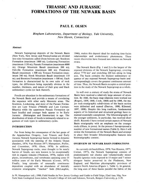
TRIASSIC AND JURASSIC FORMATIONS OF THE NEWARK BASIN<br />
Fig. 2 The Newark Basin.<br />
A. Geologic map showing distribution <strong>of</strong> <strong>formations</strong>,<br />
conglomeritic facies (irregular stipple), <strong>and</strong> major clusters<br />
<strong>of</strong> detrital cycles in Passaic Formation (parallel black lines)<br />
-- abbreviations <strong>of</strong> <strong>formations</strong> <strong>and</strong> diabase bodies as<br />
follows: 9, Boonton Formation; C, C<strong>of</strong>fman Hill Diabase;<br />
Cd, Cushetunk Mountain Diabase; F, Feltville Formation;<br />
H, Hook Mountain Basalt; Hd, Haycock Mountain<br />
Diabase; Jb, Jacksonwald Basalt; L, Lockatong<br />
Formation; 0, Orange Mountain Basalt; P, Passaic<br />
Formation; Pb, Preakness Basalt; Pd, Palisade Diabase;<br />
Pk, Perkasie Member <strong>of</strong> Passaic Formation; Rd, Rocky<br />
Hill Diabase; S, Stockton Formation; Sc, carbonate Facies<br />
<strong>of</strong> Stockton Formation; Sd, Sourl<strong>and</strong> Mountain Diabase;<br />
T, Towaco Formation.<br />
B. Structural features <strong>of</strong> <strong>the</strong> Newark Basin. Faults are all<br />
drawn as normal with dots on <strong>the</strong> down-thrown side;<br />
portions <strong>of</strong> <strong>basin</strong> margin not mapped as faults should be<br />
regarded as onlaps. While all <strong>the</strong> faults are mapped here as<br />
Appalachian Orogene (Rodgers, 1970; Van Houten,<br />
1977). The rocks <strong>of</strong> <strong>the</strong>se <strong>basin</strong>s present a relatively<br />
unified lithology <strong>and</strong> structure <strong>and</strong> unconformably<br />
overlie (or intrude) Precambrian <strong>and</strong> Palaeozoic rocks.<br />
They are in turn overlain by post-Jurassic rocks <strong>of</strong> <strong>the</strong><br />
Coastal Plain, Pleistocene deposits or Recent alluvium<br />
<strong>and</strong> soils. In addition, early Mesozoic red clastics,<br />
basaltic volcanics, <strong>and</strong> evaporites at <strong>the</strong> base <strong>of</strong> some se-<br />
quences on <strong>the</strong> continental shelf <strong>and</strong> also at least 12<br />
units recognized beneath <strong>the</strong> Atlantic Coastal Plain pro-<br />
bably should be grouped in <strong>the</strong> Newark Supergroup<br />
(Figure 1).<br />
Precambrian <strong>and</strong> early Paleaozoic rocks <strong>of</strong> <strong>the</strong><br />
southwestern prongs <strong>of</strong> <strong>the</strong> New Engl<strong>and</strong> Upl<strong>and</strong><br />
normal, it is clear many, if not all <strong>of</strong> <strong>the</strong>m, have some<br />
component <strong>of</strong> strike slip, although <strong>the</strong> significance <strong>of</strong> this<br />
component is unclear. Symbols for <strong>the</strong> names <strong>of</strong> structural<br />
features used in this paper are as follows: A, Montgomery-<br />
Chester fault block; B, Bucks-Hunterdon fault block; C,<br />
Sourl<strong>and</strong> Mountain fault block; D, Watchung syncline; E,<br />
New Germantown syncline; F, Flemington syncline; G,<br />
S<strong>and</strong> Brook syncline; H, Jacksonwald syncline; I, Ramapo<br />
fault; J, braided connectoin between Ramapo <strong>and</strong><br />
Hopewell faults; K, Flemington fault; L, Chalfont fault;<br />
M, Hopewell fault.<br />
Data for A <strong>and</strong> B from Kimmel, 1897; Lewis <strong>and</strong> Kimmel,<br />
1910-1912; Darton, 1890, 1902; Darton, et a]., 1908;<br />
Glaeser, 1963; S<strong>and</strong>ers, 1962; Van Houten, 1969;<br />
McLaughlin, 1941, 1943, 1944, 1945, 1946a, 1946b;<br />
Bascom, et at., 1909; Willard, et al., 1959; Faille, 1963;<br />
Manspeizer, pers. comm.; Olsen, in press, <strong>and</strong> personal<br />
observation.<br />
border <strong>the</strong> Newark Basin along its nor<strong>the</strong>ast <strong>and</strong> northwest<br />
margins (Figure 2). The sou<strong>the</strong>astern <strong>and</strong><br />
southwestern portions <strong>of</strong> <strong>the</strong> Newark Basin overlie <strong>and</strong><br />
are bordered by Palaeozoic <strong>and</strong> Precambrian rocks <strong>of</strong><br />
<strong>the</strong> Blue Ridge <strong>and</strong> Piedmont Provinces. Newark Basin<br />
sediments rest with a pr<strong>of</strong>ound unconformity on basement<br />
rocks <strong>and</strong> mostly dip 5 Â - 25' to <strong>the</strong> northwest.<br />
The entire stratigraphic column reaches a cumulative<br />
trigonometrically calculated thickness <strong>of</strong> over 10,300 m<br />
(<strong>the</strong> sum <strong>of</strong> <strong>the</strong> maximum thicknesses <strong>of</strong> all <strong>the</strong> <strong>formations</strong>),<br />
although <strong>the</strong> total thickness <strong>of</strong> sediments actually<br />
deposited at any one spot was probably much less. Red<br />
clastics are <strong>the</strong> dominant sediments; intrusive <strong>and</strong> extrusive<br />
tholeiites are <strong>the</strong> dominant igneous rocks. The<br />
oldest sediments are probably middle Carnian (early
5 FIELD STUDIES OF NEW JERSEY GEOLOGY AND GUIDE TO FIELD TRIPS<br />
Table 1<br />
Key to<br />
Figure 11 Rock-stratigraphic term I Bas in name<br />
1<br />
2<br />
3<br />
4<br />
6<br />
7 1<br />
I<br />
none<br />
Chatham Group<br />
undifferentiated<br />
undifferentiated<br />
undifferentiated<br />
Dan River Group<br />
Tuckahoe <strong>and</strong><br />
Chesterfield Groups<br />
9 undifferentiated<br />
10<br />
11<br />
12 1<br />
13<br />
14 1<br />
15 1<br />
none<br />
none<br />
Fundy<br />
none<br />
none<br />
none<br />
Group<br />
Deep River Basin<br />
Davie County Basin<br />
Farmville Basin<br />
4 small <strong>basin</strong>s south<br />
<strong>of</strong> Farmville Basin<br />
Dan River <strong>and</strong> Danville<br />
Bas ins<br />
Richmond Basin <strong>and</strong><br />
subsidiary <strong>basin</strong>s<br />
Culpeper Basin<br />
Taylorsville Basin<br />
Scottsville Basin <strong>and</strong><br />
2 subsidiary <strong>basin</strong>s<br />
Gettysburg Basin<br />
Newark Basin<br />
Pomperaug Bas in<br />
Hartford Basin <strong>and</strong><br />
subsidiary Cherry<br />
Brook Basin<br />
Deerfield Basin<br />
Fundy Basin<br />
Chedabucto Format ion Chedabucto Basin<br />
(=Eurydice Format ion?) (=Orpheus Basin?)<br />
Age range<br />
Carnian- ?Nor ian<br />
(Late Triassic)<br />
Late Triassic<br />
'Carnian (Late<br />
Triassic)<br />
'PCarnian (Late<br />
Triassic)<br />
Carnian- ';Norian<br />
(Late Triassic)<br />
Carnian (Late<br />
Triassic)<br />
Norian- PSinemurian<br />
(Late Triassic-<br />
Early Jurassic)<br />
Carnian (Late<br />
Triassic)<br />
?Late Triassic-<br />
Early Jurassic<br />
Carnian-Het tangian<br />
(Late Triassic-<br />
Early Jurassic)<br />
Carnian .Sinemurian<br />
(Late Triassic-<br />
Early Jurassic)<br />
?Late Triassic-<br />
Early Jurassic<br />
Norian-?Bajocian<br />
(Late Triassic-<br />
?Middle Jurassic)<br />
?Norian- PToarcian<br />
(Late Triassic-<br />
Early Jurassic)<br />
?Middle Triassic-<br />
Early Jurassic<br />
?Late Triassic-<br />
Early Jurassic
TRIASSIC AND JURASSIC FORMATIONS OF THE NEWARK BASIN<br />
Kummel, 1897;<br />
Lyman, 1895 Darton, 1890<br />
American New Red S<strong>and</strong>stone<br />
Pottstown Shales<br />
Perkasie Shales<br />
Lansdale Shales<br />
Gwynedd Shales<br />
Norristown Shales<br />
Newark System<br />
(<strong>of</strong> Newark Basin)<br />
Brunswick Formation<br />
'3rd" Watchung Basalt<br />
Brunswick Formation<br />
"2nd" Watchung Basalt<br />
Brunswick Formation<br />
'1st" Watchung Basalt<br />
Brunswick Formation<br />
Lockatong Formation<br />
Stockton Formation<br />
Late Triassic) in age while <strong>the</strong> youngest appear to be<br />
Sinemurian (middle Early Jurassic) (Cornet, 1977;<br />
Olsen, McCune, <strong>and</strong> Thomson, in press). Cretaceous<br />
<strong>and</strong> younger Coastal Plain deposits overlap Newark<br />
beds with an angular unconformity along <strong>the</strong> <strong>basin</strong>'s<br />
eastern edge. The nor<strong>the</strong>rn quarter <strong>of</strong> <strong>the</strong> <strong>basin</strong> is<br />
mantled by Pleistocene <strong>and</strong> recent deposits.<br />
The first lithostratigraphic terms for <strong>the</strong> sedimentary<br />
<strong>formations</strong> <strong>of</strong> <strong>the</strong> Newark Basin were introduced by<br />
Lyman in 1895 (Table 2). Although he clearly demar-<br />
cated <strong>the</strong> units in <strong>the</strong>ir type areas (sou<strong>the</strong>astern Penn-<br />
sylvania), mapped <strong>and</strong> briefly described <strong>the</strong>m, his terms<br />
never gained wide acceptance. In 1897, Kiimmel in-<br />
troduced his own nomenclature for equivalent rocks in<br />
New Jersey (Table 2). Since <strong>the</strong>ir introduction, Klim-<br />
mel's terms have been widely used. While <strong>the</strong> rule <strong>of</strong><br />
priority applies to stratigraphic names, no practical pur-<br />
pose is served by resurrecting those <strong>of</strong> Lyman. This is in<br />
accordance with Code <strong>of</strong> Stratigraphic Nomenclature,<br />
1961 (hereafter C. N. S.), article 1 lb, <strong>and</strong> with <strong>the</strong> Inter-<br />
national Stratigraphic Guide, 1976 (hereafter I. S. G.),<br />
I chapter 3e.<br />
Kiimmel (1897) divided <strong>the</strong> Newark Basin sequence<br />
into three <strong>formations</strong>: Stockton, Lockatong, <strong>and</strong><br />
Brunswick. The Stockton Formation (maximum<br />
thickness ca. 1800 m) consists <strong>of</strong> thick beds <strong>of</strong> buff or<br />
cream colored conglomerate <strong>and</strong> s<strong>and</strong>stone <strong>and</strong> red<br />
siltstone <strong>and</strong> s<strong>and</strong>stone forming <strong>the</strong> basal formation <strong>of</strong><br />
<strong>the</strong> Newark Basin. Throughout <strong>the</strong> exposed central por-<br />
tion <strong>of</strong> <strong>the</strong> Newark Basin, <strong>the</strong> Stockton Formation is<br />
Table 2<br />
Baird <strong>and</strong> Take,<br />
1959; Baird, 1964; (Olsen, in press)<br />
Colbert, 1965 This Article<br />
Newark System<br />
(<strong>of</strong> Newark Basin)<br />
Newark Supergroup<br />
(<strong>of</strong> Newark Basin)<br />
Boonton <strong>and</strong> Whitehall Boonton Formation<br />
Beds<br />
Hook Mountain Basalt Hook Mountain Basalt<br />
Brunswick Formation Towaco Formation<br />
"2nd" Watchung Basalt Preakness Basalt<br />
Brunswick Formation Feltville Formation<br />
"1st" Watchung Basalt Orange Mountain Basalt<br />
Brunswick Formation Passaic Formation<br />
Lockatong Formation Lockatong Formation<br />
Stockton Formation Stockton Formation<br />
overlain by <strong>the</strong> Lockatong Formation (maximum<br />
thickness 1150 m) which is made up <strong>of</strong> beds <strong>of</strong> gray <strong>and</strong><br />
black siltstone. These siltstones are arranged, as Van<br />
Houten (1969) later showed, in distinctive sedimentary<br />
cycles. The youngest formation KUmmel recognized is<br />
<strong>the</strong> Brunswick. Throughout <strong>the</strong> Newark Basin, <strong>the</strong><br />
lower half <strong>of</strong> this formation consists mostly <strong>of</strong> red<br />
siltstone, s<strong>and</strong>stone, <strong>and</strong> conglomerate with clusters <strong>of</strong><br />
laterally persistent cycles <strong>of</strong> gray <strong>and</strong> black siltstone<br />
similar to that in <strong>the</strong> Lockatong Formation (Kiimmel,<br />
1897,1898; McLaughlin, 1943; Van Houten, 1969). The<br />
upper Brunswick, on <strong>the</strong> o<strong>the</strong>r h<strong>and</strong>, is made up <strong>of</strong><br />
three major, multiple-flow, basalt sheets (units Darton<br />
in 1890 called <strong>the</strong> Watchung Basalts), two major in-<br />
terbedded sedimentary units, <strong>and</strong> a thick overlying<br />
sedimentary unit. The latter sedimentary sequences have<br />
escaped even preliminary lithologic description.<br />
Field work by myself <strong>and</strong> o<strong>the</strong>rs (Olsen, in press) has<br />
shown that Kummel's Brunswick Formation consists <strong>of</strong><br />
a heterogeneous mix <strong>of</strong> major, mappable units <strong>of</strong> differ-<br />
ing <strong>and</strong> distinctive lithology, each as distinct <strong>and</strong><br />
perhaps originally as widespread as <strong>the</strong> Stockton or<br />
Lockatong; "Watchung Basalt" <strong>and</strong> <strong>the</strong> interbedded<br />
<strong>and</strong> overlying sedimentary beds are lithologically<br />
distinct from <strong>the</strong> stratigraphically older beds. In addi-<br />
tion, Kummel's upper Brunswick is Early Jurassic,<br />
ra<strong>the</strong>r than Late Triassic as most authors have assumed<br />
(Cornet, Traverse <strong>and</strong> McDonald, 1973; Cornet <strong>and</strong><br />
Traverse, 1975; Cornet, 1977; Olsen <strong>and</strong> Galton, 1977;<br />
Olsen, McCune, <strong>and</strong> Thomson, in press). It now seems<br />
that <strong>the</strong>se Jurassic rocks are in many ways different
7 FIELD STUDIES OF NEW JERSEY GEOLOGY AND GUIDE TO FIELD TRIPS<br />
from <strong>the</strong> Late Triassic lower Brunswick Formation,<br />
Lockatong, or Stockton <strong>formations</strong>.<br />
I have proposed elsewhere (Olsen, in press) that <strong>the</strong><br />
terms Brunswick Formation (Kiimmel, 1897) <strong>and</strong> Wat-<br />
chung Basalts (Darton, 1890) be dropped <strong>and</strong> <strong>the</strong>ir com-<br />
ponents subdivided to form seven new <strong>formations</strong>.<br />
Despite <strong>the</strong> wide (although inconsistent) use <strong>of</strong> those<br />
terms over <strong>the</strong> years, it is inappropriate to conserve<br />
<strong>the</strong>m for <strong>the</strong> following reasons:<br />
1. The division <strong>of</strong> <strong>the</strong> Brunswick Formation <strong>of</strong> Kum-<br />
me1 into four sedimentary <strong>formations</strong> constitutes a ma-<br />
jor redefinition <strong>of</strong> <strong>the</strong> unit. C.S.N. article 14b recom-<br />
mends that "When a unit is divided into two or more <strong>of</strong><br />
<strong>the</strong> same rank as <strong>the</strong> original, <strong>the</strong> original name should<br />
not be employed for any <strong>of</strong> <strong>the</strong> revisions." Thus, while<br />
it could be argued that <strong>the</strong> term Brunswick Formation<br />
should be retained for <strong>the</strong> pre-basalt sediments <strong>of</strong> <strong>the</strong><br />
Newark Basin, such use could be a source <strong>of</strong> confusion,<br />
<strong>and</strong> it seems better to establish a new term for <strong>the</strong> pre-<br />
basalt, post-Lockatong beds.<br />
2. Darton's Watchung Basalt has been traditionally<br />
recognized as a single formation embracing <strong>the</strong> three<br />
major multiple flow units interbedded in Kiimmel's<br />
upper Brunswick Formation (see, for example,<br />
Wilmarth, 1938, p. 896; Faust, 1975, 1978; Van<br />
Houten, 1969, p. 327). Since both <strong>the</strong> C.S.N. (article<br />
lOh) <strong>and</strong> <strong>the</strong> I.S.G. (chapter 5f, 1c) state that repetition<br />
<strong>of</strong> geographic names in <strong>formations</strong> is considered<br />
informal nomenclature, it is appropriate to drop <strong>the</strong><br />
formal use <strong>of</strong> <strong>the</strong> term Watchung Basalt <strong>and</strong> recognize<br />
three basalt <strong>formations</strong> with individual names (Table 2).<br />
The new formational names I have proposed to<br />
replace Kummel's <strong>and</strong> Darton's <strong>formations</strong> are (from<br />
<strong>the</strong> bottom up): Passaic Formation, Orange Mountain<br />
Basalt, Feltville Formation, Preakness Basalt, Towaco<br />
Formation, Hook Mountain Basalt, <strong>and</strong> Boonton<br />
Formation. These new divisions <strong>of</strong> <strong>the</strong> Newark Basin<br />
section are similar in scale to Emerson's (1898) <strong>and</strong><br />
Lehman's (1959) widely used divisions <strong>of</strong> <strong>the</strong> Hartford<br />
Basin <strong>and</strong> Klein's (1962) divisions <strong>of</strong> <strong>the</strong>Fundy Group,<br />
<strong>and</strong> are in accordance with <strong>the</strong> letter <strong>and</strong> intent <strong>of</strong> <strong>the</strong><br />
C.S.N. <strong>and</strong> I.S.G. In this way, formal names are given<br />
to beds critical to <strong>the</strong> overall pattern <strong>of</strong> Newark Basin<br />
historical geology.<br />
A NOTE ON THE CALCULATION OF<br />
STRATIGRAPHIC THICKNESS<br />
The arguments which center on <strong>the</strong> accuracy <strong>of</strong><br />
trigonometrically computed stratigraphic thicknesses <strong>of</strong><br />
Newark Basin sections (Rogers, 1840, 1865; Kummel,<br />
1898; Faill, 1973; Faust, 1975; S<strong>and</strong>ers, MS) concern<br />
two components. First, deposition along <strong>the</strong> stepfaulted<br />
northwest margin decreases <strong>the</strong> real thickness <strong>of</strong> beds<br />
preserved at any one place. This is a major concern, but<br />
<strong>the</strong> problem can beat least partially resolved by careful<br />
analysis <strong>of</strong> existing outcrops <strong>and</strong> geophysical data (see<br />
Faill, 1973, for a review <strong>and</strong> Dunleavy, 1975, <strong>and</strong> Olsen,<br />
in press, for particulars) (see Figure 5). Second, <strong>the</strong>re<br />
are a large number <strong>of</strong> hidden strike faults with large dip-<br />
slip components. This problem has no clear quantitative<br />
solution in some important areas. In parts <strong>of</strong> <strong>the</strong><br />
Newark Basin, such as <strong>the</strong> entire nor<strong>the</strong>rn third <strong>of</strong> <strong>the</strong><br />
<strong>basin</strong>, this is a substantial problem, as <strong>the</strong> following<br />
examples show (Figure 2).<br />
1. A suite <strong>of</strong> faults has long been known to <strong>of</strong>fset <strong>the</strong><br />
nor<strong>the</strong>rn segments <strong>of</strong> <strong>the</strong> Watchung ridges (Kummel,<br />
1897; Darton, et al., 1908; Olsen, in press). These series<br />
cut <strong>the</strong> type sections <strong>of</strong> both <strong>the</strong> Orange Mountain<br />
Basalt <strong>and</strong> <strong>the</strong> Preakness Basalt. 2. Ano<strong>the</strong>r suite <strong>of</strong><br />
faults cuts <strong>the</strong> Palisades ridge, especially in <strong>the</strong> area <strong>of</strong><br />
Weehawken <strong>and</strong> Edgewater, New Jersey (Kiimmel,<br />
1898; Van Houten, 1969; Olsen, in press). 3. Faults<br />
duplicate 30 % <strong>of</strong> <strong>the</strong> exposed Lockatong Formation at<br />
Gwynned, Pennsylvania (Watson, 1958). Many o<strong>the</strong>r<br />
examples are know (Willard, et al., 1959; Rima,<br />
Meisler, <strong>and</strong> Longwill, 1962).<br />
Most <strong>of</strong> <strong>the</strong>se faults are visible because <strong>the</strong>y cut ridges<br />
with topographically expressed <strong>of</strong>fsets; in areas <strong>of</strong> low<br />
topography, <strong>the</strong>y do not show up. In certain areas, such<br />
as <strong>the</strong> Passaic Formation type section (Figure 6), <strong>the</strong><br />
distribution <strong>of</strong> such faults is essentially unknown.<br />
Those faults presently mapped which cut <strong>the</strong> Watchung<br />
ridges must continue <strong>and</strong> cut <strong>the</strong> Passaic<br />
Formation,though <strong>the</strong>y may eventually die out. Thus,<br />
<strong>the</strong> trigonometrically computed thickness for <strong>the</strong><br />
Passaic Formation in <strong>the</strong> nor<strong>the</strong>rn third <strong>of</strong> <strong>the</strong> Newark<br />
Basin is certainly an overestimation.<br />
In contrast, <strong>the</strong> field relationships <strong>of</strong> mapped gray<br />
<strong>and</strong> black siltstone <strong>and</strong> conglomerate beds in <strong>the</strong> Bucks-<br />
Hunterdon fault block (see Figure 2) show that <strong>the</strong>se<br />
small strike faults are absent over broad areas. In <strong>the</strong>se<br />
areas <strong>the</strong> trigonometrically computed thicknesses have<br />
been confirmed by some deep well records (Lesley,<br />
1891; McLaughlin, 1943). This inconsistency over parts<br />
<strong>of</strong> <strong>the</strong> Newark Basin demonstrates that <strong>the</strong>re can be no<br />
single constant to correct for "hidden faults." Ra<strong>the</strong>r,<br />
if a correction is attempted (as in Figure 6) it must be<br />
based on extrapolation <strong>of</strong> <strong>the</strong> local fault patterns. For<br />
thin units, such as <strong>the</strong> nor<strong>the</strong>rn outcrops <strong>of</strong> <strong>the</strong><br />
Lockatong or <strong>the</strong> basalt <strong>formations</strong>, <strong>the</strong>se small faults<br />
usually do not present much <strong>of</strong> a problem sincc<strong>the</strong>re are<br />
single outcrops covering much <strong>of</strong> each unit.<br />
As a general guide, I place most confidence in<br />
thickness determinations in <strong>the</strong> Bucks-Hunterdon Block<br />
<strong>and</strong> <strong>the</strong> least confidence in <strong>the</strong> calculated thicknesses at<br />
<strong>the</strong> nor<strong>the</strong>astern <strong>and</strong> southwestern portions <strong>of</strong> <strong>the</strong>
TRIASSIC AND JURASSIC FORMATIONS OF THE NEWARK BA SIN 8<br />
Newark Basin.<br />
STOCKTON FORMATION<br />
The Stockton Formation is <strong>the</strong> poorest known <strong>of</strong> all<br />
Newark Basin <strong>formations</strong>. It is also <strong>the</strong> oldest <strong>and</strong> most<br />
widespread deposit, forming <strong>the</strong> basal beds <strong>of</strong> <strong>the</strong><br />
Newark Basin section everywhere except along portions<br />
<strong>of</strong> <strong>the</strong> northwest border.The Stockton is thickest near<br />
<strong>the</strong> Bucks-Montgomery county line in <strong>the</strong> Bucks-<br />
Hunterdon fault block (Figure 2), where it reaches a<br />
calculated stratigraphic thickness <strong>of</strong> 1830 m (Willard, et<br />
al., 1959). Along its type section (Figure 3, Table 3)<br />
along <strong>the</strong> shores <strong>of</strong> <strong>the</strong> Delaware River near Stockton,<br />
New Jersey, <strong>the</strong> formation is 1500 m thick<br />
(McLaughlin, 1945). Measured from <strong>the</strong> base <strong>of</strong> <strong>the</strong><br />
lowest continuous black siltstone unit <strong>of</strong> <strong>the</strong> overlying<br />
Lockatong Formation, <strong>the</strong> Stockton thins in all direc-<br />
tions from this central area (Kiimmel, 1897). Towards<br />
<strong>the</strong> south at Norristown, Pennsylvania it is 1221 m <strong>and</strong><br />
at Phoenixville, Pennsylvania it is 700 m; to <strong>the</strong> north<br />
near Clinton, New Jersey it is 1350 m; to <strong>the</strong> east near<br />
Princeton, New Jersey it is 920 m; <strong>and</strong> to <strong>the</strong> nor<strong>the</strong>ast<br />
at Hoboken <strong>and</strong> Weehawken, New Jersey it is less than<br />
250 m. The predeformational shape <strong>of</strong> <strong>the</strong> Stockton<br />
Formation lithosome is thus an asymmetrical lens with<br />
<strong>the</strong> thickest portion near <strong>the</strong> center <strong>of</strong> <strong>the</strong> Bucks-<br />
Hunterdon fault block (see Figure 4). McLaughlin (in<br />
Willard, et al., 1959) presents evidence that <strong>the</strong><br />
Stockton Formation in <strong>the</strong> sou<strong>the</strong>rn Newark Basin thins<br />
by a progressive onlap <strong>of</strong> younger Stockton beds onto<br />
basement.<br />
Stockton lithology is diverse. The dominant sediment<br />
types are gray <strong>and</strong> buff colored arkose <strong>and</strong> arkosic con-<br />
glomerate, <strong>and</strong> red siltstone <strong>and</strong> arkosic s<strong>and</strong>stone. In<br />
broad view, <strong>the</strong> Stockton Formation fines upward with<br />
<strong>the</strong> coarsest sediments near <strong>the</strong> base. As noted by<br />
McLaughlin (In Willard, et al., 1959) <strong>the</strong> Stockton<br />
coarsens in <strong>the</strong> same directions it thins; thus con-<br />
glomerate bodies <strong>and</strong> coarse arkose are found high in<br />
<strong>the</strong> section along <strong>the</strong> eastern edge <strong>of</strong> <strong>the</strong> <strong>basin</strong>.<br />
The belt <strong>of</strong> Stockton Formation which runs through<br />
<strong>the</strong> Bucks-Hunterdon fault block <strong>and</strong> through <strong>the</strong><br />
Montgomery-Chester fault block (Figure 2) has been<br />
divided into members by McLaughlin (In Willard et al.,<br />
1959) <strong>and</strong> by Rima, Meisler <strong>and</strong> Longwill (1962),<br />
primarily on <strong>the</strong> basis <strong>of</strong> texture (Table 3).They did not<br />
attempt to extend <strong>the</strong>se member names into o<strong>the</strong>r parts<br />
<strong>of</strong> <strong>the</strong> Newark Basin. Upper Stockton fissile red s<strong>and</strong>-<br />
stone <strong>and</strong> siltstone pass upwards into hard non-fissile<br />
red siltstones (argillite) in <strong>the</strong> Bucks-Hunterdon belt.<br />
These siltstones have been grouped with <strong>the</strong> overlying<br />
Lockatong Formation by a number <strong>of</strong> authors<br />
(McLaughlin, 1945; McLaughlin, In Willard et al.,<br />
1959; Van Houten, 1969). I believe <strong>the</strong> Stockton-<br />
Lockatong boundary should be defined at <strong>the</strong> base <strong>of</strong><br />
<strong>the</strong> lowest continuous black siltstone bed. This is in ac-<br />
cord with Kiimmel's own definition which does not<br />
seem to include 30 m <strong>of</strong> red beds at <strong>the</strong> base <strong>of</strong> <strong>the</strong><br />
Lockatong, although I think his definition is somewhat<br />
vague. I group <strong>the</strong>se red siltstones with <strong>the</strong> Stockton.<br />
While <strong>the</strong> predominant facies trend is clearly upward<br />
fining, important beds <strong>of</strong> different lithology occur<br />
throughout. Basal Stockton beds, where <strong>the</strong>y are expos-<br />
ed, rest on a locally .irregular surface. Where basal<br />
Stockton beds rest on Cambro-Ordovician limestones,<br />
red matrix limestone breccia <strong>and</strong> red siltstone fill ap-<br />
parent solution cavities. Elsewhere, <strong>the</strong>re are basal red-<br />
matrix conglomerate <strong>and</strong> breccia composed <strong>of</strong> underly-<br />
ing basement rocks (Olsen, in press). The main masses<br />
<strong>of</strong> Stockton Formation conglomerate in <strong>the</strong> central part<br />
<strong>of</strong> <strong>the</strong> <strong>basin</strong>, however, are definitely not basal <strong>and</strong> rest<br />
some 100 m above <strong>the</strong> base <strong>of</strong> <strong>the</strong> formation. These con-<br />
glomerates are gray <strong>and</strong> buff, but are never red (Rima,<br />
Miesler, <strong>and</strong> Longwill, 1962; McLaughlin in Willard, et<br />
al. 1959).<br />
Red siltstones <strong>of</strong> <strong>the</strong> Stockton Formation are<br />
characteristically intensively bioturbated by roots <strong>and</strong><br />
burrows, notably <strong>the</strong> arthropod burrow Scoyenia (see<br />
Olsen, 1977). Purple <strong>and</strong> mauve siltstone beds with a<br />
markedly disrupted fabric occur near <strong>the</strong> middle <strong>and</strong><br />
top <strong>of</strong> <strong>the</strong> formation. These beds are usually densely<br />
penetrated by roots, but rarely burrowed by Scoyenia.<br />
Beds <strong>of</strong> greenish-gray <strong>and</strong> brown carbonate-rich pellets<br />
occur throughout <strong>the</strong> formation. These are <strong>of</strong>ten<br />
associated with bases <strong>of</strong> buff arkose beds. Well-bedded<br />
gray <strong>and</strong> gray-green siltstone beds are present locally in<br />
<strong>the</strong> upper Stockton, <strong>and</strong> <strong>the</strong>se beds are <strong>the</strong> source <strong>of</strong><br />
most <strong>of</strong> <strong>the</strong> Stockton fossils found so far. How <strong>the</strong>se<br />
units, which are unusual compared to <strong>the</strong> bulk <strong>of</strong> <strong>the</strong><br />
Stockton sequence, fit in <strong>the</strong> overall facies pattern re-<br />
mains obscure.<br />
LOCKATONG FORMATION<br />
The beds <strong>of</strong> <strong>the</strong> Lockatong Formation rest confor-<br />
mably on <strong>the</strong> Stockton Formation over most <strong>of</strong> <strong>the</strong><br />
Newark Basin. The Lockatong is composed primarily <strong>of</strong><br />
gray <strong>and</strong> black siltstones arranged, as shown by Van<br />
Houten (1962, 1964, 1965, 1969, 1977), in sedimentary<br />
cycles. In <strong>the</strong> Bucks-Hunterdon fault block, near <strong>the</strong><br />
Lockatong's type section along Lockatong Creek, <strong>the</strong><br />
formation reaches its maximum thickness <strong>of</strong> 1150 m<br />
(Figure 2, Table 4). The formation thins in all direc-<br />
tions away from this central area, passing into Passaic<br />
<strong>and</strong> Stockton <strong>formations</strong> along exposed edges <strong>of</strong> <strong>the</strong><br />
Newark Basin.<br />
Van Houten (1962, 1964a,b, 1965, 1969, 1977)<br />
recognizes two end-members to <strong>the</strong> range <strong>of</strong> short cycle
9 FIELD STUDIES OF NEW JERSEY GEOLOGY AND GUIDE TO FIELD TRIPS<br />
Fig. 3 Geographic map <strong>of</strong> Newark Basin showing locations <strong>of</strong><br />
type sections <strong>of</strong> <strong>formations</strong>: a, type section <strong>of</strong> Passaic<br />
Formation; b, type section <strong>of</strong> Orange Mountain Basalt; c, I<br />
type section <strong>of</strong> Feltville Formation; d, type section <strong>of</strong><br />
Preakness Mountain Basalt; e, type section <strong>of</strong> Towaco<br />
Formation in Rosel<strong>and</strong>, New Jersey; f, type section <strong>of</strong><br />
Hook Mountain Basalt in Pine Brook, New Jersey; g, type<br />
section <strong>of</strong> Boonton Formation, Boonton, New Jersey; h,<br />
type section <strong>of</strong> Lockatong Formation along both shores <strong>of</strong><br />
<strong>the</strong> Delaware River north <strong>of</strong> Stockton, New Jersey; i, type<br />
section <strong>of</strong> Stockton Formation near Stockton, New Jersey<br />
just south <strong>of</strong> <strong>the</strong> type section <strong>of</strong> <strong>the</strong> Lockatong.<br />
types present in <strong>the</strong> Lockatong; he terms <strong>the</strong>se detrital<br />
<strong>and</strong> chemical. In <strong>the</strong> Delaware River section <strong>of</strong> <strong>the</strong> for-<br />
mation <strong>the</strong> detrital cycles are an average <strong>of</strong> 5.2 m thick<br />
<strong>and</strong> consist <strong>of</strong> a lower platy black calcareous siltstone<br />
succeeded upwards by beds <strong>of</strong> disrupted dark gray,<br />
calcareous siltstone, ripple-bedded siltstone, <strong>and</strong> fine<br />
s<strong>and</strong>stone. In <strong>the</strong> same area, chemical cycles average 3.2<br />
m thick. Their lower beds consist <strong>of</strong> platy black <strong>and</strong><br />
dark gray dolomitic siltstone, broken by shrinkage<br />
cracks, <strong>and</strong> containing lenses <strong>of</strong> pyritic limestone. The<br />
upper beds are massive gray or red analcime- <strong>and</strong><br />
carbonate-rich siltstone, intensively <strong>and</strong> minutely<br />
disrupted. The massive beds <strong>of</strong>ten contain pseudo-<br />
morphs after analcime <strong>and</strong> glauberite.<br />
Detrital <strong>and</strong> chemical cycles are not distributed ran-<br />
domly through <strong>the</strong> Lockatong. In vertical section, in <strong>the</strong><br />
central Newark Basin, <strong>the</strong> two cycle types occur in<br />
clusters; <strong>the</strong> center <strong>of</strong> each detrital cycle cluster is about<br />
107 m from <strong>the</strong> next. Detrital cycle clusters are<br />
separated by clusters <strong>of</strong> chemical cycles. Again, in ver-<br />
tical section, <strong>the</strong>re are more detrital cycles in <strong>the</strong> lower<br />
than in <strong>the</strong> upper Lockatong. Evidence ga<strong>the</strong>red so far<br />
(Olsen, this Fieldbook) indicates that individual detrital<br />
cycles can be traced for over 20 km. Judging from <strong>the</strong><br />
outcrop pattern <strong>of</strong> detrital cycle clusters in <strong>the</strong> upper<br />
Lockatong <strong>and</strong> lower Passaic Formation, it seems likely<br />
that individual detrital cycles can be traced <strong>basin</strong>-wide.<br />
Chemical cycles, on <strong>the</strong> o<strong>the</strong>r h<strong>and</strong>, are predominantly<br />
restricted to <strong>the</strong> central 97 km <strong>of</strong> <strong>the</strong> Newark Basin,<br />
passing laterally into beds indistinguishable from <strong>the</strong><br />
Stockton <strong>and</strong> Passaic <strong>formations</strong>. At <strong>the</strong> southwestern<br />
end <strong>of</strong> <strong>the</strong> Newark Basin at Phoenixville, Pennsylvania,<br />
<strong>the</strong> Lockatong is 350 m thick; <strong>the</strong> formation consists <strong>of</strong><br />
clusters <strong>of</strong> detrital cycles separated by red siltstone <strong>and</strong><br />
some beds <strong>of</strong> gray s<strong>and</strong>stone. At <strong>the</strong> nor<strong>the</strong>astern end <strong>of</strong>
TRIASSIC AND JURASSIC FORMATIONS OF THE NEWARK BASIN<br />
Fig. 4 A - E, type section <strong>of</strong> Passaic Formation (Table 5 for<br />
description); F, diagram showing positions <strong>of</strong> sections A - E<br />
in Passaic Formation.<br />
<strong>the</strong> Newark Basin at weehawken, <strong>the</strong> Lockatong is 150<br />
m thick <strong>and</strong> consists <strong>of</strong> detrital cycle clusters separated<br />
by beds <strong>of</strong> buff arkosic s<strong>and</strong>stone. The large number <strong>of</strong><br />
detrital cycles prevalent in <strong>the</strong> lower Lockatong in <strong>the</strong><br />
central Newark Basin strongly suggests that <strong>the</strong><br />
Lockatong outside <strong>of</strong> its thickest central portion com-<br />
prises only <strong>the</strong> lower 500 m <strong>of</strong> <strong>the</strong> Lockatong or less<br />
(not including <strong>the</strong> lower 30 m <strong>of</strong> red siltstone grouped<br />
here in <strong>the</strong> Stockton).<br />
The thickness <strong>of</strong> <strong>the</strong> Lockatong decreases away from<br />
<strong>the</strong> central Newark Basin not only by replacement <strong>of</strong> its<br />
upper beds by Passaic Formation but also by <strong>the</strong> thin-<br />
ning <strong>of</strong> individual detrital cycles. While <strong>the</strong> mean<br />
detrital cycle thickness is 5.2 m along <strong>the</strong> Delaware<br />
River, for example, it is 1.5 m along <strong>the</strong> Hudson River<br />
(see Olsen, this Fieldbook).<br />
Beds along strike from <strong>the</strong> lower Lockatong at <strong>the</strong><br />
nor<strong>the</strong>astern, sou<strong>the</strong>astern, <strong>and</strong> northwestern edges <strong>of</strong><br />
<strong>the</strong> Newark Basin are indistinguishable from <strong>the</strong><br />
Stockton Formation <strong>and</strong> are thus mapped (Figure 2).<br />
PASSAIC FORMATION<br />
The name Passaic Formation has recently been ap-<br />
plied (Olsen, in press) to <strong>the</strong> predominantly red<br />
siltstones, s<strong>and</strong>stones, <strong>and</strong> conglomerate which confor-<br />
mably overlie <strong>the</strong> Lockatong Formation <strong>and</strong> which<br />
underlie <strong>the</strong> Orange Mountain <strong>and</strong> Jacksonwald<br />
Basalts. It is equivalent to <strong>the</strong> pre-basalt portion <strong>of</strong><br />
Kiimmel's Brunswick Formation (Table 2). The type<br />
section consists <strong>of</strong> intermittent exposures <strong>of</strong> red clastics<br />
along Interstate Route 80 near Passaic, New Jersey<br />
(Figure 3 <strong>and</strong> 7).<br />
The Passaic Formation is <strong>the</strong> thickest coherent<br />
lithologic unit in <strong>the</strong> Newark Basin, reaching a max-<br />
imum calculated thickness <strong>of</strong> over 6000 m (Jacksopwald .<br />
Syncline - Figure 2). The formation outcrops<br />
throughout <strong>the</strong> Newark Basin, although its upper beds<br />
are preserved only in <strong>the</strong> Watchung syncline (Figure 2),<br />
in <strong>the</strong> smaller synclines preserved along <strong>the</strong> eastern side<br />
<strong>of</strong> <strong>the</strong> Flemington Fault, <strong>and</strong> in <strong>the</strong> Jacksonwald<br />
Syncline (Figure 2). In all o<strong>the</strong>r areas, <strong>the</strong> upper Passaic<br />
has been removed by post-Newark erosion.<br />
While in most areas <strong>the</strong> Passaic Formation rests conformably<br />
on Lockatong Formation or, where that is absent,<br />
Stockton Formation, in several areas on <strong>the</strong><br />
western margin <strong>of</strong> <strong>the</strong> Newark Basin <strong>the</strong> Passaic directly<br />
overlaps <strong>the</strong> step-faulted basement without any intervening<br />
Stockton or Lockatong. In <strong>the</strong>se areas (Figure 2)<br />
<strong>the</strong> thickness <strong>of</strong> Passaic Formation present below <strong>the</strong><br />
Orange Mountain~asalt is comparatively slight.<br />
Facies patterns <strong>of</strong> <strong>the</strong> Passaic Formation are a<br />
modified continuation <strong>of</strong> those <strong>of</strong> <strong>the</strong> Lockatong, <strong>and</strong><br />
differ from all younger Newark Basin deposits. As in<br />
<strong>the</strong> Lockatong, periodically spaced clusters <strong>of</strong> detrital<br />
cycles occur through most <strong>of</strong> <strong>the</strong> thickness <strong>of</strong> Passaic<br />
Formation (Van Houten, 1969). The great majority <strong>of</strong><br />
<strong>the</strong>se non-red units, however, are not as laterally con-<br />
tinuous as those <strong>of</strong> <strong>the</strong> Lockatong, <strong>and</strong> as a general<br />
trend, it is clear that <strong>the</strong> number <strong>of</strong> cycles involved in<br />
<strong>the</strong>se clusters decrease in frequency upwards through<br />
<strong>the</strong> Passaic Formation (see ' Van Houten, this<br />
Fieldbook). The boundary between <strong>the</strong> Passaic Forma-<br />
tion <strong>and</strong> <strong>the</strong> Lockatong can be operationally defined<br />
(both horizontally <strong>and</strong> vertically) as where <strong>the</strong><br />
thicknesses <strong>of</strong> beds <strong>of</strong> red clastics dominate gray <strong>and</strong><br />
black. It follows from this definition that where gray<br />
<strong>and</strong> black detrital cycles do not occur, as in Rockl<strong>and</strong><br />
County, New York, <strong>the</strong> Passaic Formation rests directly<br />
on Stockton Formation.<br />
McLaughlin (1933, 1943, 1945, 1946, 1948) has suc-<br />
ceeded in mapping out <strong>the</strong> distribution <strong>of</strong> Passaic For-<br />
mation detrital cycle'clusters over <strong>the</strong> Bucks-Hunterdon<br />
Fault Block <strong>and</strong> part <strong>of</strong> <strong>the</strong> Montgomery-Chester fault
l\ FIELD STUDIES OF NEW JERSEY GEOLOGY AND GUIDE TO FIELD TRIPS<br />
Fig. 5 Approximate predeformational shapes <strong>of</strong> Stockton<br />
Formation (A) <strong>and</strong> Lockatong-Passaic Formation (B)<br />
sediment bodies.<br />
Fig. 6 Cross-section <strong>of</strong> <strong>the</strong> pre-Orange Mountain Basalt portion<br />
<strong>of</strong> <strong>the</strong> Newark Basin: A, position <strong>of</strong> section in Newark<br />
Basin; B, present cross section--note that <strong>the</strong> vertically<br />
ruled b<strong>and</strong> represents diabase <strong>and</strong> gabbro sills <strong>and</strong> plutons;<br />
C, reconstructed section with Passaic Formation-Orange<br />
Mountain Basalt contact as horizontal--note thinning to<br />
east <strong>and</strong> ramping to west.<br />
Abbreviations as follows: a, Haycock Mountain Pluton; b,<br />
C<strong>of</strong>fman Hill Pluton; c, Flemington syncline outlier <strong>of</strong><br />
0 30 km<br />
contour interval 200 m<br />
contour interval 500 m<br />
Orange Mountain Basalt <strong>and</strong> to <strong>the</strong> immediate left <strong>the</strong><br />
Flemington Fault; d, Hopewell Fault; e, Orange Mountain<br />
Basalt <strong>of</strong> Watchung syncline; L, Lockatong Formation; P<br />
Passaic Formation; P;. Perkasie Member <strong>of</strong> Passaic<br />
Formation; S, Stockton Formation. Note that <strong>the</strong><br />
trigonometrically calculated thickness <strong>of</strong> Passaic<br />
Formation east <strong>of</strong> <strong>the</strong> Watchung syncline has been reduced<br />
by 25% as a correction for dip slip faults.
TRIASSIC AND JURASSIC FORMATIONS OF THE NEWARK BASIN 12<br />
%!<br />
g 1<br />
- 8<br />
PASSAIC<br />
FM.<br />
Fig. 7 Type section <strong>of</strong> <strong>the</strong> Orange Mountain Basalt; exposure<br />
along Interstate Route 280 in East Orange, New Jersey.<br />
Traced from a composite <strong>of</strong> a continuous series <strong>of</strong><br />
photographs.<br />
block. A detailed physical stratigraphy has developed<br />
around <strong>the</strong>se mapped beds, each detrital cycle being<br />
designated by a letter (A,B,C, ...). The extension <strong>of</strong><br />
McLaughlin's units outside <strong>of</strong> <strong>the</strong> areas he mapped is a<br />
principal goal <strong>of</strong> ongoing field research (Figure 2). The<br />
highest <strong>of</strong> McLaughlin's mapped units (134 m above L<br />
<strong>and</strong> M) join with o<strong>the</strong>r cycles to <strong>the</strong> southwest to form a<br />
large body <strong>of</strong> black <strong>and</strong> gray siltstone called <strong>the</strong><br />
Perkasie Member (McLaughlin, 1946). Unlike <strong>the</strong><br />
Lockatong Formation, however, <strong>the</strong> thickest section <strong>of</strong><br />
<strong>the</strong> Perkasie Member is in <strong>the</strong> southwestern portion <strong>of</strong><br />
<strong>the</strong> Bucks-Hunterdon fault block. Due to repetition by<br />
<strong>the</strong> Hopewell, Flemington, <strong>and</strong> Chalfont Faults (Figure<br />
2) <strong>and</strong> changes in strike along folds, <strong>the</strong> broader aspects<br />
<strong>of</strong> <strong>the</strong> three dimensional relationships <strong>of</strong> most Passaic<br />
dark clastic units can be observed. Looking over <strong>the</strong><br />
bulk <strong>of</strong> <strong>the</strong> Passaic Formation (Figure 2), <strong>the</strong>re is no<br />
evidence that <strong>the</strong> rest <strong>of</strong> <strong>the</strong> detrital cycle clusters <strong>of</strong> <strong>the</strong><br />
Passaic (i.e., o<strong>the</strong>r than <strong>the</strong> lateral equivalents <strong>of</strong> <strong>the</strong><br />
Lockatong or Perkasie Member) represent <strong>the</strong> remnants<br />
<strong>of</strong> a larger, now eroded, gray <strong>and</strong> black siltstone body<br />
as Glaeser (1963) has suggested.<br />
There are major masses <strong>of</strong> red-matrix conglomerate<br />
at both <strong>the</strong> nor<strong>the</strong>rn <strong>and</strong> sou<strong>the</strong>rn ends <strong>of</strong> <strong>the</strong> Newark<br />
Basin (Figure 2). It is <strong>the</strong> sou<strong>the</strong>rn body Glaeser (1966)<br />
has named <strong>the</strong> Hammer Creek Formation (= Robeson<br />
Conglomerate <strong>of</strong> McLaughlin, 1939). These masses <strong>of</strong><br />
red conglomerate grade nearly imperceptively into <strong>the</strong><br />
finer red elastics <strong>of</strong> <strong>the</strong> Passaic Formation. I would<br />
prefer to consider <strong>the</strong>se units as facies <strong>of</strong> <strong>the</strong> Passaic.<br />
O<strong>the</strong>r much smaller areas <strong>of</strong> conglomerate occur along<br />
<strong>the</strong> western border <strong>of</strong> <strong>the</strong> Newark Basin; <strong>the</strong>se are<br />
especially prevalent where Passaic Formation onlaps<br />
basement rocks (Figure 2).<br />
Because <strong>of</strong> <strong>the</strong> interfingering <strong>and</strong> inverse thickness<br />
relationships that are consequences <strong>of</strong> <strong>the</strong> definitions <strong>of</strong><br />
<strong>the</strong> Passaic <strong>and</strong> Lockatong <strong>formations</strong>, <strong>the</strong> predeforma-<br />
tional shape <strong>of</strong> each formation is very difficult to<br />
depict. Therefore, in Figure 5 <strong>the</strong> thicknesses <strong>of</strong> both<br />
<strong>formations</strong> are combined so that <strong>the</strong> lens shape <strong>of</strong> <strong>the</strong><br />
Lockatong-Passaic lithosome is evident. Interestingly,<br />
<strong>the</strong> Lockatong-Passaic lithosome is thickest just to <strong>the</strong><br />
west <strong>of</strong> <strong>the</strong> thickest portion <strong>of</strong> <strong>the</strong> Stockton To <strong>the</strong> west<br />
<strong>and</strong> north <strong>of</strong> this thickest area, progressively higher<br />
Passaic beds lap onto a step-faulted <strong>basin</strong> margin, while<br />
to <strong>the</strong> east, <strong>the</strong> entire Lockatong-Passaic lithosome<br />
thins by <strong>the</strong> thinning <strong>of</strong> its individual components<br />
(see Figure 6).<br />
ORANGE MOUNTAIN BASALT<br />
Orange Mountain is <strong>the</strong> local name <strong>of</strong> <strong>the</strong> First<br />
Watchung Mountain in Essex County, New Jersey, long<br />
known for its spectacular exposures <strong>of</strong> columnar basalt<br />
(Cook, 1884). I have recently applied <strong>the</strong> name Orange<br />
Mountain Basalt to <strong>the</strong>se multiple (at least two),<br />
tholeiitic, olivine-poor basalt flows <strong>and</strong> interbedded<br />
volcanoclastic units above <strong>the</strong> Passaic Formation <strong>and</strong><br />
below <strong>the</strong> Feltville Formation (Olsen, in press). The type<br />
section (Figure 7), exposing about 40% (50 m) <strong>of</strong> <strong>the</strong><br />
formation's total thickness, is along Interstate Route<br />
280 at its cut through Orange Mountain in East Orange,<br />
New Jersey. The petrography <strong>and</strong> geochemistry <strong>of</strong> <strong>the</strong><br />
Orange Mountain Basalt (as well as <strong>the</strong> two younger<br />
basalt <strong>formations</strong> <strong>of</strong> <strong>the</strong> Newark Basin) is reviewed by<br />
Faust (1975). <strong>and</strong> is <strong>the</strong>refore not discussed here.<br />
The Orange Mountain Basalt is <strong>the</strong> oldest Newark<br />
Basin Formation thought to be wholly Early Jurassic in<br />
age, <strong>and</strong> like similarly aged beds in <strong>the</strong> Newark Basin,<br />
<strong>the</strong> main area in which <strong>the</strong> basalt is preserved is <strong>the</strong><br />
Watchung Syncline (Figure 2). Smaller synclines<br />
preserve portions <strong>of</strong> <strong>the</strong> Orange Mountain Basalt in<br />
several o<strong>the</strong>r regions (Figure 2). In <strong>the</strong> New German-<br />
town <strong>and</strong> S<strong>and</strong> Brook Synclines, <strong>the</strong> overlying Feltville<br />
Formation is preserved above <strong>the</strong> basalt. Correlation by<br />
palynomorph assemblages <strong>and</strong> fossil fish <strong>of</strong> <strong>the</strong> overly-<br />
ing Feltville Formation (Cornet, 1977; Olsen, McCune,<br />
<strong>and</strong> Thomson, in press) demonstrate <strong>the</strong> identity <strong>of</strong> <strong>the</strong><br />
underlying basalt. Between <strong>the</strong>se two synclines is a new-
13 FIELD STUDIES OF NEW JERSEY GEOLOGY AND GUIDE TO FIELD TRIPS<br />
ly identified, very small outlier <strong>of</strong> basalt, preserved in<br />
what can be called <strong>the</strong> Flemington Syncline (Figure 2).<br />
Unfortunately, <strong>the</strong> remnant is so small that no sedimen-<br />
tary rocks are preserved above <strong>the</strong> basalt. The simplest<br />
hypo<strong>the</strong>sis identifies this basalt remnant as an addi-<br />
tional portion <strong>of</strong> <strong>the</strong> Orange Mountain Basalt.The<br />
Jacksonwald Basalt crops out in a syncline near <strong>the</strong><br />
sou<strong>the</strong>rn terminus <strong>of</strong> <strong>the</strong> Newark Basin (Figure 2 <strong>and</strong> 3)<br />
over 100 km southwest <strong>of</strong> <strong>the</strong> Watchung Syncline.<br />
Palynomorph assemblages recovered from <strong>the</strong> overlying<br />
sediments indicate correlation with <strong>the</strong> Feltville Forma-<br />
tion (Cornet, 1977). There is no evidence to contradict<br />
<strong>the</strong> hypo<strong>the</strong>sis that this outlier too represents <strong>the</strong><br />
Orange Mountain Basalt.Two o<strong>the</strong>r as yet poorly<br />
known probable outliers <strong>of</strong> Orange Mountain Basalt are<br />
<strong>the</strong> Union Hill <strong>and</strong> Ladentown basalts in Rockl<strong>and</strong><br />
County, New York (Ratcliffe, this Fieldbook), (Figure<br />
2). Taken toge<strong>the</strong>r, <strong>the</strong>se remnants <strong>of</strong> Orange Mountain<br />
Basalt suggest that originally <strong>the</strong> basalt covered <strong>the</strong> en-<br />
tire Newark Basin, a minimum <strong>of</strong> over 7700 km2. This is<br />
comparable to <strong>the</strong> extent <strong>of</strong> <strong>the</strong> Holyoke Basalt over <strong>the</strong><br />
Hartford Basin <strong>and</strong> <strong>the</strong> North Mountain Basalt over <strong>the</strong><br />
Fundy Basin.<br />
The Orange Mountain Basalt appears thickest in <strong>the</strong><br />
Watchung Syncline, varying between 100 <strong>and</strong> 200 m. At<br />
least 130 <strong>and</strong> 120 m are present in <strong>the</strong> New Germantown<br />
<strong>and</strong> S<strong>and</strong> Brook Synclines, respectively, <strong>and</strong> + 100 m<br />
are present in <strong>the</strong> Jacksonwald Syncline. Potential error<br />
in measurement in <strong>the</strong>se outliers is great. Existing ex-<br />
posures do not permit estimates <strong>of</strong> <strong>the</strong> thicknesses <strong>of</strong> <strong>the</strong><br />
Flemington, Union Hill, or Ladentown outliers.<br />
A minimum <strong>of</strong> two flows is evident in most sections<br />
<strong>of</strong> <strong>the</strong> Orange Mountain Basalt, at least in <strong>the</strong> Watch-<br />
ung, New Germantown, <strong>and</strong> Ladentown Synclines. The<br />
lower flow is exposed at <strong>the</strong> type section where it shows<br />
a nearly complete Tomkeieff structural sequence<br />
(Manspeizer, 1969). O<strong>the</strong>r exposures <strong>of</strong> <strong>the</strong> lower flow<br />
are abundant. In most places <strong>the</strong> lower <strong>and</strong> upper flows<br />
are separated by a red volcanoclastic bed which is<br />
generally less than a meter thick (Bucher <strong>and</strong> Kerr, 1948;<br />
Johnson, 1957; Van Houten, 1969; Faust, 1975). In <strong>the</strong><br />
New Germantown Syncline, however, <strong>the</strong> volcanoclastic<br />
bed is over 4 m thick <strong>and</strong> has numerous beds <strong>of</strong> purple,<br />
red, <strong>and</strong> gray ripple-bedded <strong>and</strong> mudcracked siltstone.<br />
The upper flow is extensively pillowed <strong>and</strong> pahoehoe-<br />
like near <strong>the</strong> type section (Fenner, 1908; Van Houten,<br />
1969) <strong>and</strong> locally at isolated spots throughout <strong>the</strong><br />
Watchung Syncline. Elsewhere, however, <strong>the</strong> upper<br />
flow resembles <strong>the</strong> lower in having a large columnar en-<br />
tablature. It is not clear whe<strong>the</strong>f <strong>the</strong>se flows represent<br />
continuous sheets.<br />
Fig. 8 Type section <strong>of</strong> <strong>the</strong> Feltville Formation; section exposed<br />
along ravine for Blue Brook about 1 km south <strong>of</strong> Lake<br />
Surprise in <strong>the</strong> Watchung Reservation. For key to<br />
individual units.<br />
FELTVILLE FORMATION<br />
The sedimentary rocks above <strong>the</strong> Orange Mountain<br />
Basalt <strong>and</strong> below <strong>the</strong> Preakness Basalt are termed <strong>the</strong><br />
Feltville Formation (Olsen, in press). The Feltville con-<br />
sists <strong>of</strong> red siltstone <strong>and</strong> s<strong>and</strong>stone, buff, gray, <strong>and</strong><br />
white feldspathic s<strong>and</strong>stone, <strong>and</strong> a thick, laterally con-<br />
tinous non-red unit containing a unique laminated<br />
limestone. This formation is named for <strong>the</strong> old village<br />
<strong>of</strong> Feltville, Union County, New Jersey, where <strong>the</strong> type<br />
section is located (Figure 8).
TRIASSIC AND JURASSIC FORMATIONS OF THE NEWARK BASIN<br />
Like <strong>the</strong> underlying Orange Mountain Basalt, <strong>the</strong><br />
Feltville Formation is preserved in <strong>the</strong> Watchung, New<br />
Germantown, S<strong>and</strong> Brook, <strong>and</strong> possibly <strong>the</strong> Jackson-<br />
wald Synclines (Figure 2). The formation averages<br />
about 170 m in <strong>the</strong> Watchung Syncline, apparently<br />
thickening to 300 m in <strong>the</strong> S<strong>and</strong> Brook <strong>and</strong> 600 m in <strong>the</strong><br />
Germantown syncline. More than 200 m seems to be<br />
present in <strong>the</strong> Jacksonwald Syncline.<br />
The Feltville Formation is distinguished from <strong>the</strong><br />
underlying Passaic Formation <strong>and</strong> <strong>the</strong> younger Jurassic<br />
<strong>formations</strong> <strong>of</strong> <strong>the</strong> Newark Basin by <strong>the</strong> presence <strong>of</strong><br />
abundant beds <strong>of</strong> buff, gray, or white feldspathic s<strong>and</strong>-<br />
stone interbedded with red siltstone in fining-upwards<br />
sequences (Olsen, in press); thus, much <strong>of</strong> <strong>the</strong> Feltville<br />
superficially resembles <strong>the</strong> Stockton Formation. The<br />
lower half <strong>of</strong> <strong>the</strong> Feltville contains a black to white<br />
laminated limestone, calcarenite, <strong>and</strong> graded siltstone<br />
bed (0.4 - 3 m ) containing abundant fossil fish. This is<br />
s<strong>and</strong>wiched between two beds (each 1-7 m) <strong>of</strong> gray,<br />
small- to large-scale crossbedded siltstone <strong>and</strong> s<strong>and</strong>-<br />
stone. As is true for <strong>the</strong> formation as a whole, <strong>the</strong>se<br />
beds are thickest in <strong>the</strong> New Germantown Syncline (+<br />
14 m).<br />
Conglomerate occurs in <strong>the</strong> Feltville Formation at<br />
Oakl<strong>and</strong>, New Jersey, about 15 m below <strong>the</strong> Preakness<br />
Basalt (Faust, 1975). This conglomerate contains as<br />
much as 30 % vesicular basalt clasts, in addition to cob-<br />
bles <strong>and</strong> pebbles <strong>of</strong> phyllite <strong>and</strong> limestone. Very little <strong>of</strong><br />
<strong>the</strong> section below this unit is exposed <strong>and</strong> at this point it<br />
is impossible to say how much additional conglomerate<br />
is present. O<strong>the</strong>r beds <strong>of</strong> conglomerate crop out in <strong>the</strong><br />
New Germantown Syncline in association with <strong>the</strong> non-<br />
red laminated beds. The available evidence suggests that<br />
<strong>the</strong> Feltville Formation, like <strong>the</strong> Orange Mountain<br />
Basalt, originally occupied <strong>the</strong> whole <strong>of</strong> <strong>the</strong> area <strong>of</strong> <strong>the</strong><br />
Newark Basin; <strong>the</strong> predeformational shape <strong>of</strong> <strong>the</strong><br />
Feltville li<strong>the</strong>some seems to have been a wedge thickest<br />
along <strong>the</strong> western border <strong>of</strong> <strong>the</strong> <strong>basin</strong>. The data are not<br />
conclusive, however.<br />
PREAKNESS BASALT<br />
Preakness Basalt consists <strong>of</strong> <strong>the</strong> extrusive, tholeiitic<br />
basalt flows <strong>and</strong> interbedded volcanoclastic beds above<br />
<strong>the</strong> Feltville Formation <strong>and</strong> below <strong>the</strong> Towaco Forma-<br />
tion (Olsen, in press). Preakness Mountain is <strong>the</strong> local<br />
name <strong>of</strong> <strong>the</strong> second Watchung Mountain near Franklin<br />
Lakes, New Jersey. The type section is located along In-<br />
terstate Route 280 (Figure 9) about 2.25 km west <strong>of</strong> <strong>the</strong><br />
type section <strong>of</strong> <strong>the</strong> Orange Mountain Basalt.<br />
The Preakness Basalt is <strong>the</strong> thickest extrusive unit in<br />
<strong>the</strong> Newark Basin. The calculated thickness is 215 m at<br />
its nor<strong>the</strong>rnmost outcrops at Pompton <strong>and</strong> Oakl<strong>and</strong>,<br />
New Jersey. Judging from outcrop width alone, <strong>the</strong> for-<br />
100<br />
90<br />
80<br />
70<br />
60<br />
i<br />
5 50<br />
^O<br />
30<br />
20<br />
10<br />
0<br />
Fig. 9 Type section <strong>of</strong> <strong>the</strong> Preakness Mountain Basalt. Section<br />
located along Interstate 280,2.25 km west <strong>of</strong> type section <strong>of</strong><br />
<strong>the</strong> Orange Mountain Basalt. Section traced from<br />
composite <strong>of</strong> continuous photographs.<br />
mation thickens to as much as 500 m near <strong>the</strong> type sec-<br />
tion. This figure is questionable since in <strong>the</strong> area where<br />
<strong>the</strong> formation seems to be <strong>the</strong> thickest, <strong>the</strong> strike <strong>of</strong> <strong>the</strong><br />
beds parallels a series <strong>of</strong> small faults, many <strong>of</strong> which<br />
have a strong normal component. That a figure <strong>of</strong> more<br />
than 300 m may be nearer to <strong>the</strong> truth is suggested by<br />
<strong>the</strong> persistence <strong>of</strong> a large outcrop width around <strong>the</strong><br />
sou<strong>the</strong>rn curve <strong>of</strong> <strong>the</strong> Watchung Syncline. The
15 FIELD STUDIES OF NEW JERSEY GEOLOGY AND GUIDE TO FIELD TRIPS<br />
Preakness Basalt may be <strong>the</strong> youngest formation<br />
represented outside <strong>the</strong> Watchung Syncline. There are<br />
small masses <strong>of</strong> basalt at <strong>the</strong> northwestern edge <strong>of</strong> <strong>the</strong><br />
New Germantown <strong>and</strong> S<strong>and</strong> Brook Synclines, but it is<br />
unclear (because <strong>of</strong> poor exposure) whe<strong>the</strong>r <strong>the</strong>se beds<br />
are lying stratigraphically above <strong>the</strong> Feltville or rare<br />
merely upthrown fault slices <strong>of</strong> <strong>the</strong> Orange Mountain<br />
Basalt (Olsen, in press). Some geochemical evidence<br />
supports <strong>the</strong> former hypo<strong>the</strong>sis (Geiger, Puffer, <strong>and</strong><br />
Lechler, 1980).<br />
At its base, <strong>the</strong> Preakness Basalt is much more<br />
variable than <strong>the</strong> Orange Mountain Basalt. Locally,<br />
<strong>the</strong>re are thick sequences <strong>of</strong> multiple basalt flows mak-<br />
ing up possible basalt foreset beds (Manspeizer, this<br />
Fieldbook). In o<strong>the</strong>r areas <strong>the</strong>re are thick beds <strong>of</strong><br />
angular <strong>and</strong> vesicular basalt breccia resembling aa. In<br />
still o<strong>the</strong>r areas <strong>the</strong> thick massive lower flow rests on <strong>the</strong><br />
flat Feltville Formation surface (Lewis, 1908).<br />
At least two or three thick individual flows make up<br />
<strong>the</strong> bulk <strong>of</strong> <strong>the</strong> Preakness Basalt. The lowest flow is <strong>the</strong><br />
thickest (+ 100 m) <strong>and</strong> is exposed througout <strong>the</strong><br />
Watchung Syncline usually showing a complete<br />
although modified Tomkeieff structural sequence<br />
(Figure 9). In most outcrops <strong>the</strong> entablature is coarsely<br />
grained <strong>and</strong> very densely jointed, forming high, ir-<br />
regularly jointed columns 0.1-1.0 m wide, in marked<br />
contrast to <strong>the</strong> hexagonally jointed Orange Mountain<br />
Basalt. This characteristic joint pattern, which Faust<br />
(1978) calls platy prismatic (in contrast to cooling<br />
joints), allows <strong>the</strong> Preakness Basalt to be identified at<br />
isolated outcrops (Olsen, in press). The first flow is<br />
separated from <strong>the</strong> second by a thin red siltstone, <strong>the</strong><br />
distribution <strong>of</strong> which was mapped by Kiimmel (1897)<br />
<strong>and</strong> Lewis (1907b) in <strong>the</strong> sou<strong>the</strong>rn portion <strong>of</strong> <strong>the</strong> Wat-<br />
chung Syncline (but see Faust, 1975). The extent <strong>of</strong> <strong>the</strong><br />
second flow outside this area is poorly known, although<br />
its extension into <strong>the</strong> nor<strong>the</strong>rn Watchung Syncline is<br />
supported by some well data <strong>and</strong> known outcrop pat-<br />
terns (Darton, 1890;) Lewis, 1907b). There is at least<br />
one o<strong>the</strong>r flow present in <strong>the</strong> nor<strong>the</strong>rn Watchung<br />
Syncline, separated by what I assume to be <strong>the</strong> second<br />
flow <strong>of</strong> <strong>the</strong> Preakness Basalt by a red <strong>and</strong> buff siltstone<br />
riddled with root casts. Faust, on <strong>the</strong> o<strong>the</strong>r h<strong>and</strong> (1975),<br />
feels this upper flow is <strong>the</strong> second. Darton (1890)<br />
presents evidence, partially confirmed by later field<br />
work (Olsen, in press), that <strong>the</strong> Preakness Basalt con-<br />
sists <strong>of</strong> three flows at Pompton, New Jersey. As with <strong>the</strong><br />
Orange Mountain Basalt, more field work is required to<br />
clarify <strong>the</strong> number <strong>and</strong> distribution <strong>of</strong> flows in <strong>the</strong><br />
Preakness Basalt.<br />
TOWACO FORMATION<br />
The name Towaco Formation is applied to <strong>the</strong> red,<br />
gray <strong>and</strong> black sedimentary (<strong>and</strong> minor volcanoclastic)<br />
rocks present below <strong>the</strong> Hook Mountain Basalt <strong>and</strong><br />
Fig. 10 Type section <strong>of</strong> <strong>the</strong> Towaco Formation in <strong>the</strong> Dinosaur<br />
Tract, Essex County Park Commission, Rosel<strong>and</strong>, New<br />
Jersey. For key to individual units.<br />
above <strong>the</strong> Preakness Basalt in <strong>the</strong> Watchung Syncline<br />
(Olsen, in press). The type section is <strong>the</strong> Essex County<br />
Department <strong>of</strong> Park Recreation <strong>and</strong> Cultural Affairs,<br />
Walter Kidde Dinosaur Park (Rosel<strong>and</strong> or Riker Hill<br />
Quarry), Rosel<strong>and</strong>, New Jersey, where 50 m <strong>of</strong> <strong>the</strong> up-<br />
permost Towaco Formation is exposed, making up 15 Vo<br />
<strong>of</strong> 340 m present in that area (Figure 10, Table 7).
TRIASSIC AND JURASSIC FORMATIONS OF THE NEWARK BASIN<br />
Laterally continuous symmetrical sedimentary cycle;.<br />
characterize most <strong>of</strong> <strong>the</strong> Towaco Formation. These con-<br />
sist <strong>of</strong> a central black or gray microlaminated calcareous<br />
siltstone bounded above <strong>and</strong> below by gray s<strong>and</strong>stone<br />
<strong>and</strong> siltstone beds arrange in fining-upwards cycles.<br />
These symmetrical cycles are a mean <strong>of</strong> 35 m thick <strong>and</strong><br />
bear a close resemblance to <strong>the</strong> East Berlin Formation<br />
(Hartford Basin) cycles described by Hubert, Reed, <strong>and</strong><br />
Carey (1976). Towaco cycles are an order <strong>of</strong> magnitude<br />
thicker than Lockatong or Passaic Formation detrital<br />
cycles <strong>and</strong> differ from <strong>the</strong> o<strong>the</strong>rwise similar Feltville<br />
Formation non-red unit in containing a predominantly<br />
clastic ra<strong>the</strong>r than carbonate laminated portion (Figure<br />
13). In total, six such cycles have been identified in <strong>the</strong><br />
upper half <strong>of</strong> <strong>the</strong> Towaco Formation <strong>and</strong> most <strong>of</strong> <strong>the</strong>se<br />
have been traced through <strong>the</strong> Watchung Syncline.<br />
Beds <strong>of</strong> conglomerate occur at numerous horizons<br />
through <strong>the</strong> Towaco Formation at Pompton, New<br />
Jersey. Not only is conglomerate present directly below<br />
<strong>the</strong> Hook Mountain Basalt in this area (Faust, 1975),<br />
but thick conglomerate beds also occur at intervals <strong>of</strong><br />
about 120-150 m. 160-170 m, 185-195 m, 205-220 m,<br />
<strong>and</strong> 270-280 m below <strong>the</strong> Hook Mountain Basalt. As a<br />
general comment, I see no special relationship between<br />
<strong>the</strong> position <strong>of</strong> any Passaic-Boonton conglomerate beds<br />
<strong>and</strong> lava flows (contra Faust, 1975). Clast composition,<br />
especially <strong>the</strong> inclusion <strong>of</strong> basalt fragments, may be im-<br />
portant, however.<br />
There is a thin brown volcanoclastic unit at <strong>the</strong> top <strong>of</strong><br />
<strong>the</strong> Towaco Formation. It is about 1 m thick <strong>and</strong> occurs<br />
at most exposures <strong>of</strong> <strong>the</strong> upper Towaco Formation. It is<br />
especially well exposed at <strong>the</strong> type exposure. This<br />
volcanoclastic unit is in <strong>the</strong> same position as <strong>the</strong> flow-<br />
breccia described by Faust (1978) at Pompton. Lewis<br />
(1908) has been <strong>the</strong> only worker to study unwea<strong>the</strong>red<br />
sections <strong>of</strong> this volcanoclastic unit <strong>and</strong> he described it as<br />
consisting <strong>of</strong> altered volcanic glass with inclusions <strong>of</strong><br />
feldspar <strong>and</strong> augite <strong>and</strong> pseudomorphs after olivine in a<br />
matrix <strong>of</strong> brown radial natrolite.<br />
HOOK MOUNTAIN BASALT<br />
The uppermost extrusive unit in <strong>the</strong> Watchung<br />
Syncline is called <strong>the</strong> Hook Mountain Basalt (see Baird<br />
<strong>and</strong> Take, 1959). The name is taken from its type ex-<br />
posures (Figure 11) in cuts along Hook Mountain Road<br />
<strong>and</strong> Interstate Route 80 through <strong>the</strong> sou<strong>the</strong>rn tip <strong>of</strong><br />
Hook Mountain near Pine Brook, New Jersey. About<br />
80% <strong>of</strong> <strong>the</strong> total formation is exposed <strong>the</strong>re (Olsen, in<br />
press).<br />
The Hook Mountain Basalt is <strong>the</strong> thinnest <strong>of</strong> <strong>the</strong> three<br />
major extrusive <strong>formations</strong> <strong>of</strong> <strong>the</strong> Newark Basin; at its<br />
type section, it is 110 m thick <strong>and</strong> it retains this thickness<br />
Upper Colonnade<br />
Entablature<br />
Lower Colonnade<br />
Fig. 11 Type section <strong>of</strong> <strong>the</strong> Hook Mountain Basalt. Note two<br />
major flow units <strong>and</strong> interbedded thin pahoehoe flows <strong>and</strong><br />
possible feeder dike. Section exposed along Interstate 80<br />
near Pine Brook, New Jersey.<br />
throughout <strong>the</strong> Watchung Syncline. That this basalt ex-<br />
tends subsurface across <strong>the</strong> gaps between Hook Moun-<br />
tain <strong>and</strong> Riker Hill <strong>and</strong> between Riker Hill <strong>and</strong> Long<br />
Hill is shown by <strong>the</strong> bedrock topography maps <strong>of</strong><br />
Nichols (1968) <strong>and</strong> <strong>the</strong> aeromagnetic data <strong>of</strong> Hender-<br />
son, et al. (1966). In <strong>the</strong> area <strong>of</strong> Bernardsville, New<br />
Jersey, what has been mapped (Lewis <strong>and</strong> Kiimmel,<br />
1910-1912) as part <strong>of</strong> <strong>the</strong> Preakness Basalt is in fact<br />
Hook Mountain, as shown by unambiguous exposures<br />
<strong>of</strong> Towaco Formation between it <strong>and</strong> <strong>the</strong> underlying<br />
basalt. This portion <strong>of</strong> Hook Mountain Basalt I have<br />
traced nearly to <strong>the</strong> Long Hill portion. The remaining<br />
gap is probably due to a series <strong>of</strong> small faults.
17 FIELD STUDIES OF NEW JERSEY GEOLOGY AND GUIDE TO FIELD TRIPS<br />
Aeromagnetic data (Henderson, et al., 1966) is no help<br />
in this area since <strong>the</strong> faults would probably run about<br />
N-S <strong>and</strong> thus be parallel with linears caused by errors in<br />
<strong>the</strong> alignment <strong>of</strong> flight paths. These newly mapped por-<br />
tions <strong>of</strong> <strong>the</strong> Hook Mountain Basalt are shown in Figure<br />
2.<br />
Two flows have been recognized through most <strong>of</strong> <strong>the</strong><br />
Watchung Syncline. At <strong>the</strong> type section <strong>the</strong> lower flow is<br />
57 m thick <strong>and</strong> shows a complete Tomkeieff structural<br />
sequence (Figure ll), while <strong>the</strong> upper flow is more<br />
massive, without clear columnar jointing. As is <strong>the</strong> case<br />
for <strong>the</strong> flows which make up <strong>the</strong> older two basalt forma-<br />
tions <strong>of</strong> <strong>the</strong> Newark Basin, it is not definitely clear that<br />
<strong>the</strong> upper <strong>and</strong> lower flows <strong>of</strong> <strong>the</strong> Hook Mountain Basalt<br />
represent continuous sheets over <strong>the</strong> extent <strong>of</strong> <strong>the</strong> whole<br />
formation.<br />
BOONTON FORMATION<br />
Overlying <strong>the</strong> Hook Mountain Basalt are sedimentary<br />
rocks that Baird <strong>and</strong> Take (1959) termed <strong>the</strong> Boonton<br />
<strong>and</strong> Whitehall beds <strong>of</strong> <strong>the</strong> Brunswick Formation. I have<br />
proposed <strong>the</strong> formal name Boonton Formation for<br />
<strong>the</strong>se beds, <strong>the</strong> type section being near Boonton, New<br />
Jersey along <strong>the</strong> Rockaway River (Figure 12) (Olsen, in<br />
press). The Boonton Formation is <strong>the</strong> youngest<br />
sedimentary unit in <strong>the</strong> Newark Supergroup sequence <strong>of</strong><br />
<strong>the</strong> Newark Basin <strong>and</strong> consists <strong>of</strong> more than 500 m <strong>of</strong><br />
red, brown, gray, <strong>and</strong> black fine to coarse elastics <strong>and</strong><br />
minor evaporitic beds.<br />
The stratigraphically lowest beds in <strong>the</strong> Boonton For-<br />
mation are well exposed near Bernardsville, New Jersey.<br />
In this area, <strong>the</strong> formation consists <strong>of</strong> blocky to finely<br />
bedded red, gray, brown, <strong>and</strong> black, <strong>of</strong>ten dolomitic<br />
siltstone. Thin (1-4 m) beds riddled with hopper casts<br />
(pseudomorphs after gypsum, glauberite, <strong>and</strong> halite) are<br />
common in sequences <strong>of</strong> all colors. Similar beds are ex-<br />
posed along Packanack Brook, Wayne, New Jersey.<br />
The different colors or textures <strong>of</strong> <strong>the</strong>se beds do not<br />
seem to be arranged in any obvious or consistent cyclic<br />
pattern <strong>and</strong> resemble no o<strong>the</strong>r units in <strong>the</strong> Newark<br />
Basin. Stratigraphically above <strong>the</strong>se lower beds is a se-<br />
quence <strong>of</strong> well-bedded red siltstones <strong>and</strong> s<strong>and</strong>stone beds<br />
(mean thickness 35 m) alternating with thinner beds <strong>of</strong><br />
gray-green siltstones (mean thickness 2 m). The longest<br />
continuous section <strong>of</strong> <strong>the</strong>se beds is <strong>the</strong> type section<br />
(Figure 13). The uppermost beds <strong>of</strong> <strong>the</strong> type section in-<br />
clude a bearing fossil fish calcareous gray<br />
microlaminated siltstone at least one meter thick<br />
(Smith, 1900). This is <strong>the</strong> famous Boonton Fish Bed<br />
(Newberry, 1888; Schaeffer <strong>and</strong> McDonald, 1978). Also<br />
in this section are gray <strong>and</strong> brown conglomerate units<br />
up to 0.5 m thick. Along <strong>the</strong> western edge <strong>of</strong> <strong>the</strong> Wat-<br />
chung Syncline, nor<strong>the</strong>ast <strong>of</strong> Morristown, New Jersey<br />
are thick sequences <strong>of</strong> red-, gray-, <strong>and</strong> brown-matrix<br />
^Gray Siltstone<br />
miGrw ~onglo",er*e<br />
[""[~ed Siltstone <strong>and</strong> S<strong>and</strong>stone<br />
Fig. 12 Type section <strong>of</strong> <strong>the</strong> Boonton Formation: A, section exposed<br />
along Rockaway River in Boonton, New Jersey; B,<br />
composite section <strong>of</strong> entire preserved Boonton Formation;<br />
red matrix conglomerate exposed at Chestnut Hill,<br />
Morristown, New Jersey; 2, beds making up <strong>the</strong> type<br />
section; 3, gray, black, brown, <strong>and</strong> red siltstones exposed<br />
near Bernardsville, New Jersey; 4, Hook Mountain Basalt.<br />
conglomerate <strong>and</strong> breccia. The relationships <strong>of</strong> <strong>the</strong>se<br />
units to <strong>the</strong> finer portions <strong>of</strong> <strong>the</strong> formation are unclear.<br />
DIABASE INTRUSIONS<br />
Large diabase <strong>and</strong> gabbro plutons <strong>and</strong> sills are<br />
emplaced through various portions <strong>of</strong> <strong>the</strong> pre-Orange<br />
Mountain Basalt section <strong>of</strong> <strong>the</strong> Newark Basin sequence.<br />
The areal extent, petrography, <strong>and</strong> contact relationships<br />
<strong>of</strong> <strong>the</strong>se masses are, for <strong>the</strong> most part, well known (Dar-<br />
ton, 1890; Kummel, 1897, 1898; Lewis, 1908; Lewis <strong>and</strong><br />
Kummel, 1910-1912; Willard, et al., 1959; Hotz, 1952)<br />
<strong>and</strong> will not be described in detail here. These bodies
TRIASSIC AND JURASSIC FORMATIONS OF THE NEWARK BASIN<br />
Lockatong Fm.<br />
ft,<br />
Passaic Fm. Feltville Fm. Towaco Fm. Boonton Fm.<br />
gray-matrix conglomerate gray siltstone reptile Stromatolites<br />
massive \ crossbedded footprints around trees<br />
red-matrix conglomerate<br />
m<br />
"contorted fabric"<br />
gray siltstone<br />
articulated<br />
reptiles %$ plant remains<br />
red s<strong>and</strong>stone dark gray poorly massive \crossbedded laminated siltstone<br />
isolated reptile spores <strong>and</strong> ^ pollen<br />
gray s<strong>and</strong>stone<br />
massive \ crossbedded<br />
calcareous siltstone<br />
laminite whole fish & roots<br />
red siltstone<br />
ssive \ crossbedded limestone laminite fish scales @ conchostracans<br />
Major types <strong>of</strong> sedimentary cycles <strong>of</strong> <strong>the</strong> <strong>formations</strong> <strong>of</strong> <strong>the</strong><br />
Newark Basin. Note that <strong>the</strong> approximate center <strong>of</strong> <strong>the</strong><br />
symbols for <strong>the</strong> major types <strong>of</strong> fossils found is placed about<br />
where <strong>the</strong>y occur in <strong>the</strong> section to <strong>the</strong> left. Note <strong>the</strong> change<br />
in scale (in meters) from section to section.<br />
Lockatong Formation section measured at Kings Bluff,<br />
Weehawken, New Jersey <strong>and</strong> represents three detrital<br />
cycles. The Passaic Formation section measured along<br />
Nishisakawick Creek <strong>and</strong> Little Nishisakawick Creek,<br />
nor<strong>the</strong>ast <strong>of</strong> Frenchtown, New Jersey; <strong>the</strong> two cycles shown<br />
represent <strong>the</strong> lower portion <strong>of</strong> McLaughlin's Graters<br />
A<br />
Member,(i.e., Member G) <strong>and</strong> are characteristic <strong>of</strong> most <strong>of</strong><br />
<strong>the</strong> detrital cycles <strong>of</strong> <strong>the</strong> Passaic Formation. The upper<br />
cycle develops a dark gray siltstone a kilometer to <strong>the</strong><br />
south. Feltville Formation section measured along East<br />
Branch <strong>of</strong> Middle Brook, Martinsville, New Jersey--<strong>the</strong>re is<br />
only one such "cycle" in <strong>the</strong> Feltville Formation. Towaco<br />
Formation section measured along stream 2 km southwest<br />
<strong>of</strong> Oakl<strong>and</strong>, New Jersey; three cycles are shown. Boonton<br />
Formation section is upper part <strong>of</strong> type section (see Figure<br />
12); section not clearly cyclic.<br />
generally parallel <strong>the</strong> distribution <strong>of</strong> major bodies <strong>of</strong> tern is for <strong>the</strong>se intrusions to be emplaced progressively<br />
gray <strong>and</strong> black siltstones; thus <strong>the</strong> largest intrusives are higher in <strong>the</strong> Newark Basin section viewed along an east<br />
broadly concordant (but locally discordant) to <strong>the</strong> to west section (Figure 6).<br />
Lockatong Formation (i.e., Palisade, Rocky Hill, <strong>and</strong><br />
Sourl<strong>and</strong> Mountain sills) or <strong>the</strong> Perkasie Member <strong>of</strong> <strong>the</strong> Like most Newark Supergroup deposits, Newark<br />
Passaic Formation (Haycock Mountain, C<strong>of</strong>fman Hill, Basin beds are cut by a number <strong>of</strong> narrow, <strong>of</strong>ten<br />
<strong>and</strong> possibly <strong>the</strong> Cushetunk Plutons). The general pat- straight <strong>and</strong> vertical diabase dikes which, in this area,
19 FIELD STUDIES OF NEW JERSEY GEOLOGY AND GUIDE TO FIELD TRIPS<br />
trend north <strong>and</strong> nor<strong>the</strong>ast. The mapping <strong>of</strong> <strong>the</strong> distribu-<br />
tion <strong>of</strong> <strong>the</strong>se dikes is still very incomplete (see King,<br />
1971, <strong>and</strong> May, 1971, for reviews).<br />
PALEONTOLOGY AND BIOSTRATIGRAPHY<br />
In contrast to <strong>the</strong> famous Triassic <strong>and</strong> Jurassic<br />
deposits <strong>of</strong> Europe, China, sou<strong>the</strong>rn Africa, <strong>and</strong><br />
southwestern United States, Newark Basin beds have<br />
been traditionally regarded as fossil-poor. Recently,<br />
however, this opinion has changed; it is now clear that<br />
every major sedimentary unit <strong>of</strong> <strong>the</strong> Newark Basin has<br />
its own suite <strong>of</strong> abundant fossils. Pollen <strong>and</strong> spores,<br />
megafossil plants, clams, arthropods, fish, reptile foot-<br />
prints, <strong>and</strong> even reptile skeletons are abundant in cer-<br />
tain units through <strong>the</strong> Newark. Considering <strong>the</strong> very<br />
large number, high diversity, <strong>and</strong> excellent quality <strong>of</strong><br />
Newark fossils <strong>and</strong> <strong>the</strong> very long (ca. 35 million years)<br />
time span represented by <strong>the</strong> fossiliferous beds, <strong>the</strong><br />
Newark Basin section is certain to be a key factor in<br />
underst<strong>and</strong>ing <strong>the</strong> larger aspects <strong>of</strong> Early Mesozoic<br />
historical geology. Detailed descriptions <strong>of</strong> some in-<br />
dividual sites are presented in Olsen, (this Fieldbook).<br />
Here <strong>the</strong> sediment-fossil relationships <strong>and</strong> <strong>the</strong><br />
biostratigraphic framework <strong>of</strong> <strong>the</strong> Newark Basin section<br />
will be outlined.<br />
The bulk <strong>of</strong> Newark Basin sediments are red clastics.<br />
Throughout <strong>the</strong> <strong>basin</strong>, <strong>the</strong>se beds are riddled with roots<br />
<strong>and</strong> burrows. As a general trend, bioturbation <strong>of</strong> all<br />
kinds is more intense in <strong>the</strong> older red beds (Stockton-<br />
Passaic) than in <strong>the</strong> younger. The arthropod burrow<br />
Scoyenia (see Olsen, 1977) is <strong>the</strong> most common trace <strong>of</strong><br />
macro-bioturbation in <strong>the</strong> pre-basalt red clastics. Rep-<br />
tile footprints are abundant throughout <strong>the</strong> red beds in<br />
association with gray <strong>and</strong> black sedimentary cycles, <strong>and</strong><br />
locally in red beds along <strong>the</strong> <strong>basin</strong> edge where bioturba-<br />
tion is not intense. Claystone-replaced megafossil plants<br />
occur in thin belts <strong>of</strong> red <strong>and</strong> purple siltstone near <strong>the</strong><br />
base <strong>of</strong> <strong>the</strong> Stockton. Common plants include<br />
cycadeoids, conifers, <strong>and</strong> equisetalians. Newark Basin<br />
red s<strong>and</strong>stones have yielded a series <strong>of</strong> reptile skeletons,<br />
especially in <strong>the</strong> area <strong>of</strong> Passaic, New Jersey in <strong>the</strong> up-<br />
per Passaic Formation (Colbert, 1946). Despite a<br />
notable lack <strong>of</strong> good exposures in this area, skulls <strong>and</strong><br />
skeletons <strong>of</strong> <strong>the</strong> procolophonid reptile Hypsognathus<br />
show up at a rate <strong>of</strong> more than one per decade.<br />
Systematic collection in Newark Basin red beds would<br />
probably yield many more vertebrate remains. Most<br />
kinds <strong>of</strong> fossils, however, are more abundant in <strong>the</strong> gray<br />
<strong>and</strong> black facies <strong>of</strong> <strong>the</strong> Newark Basin, especially in <strong>the</strong><br />
sedimentary cycles which characterize <strong>the</strong> Lockatong,<br />
Passaic, <strong>and</strong> Towaco <strong>formations</strong>. The distribution <strong>of</strong><br />
characteristic fossils in <strong>the</strong>se sequences is given in Figure<br />
13. The discovery <strong>of</strong> large numbers <strong>of</strong> fossils in <strong>the</strong><br />
Newark Basin (as well as throughout <strong>the</strong> Newark<br />
Supergroup) has prompted a restudy <strong>of</strong> <strong>the</strong><br />
biostratigraphic relationships <strong>of</strong> <strong>the</strong> sequence as a<br />
whole.<br />
The basic biostratigraphic framework for Newark<br />
Basin deposits has been outlined by Olsen <strong>and</strong> Galton<br />
(1977) <strong>and</strong> by Cornet (1977), <strong>and</strong> <strong>the</strong> details <strong>of</strong> this cor-<br />
relation will be given elsewhere (Olsen, McCune, Thom-<br />
son, in press; Olsen, Baird, Salvia, MS; Colbert <strong>and</strong><br />
Olsen, MS). Here I will simply outline <strong>the</strong> distribution<br />
<strong>of</strong> taxa within <strong>the</strong> Stockton through Boonton Forma-<br />
tions <strong>and</strong> tie <strong>the</strong>se in with <strong>the</strong> regional correlation (Table<br />
8, Figure 14).<br />
For regional correlation, relatively heavy emphasis<br />
has been placed on <strong>the</strong> distribution <strong>of</strong> palynomorph<br />
taxa (Cornet, 1977, <strong>and</strong> pers. comm.), especially for<br />
correlation between <strong>the</strong> upper Newark <strong>and</strong> <strong>the</strong> Euro-<br />
pean type Early Jurassic (Figure 14). Tetrapod data,<br />
both in <strong>the</strong> form <strong>of</strong> skeletal remains <strong>and</strong> footprints,<br />
parallel <strong>the</strong> palynomorph data, <strong>and</strong> have been essential<br />
in correlating regions from which floral data is not<br />
available, such as <strong>the</strong> upper Stormberg (J.M. Anderson,<br />
pers. comm.). For fine internal correlation <strong>of</strong> <strong>the</strong> Early<br />
Jurassic portions <strong>of</strong> <strong>the</strong> Newark, however, <strong>the</strong><br />
biostratigraphic subdivisions based on pollen <strong>and</strong> spores<br />
have proved too broad (Cornet, 1977). In <strong>the</strong>se areas,<br />
fossil fish have provided a means <strong>of</strong> correlation (Olsen,<br />
McCune, <strong>and</strong> Thomson, in press).<br />
The broad aspects <strong>of</strong> this biostratigraphic correlation<br />
agrees with most geophysical data, particularly <strong>the</strong><br />
paleomagnetic work <strong>of</strong> McIntosh (1976) <strong>and</strong> Reeve <strong>and</strong><br />
Helsley (1972) on <strong>the</strong> Newark Basin section <strong>and</strong> on <strong>the</strong><br />
Chinle Formation (southwestern United States). In ad-<br />
dition, radiometric dates <strong>of</strong> Newark Basin basalts sug-<br />
gest a Jurassic age for <strong>the</strong>se units (Armstrong <strong>and</strong><br />
Besancon, 1970; Dallmeyer, 1975; Sutter <strong>and</strong> Smith,<br />
1979; K.K. Turekian, pers. comm.) It must be noted,<br />
however, that current geophysical techniques are too in-<br />
consistent for <strong>the</strong> data to be used in fine-scale correla-<br />
tion <strong>of</strong> individual <strong>formations</strong> <strong>of</strong> <strong>the</strong> Newark<br />
Supergroup.
Fig. 14<br />
A.<br />
European<br />
European<br />
St<strong>and</strong>ard Stage!<br />
Sinemurian<br />
A<br />
Z Hettangian<br />
"<br />
2<br />
Z<br />
w Rhaetian<br />
2<br />
f5<br />
v Norian<br />
Carnian<br />
Newark Basin 1;<br />
:I Southweste~<br />
-<br />
w - w c c<br />
.d?<br />
w - 4<br />
"1 w C -<br />
c - oa. w 40n<br />
w u<br />
fa 3 f a u n 2,<br />
3 ¥ - b #<br />
m ' 3 ¥<br />
2 u c. <<br />
1 i o y<br />
Formations ""Â 5 1 United States America<br />
Boonton Fm. 1 1 I<br />
Glen canyon<br />
Hook Mt. Bslt. - 3 Group<br />
Towaco Em.<br />
Preakness Bslt.<br />
Feltville FBI.<br />
Orange Mt. Belt,<br />
- . -<br />
?<br />
- - - - . - - . - - -<br />
Lockatong Fm.<br />
Stockton Fm<br />
lower Los<br />
/-^/-^a^-^Ñ^^ Colorados<br />
Distribution <strong>of</strong> most abundant vertebrate <strong>and</strong> invertebrate B.<br />
fossils in <strong>the</strong> Newark Basin; a, taxa thought to be<br />
biostratigraphically important; b, taxa thought to be <strong>of</strong><br />
little or no stratigraphic value. Letters in paren<strong>the</strong>sis--(f),<br />
(r), (a), (t)--indicate nature <strong>of</strong> fossils: (a) amphibians; (f)<br />
fish; (r) reptiles; (t) reptile footprints.<br />
Europe<br />
Lias<br />
Steinmergel-<br />
keuper<br />
U-l,<br />
3 1<br />
Corollina 3<br />
meveriana<br />
Manassas-<br />
Upper Passaic<br />
Lower Passaic-<br />
Heidlersburg<br />
---------------<br />
Transition zone<br />
- - - - - - - - - - - - - - -<br />
Sou<strong>the</strong>rn<br />
Africa<br />
Cave<br />
S<strong>and</strong>stone<br />
Upper<br />
Red Beds<br />
.-----.....<br />
Lower<br />
Red Beds<br />
/<br />
Molten0<br />
New Oxford-<br />
Lcckatong<br />
China<br />
Upper<br />
Luf eng<br />
--<br />
Lower<br />
Lufeng<br />
Correlation <strong>of</strong> <strong>the</strong> <strong>formations</strong> <strong>of</strong> <strong>the</strong> Newark Basin with<br />
o<strong>the</strong>r Mesozoic sequences.<br />
Data for A <strong>and</strong> B from: Cornet (1977); Olsen (in press;<br />
Olsen <strong>and</strong> Galton (1977); Olsen, McCune, <strong>and</strong> Thomson (in<br />
press); Olsen, Baird, <strong>and</strong> Salvia (MS); <strong>and</strong> Olsen <strong>and</strong><br />
Colbert (MS).<br />
9
Table 3A. Type section <strong>of</strong> <strong>the</strong> Stockton Formation<br />
Thickness<br />
(meters) Description<br />
30.5 purplish, gray, reddish brown, <strong>and</strong> red hard siltstone<br />
250.0 red <strong>and</strong> brown siltstone <strong>and</strong> s<strong>and</strong>stone with minor beds<br />
<strong>of</strong> gray s<strong>and</strong>stone<br />
46.3 RAVEN ROCK MEMBER, massive white, gray, <strong>and</strong> buff,<br />
medium <strong>and</strong> coarse arkose<br />
298.9 white, gray, buff, <strong>and</strong> red s<strong>and</strong>stone, (s<strong>of</strong>t) <strong>and</strong> medium<br />
to coarse arkose with minor beds <strong>of</strong> red siltstone<br />
106.1 CUTALOSSA MEMBER, hard white, gray, buff, <strong>and</strong> red<br />
s<strong>and</strong>stone <strong>and</strong> medium <strong>and</strong> coarse arkose<br />
95.8 poorly exposed red s<strong>and</strong>stone <strong>and</strong> siltstone<br />
231.0 PRALLSVILLE MEMBER, white, gray, buff, yellow, <strong>and</strong> some<br />
red s<strong>and</strong>stone <strong>and</strong> medium <strong>and</strong> coarse arkose with some<br />
quartz complomerate<br />
137.6 gray <strong>and</strong> red s<strong>and</strong>stone <strong>and</strong> medium arkose<br />
172.8 SOLEBURY MEMBER, white <strong>and</strong> gray arkosic conglomerate<br />
with minor beds <strong>of</strong> red siltstone <strong>and</strong> s<strong>and</strong>stone<br />
217.2 interbedded gray, white, <strong>and</strong> buff coarse arkose, quartz<br />
conglomeratem <strong>and</strong> red s<strong>and</strong>stone <strong>and</strong> siltstone<br />
BASE OF NEWARK BASIN SECTION<br />
Table 3, B<br />
Bucks-Hunterdon fault block Montgomery-Chester fault block<br />
(McLaughlin, 1945, 1946) (Rima, Meisler, <strong>and</strong> Longwill, 1962)<br />
mostly red siltstone <strong>and</strong><br />
s<strong>and</strong>stone above Raven Rock Member<br />
beds above Prallsville Member to<br />
top <strong>of</strong> Raven Rock Member also<br />
includes Cutalossa Member<br />
beds from basement contact to top<br />
<strong>of</strong> Prallsville Member also<br />
includes Solebury Member<br />
Table 3<br />
Upper Shale Member<br />
Middle Arkose Member<br />
Lower Arkose Member<br />
A. composite type section <strong>of</strong> <strong>the</strong> Stockton Formation; adapted from McLaughlin (1945). Exposures occur in ravines, roadside exposures,<br />
<strong>and</strong> quarries on both shores <strong>of</strong> <strong>the</strong> Delaware River near Stockton, New Jersey.<br />
B. equivalence <strong>of</strong> McLaughlin (1945) <strong>and</strong> Rima, Meisler, <strong>and</strong> Longwill's (1962) members <strong>of</strong> <strong>the</strong> Stockton Formation.
Designation Thickness<br />
<strong>of</strong> member (meters)<br />
base <strong>of</strong> Passaic Formation<br />
-- -<br />
"Transition"<br />
B<br />
"Double Red"<br />
A2<br />
"Smith' s<br />
Corner "<br />
'Triple Red"<br />
no name<br />
Table 4. Type section <strong>of</strong> <strong>the</strong> Lockatong Formation<br />
Description<br />
7.6 interbedded red, gray, <strong>and</strong> brown hard siltstone<br />
48.8 gray <strong>and</strong> black siltstone<br />
30.2 two beds <strong>of</strong> red hard siltstone s<strong>and</strong>wiching a<br />
bed <strong>of</strong> gray <strong>and</strong> black siltstone<br />
81.2 black hard siltstone<br />
3.4 red hard siltstone<br />
87.2 black hard siltstone<br />
45.5 three thick beds <strong>of</strong> hard red siltstone alter-<br />
nating with two beds <strong>of</strong> gray <strong>and</strong> black siltstone<br />
75.3 hard black siltstone<br />
"First Big<br />
Red" 33.5 red hard siltstone<br />
no name 84.1 hard black siltstone<br />
"First Thin<br />
Red " 4.6 red hard siltstone<br />
no name 305.0 black <strong>and</strong> gray hard siltstone<br />
Byram Diabase 64.1<br />
no name 18.3 hornfels <strong>of</strong> hard black siltstone<br />
\<br />
no name 91.5 massive, hard, black siltstone with much<br />
interbedded light gray hard calcareous<br />
siltstone <strong>and</strong> impure limestone<br />
no name 80.8 thick bedded hard black siltstone<br />
no name 22.9 thick bedded hard black siltstone with<br />
interbedded hard brown siltstone<br />
no name 33.6 interbedded red, purple, <strong>and</strong> black hard<br />
siltstone<br />
base <strong>of</strong> Lockatong Formation<br />
Table 4<br />
Composite type section <strong>of</strong> <strong>the</strong> Lockatong Formation, adapted from McLaughlin (1944, 1945). Measured sections exposed along <strong>the</strong> east<br />
<strong>and</strong> west banks <strong>of</strong> <strong>the</strong> Delaware River. The actual type section as designated by Kummel is <strong>the</strong> bed <strong>of</strong> Lockatong Creek; <strong>the</strong>se exposures have<br />
never been measured in detail.
Table 5<br />
Section E.<br />
Section D.<br />
Section C.<br />
Section B.<br />
Table 5. Type section <strong>of</strong> <strong>the</strong> Passaic Formation<br />
+10 m massive basalt, base <strong>of</strong> Orange Mountain Basalt<br />
-9 m brown massive s<strong>and</strong>stone<br />
4.2 m red s<strong>and</strong>stone beds fining-upwards into beds <strong>of</strong> red<br />
siltstone with numerous carbonate nodules<br />
+ 3 m red, cross-bedded s<strong>and</strong>stone<br />
3 m 2 fining-upwards sequences consisting <strong>of</strong> beds <strong>of</strong> red,<br />
irregularly cross-bedded s<strong>and</strong>stone grading upwards into<br />
beds <strong>of</strong> red siltstone. Laminated, carbonate-rich<br />
oblong chips <strong>and</strong> concentric carbonate accretions at<br />
base <strong>of</strong> s<strong>and</strong>stones.<br />
3.2 m red, fissile siltstone beds s<strong>and</strong>wiching three beds <strong>of</strong><br />
yellow-orange, coarse siltstone <strong>and</strong> s<strong>and</strong>stone.<br />
2.6 m red fissile to blocky siltstone<br />
2.2 m 2 fining-upwards sequences <strong>of</strong> red s<strong>and</strong>stone <strong>and</strong> siltstone<br />
+1.5 m red blocky siltstone<br />
Section A.<br />
14.2 m 4 fining-upwards sequences <strong>of</strong> red feldspathic s<strong>and</strong>stone<br />
grading -upwards into red blocky siltstone<br />
26.0 m covered<br />
4.6 m red siltstone<br />
41.0 m covered<br />
16.4 m fining-upwards sequences <strong>of</strong> red feldspathic s<strong>and</strong>stone<br />
grading into red fissile to blocky siltstone<br />
2.0 m diabase dike surrounded by .3 m zone <strong>of</strong> black hornfels<br />
+3.0 m red blocky siltstone<br />
5.0 m covered<br />
1.7 m red cross <strong>and</strong> planer bedded s<strong>and</strong>stone <strong>and</strong> siltstone<br />
4.0 m covered<br />
4.6 m red s<strong>and</strong>stone <strong>and</strong> siltstone beds<br />
2.0 m covered<br />
1.2 m red s<strong>and</strong>stone <strong>and</strong> siltstone, Scoyenia abundant<br />
48.0 m covered<br />
8.7 m 3 fining-upwards sequences <strong>of</strong> red feldspathic s<strong>and</strong>stone<br />
with strongly down cutting bases, grading up into red<br />
blocky siltstone.<br />
Type section <strong>of</strong> <strong>the</strong> Passaic Formation <strong>and</strong> key to Figure 4. Section exposed at intervals along Interstate Route 80, from Ridgefield to<br />
Paterson, New Jersey. Details <strong>of</strong> section in Olsen, in press. Sections measured from top down.
Unit a<br />
Unit b<br />
Unit c<br />
Table 6<br />
Table 6. Type section <strong>of</strong> <strong>the</strong> Feltville Formation<br />
+4.0 buff to red-purple feldspathic s<strong>and</strong>stone <strong>and</strong> siltstone<br />
.5 m green <strong>and</strong> red ripple-bedded siltstone<br />
1.0 m gray <strong>and</strong> red limestone <strong>and</strong> siltstone beds, laminated<br />
at <strong>the</strong> base. Fossil fish abundant. In o<strong>the</strong>r near-by<br />
sections, this unit is black.<br />
1.54m beds <strong>of</strong> gray <strong>and</strong> red siltstone <strong>and</strong> fine ripple-bedded<br />
s<strong>and</strong>stone with abundant roots <strong>and</strong> reptile footprints.<br />
11.0 m -1 m thick beds <strong>of</strong> buff <strong>and</strong> red s<strong>and</strong>stone grading up<br />
into beds <strong>of</strong> blocky red siltstone with roots. Lower<br />
beds contain breccia <strong>of</strong> upper Orange Mountain Basalt.<br />
Type section <strong>of</strong> <strong>the</strong> Feltville Formation <strong>and</strong> key to Figure 8. Section exposed in bluff on west side <strong>of</strong> Blue Brook about 1 km south <strong>of</strong> <strong>the</strong><br />
dam for Lake Surprise in <strong>the</strong> Watchung Reservation, Union County, New Jersey (Details in Olsen, in press). Section measured from top<br />
down.
Table 7<br />
Unit a<br />
Unit b<br />
Unit c<br />
Unit d<br />
Unit e<br />
.9<br />
32.3<br />
Unit f<br />
3.4<br />
2.6<br />
2.5<br />
21.0<br />
Unit g<br />
Unit h<br />
Unit j<br />
Unit k<br />
Unit 1<br />
Unit m<br />
5.2<br />
.8<br />
.5<br />
.6<br />
3.0<br />
5.3<br />
Table 7. Type section <strong>of</strong> <strong>the</strong> Towaco Formation<br />
brown, badly wea<strong>the</strong>red, palgonitic unit<br />
11 red fining-upwards cycles, each a mean <strong>of</strong> 2.9 m<br />
thick <strong>and</strong> composed <strong>of</strong> thick beds <strong>of</strong> red s<strong>and</strong>stone or<br />
coarse siltstone grading up into beds <strong>of</strong> red ripple-<br />
bedded or blocky siltstone. Uppermost cycle is lav-<br />
ender in color <strong>and</strong> <strong>the</strong> lowest cycle contains a buff<br />
intraformational breccia with scattered vertebrate<br />
remains. Dolomitic concretions, root casts, <strong>and</strong><br />
reptile footprints common.<br />
Gray, buff, <strong>and</strong> lavender fining-upward sequences <strong>of</strong><br />
s<strong>and</strong>stone <strong>and</strong> siltstone, plant fragments, reptile<br />
footprints, <strong>and</strong> roots common.<br />
fine gray to black siltstone base with prominent black,<br />
microlaminiated, calcareous siltstone. Upper parts <strong>of</strong><br />
black unit contain chert nodules. Very fragmentary<br />
fish <strong>and</strong> insects present along with well preserved<br />
plant fragments.<br />
Gray-buff, well-bedded, upwards-fining siltstone <strong>and</strong><br />
s<strong>and</strong>stone with dinosaur footprints <strong>and</strong> abundant roots.<br />
7 upwards-fining cycles similar to those <strong>of</strong> unit b.<br />
Upper-most cycle very thick (4.2 m) with extremely<br />
good reptile footprints. The uppermost beds <strong>of</strong> this<br />
cycle are gray-green.<br />
2 or 3 upward-fining cycles <strong>of</strong> gray s<strong>and</strong>stone <strong>and</strong> silt-<br />
stone. Upper-most cycle grades into red siltstones.<br />
Plant fragments <strong>and</strong> reptile footprints locally abundant.<br />
Siltstones palyniferous.<br />
black, microlaminated, calcareous siltstone grading<br />
upwards into gray, graded s<strong>and</strong>stones. Fossil fish <strong>and</strong><br />
plant stems abundant.<br />
olive, massive, convoluted, poorly sorted siltstone<br />
grading up into beds <strong>of</strong> poorly sorted gray <strong>and</strong> black<br />
siltstone. Some recumbant folds over 1 m between limbs.<br />
black Laminated, calcareous siltstone similar to unit<br />
h, but without fossil fish.<br />
very -fine, gray siltstone grading upwards into j.<br />
gray fining-upwards sequence grading into fissue<br />
siltstone. Plant remains common.<br />
red, ripple-bedded siltstone, upper 1 m gray.<br />
Type section <strong>of</strong> <strong>the</strong> Towaco Formation in <strong>the</strong> Dinosaur Tract <strong>of</strong> <strong>the</strong> Essex County Park Commission, Rosel<strong>and</strong>, New Jersey (key to Figure<br />
10). Lower beds <strong>of</strong> unit f <strong>and</strong> all beds below are now covered. Details <strong>of</strong> section in Olsen, in press. Section measured from top down.
Table 8. Distribution <strong>of</strong> Taxa within <strong>the</strong> Stockton through Boonton Formations.<br />
STOCKTON FORMATION<br />
Plants<br />
Willard, et<br />
1<br />
al., 1959; Bascom,<br />
Brown, 1911,<br />
{-I9~g~~;<br />
Equisetales (scouring rushes)<br />
lower - upper Stockton<br />
Neocalamites sp.<br />
Coniferales (conifers)<br />
Cornet, 1977; Bock, 1969<br />
11 11 I1 11<br />
upper Stockton<br />
I1 I1<br />
It<br />
I1<br />
Pacrioohvllum diffusum<br />
P. simpsonii<br />
GTv~toleois SDD.+<br />
- * L - L A. L<br />
Rotundolepis intermedia<br />
Araucarioxvlon SKID.+<br />
- ..-<br />
It It II I1<br />
n 11 I1 If<br />
Wherry, 1912<br />
I1 11<br />
lower - ?upper Stockton<br />
LIlard, et al., 1959;<br />
et al., 193^"<br />
upper Stock ton<br />
Podozamites spp.<br />
Bennettitales (cycad-like seed plants)<br />
Brown, 1911; Bascom, et al. ,}<br />
{l938; Willard, et al., 1959<br />
Willard, et al., 1959;<br />
et al., 1938; Lyman, 1902<br />
lower - upper Stockton<br />
Zamites spp.<br />
I* I1 I1<br />
Pterophyllum spp.<br />
seed plants <strong>of</strong> uncertain af f inities<br />
Bock, 1969; Cornet, 1977<br />
Eoq inkoites upper Stockton<br />
Invertebrates<br />
Mollusks<br />
Lewis, 1884 ; Richards, 1944<br />
Unionid clams<br />
Arthropods<br />
YPM (IP) 28805<br />
Kummel, 1897; YPM (IP) 28804<br />
YPM (IP) 28806<br />
Darwinula spp.<br />
Cyzicus<br />
Scoyenia (burrows) *<br />
Caster, 1939<br />
~oophichnium sp.<br />
{ ( 1 imul id tracks 1
Table 8. (cont'd.)<br />
YPM (IP) 28803<br />
It It<br />
Insects<br />
beetle elytron<br />
Vertebrates<br />
Sinclair, 1917 ; Ol.sen, et al. , MS<br />
lower Stockton<br />
Calamops paludosus<br />
Olsen, et al., MS.<br />
upper Stock ton<br />
Metoposaurus sp.<br />
Reptiles<br />
Von Huene, 1913<br />
cf. Rutiodon #a I I<br />
(Phytosaurus) manhattanensis<br />
Olsen, et al., MS<br />
I I<br />
phytosaur teeth I I<br />
LOCKATONG FORMATION AND STOCKTON LATERAL EQUIVALENT<br />
Plants<br />
Equisetales (scouring rushes)<br />
Bock, 19 69<br />
lower Lockatong<br />
Equisetites sp.<br />
Coniferales (conifers)<br />
Pagiophyllum spp.<br />
Glyptolepis spp .<br />
Invertebrates<br />
Conrad, 1858, 1870<br />
lower Lockatonq<br />
Mollusks<br />
Unionid clams
Table 8. (cont'd.)<br />
Arthropods<br />
through Lockatong YPM (IP) 28809<br />
II II<br />
Jones, 1862; Bock, 1953<br />
II II YPM (IP) 28802<br />
Darwinula spp.<br />
Cyzicus spp.<br />
cf. Palaeolimnadia<br />
Lockatong <strong>and</strong> } YPM (IP) 28810, IPM 8262<br />
lateral equivalent<br />
Scoyenia*<br />
Vertebrates<br />
Fishes<br />
Bryant, 1934<br />
.schaeffer, 1952b; Olsen,<br />
<strong>and</strong> Thomson, in press<br />
'Schaeffer <strong>and</strong> Mangus,<br />
Olsen, McCune, <strong>and</strong><br />
in press<br />
bock, 1959; Olsen, McCunei<br />
<strong>and</strong> Thomson, in press<br />
hewberry , 1888 ; Olsen, ~ccunef<br />
<strong>and</strong> Thomson, in press<br />
I<br />
"Bryant, 1934; Schaeffer, 1952a;<br />
McCune, <strong>and</strong> Thomson, in<br />
lower Lockatong<br />
through Lockatong<br />
Carinacanthus jepseni<br />
Turseodus spp .<br />
II I1<br />
Synorichthys sp.<br />
lower Lockatong<br />
Cionichthys sp.<br />
II It<br />
Semionotus brauni sp.<br />
Diplurus <strong>newark</strong>i<br />
Amphibians<br />
Cope, 1866; Colbert <strong>and</strong> Imbrie,<br />
1956; Olsen, et al., MS<br />
Metoposaurus durus<br />
Reptiles<br />
It If<br />
Colbert <strong>and</strong> Olsen, MS.<br />
*I II<br />
Olsen, 1979<br />
*I It<br />
Colbert, 1966<br />
through Lockatong Cope, 1869; Colbert, 1965<br />
through Lockatong fcClbert, 1965;<br />
'deep tailed swimmer"<br />
Tanytrachelos ahynis<br />
Icarosaurus seifkeri<br />
t Stockton equivalent<br />
I!<br />
Bock, 1969; Olsen, et al., MS.<br />
lower Lockatong<br />
Bock, 1969<br />
through ~ockatong <strong>and</strong> <strong>olsen</strong>, et al. ,<br />
{equivalent<br />
Rhynchosauroides spp.*<br />
Gwvnedd ichnium*<br />
Apatopus lineatus*
en en<br />
w w<br />
en en:<br />
1-1 1-1<br />
00<br />
00 . .<br />
00 I-t-<br />
1-1 I-I-:<br />
en en en . 41-11-1<br />
h<br />
S-1 ...<br />
S-1 4J4-1.V<br />
0)
Table 8 (cont'd.)<br />
Cornet, 1977; YPM<br />
PU 21517<br />
lower Passaic<br />
lower through upper Passaic<br />
Cyzicus sp.<br />
Scoyenia*<br />
Vertebrates<br />
Fishes<br />
lower Passaic<br />
Semiono tus sp .<br />
11 ll<br />
SynoTichthys<br />
Reptiles<br />
Colbert, 1946<br />
Colbert, 1960<br />
Jepson, 1948<br />
upper Passaic<br />
middle Passaic<br />
Hypsognathus fenneri<br />
Sphodrosaurus pennsyl~anicus<br />
Stegomus arcuatus<br />
upper Passaic<br />
Clepsysaurus pennsylvanicus<br />
1947;<br />
middle Passaic<br />
lower <strong>and</strong> middle ~assaic<br />
phytosaur maxilla<br />
Rhynchosauriodes brunswicki*<br />
Baird, 1957<br />
PU 222140; 22204<br />
YPM 7556<br />
Baird, 1957,<br />
PU 21235<br />
Baird, 1953<br />
Baird, 1957<br />
I1 11<br />
YPM 7555<br />
Baird, 1957<br />
Baird, 1957; YPM 7554<br />
Baird, 1957; PU21517<br />
PU 21900; 21901; 21519<br />
PU 22214b<br />
middle Passaic<br />
uppermost Passaic<br />
lower Passaic<br />
lower through upper Passaic<br />
upper Passaic<br />
middle Passaic<br />
11 I1<br />
R. hyperbates *<br />
-<br />
cf. Rhvnchosauroides so-*<br />
Apatopus lineatus*<br />
Apatopus lineatus*<br />
Chiro<strong>the</strong>rium lulli*<br />
C. narvum*<br />
I1 11<br />
lower Passaic<br />
middle Passaic<br />
lower <strong>and</strong> middle Passaic<br />
lower through upper Passaic<br />
upper <strong>and</strong> uppermost Passaic<br />
uppermost Passaic<br />
small ~rallator spp . *<br />
large Grallator spp.*<br />
Batrachopus sp.*
Table 8 (cont'd.)<br />
FELTVILLE FORMATION<br />
Plants<br />
Equisetales (scouring rushes)<br />
Cornet, 1977<br />
lower Feltville<br />
Equisetites spp.<br />
Filicales (ferns)<br />
Newberry, 1888; Cornet, 1977<br />
lower <strong>and</strong> middle Feltville<br />
Clathropteris meniscoides<br />
Coniferales (conifers)<br />
Cornet, 19 7 7<br />
I1 It<br />
ll I1<br />
ll I1<br />
lower Feltville<br />
lower <strong>and</strong> middle Feltville<br />
lower Feltville<br />
11 I,<br />
,I I#<br />
Brachyphyllum scottii<br />
Brachyphyllum spp.<br />
Pagiophyllum spp.<br />
Hirmerella cf. muensteri+<br />
Masculostrobus spp.+<br />
Cycadales (cycads)<br />
Cornet, 1977<br />
Otozamites sp.<br />
Invertebrates<br />
YPM (IP) 28807<br />
Arthropods<br />
Darwinula sp .<br />
Vertebrates<br />
Fishes<br />
Ptvchole~is cf. marshi<br />
'Semionotus tenuiceps group''
Table 8 (cont'd.)<br />
Reptiles<br />
lower through upper Feltville YPM 6636<br />
11 II I1 I1<br />
YPM 8666<br />
upper Feltville AMNH 3639<br />
II I1 PU 18564<br />
small Grallator spp.<br />
large Grallator spp.<br />
Anomoepus sp.<br />
Batrachoous cf. dewevi<br />
TOWACO FORMATION<br />
Plants<br />
Equisetales (scouring rushes)<br />
Cornet, 1977<br />
through Towaco<br />
Equisetites sp.<br />
Fil icales (ferns)<br />
YPM (PB) 3771<br />
middle Towaco<br />
cf. Phelbopteris sp.<br />
Coniferales (conifers)<br />
Cornet, 1977<br />
I1 a1<br />
through Towaco<br />
It I1<br />
Brachyphyllum spp.<br />
Pagiophyllum spp.<br />
Invertebrates<br />
Insects<br />
YPM (IP) 28808<br />
upper Towaco<br />
beetle elytron<br />
Vertebrates<br />
Fishes<br />
Olsen, McCune, <strong>and</strong> Thomson,<br />
press<br />
through Towaco<br />
11 I1 I1<br />
I! I1<br />
"Semiono tus tenuiceps group"<br />
Semionotus spp .
Table 8 (cont'd.)<br />
Reptiles<br />
PU 18563<br />
PU 19911<br />
RU main display slab<br />
RU I s<br />
RU " a I<br />
upper Towaco<br />
through Towaco<br />
ll It<br />
I1 I#<br />
It I1<br />
cf. Rhynchosauroides sp.*<br />
Batrachowus so.*<br />
small ~rallatkr spp. *<br />
larcre Fallator SDD. *<br />
-&A- -<br />
~nomoe~us spp . *<br />
BOONTON FORMATION<br />
Plants<br />
Equisetales (scouring rushes)<br />
YPM (PB) 3769<br />
through Boonton<br />
Equisetites sp.<br />
Coniferales (conifers)<br />
YPM (PB) 3770<br />
I1 I1 I1<br />
Invertebrates<br />
Arthropods<br />
YPM 6567<br />
mid-dle Boonton<br />
cf. Palaeolimnadia sp.<br />
Vertebrates<br />
Fishes<br />
Schaeffer, Dunkle, <strong>and</strong><br />
11977<br />
Schaeffer <strong>and</strong> McDonald, 1978<br />
McCune, <strong>and</strong> Thornson,<br />
Ptycholepis sp.<br />
Redfieldius cf. gracilis<br />
Redfieldius spp.<br />
I1 It 11<br />
Newberry, 1888<br />
'Semionotus elegans gro~p'~<br />
Diplurus longicaudatus<br />
Reptiles<br />
YPM II 7558<br />
It<br />
AMNH uncatalogued specimen<br />
Cope collection<br />
{ I. C. Russell (N.D.)<br />
Batracho us sp.*<br />
G r a tor spp . *<br />
large Grallator spp. *<br />
Anomoepus sp.*
TRIASSIC AND JURASSIC FORMATIONS OF THE NEWARK BASIN<br />
ACKNOWLEDGMENTS<br />
I thank Warren Manspeizer, Franklyn Van Houten,<br />
Nicholas Ratcliffe, John S<strong>and</strong>ers, Donald Baird, <strong>and</strong><br />
Bruce Cornet for providing impetus for this work <strong>and</strong><br />
for interesting <strong>and</strong> helpful conversations on Newark<br />
Basin topics. Field work for this study was supported by<br />
grants from <strong>the</strong> National Science Foundation (numbers<br />
BMS 75-17096, BMS 74-07759, GS28823X. <strong>and</strong> DEB<br />
77-08412 to Keith Thomson). In addition, I thank Amy<br />
Litt, Kevin Padian, <strong>and</strong> Stan Rachootin for reading <strong>the</strong><br />
manuscript <strong>and</strong> suggesting changes which substantially<br />
improved it. Of course, any opinions or errors <strong>of</strong> fact or<br />
omission are my own.<br />
ROAD LOG<br />
Mileage<br />
This field trip is a traverse along Route 80 which intersects<br />
all <strong>of</strong> <strong>the</strong> sedimentary <strong>and</strong> extrusive <strong>formations</strong> <strong>of</strong> <strong>the</strong><br />
Newark Basin portion <strong>of</strong> <strong>the</strong> Newark Supergroup (fig. 3).<br />
The road log commences at <strong>the</strong> Fort Lee entrance to Route<br />
80 <strong>of</strong>f Cross Street (see Olsen, this Fieldbook, for directions<br />
to this entrance).<br />
0.0 Entrance ramp for Route 95-80 <strong>of</strong>f Cross Street, Fort Lee,<br />
New Jersey. Veer left onto entrance ramp, proceed on<br />
Route 95s.<br />
To <strong>the</strong> east about one mile is <strong>the</strong> west portal <strong>of</strong> <strong>the</strong> George<br />
Washington Bridge, Fort Lee, New Jersey. The west<br />
abutments <strong>of</strong> <strong>the</strong> bridge rest on Stockton <strong>and</strong> Lockatong<br />
<strong>formations</strong> <strong>and</strong> Palisade Diabase. Roads along <strong>the</strong> east face<br />
<strong>of</strong> <strong>the</strong> Palisade Escarpment in <strong>the</strong> Fort Lee portion <strong>of</strong><br />
Palisades Interstate Park have excellent exposures <strong>of</strong> nine<br />
individual detrital cycles <strong>of</strong> <strong>the</strong> lower Lockatong, each <strong>of</strong><br />
which has been traced 15 km. to <strong>the</strong> south (Olsen, this<br />
Fieldbook). Three <strong>of</strong> <strong>the</strong>se cycles are especially<br />
fossiliferous; <strong>the</strong> lowest <strong>of</strong> <strong>the</strong>se (called cycle 6) has<br />
produced articulated remains <strong>of</strong> Semionotus brauni <strong>and</strong><br />
disarticulated remains <strong>of</strong> <strong>the</strong> little reptile Tanytrachelos.<br />
The middle fossiliferous cycle (cycle 5) contains abundant<br />
disarticulated remains <strong>of</strong> Diplurus <strong>newark</strong>i <strong>and</strong> articulated<br />
remains <strong>of</strong> Turseodus. The upper cycle (cycle 2) has<br />
produced abundant articulated Turseodus <strong>and</strong><br />
disarticulated large Diplurus. Clam shrimp<br />
(conchastracans) <strong>and</strong> ostracods are also common in cycles 5<br />
<strong>and</strong> 2. These <strong>and</strong> o<strong>the</strong>r Lockatong cycles exposed here were<br />
deposited in shallower water than <strong>the</strong>ir more sou<strong>the</strong>rn<br />
extensions.<br />
In this area <strong>the</strong> trigonometrically computed thickness <strong>of</strong><br />
both <strong>the</strong> Stockton Formation <strong>and</strong> <strong>the</strong> Lockatong<br />
Formation is less than 200 m. This is almost an order <strong>of</strong><br />
magnitude thinner than <strong>the</strong> same <strong>formations</strong> along <strong>the</strong><br />
Delaware River (Van Houten, this Fieldbook). While part<br />
<strong>of</strong> this thinning is due to <strong>the</strong> lateral replacement <strong>of</strong><br />
Lockatong facies by Passaic Formation, most <strong>of</strong> <strong>the</strong><br />
thinning is due to <strong>the</strong> thinning <strong>of</strong> individual cycles <strong>of</strong> <strong>the</strong><br />
Lockatong Formation <strong>and</strong> thinning <strong>of</strong> <strong>the</strong> whole <strong>of</strong> <strong>the</strong><br />
Stockton.<br />
Numerous small, predominantly normal, faults striking<br />
north <strong>and</strong> nor<strong>the</strong>ast <strong>and</strong> down-dropping to <strong>the</strong> east<br />
characterize this portion <strong>of</strong> <strong>the</strong> Newark Basin. The<br />
reentrant in <strong>the</strong> Palisade Escarpment just south <strong>of</strong> here is<br />
an erosional result <strong>of</strong> some <strong>of</strong> <strong>the</strong> larger <strong>of</strong> <strong>the</strong>se faults.<br />
Crossing large normal fault cutting <strong>the</strong> Palisade Diabase<br />
<strong>and</strong> overlying <strong>the</strong> Lockatong Formation. This fault nearly<br />
doubles <strong>the</strong> outcrop width <strong>of</strong> <strong>the</strong> Palisade Diabase in this<br />
area. Just north <strong>of</strong> here <strong>the</strong> upper contact <strong>of</strong> <strong>the</strong> sill <strong>and</strong> <strong>the</strong><br />
Lockatong is duplicated by this fault.<br />
In marked contrast to faults is <strong>the</strong> northwestern portion <strong>of</strong><br />
<strong>the</strong> Newark Basin, many <strong>of</strong> which have slickensides<br />
showing lateral (both synestral <strong>and</strong> dextral) movement,<br />
those examined to date in <strong>the</strong> area along <strong>the</strong> Palisades show<br />
only vertical slickensides (both those dropping down to <strong>the</strong><br />
east <strong>and</strong> to <strong>the</strong> west) (personal observation <strong>and</strong> Manspeizer,<br />
pers. comm.).<br />
Excellent outcrops <strong>of</strong> <strong>the</strong> Lockatong-Palisade Sill contact<br />
<strong>and</strong> overlying detrital cycles <strong>of</strong> <strong>the</strong> Lockatong. Here <strong>the</strong><br />
upper surface <strong>of</strong> <strong>the</strong> Palisade Sill is smoothly concordant<br />
with <strong>the</strong> Lockatong. I believe <strong>the</strong> cycles exposed here tie in<br />
with those exposed in Granton Quarry to <strong>the</strong> south,<br />
although it is far from certain. Articulated Turseodus <strong>and</strong><br />
conchostracans, at least, are common at this outcrop.<br />
According to Van Houten (1969), <strong>the</strong>se Lockatong hornfels<br />
include grossularite-<strong>and</strong>radite, prehnite, <strong>and</strong> diopside<br />
varieties.<br />
Hill at this point is underlain by a tongue <strong>of</strong> Stockton<br />
Formation (Van Houten, 1969). Presumably this is <strong>the</strong><br />
same unit exposed about 1 km. north <strong>of</strong> Granton Quarry.<br />
There good exposures reveal Stockton Formation with a<br />
thin bed <strong>of</strong> Synorichthys - bearing green <strong>and</strong> gray siltstone<br />
with overlying beds <strong>of</strong> gray-buff arkose containing what I<br />
interpret as very well-developed limestone caliche paleosols.<br />
Tongues <strong>of</strong> Stockton such as this may correspond to<br />
clusters <strong>of</strong> chemical cycles prevalent in similar positions in<br />
<strong>the</strong> central Newark Basin.<br />
Approximate contact with Passaic Formation. Lowermost<br />
Passaic is very poorly exposed in <strong>the</strong> vicinity <strong>of</strong> Ridgefield<br />
<strong>and</strong> consists <strong>of</strong> mottled red-buff feldspathic s<strong>and</strong>stone <strong>and</strong><br />
red siltstone.<br />
Hackensack Meadows.<br />
Broad belt <strong>of</strong> relatively s<strong>of</strong>t red siltstone <strong>and</strong> minor gray<br />
siltstone <strong>and</strong> arkose correlating with upper Lockatong <strong>and</strong><br />
lower Passaic Formation <strong>of</strong> Delaware River area (Van<br />
Houten, this Fieldbook).<br />
Veer right onto exit for Route 80.<br />
Beginning <strong>of</strong> <strong>the</strong> type section <strong>of</strong> <strong>the</strong> Passaic Formation (see<br />
Table 2, fig. 4, this paper) (Olsen, In Press). The type<br />
section <strong>of</strong> <strong>the</strong> Passaic consists <strong>of</strong> intermittent exposures<br />
along Route 80. These exposures show interbedded red<br />
feldspathic s<strong>and</strong>stone <strong>and</strong> siltstone with small-to-large-scale<br />
cross-bedding, abundant bioturbation structures (including<br />
roots <strong>and</strong> Scoyenia) <strong>and</strong> some beds <strong>of</strong> caliche. Section A<br />
(fig. 4) <strong>of</strong> <strong>the</strong> type section begins here.
35 FIELD STUDIES OF NEW JERSEY GEOLOGY AND GUIDE TO FIELD TRIPS<br />
6.2 Section B <strong>of</strong> <strong>the</strong> type section <strong>of</strong> <strong>the</strong> Passaic Formation.<br />
7.3 Section C <strong>of</strong> <strong>the</strong> type section <strong>of</strong> <strong>the</strong> Passaic Formation.<br />
11.1 Section D <strong>of</strong> <strong>the</strong> type section <strong>of</strong> <strong>the</strong> Passaic Formation.<br />
12.8 Garrett Mountain is visible on left (south), Passaic Falls is<br />
on <strong>the</strong> right (north). The upper Passaic Formation <strong>of</strong><br />
Rhaetic age (latest Triassic) has produced near here a series<br />
<strong>of</strong> well preserved skeletons <strong>of</strong> <strong>the</strong> highly specialized<br />
procolophonid reptile Hypsognathus (Colbert, 1946).<br />
About one skeleton or skull is found per decade.<br />
Just south <strong>of</strong> this point, along Route 20 are exposures <strong>of</strong><br />
Passaic Formation red conglomerates. The frequency <strong>of</strong><br />
beds such as <strong>the</strong>se increase to <strong>the</strong> nor<strong>the</strong>ast <strong>and</strong> decrease to<br />
<strong>the</strong> southwest. These conglomerate beds are crucial to tests<br />
<strong>of</strong> <strong>the</strong> "Broad Terrain Hypo<strong>the</strong>sis" (S<strong>and</strong>ers, 1963, 1974).<br />
Cross beds consistently yield paleocurrent directions<br />
indicating transport from nor<strong>the</strong>ast to southwest (personal<br />
observation <strong>and</strong> Manspeizer, pers. comm.) in line with <strong>the</strong><br />
mean paleocurrent vector for this portion <strong>of</strong> <strong>the</strong> Passaic<br />
Formation. Clasts consist primarily <strong>of</strong> Paleozoic<br />
sedimentary rocks, including quartzite, quartzite<br />
conglomerate, limestone, <strong>and</strong> minor phyllite. Such rocks<br />
are not known to be present to <strong>the</strong> east <strong>of</strong> <strong>the</strong> Newark<br />
Basin. Clast composition is very similar to beds found in<br />
<strong>the</strong> nor<strong>the</strong>rnmost part <strong>of</strong> <strong>the</strong> Newark Basin, beds thought<br />
to have a northwestern provenance. The clasts are very<br />
different from those <strong>of</strong> <strong>the</strong> contemporary New Haven<br />
Arkose <strong>of</strong> <strong>the</strong> Hartford Basin. The "Broad Terrain<br />
Hypo<strong>the</strong>sis" predicts that <strong>the</strong>se beds <strong>of</strong> <strong>the</strong> Passaic should<br />
be western equivalents <strong>of</strong> <strong>the</strong> New Haven Arkose. Two<br />
alternative explanations come to mind.<br />
1. The provenance <strong>of</strong> <strong>the</strong>se Passaic conglomerates was<br />
to <strong>the</strong> east <strong>of</strong> <strong>the</strong> Newark Basin; presumably <strong>the</strong>se<br />
source rocks are completely eroded. Ei<strong>the</strong>r <strong>the</strong> Newark<br />
<strong>and</strong> Hartford Basins were with <strong>the</strong> Paleozoic<br />
sedimentary rocks intervening or <strong>the</strong> Paleozoic rocks<br />
were exposed to <strong>the</strong> east <strong>of</strong> a sou<strong>the</strong>rn continuation <strong>of</strong><br />
<strong>the</strong> Hartford Basin <strong>and</strong> contributed to New Haven<br />
Arkose bed no longer exposed.<br />
2. The provenance <strong>of</strong> <strong>the</strong>se Passaic conglomerates was<br />
to <strong>the</strong> west or north but <strong>the</strong> sediments were redeposited<br />
by southwest moving streams.<br />
Detailed studies <strong>of</strong> <strong>the</strong>se conglomerates are clearly needed.<br />
15.3 Contact <strong>of</strong> Passaic Formation with overlying Orange<br />
Mountain Basalt on left (south). This is section E <strong>of</strong> <strong>the</strong><br />
type section <strong>of</strong> <strong>the</strong> Passaic Formation (fig. 7). A series <strong>of</strong><br />
faults cut <strong>the</strong> ridge made up <strong>of</strong> Orange Mountain Basalt<br />
here; some <strong>of</strong> <strong>the</strong>se faults are visible in <strong>the</strong> cut on <strong>the</strong> left,<br />
just west <strong>of</strong> <strong>the</strong> Passaic-Orange Mountain contact.<br />
Uppermost few meters <strong>of</strong> Passaic Formation, exposed to<br />
<strong>the</strong> south <strong>of</strong> here (Montclair State College) has produced a<br />
reptile footprint assemblage consisting <strong>of</strong> a mixture <strong>of</strong> taxa<br />
common to older beds <strong>of</strong> <strong>the</strong> Passaic <strong>and</strong> younger beds <strong>of</strong><br />
<strong>the</strong> Feltville, Towaco, <strong>and</strong> Boonton Formations. The oldest<br />
North American occurences <strong>of</strong> Batrachopus, <strong>and</strong><br />
grullatorid footprints <strong>of</strong> <strong>the</strong> Anchisauripus minuscolus-<br />
type have been discovered at this locality (Olsen <strong>and</strong><br />
Galton, 1977).<br />
This assemblage is nearly identical to a suite <strong>of</strong> footprints<br />
found in <strong>the</strong> Rhaeto-Liassic <strong>of</strong> France. It is unclear whe<strong>the</strong>r<br />
<strong>the</strong>se uppermost Passaic beds are latest Triassic or earliest<br />
Jurassic (<strong>the</strong> French workers are unsure <strong>of</strong> <strong>the</strong>ir footprint<br />
bearing beds, as well). The Triassic-Jurassic boundary<br />
probably lies within a few meters <strong>of</strong> <strong>the</strong> Orange Mountain<br />
in <strong>the</strong> Route 80 area.<br />
Exposures <strong>of</strong> Orange Mountain Basalt. Upper flow units <strong>of</strong><br />
Orange Mountain Basalt are exposed in quarries near here.<br />
A diverse suite <strong>of</strong> zeolite minerals has made some <strong>of</strong> <strong>the</strong>se<br />
quarries famous (Manspeizer, this Fieldbook; Van Houten,<br />
1969).<br />
Crossing <strong>the</strong> Passaic River, which here follows <strong>the</strong> Feltville-<br />
Orange Mountain Basalt contact.<br />
The Feltville Formation is very poorly exposed in this area;<br />
<strong>the</strong> lower Feltville is not exposed at all.Exposures in bluffs<br />
just north <strong>and</strong> south <strong>of</strong> here consist <strong>of</strong> gray <strong>and</strong> buff arkose<br />
<strong>and</strong> s<strong>and</strong>stone, <strong>of</strong>ten cross-bedded <strong>and</strong> containing coalified<br />
plant remains, <strong>and</strong> red feldspathic siltstone <strong>and</strong> s<strong>and</strong>stone<br />
with roots <strong>and</strong> reptile footprints.<br />
Position <strong>of</strong> Preakness Basalt: not exposed.<br />
A confluence <strong>of</strong> a series <strong>of</strong> faults, densely spaced joint<br />
systems, <strong>and</strong> <strong>the</strong> low dip <strong>of</strong> <strong>the</strong> bedding are probably<br />
responsible for <strong>the</strong> low pr<strong>of</strong>ile <strong>of</strong> <strong>the</strong> Preakness Basalt in<br />
this area. The outcrops <strong>of</strong> <strong>the</strong> main lower flow in this area<br />
(such as along Route 46 to <strong>the</strong> south) show <strong>the</strong> flow's<br />
characteristic splintery joint pattern.<br />
Approximate position <strong>of</strong> Preakness Basalt - Towaco<br />
Formation contact.<br />
The large outcrop width <strong>of</strong> Towaco Formation here is due<br />
to <strong>the</strong> Hook Mountain Anticline. Toward <strong>the</strong> west, along<br />
<strong>the</strong> axis <strong>of</strong> <strong>the</strong> anticline, <strong>the</strong> dip <strong>of</strong> <strong>the</strong> Towaco Formation<br />
steadily decreases.<br />
About 4.4 miles north is <strong>the</strong> ab<strong>and</strong>oned Vreel<strong>and</strong> Quarry<br />
which produced <strong>the</strong> superb reptile footprints on display at<br />
<strong>the</strong> Rutgers University Geological Museum. Just to <strong>the</strong><br />
nor<strong>the</strong>ast is Tom's Point, an area which produced hundreds<br />
<strong>of</strong> reptile footprints in <strong>the</strong> 1960's. Exposures still extant<br />
include much <strong>of</strong> <strong>the</strong> non-red portion <strong>of</strong> <strong>the</strong> second-from-<br />
<strong>the</strong>-top Towaco Formation cycle. Exposures <strong>of</strong> <strong>the</strong> upper<br />
two Towaco Formation cycles occur sporadically in<br />
surrounding areas.<br />
Type section <strong>of</strong> Hook Mountain Basalt.<br />
Two flows <strong>and</strong> <strong>the</strong> contact between <strong>the</strong>m are exposed along<br />
<strong>the</strong> highway (fig. 11). The entablature <strong>and</strong> lower colonnade<br />
<strong>of</strong> <strong>the</strong> lower flow are exposed on Hook Mountain Road just<br />
north <strong>of</strong> <strong>the</strong> Route 80 overpass.<br />
Approximate position <strong>of</strong> Boonton-Hook Mountain Basalt<br />
contact.<br />
The Boonton Formation is not exposed along Route 80 but<br />
2 miles to <strong>the</strong> north are <strong>the</strong> excellent exposures along <strong>the</strong><br />
Rockaway River (fig. 12). These exposures begin at <strong>the</strong> dam<br />
at <strong>the</strong> north end <strong>of</strong> Boonton (Jersey City) Reservoir <strong>and</strong><br />
extend for over 1 mile along <strong>the</strong> river bluffs. The dam<br />
footing rests on <strong>the</strong> Boonton Fish Bed which during <strong>the</strong>
TRIASSIC AND JURASSIC FORMATIONS OF THE NEWARK BASIN 36<br />
1800's <strong>and</strong> early 1900's produced thous<strong>and</strong>s <strong>of</strong> fish <strong>of</strong> <strong>the</strong><br />
"Semionotus elegans group," Redfieldius spp., several<br />
specimens <strong>of</strong> <strong>the</strong> large coelacanth Diplurus longicaudadus,<br />
<strong>and</strong> a single specimen <strong>of</strong> Ptycholepis.<br />
Only <strong>the</strong> underlying beds are exposed now, by <strong>the</strong>se beds<br />
produce abundant plant remains <strong>and</strong> reptile footprints.<br />
31.1 Approximate position <strong>of</strong> <strong>the</strong> Ramapo Fault: end <strong>of</strong> <strong>the</strong><br />
Newark Basin.<br />
A prominent bluff <strong>of</strong> metamorphics marks <strong>the</strong> west wall <strong>of</strong><br />
<strong>the</strong> fault (see Ratcliffe, this Fieldbook).<br />
REFERENCES CITED<br />
American Commission <strong>of</strong> Stratigraphic Nomenclature, 1961, Code <strong>of</strong><br />
Stratigraphic Nomenclature. Amer. Assoc. Petrol. Geol. Bull.,<br />
45, 645-665.<br />
Armstrong, R. A. <strong>and</strong> Besancon, J., 1970, A Triassic time scale<br />
dilemma: A-Kr dating <strong>of</strong> Upper Triassic mafic igneous rocks,<br />
eastern U.S.A. <strong>and</strong> Canada <strong>and</strong> Post-Triassic plutons, Western<br />
Idaho, U.S.A. Ecologae Geol. Helvetiae, 63, 15-28.<br />
Bailey, W.S., Salisbury, R.D., Kummel, H.B., 1914, Raritan Folio,<br />
N. J., U.S. Geol. Survey Geol. Atlas U. S., Folio, 191.<br />
Baird, D., 1954, Chiro<strong>the</strong>rium lulli, a pseudosuchian reptile from<br />
New Jersey. Bull. Mus. Comp. Zool. (Harvard University) 11 1,<br />
163-192.<br />
Baird, D., 1957, Triassic reptile footprint faunules from Milford, New<br />
Jersey, Bull. Mus. Comp. Zool. (Harvard University), 117,<br />
449-520.<br />
Baird, D. <strong>and</strong> Take, W.F., 1959, Triassic reptiles from Nova Scotia<br />
(Abst.), Geol. SOC. Amer. Bull.,70, 1565-1566.<br />
Bascom, F. <strong>and</strong> Stose, G.W., 1938, Geology <strong>and</strong> mineral resources <strong>of</strong><br />
<strong>the</strong> Honeybrook <strong>and</strong> Phoenixville quadrangles, Pennsylvania,<br />
U.S. Geol. Survey Bull.,891, 145 p.<br />
Bock, W., 1952, Triassic reptilian tracks <strong>and</strong> trends <strong>of</strong> locomotive<br />
evolution. Jour. Paleo.,26, 395-433.<br />
,1953, American Triassic es<strong>the</strong>riids. 'Jour. Paleo.,<br />
27, 62-76.<br />
, 1959, New eastern American Triassic fishes <strong>and</strong><br />
Triassic correlations. Geol. Center Research Ser. North Wales,<br />
Pa., 1, 184 p.<br />
, 1969, The American Triassic flora <strong>and</strong> global<br />
distribution, Geol. Center Research Ser. North Wales, Pa.3-4,<br />
406 p.<br />
Brown, A.P., 1911, New cycads <strong>and</strong> conifers from <strong>the</strong> Trias <strong>of</strong><br />
Pennsylvania, Acad. Nat. Sci. Proc., 63, 17-21.<br />
Bryant, W.L., 1934 New fishes from <strong>the</strong> Triassic <strong>of</strong> Pennsylvania.<br />
Am. Phil. Soc. Proc., 73, 319-326.<br />
Bucher, W.H., <strong>and</strong> Kerr, P.F., 1948, Excursion to <strong>the</strong> 1st Watchung<br />
Basalt at Paterson, New Jersey. In Geol. Soc. Amer.<br />
Guidebook, 61st Ann. Mtg., 109-1 19.<br />
Calver, J.L., 1963, Geologic map <strong>of</strong> Virginia, Va. Dept. Conserv.<br />
Econ. Development, Charlottesville.<br />
Caster, K.E., 1939, Were Micrichnus Scotti Abel <strong>and</strong> Artiodactylus<br />
sinclairi Abel <strong>of</strong> <strong>the</strong> Newark Series (Triassic) made by<br />
vertebrates or limulids? Amer. Jour. Sci., 237, 786-797.<br />
Colbert, E.H., 1946, Hypsognathus,a Triassic reptile from New<br />
Jersey. Bull. Amer. Mus. Nut. Hist., 86, 231-274.<br />
, 1960, A new Triasic procolophonid from<br />
Pennsylvania. Amer. Mus. Nov., 29, 19 p.<br />
, 1965, A phytosaur from North Bergen, New Jersey.<br />
Amer. Mus. Nov., 2246, 23 p.<br />
Colbert, E.H. <strong>and</strong> Chaffee, R.G., <strong>the</strong> type <strong>of</strong> Clepsysaurus<br />
pennsylvanicus <strong>and</strong> its bearing upon <strong>the</strong> genus Rutiodon.<br />
Notulae Naturae, 90, 19 p.<br />
Colbert, E.H. <strong>and</strong> Olsen, P.E., In Prep. A new strange reptile from<br />
<strong>the</strong> Late 'Triassic Lockatong Formation (Newark Supergroup) <strong>of</strong><br />
New Jersey.<br />
Conrad, T.A., 1858, Description <strong>of</strong> a new species <strong>of</strong> Myacites. Proc.<br />
Acad. Nut. Sci. Phil., 9, 166.<br />
, 1870, Descriptions <strong>of</strong> new fossils molluscs<br />
principally Cretaceous, Amer. Jour. Cone., 5, 102.<br />
Cook, E.H., 1868, Geology <strong>of</strong> New Jersey. New Jersey Geological<br />
Survey, Newark, 900 p.<br />
, 1884, Triassic Rocks: columnar traprocks <strong>of</strong> Orange<br />
Mountain. N. J. Geol. Survey Ann. Rept., 1884, 23-28.<br />
Cope, E.D., 1866, Observations on extinct vertebrates <strong>of</strong> <strong>the</strong><br />
Mesozoic red s<strong>and</strong>stone. Proc. Acad. Nut. Sci. Phil., 1866,<br />
249-250.<br />
Cornet, B., 1977, The palynostratigraphy <strong>and</strong> age <strong>of</strong> <strong>the</strong> Newark<br />
Supergroup, Unpubl. Ph. D. Thesis, Pennsylvania State<br />
University, 506 p.<br />
Cornet, B., Traverse, A., <strong>and</strong> McDonald, N.G.1973, Fossil spores,<br />
pollen, <strong>and</strong> fishes from Connecticut indicate Early Jurassic age<br />
for part <strong>of</strong> <strong>the</strong> Newark Group. Science, 182, 1243-1246.<br />
Cornet, B. <strong>and</strong> Traverse, A., 1975, Palynological contribution to <strong>the</strong><br />
chronology <strong>and</strong> stratigraphy <strong>of</strong> <strong>the</strong> Hartford Basin in<br />
Connecticut <strong>and</strong> Massachusetts. Geosci. Man., 11, 1-33.<br />
Dallmeyer, R.D., 1975, The Palisades Sill: A Jurassic intrusion?<br />
Evidence from ArP9 Ar incremental release ages. Geology, 3,<br />
243-245.<br />
Darton, N.H., 1890, The relations <strong>of</strong> <strong>the</strong> trap <strong>of</strong> <strong>the</strong> Newark System<br />
in <strong>the</strong> New Jersey region. U.S. Geol. Survey Bull., 67, 82 p.<br />
, 1902, Jura Trias Rocks. In, New York City Folio,<br />
Paterson, Harlem, Staten Isl<strong>and</strong>, <strong>and</strong> Brooklyn qu<strong>and</strong>rangles.<br />
U.S.G.S. Geol. Atlas U.S., Folio 83, 6-10.<br />
Darton, N.H., Bayley, W.S., Salisbury, R.D., <strong>and</strong> Kummel, H.B.,<br />
1908, Passaic Folio, New Jersey-New York. U.S.G.S. Geol.<br />
Atlas U.S., Folio 157.
37 FIELD STUDIES OF NEW JERSEY GEOLOGY AND GUIDE TO FIELD TRIPS<br />
deBoer, J., 1968, Palaeomagnetic differentiation <strong>and</strong> correlation <strong>of</strong><br />
<strong>the</strong> Late Triassic volcanic rocks in <strong>the</strong> central Appalachians<br />
(with special reference to <strong>the</strong> Connecticut Valley). Geol. Soc.<br />
Amer. Bull., 79. 609-626.<br />
Dunleavy, J.M., 1975, A geophysical investigation <strong>of</strong> <strong>the</strong> contact<br />
along <strong>the</strong> nor<strong>the</strong>rn margin <strong>of</strong> <strong>the</strong> Newark Triassic Basin,<br />
Hosensack, Pennsylvania, to Gladstone, New Jersey. Unpubl.<br />
M.Sc. Thesis, Lehigh University, + 68 p.<br />
Emerson, B.K., 1898, outlines <strong>of</strong> <strong>the</strong> geology <strong>of</strong> western<br />
Massachusetts: Holyoke Folio. U.S.G.S. Geol. Atlas U.S.,<br />
Folio 50.<br />
Faill, R.T., 1973, Tectonic development <strong>of</strong> <strong>the</strong> Triassic Newark<br />
Gettysburg <strong>basin</strong> in Pennsylvania. Geol. Soc. Amer. Bull., 84,<br />
725-740.<br />
Faust, G.T., 1975, A review <strong>and</strong> interpretation <strong>of</strong> <strong>the</strong> geologic setting<br />
<strong>of</strong> <strong>the</strong> Watchung Basalt flows, New Jersey. U.S. Geol. Survey<br />
Pr<strong>of</strong>. Paper, 864A, 42 p.<br />
, 1978, Joint Systems in <strong>the</strong> Watchung Basalt flows,<br />
New Jersey. Studies on <strong>the</strong> Watchung Basalt flows, <strong>of</strong> New<br />
Jersey. U.S. Geol. Survey Pr<strong>of</strong>. Paper, 864B, 46 p.<br />
Fenner, C.N., 1908, Features indicative <strong>of</strong> physiographic conditions<br />
prevailing at <strong>the</strong> time <strong>of</strong> <strong>the</strong> trap extrusions in New Jersey. Jour.<br />
Geol., 16, 299-327.<br />
Glaeser. J.D., 1963, Provenance, dispersal, <strong>and</strong> depositional<br />
environments <strong>of</strong> Triassic sediments in Newark Gettysburg Basin.<br />
Pa. Geol. Survey 4th Ser., Bull., G43, 168 p.<br />
Geiger, F.J., Puffer, J.H., <strong>and</strong> Lechler, P.J., 1980, Geochemical<br />
evidence <strong>of</strong> <strong>the</strong> former extent <strong>of</strong> <strong>the</strong> Watchung Basalts <strong>of</strong> New<br />
Jersey <strong>and</strong> <strong>of</strong> <strong>the</strong> eruption <strong>of</strong> <strong>the</strong> Palisades Magma onto <strong>the</strong><br />
floor <strong>of</strong> <strong>the</strong> Newark Basin (Abst.). Geol. Soc. Amer., Abst.<br />
with frog., 12, 2, 37.<br />
Henderson, J.R., Andreasen, G.E., <strong>and</strong> Petty, A.J., 1966,<br />
Aeromagnetic map <strong>of</strong> nor<strong>the</strong>rn New Jersey <strong>and</strong> adjacent parts<br />
<strong>of</strong> New York <strong>and</strong> Pennsylvania. U.S. Geol. Survey Geophysical<br />
Inv., Map GP-562.<br />
Hotz, P.E., 1952, Form <strong>of</strong> diabase sheets in sou<strong>the</strong>astern<br />
Pennsylvania Amer. Jour. Sci., 250, 375-388.<br />
Hubert, J.F., Reed, A.A., <strong>and</strong> Carey, P.J., 1976, Paleogeography <strong>of</strong><br />
<strong>the</strong> East Berlin Formation, Newark Group, Connecticut Valley.<br />
Amer. Jour. Sci., 276, 1183-1207.<br />
Huene, F. von, 1913, A new phytosaur from <strong>the</strong> Palisades near New<br />
York. Bull. Amer. Mus. Nat. Hist. 32, 275-283.<br />
International Subscommission on Stratigraphic Classification (Hollis<br />
D. Hedberg, ed.). 1976, International Stratigraphic Guide, New<br />
York, 199 p.<br />
Jepsen, G.L., 1948, A Triassic armored reptile from New Jersey. State<br />
N.J. Dept. Conserv., Misc. Geol. Paper, (1948), 20 p.<br />
Johnston, H., 1957, Trap rock aggregates in New Jersey. In, Geol.<br />
Soc. Amer. Guidebook for Field Trips (1957), 42-45.<br />
Jones, T.R., 1862, A monograph on fossil Es<strong>the</strong>riae. Palaeontograph.<br />
Soc. Monog., 1862, 1 15-1 17.<br />
King, P.B., 1971, Systematic pattern <strong>of</strong> Triassic dikes in <strong>the</strong><br />
Appalachian region - Second Report. U.S. Geol. Survey Pr<strong>of</strong>.<br />
Paper, 750-D, D84-D88.<br />
King, P.B., et al., 1944, Tectonic Map <strong>of</strong> <strong>the</strong> United States Amer.<br />
Assoc. Pet. Geol., Tulsa.<br />
KIein, G. deV., 1962, Triassic sedimentation, Maritime Provinces,<br />
Canada., Geol. Soc. Amer. Bull., 73, 1127-1146.<br />
Ktimmel, H.B., 1897, The Newark System, report <strong>of</strong> progress. N.J.<br />
Geol. Surv. Ann. Rept. State Geol., 1897, 23-88.<br />
, 1898, The Newark system or red s<strong>and</strong>stone belt.<br />
N.J. Geol. Surv. Ann. Rept. State Geol., 1897, 23-159.<br />
, 1899, The Newark or red s<strong>and</strong>stone rocks <strong>of</strong><br />
Rockl<strong>and</strong> County, New York. 18th Ann. Rept. State Geol.<br />
N. Y., 9-50.<br />
Lea, I., 1851, Remarks on <strong>the</strong> bones <strong>of</strong> a fossil reptilian quadruped.<br />
Proc. Acad. Nut. Sci. Phil. 2, 185-202.<br />
Lehmann, E.P., 1959, The bedrock geology <strong>of</strong> <strong>the</strong> Middletown<br />
quadrangle with map. Conn. Geol. Nat. Hist. Surv.,<br />
Qu<strong>and</strong>rangle Rept., 8, 1-40.<br />
Lesley, J.P., 1891, On an important boring through 2000 feet <strong>of</strong> Trias<br />
in eastern Pennsylvania. Amer. Phil. Soc. Proc., 29, 20-24.<br />
Lewis, J.V., 1907a, Structure <strong>and</strong> correlation <strong>of</strong> Newark Group rocks<br />
<strong>of</strong> New Jersey. Geol. Soc. Amer. Bull., 18, 195-210.<br />
, 1907b, The double crest <strong>of</strong> Second Watchung Mt.<br />
Jour. Geol. 15. 34-45.<br />
, 1908, Petrography <strong>of</strong> <strong>the</strong> Newark igneous rocks <strong>of</strong><br />
New Jersey. N.J. Geol. Survey Ann. Rept. State Geol., 1908,<br />
97-167.<br />
Lewis, J.V., <strong>and</strong> Kiimmel, H.B., 1910-1912, Geologic Map <strong>of</strong> New<br />
Jersey. N. J. Geol. Survey, Trenton.<br />
Lyman, B.S., 1895, Report on <strong>the</strong> New Red <strong>of</strong> Bucks <strong>and</strong><br />
Montgomery Counties, Pennsylvania. Pa. Geol. Survey 2nd<br />
Summary Final Rept., No. 3, Pt. 2, 2589-2638.<br />
Manspeizer, W., 1969, Radial <strong>and</strong> concentric joints. First Watchung<br />
Mountains, New Jersey (Abst.), Geol. Soc.. Amer., 4th Ann.<br />
Mtg., N.E. Sect.,<br />
Manspeizer, W., Puffer, J.H., <strong>and</strong> Cousminer, H.L., 1978,<br />
Separation <strong>of</strong> Morocco <strong>and</strong> eastern North America: a<br />
Triassic-Liassic stratigraphic record: Geol. Soc. Amer. Bull.,<br />
89, 901-920.<br />
May, P.R., 1971, Pattern <strong>of</strong> Triassic-Jurassic dikes around <strong>the</strong> North<br />
Atlantic in <strong>the</strong> context <strong>of</strong> pre-rift position <strong>of</strong> <strong>the</strong> continents.<br />
Geol. Soc. Amer. Bull., 82, 1285-1292.<br />
Mclntosh, W.C., 1976, Paleomagnetic reversals in <strong>the</strong> Newark<br />
Group, Brunswick Formation <strong>of</strong> Eastern Pennsylvania <strong>and</strong><br />
central New Jersey. Unpubl. B.Sc. Thesis, Princeton University.<br />
+78 p.<br />
McLaughlin, D.B., 1933, A note on <strong>the</strong> stratigraphy <strong>of</strong> <strong>the</strong> Brunswick<br />
Formation (Newark) in Pennsylvania. Mich. Acad. Sci. Papers,<br />
18, 421-435.
TRIASSIC AND JURASSIC FORMATIONS OF THE NEWARK BASIN<br />
, 1939, A great alluvial fan in <strong>the</strong> Triassic <strong>of</strong><br />
Pennsylvania. Mich. Acad. Sci. Papers, 24, 59-74.<br />
, 1941, The distribution <strong>of</strong> minor faults in<br />
Pennsylvania. Mich. Acad. Sci. Sci., Arts, Letters, 27,465-479.<br />
, 1943, The Revere well <strong>and</strong> Triassic stratigraphy. Pa.<br />
Acad. Sci. Proc., 17, 104-110.<br />
, 1945, Type sections <strong>of</strong> <strong>the</strong> Stockton <strong>and</strong> Lockatong<br />
Formations. Pa. Acad. Sci. Proc., 14, 102-1 13.<br />
Geol. Sod. Amer. Bull., 83, 3795-3812.<br />
Richards. H.G., 1944, Fossil molluscs from <strong>the</strong> Triassic <strong>of</strong><br />
Pennsylvania, Penn. Acad. Sci. Proc., 18, 62-69.<br />
Rima, D.R., Meisler, H., <strong>and</strong> Longwill, S., 1962, Geology <strong>and</strong><br />
Hydrology <strong>of</strong> <strong>the</strong> Stockton Formation in sou<strong>the</strong>astern<br />
Pennsylvania. Penn. Geol. Survey Bull., W-14, 114 p.<br />
Rogers. H.D., 1839, Middle Secondary Red S<strong>and</strong>stone Formation. In,<br />
Third Annual Report on <strong>the</strong> Geological Survey <strong>of</strong> <strong>the</strong> State <strong>of</strong><br />
Pennsylvania: Harrisburg, 19-23.<br />
, 1946, The Triassic rocks <strong>of</strong> <strong>the</strong> Hunterdon Plateau,<br />
New Jersey. Pa. Acad. Sci. Proc., 20, 89-98. -- , 1840, Description <strong>of</strong> <strong>the</strong> Geology <strong>of</strong> <strong>the</strong> State <strong>of</strong><br />
, 1948, Continuity <strong>of</strong> strata in <strong>the</strong> Newark Series.<br />
Mich. Acad. Sci. Proc., 32, (1946), 295-303.<br />
Newberry, J.S., 1888, Fossil fishes <strong>and</strong> fossil plants <strong>of</strong> <strong>the</strong> Triassic<br />
rocks <strong>of</strong> New Jersey <strong>and</strong> <strong>the</strong> Connecticut Valley. U.S. Geol.<br />
Survey, Monogr., XIV, 152 p.<br />
Nichols, W.D., 1968, Bedrock topography <strong>of</strong> eastern Morris <strong>and</strong><br />
western Essex counties, New Jersey. U.S. Geol. Survey Misc.<br />
Inv., Map 1-549.<br />
Olsen, P.E., 1975, The microstratigraphy <strong>of</strong> <strong>the</strong> Rosel<strong>and</strong> Quarry<br />
(Early Jurassic). Unpubl. Open File Report to Essex County<br />
Park Commission. 85 p.<br />
, 1977, Stop 11 - Triangle Brick Quarry. In, Bain,<br />
G.L., <strong>and</strong> Harvey, B. W. (eds.), Fieldguide to <strong>the</strong> geology <strong>of</strong> <strong>the</strong><br />
Durham Triassic Basin, Carolina Geological Society, Raleigh,<br />
N.C., 59-60.<br />
, 1978, On <strong>the</strong> use <strong>of</strong> <strong>the</strong> term Newark for Triassic<br />
<strong>and</strong> Early Jurassic rocks <strong>of</strong> eastern North America. Newsl.<br />
Stratigr., 7 , 90-95.<br />
_, 1979, A new aquatic eosuchian from <strong>the</strong> Newark<br />
Supergroup (Late Triassic-Early Jurassic) <strong>of</strong> North Carolina <strong>and</strong><br />
Virginia. Postilla, 176, 14 p.<br />
, in press, The latest Triassic <strong>and</strong> Early Jurassic<br />
Formations <strong>of</strong> <strong>the</strong> Newark Basin (eastern North American<br />
Newark Supergroup): Stratigraphy, structure, <strong>and</strong> correlation.<br />
Bull. N.J. Acad. Sci.<br />
Olsen, P.E. <strong>and</strong> Galton, P.M., 1977, Triassic-Jurassic tetrapod<br />
extinctions: Are <strong>the</strong>y real? Science. 197, 983-986.<br />
Olsen, P.E., McCune, A.R., <strong>and</strong> Thomson, K.S., in press,<br />
Correlation <strong>of</strong> <strong>the</strong> Early Mesozoic Newark Supergroup (eastern<br />
North America) by vertebrates, especially fishes. Amer. Jour.<br />
Sci.<br />
Olsen, P.E., <strong>and</strong> Colbert. E.H., MS. Tanytrachelos from Granton<br />
Quarry (Lockatong Formation, Newark Supergroup), North<br />
Bergen, New Jersey.<br />
New Jersey, being a final report: Philadelphia, C. Sherman <strong>and</strong><br />
Co., 301 p.<br />
, 1865, Description <strong>of</strong> <strong>the</strong> Geology <strong>of</strong> <strong>the</strong> State <strong>of</strong><br />
New Jersey, being a final report: Trenton, J. R. Freese, 227 p.<br />
Rodgers, J., 1970, The Tectonic <strong>of</strong> <strong>the</strong> Appalachians: New York,<br />
271 p.<br />
Russell, I.C., 1892, Correlation Papers: The Newark System, U.S.<br />
Geol. Survey Bull.. 85, 344 p.<br />
, (N.D.), A fossil footprint (in relief) from <strong>the</strong><br />
Triassic rocks near Boonton, New Jersey. Collected by Israel<br />
Cook Russell, Plainfield, New Jersey, photograph mounted on<br />
Card, D. Baird Collection.<br />
Ryan, J.D., <strong>and</strong> Willard, B., 1947, Triassic footprints from Bucks<br />
County, Pennsylvania, Penn. Acad. Sci. Proc., 21, 91-93.<br />
S<strong>and</strong>ers, J.E., 1963, Late Triassic tectonic history <strong>of</strong> nor<strong>the</strong>astern<br />
United States. Amer. Jour. Sci., 261, 501-524.<br />
, 1974, Guidebook to Field Trip in Rockl<strong>and</strong> County,<br />
New York. Petro. Explor. Soc. N.Y., New York, 87 p.<br />
, MS, Thickness <strong>of</strong> Triassic strata, nor<strong>the</strong>astern<br />
United States. 86 p.<br />
Schaeffer, B., 1952a, The Triassic coelacanth fish Diplurus with<br />
observations on <strong>the</strong> evolution <strong>of</strong> <strong>the</strong> Coelacanthini.. Bull. Am.<br />
Mus. Nut. Hist., 99, 29-78.<br />
, 1952b, The palaeoniscoid fish Turseodus from <strong>the</strong><br />
Upper Triassic Newark Group. Amer. Mus. Nov., 1581, 1-23<br />
, 1967, Late Triassic fishes from <strong>the</strong> Western United.<br />
States. Bull. Amer. Mus. Nut. Hist., 139, 287-342.<br />
Schaeffer, B. <strong>and</strong> Mangus, M., 1970, Synorichthys sp.<br />
(Palaeonisciformes) <strong>and</strong> <strong>the</strong> Chinle-Dockum <strong>and</strong> Newark (U.<br />
Triassic) fish faunas. Jour. Paleo., 44, 17-22.<br />
Schaeffer, B. <strong>and</strong> McDonald, N.G. 1978, Redfieldiid fishes from <strong>the</strong><br />
Triassic-Liassic Newark Supergroup <strong>of</strong> eastern North America.<br />
Bull. Amer. Mus. Nut. Hist., 159, 129-174.<br />
Olsen, P.E. Baird, D., Seldon, W., <strong>and</strong> Salvia, R., In prep,<br />
Vertebrates from <strong>the</strong> Stockton Formation. Schaeffer. B., Dunkle, D.H., <strong>and</strong> McDonald, N.G., 1975,<br />
Puffer, J.H., <strong>and</strong> Lechler, P., 1979, The geochemistry <strong>of</strong> Cushetunk<br />
Mountain, New Jersey. Bull. N.J. Acad. Sci., 24, 1-5.<br />
Reeve, S.G. <strong>and</strong> Helsley, C.E., 1972, Magnetic reversal sequence in<br />
<strong>the</strong> upper part <strong>of</strong> <strong>the</strong> Chinle Formation, Montoya, New Mexico.<br />
Ptycholepis marshi, Newberry, a chondrostean fish from <strong>the</strong><br />
Newark Group <strong>of</strong> eastern North America. Fieldiana, Geol., 33,<br />
205-233.<br />
Sinclair, W.J., 1917, A new labyrinthodont from <strong>the</strong> Triassic <strong>of</strong><br />
Pennsylvania. Amer. Jour. Sci., ser. 4, 43, 319-321.
39 FIELD STUDIES OF NEW JERSEY GEOLOGY AND GUIDE TO FIELD TRIPS<br />
Smith, J.H., 1900, Fish four million years old. Metropolitan<br />
Magazine, 12, 498-506.<br />
Sutler, J.F. <strong>and</strong> smith, T.E., 1979, "ArP9Ar ages <strong>of</strong> diabase<br />
intrusions from Newark trend <strong>basin</strong>s in Connecticut <strong>and</strong><br />
Maryl<strong>and</strong>, Initiation <strong>of</strong> central Atlantic rifting. Amer. Jour.<br />
Sci., 279, 808-831.<br />
Thomson, K.S., 1979, Old lakes <strong>and</strong> new fossils, Yale Alumni Mag.<br />
Jour., 42, 25-27.<br />
Tomkeieff, S.I., 1940, The basalt lavas <strong>of</strong> <strong>the</strong> Giant's Causeway,<br />
District <strong>of</strong> Nor<strong>the</strong>rn Irel<strong>and</strong>. Bull. Volcan. Ser. 2, 6, 89-143.<br />
Van Houten, F., 1962, Cyclic sedimentation <strong>and</strong> <strong>the</strong> origin <strong>of</strong><br />
analcime-rich upper Triassic Lockatong Formation, west-central<br />
New Jersey <strong>and</strong> adjacent Pennsylvania, Amer. Jour. Sci., 260,<br />
561-576.<br />
, 1964a, Cyclic lacustrine sedimentation, Upper<br />
Triassic Lockatong Formation, central New Jersey <strong>and</strong> adjacent<br />
Pennsylvania. In, Symposium on Cyclic Sedimentation, State<br />
Geol. Survey Kansas, Bull., 169, 2,<br />
, 1964b, Cyclic lacustrine sedimentation, Upper<br />
Triassic Lockatong Formation, central New Jersey <strong>and</strong> adjacent<br />
Pennsylvania. Penn. Geol. Survey Bull., 169, 497-531.<br />
, 1965, Composition <strong>of</strong> Triassic <strong>and</strong> associated<br />
<strong>formations</strong> <strong>of</strong> Newark Group, central New Jersey <strong>and</strong> adjacent<br />
Pennsylvania. Amer. Jour. Sci., 263, 825-863.<br />
, 1969. Late Triassic Newark Group, north central<br />
New Jersey <strong>and</strong> adjacent Pennsylvania <strong>and</strong> New York. In,<br />
Geology <strong>of</strong> selected areas in New Jersey <strong>and</strong> eastern<br />
Pennsylvania. (Subitzky, S., ed.), Rutgers Univ. Press., New<br />
Brunswick, 314-347.<br />
Van Houton, 1977, Triassic-Liassic deposits <strong>of</strong> Morocco <strong>and</strong> eastern<br />
North America: comparison. Amer. Assoc. Petrol. Geol., 61,<br />
79-99.<br />
Wherry, E.T., 1912, Silicified wood from <strong>the</strong> Triassic <strong>of</strong><br />
Pennsylvania. Acad. Nut. Sci. Phil. Proc., 64, 366-372.<br />
, 1916, Two new fossil plants from <strong>the</strong> Triassic <strong>of</strong><br />
Pennsylvania. U.S. Natl. Mus. Proc., 5 1, 327-329.<br />
Walker, K.R., 1969, The Palisades Sill, New Jersey: A<br />
reinvestigation. Geol. Soc. Amer. Spec. Paper, 11 1, 178 p.<br />
Watson, E.H., 1958, Triassic faulting near Gwynedd, Pennsylvania,<br />
32, 122-127.<br />
Willard, B., Freedman, J., McLaughlin, D.B., <strong>and</strong> o<strong>the</strong>rs, 1959,<br />
Geology <strong>and</strong> mineral resources <strong>of</strong> Bucks County, Pennsylvania.<br />
Penn. ueol. Survey 4th Ser. Bull., C9, 243 p.<br />
Wilmarth, M.G., 1938, Lexicon <strong>of</strong> geologic names <strong>of</strong> <strong>the</strong> United<br />
States including Alaska. U.S. Geol. Survey Bull., 896, 2396 p.
TRIASSIC AND JURASSIC FORMATIONS OF THE NEWARK BASIN


