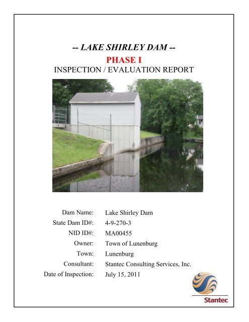
-- LAKE SHIRLEY DAM -- PHASE I - Lunenburg
-- LAKE SHIRLEY DAM -- PHASE I - Lunenburg
-- LAKE SHIRLEY DAM -- PHASE I - Lunenburg

Create successful ePaper yourself
Turn your PDF publications into a flip-book with our unique Google optimized e-Paper software.
-- <strong>LAKE</strong> <strong>SHIRLEY</strong> <strong>DAM</strong> --<br />
<strong>PHASE</strong> I<br />
INSPECTION / EVALUATION REPORT<br />
Dam Name:<br />
State Dam ID#:<br />
NID ID#:<br />
Owner:<br />
Town:<br />
Consultant:<br />
Date of Inspection:<br />
Lake Shirley Dam<br />
4-9-270-3<br />
MA00455<br />
Town of <strong>Lunenburg</strong><br />
<strong>Lunenburg</strong><br />
Stantec Consulting Services, Inc.<br />
July 15, 2011<br />
Lake Shirley Dam ,<strong>Lunenburg</strong>, MA Date of Inspection: July 15, 2011
EXECUTIVE SUMMARY<br />
This report documents observations and evaluation of Lake Shirley Dam located in <strong>Lunenburg</strong>,<br />
Massachusetts based on a visual dam safety inspection conducted by Stantec Consulting<br />
Services, Inc. of Westford, Massachusetts on July 15, 2011. The Dam consists of an earthen<br />
embankment with a primary spillway and low-level outlet system. The dam is classified as a<br />
LARGE size, HIGH hazard potential structure. The dam is in SATISFACTORY condition overall<br />
with no major dam safety deficiencies noted based on our inspection. However, several issues<br />
were identified that should be addressed to preserve the integrity and functionality of the dam:<br />
• The upstream slopes at the ends of the wave wall are located on private property and are<br />
overgrown with trees and brush preventing a thorough inspection of these areas.<br />
• Minor outward movement and vertical cracks were observed along the wave wall.<br />
• Erosion was observed at the right end of the wave wall on the upstream slope.<br />
• Standing water and soft ground were observed at the toe of the downstream slope to the<br />
left of the primary spillway. The toe drain pipes on both sides of the spillway discharge<br />
channel had a video inspection performed during the inspection which showed that the<br />
pipes were not blocked. Reportedly there was difficulty in grading this area during the<br />
dam reconstruction due to springs in this area.<br />
• Minor cracks and spalls were observed on the primary spillway weir and channel walls.<br />
• The outlet works gates clog with leaves and debris when operated. The gate operator<br />
wheels are tight and can be difficult to operate.<br />
Stantec Consulting Services, Inc. recommends the following actions to address deficiencies<br />
detected during the inspection and evaluation:<br />
• Remove debris that becomes lodged on the primary spillway weir or in the discharge<br />
channel to ensure free flow conditions through the system.<br />
• Monitor the upstream wave walls for vertical cracks and rotation/tilting.<br />
• Monitor the wet area at the left downstream area of the dam. Place grade stakes at the<br />
extents of the wet area and take regular photographs to document the size of the area in<br />
relation to lake stage.<br />
• Monitor the surficial spalling and cracking of the primary spillway weir and training walls.<br />
• Remove brush up to 4 in. in diameter at the right and left ends of the upstream wave<br />
walls and on the downstream slope near the left abutment (private property). Inspect<br />
these areas for any deficiencies not detected during this inspection.<br />
• Remove loose soil and organics from the area around the right end of the wave wall.<br />
Place a layer of 6 in. riprap bedded in crushed stone overlying filter fabric.<br />
• Consult an Engineer to design repairs to fix the toe drain filter collection system in the<br />
area of the standing water.<br />
• Install a floating boom upstream of the intake structure to reduce the likelihood of<br />
clogging by leaves and debris on the upstream side of the LLO and MLO intakes.<br />
Section 3 of this report provides additional detail related to the recommended actions. A<br />
qualified Professional Engineer experienced in dam safety engineering should conduct the<br />
recommended evaluations, design the necessary repairs and monitor construction of the repairs<br />
to assure they are conducted in accordance with the design.<br />
Lake Shirley Dam ,<strong>Lunenburg</strong>, MA Date of Inspection: July 15, 2011
Dam Evaluation Summary Detail Sheet<br />
1. NID ID:<br />
MA00455<br />
4. Inspection Date: July 15, 2011<br />
2. Dam Name: Lake Shirley Dam<br />
5. Last Insp. Date: July 16, 2009<br />
3. Dam Location: <strong>Lunenburg</strong>, MA<br />
6. Next Inspection: July 15, 2013<br />
7. Inspector: Nicholas C. D'Agostino, PE<br />
8. Consultant: Stantec Consulting Services, Inc.<br />
9. Hazard Code: High 9a. Is Hazard Code Change Requested?: No<br />
10. Insp. Frequency: 2 Years 11. Overall Physical Condition of Dam:<br />
Satisfactory<br />
12. Spillway Capacity (% SDF) 100% with no acion bty Caretaker<br />
E1. Design Methodology: 4 E7. Low-Level Discharge Capacity: 4<br />
E2. Level of Maintenance: 4 E8. Low-Level Outlet Physical Condition: 5<br />
E3. Emergency Action Plan: 5 E9. Spillway Design Flood Capacity: 5<br />
E4. Embankment Seepage: 5 E10. Overall Physical Condition of the Dam: 4<br />
E5. Embankment Condition: 5 E11. Estimated Repair Cost: 15 to 25<br />
E6. Concrete Condition: 5<br />
Evaluation Description<br />
E1: DESIGN METHODOLOGY E7: LOW-LEVEL OUTLET DISCHARGE CAPACITY<br />
1. Unknown Design – no design records available 1. No low level outlet, no provisions (e.g. pumps, siphons) for emptying pond<br />
2. No design or post-design analyses 2. No operable outlet, plans for emptying pond, but no equipment<br />
3. No analyses, but dam features appear suitable 3. Outlet with insufficient drawdown capacity, pumping equipment available<br />
4. Design or post design analysis show dam meets most criteria 4. Operable gate with sufficient drawdown capacity<br />
5. State of the art design – design records available & dam meets all criteria 5. Operable gate with capacity greater than necessary<br />
E2: LEVEL OF MAINTENANCE E8: LOW-LEVEL OUTLET PHYSICAL CONDITION<br />
1. Dam in disrepair, no evidence of maintenance, no O&M manual 1. Outlet inoperative needs replacement, non-existent or inaccessible<br />
2. Dam in poor level of upkeep, very little maintenance, no O&M manual 2. Outlet inoperative needs repair<br />
3. Dam in fair level of upkeep, some maintenance and standard procedures 3. Outlet operable but needs repair<br />
4. Adequate level of maintenance and standard procedures 4. Outlet operable but needs maintenance<br />
5. Dam well maintained, detailed maintenance plan that is executed 5. Outlet and operator operable and well maintained<br />
E3: EMERGENCY ACTION PLAN E9: SPILLWAY DESIGN FLOOD CAPACITY<br />
1. No plan or idea of what to do in the event of an emergency 1. 0 - 50% of the SDF or unknown<br />
2. Some idea but no written plan 2. 50-90% of the SDF<br />
3. No formal plan but well thought out 3. 90 - 100% of the SDF<br />
4. Available written plan that needs updating 4. >100% of the SDF with actions required by caretaker (e.g. open outlet)<br />
5. Detailed, updated written plan available and filed with MADCR, annual training 5. >100% of the SDF with no actions required by caretaker<br />
E4: SEEPAGE (Embankments, Foundations, & Abutments) E10: OVERALL PHYSICAL CONDITION OF <strong>DAM</strong><br />
1. Severe piping and/or seepage with no monitoring 1. UNSAFE – Major structural, operational, and maintenance deficiencies<br />
2. Evidence of monitored piping and seepage exist under normal operating conditions<br />
3. No piping but uncontrolled seepage 2. POOR - Significant structural, operation and maintenance deficiencies<br />
4. Minor Controlled seepage seepage or high volumes of seepage with filtered collection are clearly recognized under normal loading conditions<br />
5. No seepage or minor seepage with filtered collection 3. FAIR - Significant operational and maintenance deficiencies, no structural<br />
E5: EMBANKMENT CONDITION (See Note 1) deficiencies. Potential deficiencies exist under unusual loading conditions<br />
1. Severe erosion and/or large trees that may realistically occur. Can be used when uncertainties exist as to<br />
2. Significant erosion or significant woody vegetation critical parameters<br />
3. Brush and exposed embankment soils, or moderate erosion 4. SATISFACTORY - Minor operational and maintenance deficiencies.<br />
4. Unmaintained grass, rodent activity and maintainable erosion Infrequent hydrologic events would probably result In deficiencies.<br />
5. Well maintained healthy uniform grass cover 5. GOOD - No existing or potential deficiencies recognized. Safe performance<br />
E6: CONCRETE CONDITION (See Note 2) is expected under all loading including SDF<br />
1. Major cracks, misalignment, discontinuities causing leaks, E11: ESTIMATED REPAIR COST<br />
seepage or stability concerns Estimation of the total cost to address all identified structural, operational,<br />
2. Cracks with misalignment inclusive of transverse cracks with no maintenance deficiencies. Cost shall be developed utilizing standard<br />
misalignment but with potential for significant structural degradation estimating guides and procedures<br />
3. Significant longitudinal cracking and minor transverse cracking<br />
4. Spalling and minor surface cracking<br />
5. No apparent deficiencies<br />
Changes/Deviations to Database Information since Last Inspection
EXECUTIVE SUMMARY<br />
PREFACE<br />
SECTION 1<br />
TABLE OF CONTENTS<br />
Page No.<br />
1.0 DESCRIPTION OF PROJECT 1<br />
SECTION 2<br />
1.1 General 1<br />
1.1.1 Authority 1<br />
1.1.2 Purpose of Work 1<br />
1.1.3 Definitions 1<br />
1.2 Description of Project 1<br />
1.2.1 Location 1<br />
1.2.2 Owner/Caretaker 2<br />
1.2.3 Purpose of Dam 2<br />
1.2.4 Description of the Dam and Appurtenances 2<br />
1.2.5 Operations and Maintenance 3<br />
1.2.6 DCR Size Classification 3<br />
1.2.7 DCR Hazard Potential Classification 3<br />
1.3 Pertinent Engineering Data 3<br />
1.3.1 Drainage Area 3<br />
1.3.2 Reservoir 4<br />
1.3.3 Discharges at the Dam Site 4<br />
1.3.4 General Elevations<br />
1.3.5 Main Spillway 4<br />
1.3.6 Outlet Structure 4<br />
1.3.7 Design and Construction Records and History 5<br />
1.3.8 Operating Records 5<br />
1.4 Summary Data Table 5<br />
2.0 INSPECTION 6<br />
2.1 Visual Inspection 6<br />
2.1.1 General Findings 6<br />
2.1.2 Dam 6<br />
2.1.3 Appurtenant Structures 7<br />
2.1.4 Downstream Area 8<br />
2.1.5 Reservoir Area 8<br />
2.2 Caretaker Interview 8<br />
Lake Shirley Dam/ Date of Inspection: July 15, 2011<br />
4
TABLE OF CONTENTS<br />
Page No.<br />
2.3 Operation and Maintenance Procedures 9<br />
2.3.1 Operational Procedures 9<br />
2.3.2 Maintenance of Dam and Operating Facilities 10<br />
2.4 Emergency Warning System 10<br />
2.5 Hydraulic/Hydrologic Data 10<br />
2.6 Structural and Seepage Stability 10<br />
2.6.1 Embankment Structural Stability 10<br />
2.6.2 Structural Stability of Non-Embankment Structures 11<br />
2.6.3 Seepage Stability 11<br />
SECTION 3<br />
3.0 ASSESSMENTS AND RECOMMENDATIONS 12<br />
TABLES<br />
FIGURES<br />
APPENDICES<br />
3.1 Assessments 12<br />
3.2 Studies and Analyses 13<br />
3.3 Recurrent Maintenance Recommendations 13<br />
3.4 Recommendations, Maintenance, and Minor Repairs 13<br />
3.5 Remedial Modification Recommendations 14<br />
3.6 Alternatives 14<br />
3.7 Opinion of Probable Construction Cost 14<br />
1.1 Summary Data Table<br />
Figure 1: Locus Plan<br />
Figure 2: Aerial Photograph<br />
Figure 3: Drainage Area<br />
Figure 4: Inundation Zone<br />
Figure 5: Site Sketch<br />
Appendix A: Photographs<br />
Appendix B: Inspection Checklist<br />
Appendix C: Previous Reports and References<br />
Appendix D: Definitions<br />
Lake Shirley Dam ,<strong>Lunenburg</strong>, MA Date of Inspection: July 15, 2011
1.1 General<br />
1.1.1 Authority<br />
SECTION 1<br />
1.0 DESCRIPTION OF PROJECT<br />
The Town of <strong>Lunenburg</strong> Department of Public Works retained Stantec Consulting Services, Inc.<br />
to perform a visual inspection and develop a report of conditions for the dam at the Lake Shirley<br />
Dam in the Town of <strong>Lunenburg</strong>,, Worcester County, Massachusetts. This inspection and report<br />
were performed in accordance with MGL Chapter 253, Sections 44-50 of the Massachusetts<br />
General Laws as amended by Chapter 330 of the Acts of 2002.<br />
1.1.2 Purpose of Work<br />
The purpose of this investigation was to inspect and evaluate the present condition of the dam and<br />
appurtenant structures in accordance with 302 CMR10.07 to provide information that will assist<br />
in both prioritizing dam repair needs and planning/conducting maintenance and operation.<br />
The investigation was divided into four parts: 1) obtain and review available reports,<br />
investigations, and data previously submitted to the owner pertaining to the dam and appurtenant<br />
structures; 2) perform a visual inspection of the site; 3) evaluate the status of an emergency action<br />
plan for the site and; 4) prepare and submit a final report presenting the evaluation of the<br />
structure, including recommendations and remedial actions, and opinion of probable costs.<br />
1.1.3 Definitions<br />
To provide the reader with a better understanding of the report, definitions of commonly used<br />
terms associated with dams are provided in Appendix D. Many of these terms may be included in<br />
this report. The terms are presented under common categories associated with dams which<br />
include: 1) orientation; 2) dam components; 3) size classification; 4) hazard classification; and 5)<br />
miscellaneous.<br />
1.2 Description of Project<br />
1.2.1 Location<br />
Lake Shirley Dam is located in the Town of <strong>Lunenburg</strong> in Worcester County, Massachusetts. The<br />
center of the dam is located at latitude 42.5544N and longitude 71.6750W (WGS 84 datum) as<br />
determined from Google Earth. From the Town of <strong>Lunenburg</strong> Town Hall located at 17 Main<br />
Street, head south on Main Street towards MA-2A. Continue on Lancaster Avenue for 1.2 miles.<br />
Turn sharp left onto Page Street for 0.8 miles. Turn slight right at Burrage Street for1.3 miles.<br />
Turn right at Flat Hill Road for 1.3 miles. Turn left at Sunset Lane for0.6 miles. Turn slight left<br />
at Robbs Hill Road for 0.6 miles. Continue on Catacunemaug Road for 0.1 miles. Turn right at<br />
Fire Road 18, the dam will be located to the right. The location of Lake Shirley Dam is shown in<br />
Figure 1. An aerial photograph of the dam is provided as Figure 2.<br />
Lake Shirley Dam ,<strong>Lunenburg</strong>, MA -1- Date of Inspection: July 15, 2011
1.2.2 Owner/Caretaker<br />
See Table 1.1 for current owner and caretaker data (names and contact information).<br />
1.2.3 Purpose of the Dam<br />
Lake Shirley Dam was originally used to impound water to provide mill power. The dam now<br />
impounds Lake Shirley, which is used for recreation purposes. Dubois & King (2007) reported<br />
that Lake Shirley has an influence upon the groundwater levels which surround the impoundment.<br />
1.2.4 Description of the Dam and Appurtenances<br />
Lake Shirley Dam impounds Catacoonamug Brook to form Lake Shirley in the Town of<br />
<strong>Lunenburg</strong>, Massachusetts as presented o Figure 1, “Locus Map.” A dam was originally<br />
constructed at this location for mill power circa 1852. The dam was washed out in 1856 and<br />
rebuilt in 1857. The dam was reconstructed to its current configuration I 1996 1nd 1997 (Dubois<br />
& King, 2007) and is approximately 420 feet in length. The dam has a primary spillway and<br />
outlet works. There is no auxiliary spillway at this dam.<br />
The upstream face of the dam consists of a reinforced concrete wave wall extending to the left<br />
and right of the centrally located primary spillway. The wave walls do not extend to the<br />
abutments nor do they extend to the dam crest. The top of the wave wall to the right of the<br />
spillway is at El 302.7 (Dubois & King, 2007). The wave wall to the left of the spillway is to one<br />
foot to two feet lower than the wall to the right of the spillway. All elevations in this report<br />
reference the National Geodetic Vertical Datum (NGVD).<br />
Grass surfaced earthen slopes extend above the wave walls to the crest of the dam. The slope is<br />
reportedly 3 horizontal (H) to 1 vertical (V) to the left of the spillway and 5H to 1V to the right of<br />
the spillway (Dubois & King, 2007). Near the right abutment, the upstream slope is vegetated<br />
with trees and brush and is on private property. The upstream slope near the left abutment is a<br />
combination of beach area and trees and is also on private property.<br />
The crest of the primary section of the embankment is approximately 15 feet wide and grass<br />
surfaced. The crest of the embankment is reportedly at El 307.67 (Dubois & King, 2007). From<br />
the spillway, the embankment extends approximately 190 feet to the right abutment. An access<br />
gate for maintenance and dam operation is located near the right abutment. The embankment<br />
crest extends approximately 90 feet to the left of the spillway where it meets private property.<br />
The private home site is essentially part of the embankment and may have ben the former site of a<br />
mill structure associated with the dam. This portion of the embankment widens to between 40<br />
feet an over 120 feet and extends approximately 210 feet to the left where it meets natural ground<br />
that slopes up and away from the dam (the left abutment). The private property currently<br />
includes a house, driveway, other secondary buildings and site improvements.<br />
The downstream slopes of the embankment are graded at approximately 2.H to 1V and are grass<br />
surfaced. A toe drain system was installed along the toe of the slope to the left and right of the<br />
primary spillway as part of the reconstruction of the dram in 1997. The toe drain system<br />
reportedly consists of perforated PVC pipes surrounded by a sand filter that discharges into the<br />
riprap lined channel of Catacoonamug Brook. A reinforced concrete bridge crosses over the<br />
spillway channel to allow access to both sides of the dam embankment.<br />
Lake Shirley Dam ,<strong>Lunenburg</strong>, MA -2- Date of Inspection: July 15, 2011
There is a gatehouse structure located immediately to the right of the spillway which houses a low<br />
level outlet (LLO) and a mid level outlet (MLO). The gatehouse is a wood framed structure with<br />
a concrete dry well valve pit. The invert of the MLO and LLO are at El 292.00 and El 288.25,<br />
respectively, (Dubois & King, 1995). Both outlets are controlled by 24-inch gate valves that<br />
discharge into one 30-inch discharge pipe. The 30-inch diameter pipe outlets through the right<br />
training wall of the spillway discharge channel. The valves are operated via hand wheel operators<br />
located in the gatehouse.<br />
1.2.5 Operations and Maintenance<br />
An Operations and Maintenance Manual was prepared for the dam by Weston & Sampson<br />
Engineers, Inc. 2009. The assigned Caretaker operates the LLO and MLO valves and performs<br />
regular visual inspections of the structure. The Caretaker keeps records of gate operation, reason<br />
for operation, and lake levels during operation. The valves are operated to maintain minimal flow<br />
in Catacoonamug Brook downstream of the dam based on twice weekly staff gauge readings<br />
obtained at the Catacunemaug Road Bridge. In the fall (October and November) prior to ice<br />
formation on the lake, the gates are opened and the pond level lowered 6 feet to control plant<br />
growth and allow beach/dock maintenance. The water level in the lake is returned to normal pool<br />
levels with discharge over the spillway by April 1 st each year. The Lake Shirley Improvement<br />
Corporation hires a landscape company to mow the earth embankment sections on Town property<br />
on a monthly basis.<br />
1.2.6 DCR Size Classification<br />
Lake Shirley Dam has a height of dam of approximately 21 feet and a maximum storage capacity<br />
of 7,719 acre-feet (Dubois & King, 20). Refer to Appendix D for definitions of height of dam and<br />
storage. Therefore, in accordance with Department of Conservation and Recreation Office of<br />
Dam Safety classification, under Commonwealth of Massachusetts dam safety rules and<br />
regulations stated in 302 CMR 10.00 as amended by Chapter 330 of the Acts of 2002, Lake<br />
Shirley Dam is a Large size structure.<br />
1.2.7 DCR Hazard Potential Classification<br />
Lake Shirley Dam is located upstream of Catacoonmaug Brook, Catacunemaug Road Bridge,<br />
residential homes, Brook Trail Bridge, a railroad bridge, Leominster Road Bridge, Shaker Road,<br />
and Lowell Road. It appears that a failure of the dam at maximum pool may cause loss of life and<br />
serious damage to homes, industrial or commercial facilities, important public utilities, main<br />
highways, or railroads. Therefore, in accordance with Department of Conservation and<br />
Recreation classification procedures, under Commonwealth of Massachusetts dam safety rules<br />
and regulations stated in 302 CMR 10.00 as amended by Chapter 330 of the Acts of 2002, Forge<br />
Pond Dam should be classified as a High (Class I) hazard potential dam. The Hazard Potential<br />
Classification recommendation is consistent with the Hazard Potential Classification on record<br />
with the Office of Dam Safety for Lake Shirley Dam.<br />
1.3 Pertinent Engineering Data<br />
1.3.1 Drainage Area<br />
The drainage area for Lake Shirley Dam is approximately14.3 square miles and extends through<br />
the communities of Leominster, Lancaster, and Shirley, but is primarily located in the Town of<br />
Lake Shirley Dam ,<strong>Lunenburg</strong>, MA -3- Date of Inspection: July 15, 2011
<strong>Lunenburg</strong>. Multiple streams and brooks flow into Lake Shirley including Catacoonamug Brook<br />
and Easter Brook. Located in the upper portions of the watershed are Lake Whalom, Massapoag<br />
Brook, Turkey Hill Pond, and White Rabbit Swap. The drainage area includes some hilly terrain<br />
as well as low lying wetlands. The elevation difference across the watershed is approximately<br />
375 feet.<br />
1.3.2 Reservoir<br />
See Table 1.1 for data about normal, maximum, and spillway design flood (SDF) pools. These<br />
data were taken from the 2007 Phase I Inspection Report as reported by Weston & Sampson in<br />
the 2009 Phase I Report.<br />
1.3.3 Discharges at the Dam Site<br />
According to the 2007 Phase I Report, the spillway can reportedly discharge approximately 3,570<br />
cfs with the water level in the lake at the dam crest (Maximum Pool). The Caretaker indicated<br />
that the maximum depth of flow over the spillway crest is 22 inches. The Dam Caretaker also<br />
indicated that 80 turns of the MLO gate are required to maintain minimum flows in the<br />
downstream brook.<br />
1.3.4 General Elevations (feet)<br />
A. Top of Dam 307.67<br />
B. Spillway Design Flood Pool 307.1<br />
C. Normal Pool 298.50<br />
D. Spillway Crest 298.25<br />
E. Upstream Water at Time of Inspection 298.50<br />
F. Downstream Water at Time of Inspection 287±<br />
G. Streambed at Toe of the Dam 287±<br />
H. Low Point along Toe of the Dam 290±<br />
1.3.5 Main Spillway Data<br />
A. Type Concrete Ogee<br />
B. Weir Length (feet) 30<br />
C. Weir Crest Elevation (feet) 298.25<br />
D. Upstream Channel Elevation 287.5<br />
E. Downstream Channel Elevation 287.0<br />
F. Downstream Outlet Invert or Channel Bottom Elevation 287.0<br />
1.3.6 Outlet Structure<br />
A. Type Mid-Level Outlet pipe, 24 inch dia C.I.<br />
Low-Level Outlet pipe, 24 inch dia. C.I.<br />
Both outlets controlled by gate valves into one<br />
30-inch dia. pipe<br />
B. Invert MLO Elevation 292.00<br />
C. Invert LLO Elevation 288.25<br />
D. Outlet Works Invert Out let Elevation 288.50<br />
E. Valve Type Gate Valve<br />
F. Valve Pit Floor Elevation 286.5<br />
Lake Shirley Dam ,<strong>Lunenburg</strong>, MA -4- Date of Inspection: July 15, 2011
1.3.7 Design and Construction Records and History<br />
A dam was originally constructed at this location for mill power circa 1852. That dam was<br />
washed out in 1856 and rebuilt in 1857. The dam was rehabilitated to its current configuration in<br />
1996 and 1997. The 1996 and 1997 rehabilitation included raising the dam crest several feet to<br />
increase the freeboard during the Spillway Design Flood (SDF), flattened the downstream slope<br />
to improve stability, installing a toe drain filter system along the downstream toe of the dam,<br />
installing a 30 feet wide reinforced concrete spillway, and installing a new gatehouse and outlet<br />
works system. The Record Drawings from this reconstruction are available from the Dam Owner<br />
and Caretaker.<br />
1.3.8 Operating Records<br />
The Dam Caretaker keeps records of valve operations and lake elevations. The records are kept<br />
in the gatehouse at the dam.<br />
1.4 Summary Data Table<br />
See Table 1.1 Summary Data Table.<br />
Lake Shirley Dam ,<strong>Lunenburg</strong>, MA -5- Date of Inspection: July 15, 2011
1.1 Summary Data Table<br />
Required Phase I Report Data Data Provided by the Inspecting Engineer<br />
National ID # MA00455<br />
Dam Name Lake Shirley Dam<br />
Dam Name (Alternate) Shirley Reservoir Dam<br />
River Name Catacoonamug Brook, tributary to Nashua River<br />
Impoundment Name Lake Shirley<br />
Hazard Class High<br />
Size Class Large<br />
Dam Type Earth Embankment<br />
Dam Purpose Recreation<br />
Structural Height of Dam (feet) 21<br />
Hydraulic Height of Dam (feet) 20.1<br />
Drainage Area (sq. mi.) 14.3<br />
Reservoir Surface Area (sq. mi.) 0.61<br />
Normal Impoundment Volume (acre-feet) 2,969<br />
Max Impoundment Volume ((top of dam) acre-feet) 7,719<br />
SDF Impoundment Volume* (acre-feet) 6,266<br />
Spillway Type Ogee Weir<br />
Spillway Length (feet) 30<br />
Freeboard at Normal Pool (feet) 5<br />
Principal Spillway Capacity* (cfs) 3,570<br />
Auxiliary Spillway Capacity* (cfs) Not Appicable<br />
Low-Level Outlet Capacity* (cfs) Not determined<br />
Spillway Design Flood* (flow rate - cfs) 1/2 PMF; 8,110<br />
Winter Drawdown (feet below normal pool) 6<br />
Drawdown Impoundment Vol. (acre-feet) Not determined<br />
Latitude 42.5544N<br />
Longitude 71.6750W<br />
City/Town <strong>Lunenburg</strong><br />
County Name Worcester<br />
Public Road on Crest Not Applicable<br />
Public Bridge over Spillway Not Applicable<br />
EAP Date (if applicable) 1-Oct-10<br />
Owner Name Tow of <strong>Lunenburg</strong><br />
Owner Address 17 Main Street, PO Box 135<br />
Owner Town <strong>Lunenburg</strong><br />
Owner Phone (978) 582-4130<br />
Owner Emergency Phone (978) 582-4531 (police)<br />
Owner Type Municipality<br />
Caretaker Name Ron Wilson<br />
Caretaker Address 701 Reservoir Road<br />
Caretaker Town <strong>Lunenburg</strong><br />
Caretaker Phone (978) 582-4086<br />
Caretaker Emergency Phone (978) 852-2411 (cell)<br />
Date of Field Inspection 7/14/2011<br />
Consultant Firm Name Stantec Consulting Services, Inc.<br />
Inspecting Engineer Nicholas C. D'Agostino, PE<br />
Engineer Phone Number (978) 577-1440<br />
*In the event a hydraulic and hydrologic analysis has not been completed for the dam, indicate "No H&H" in this table, recommendation<br />
section shall include specific recommendation to hire a qualified dam engineering consultant to conduct analysis to determine spillway<br />
adequacy in conformance with 302 CMR 10.00.<br />
Lake Shirley Dam/ <strong>Lunenburg</strong>, MA Date of Inspection: July 15, 2011
2.1 Visual Inspection<br />
SECTION 2<br />
2.0 INSPECTION<br />
Lake Shirley Dam was inspected on July 14, 2011. At the time of the inspection, the<br />
weather was sunny with an average temperature of 85 degrees. Photographs to document<br />
the current conditions of the dam were taken during the inspection and are included in<br />
Appendix A. The level of the impoundment was approximately 3-inches over the<br />
spillway crest or at El 298.5. Underwater areas were not inspected. A copy of the<br />
inspection checklist is included in Appendix B.<br />
2.1.1 General Findings<br />
2.1.2 Dam<br />
In general, Lake Shirley Dam was found to be in Satisfactory condition. The specific<br />
concerns are identified in more detail in the sections below:<br />
Abutments<br />
The right and left abutments of the dam are located on private property. The upstream<br />
slope of the right abutment is overgrown with trees and brush/bushes. The upstream<br />
slope of the left abutment also is overgrown with trees and brush. The crest of the left<br />
abutment consists of a private lawn, driveway, and buildings. The crest width of the left<br />
abutment increases from the rebuilt dam to roughly 120 feet. No signs of abutment<br />
seepage, surface cracking or displacement were observed. The property owner has<br />
recently planted three tree saplings along the top of the embankment at the left abutment.<br />
Upstream Face<br />
The upstream vertical reinforced concrete wave walls protect the upstream face of the<br />
dam. The wall alignment is good with the exception of minor outward movement to the<br />
right of the gatehouse. The overall wall condition is satisfactory. The wall pre-dates the<br />
reconstruction of the dam in 1996-1997 and is shown in the design drawings (Dubois &<br />
King, 1995). The wave walls do not fully extend to either of the two abutments. No<br />
sinkholes were observed behind the walls. Several vertical cracks were noted and an<br />
attempt was made to seal/caulk the openings. The top of the left wave wall is lower than<br />
the top of the right wall.<br />
Slides, sloughs, or scraps were not observed on the earth embankment slope upgradient of<br />
the wave walls extending to the dam crest. The slopes are protected with wellmaintained<br />
grass cover. Brush and trees are present at the right and left ends of the wave<br />
walls where the walls contact private property and were left in place by the designers of<br />
the dam reconstruction (Dubois & King, 1995). Minor erosion was noted around the right<br />
end of the wave wall. No unusual movement of the slope was observed.<br />
Lake Shirley Dam ,<strong>Lunenburg</strong>, MA -6- Date of Inspection: July 15, 2011
Crest<br />
Most of the dam crest has a well maintained grass cover. Surface cracking, sinkholes,<br />
rut, or animal burrows were not observed during the inspection. The2009 Phase I Dam<br />
Safety Inspection Report noted that the crest of the dam was about 4-inches lower than<br />
the design elevations for the dam crest. It is unknown if this was an as-built condition<br />
form the dam reconstruction in 1996/1997 or due to settlement. The horizontal alignment<br />
of the dam is good. The crest at the left abutment is on private property and consists of a<br />
well maintained lawn, driveway, and buildings. The crest varies from 15 feet to 40 feet<br />
in this area.<br />
Downstream Face<br />
The downstream slope of the dam is vegetated with a good stand of grass that is regularly<br />
mowed. No active seepage was noted along the downstream slope. There were no animal<br />
burrows, slides, sloughing, or scarps observed to the slopes to the right or left of the<br />
spillway.<br />
Drains<br />
There is a seepage collection system along the downstream toe of the embankment with<br />
cleanouts near each abutment and outlets into the spillway discharge channel. Along the<br />
left toe of the embankment there is a wet area that according to one of the adjacent<br />
property owners was caused by a spring in that location that the contractor attempted to<br />
control during the reconstruction of the dam in 1996/1997. The previous inspection<br />
(Weston & Sampson, 2009) noted the presence of this wet area. During the inspection,<br />
the <strong>Lunenburg</strong> DPW retained a contractor to video the condition of the toe drain. The<br />
left drain appeared to have minimal deposition and most of the drain was fully submerged<br />
in the area of the wet area. The right toe drain was clear. Note a week after the<br />
inspection, the DPW had the toe drains cleaned and reportedly the flow from the left<br />
drain improved. It was also noted that there was flow downstream of the wet area/toe<br />
drain that discharges into Catacoonamug Brook.<br />
Instrumentation<br />
There is no instrumentation on the dam. A staff gauge is located at the Catacunemaug<br />
Road Bridge approximately 350 feet downstream of the dam. Flow depth is recorded by<br />
the Dam Caretaker and submitted to the MADEP to verify that minimum base flow in the<br />
stream is being maintained per the Order of Conditions issued for the reconstruction of<br />
the dam.<br />
Access Roads and Gates<br />
The dam is accessed from the right abutment off of Fire Road 18 and Catacunemaug<br />
Road. A gated entrance is located near the right abutment. Vehicular access to the<br />
spillway is possible for authorized personnel. The gatehouse is kept locked and access to<br />
the footbridge over the spillway is also locked.<br />
2.1.3 Appurtenant Structures<br />
Primary Spillway<br />
The primary spillway is a reinforced concrete ogee shaped weir with concrete training<br />
walls. It is 30 feet wide with an 88 feet long concrete spillway apron chute, concrete<br />
abutment walls. The spillway apron outlets onto a riprap covered channel in<br />
Lake Shirley Dam ,<strong>Lunenburg</strong>, MA -7- Date of Inspection: July 15, 2011
Catacoonamug Brook at El 287. The overall condition of the spillway appears to be<br />
good. The training walls are reinforced concrete. Several minor cracks were observed in<br />
the walls. The spillway is a fixed crest, uncontrolled weir. No unusual movement or<br />
debris on the weir or discharge channel was observed. Multiple small cracks and spalls<br />
were observed on the downstream side of the weir causing minor flow disturbance. The<br />
reinforced concrete bridge over the primary spillway had the surficial spalled concrete<br />
repaired that had been identified in the previous inspection report.<br />
Low-Level Outlets<br />
The outlet works consists of a low level outlet and mid-level outlet. The intake end of the<br />
outlets could not be observed. The trash rack is reported to be a bar rack which is<br />
marginally effective as the gates reportedly become clogged with leaves in the fall and<br />
are cleaned manually. The gates are in good condition, having been installed in 1997 as<br />
part of the dam reconstruction. The operator noted that the gates are stiff to operate.<br />
Reportedly the gate operators, housed within the gate house have not been lubricated<br />
since they were installed in 1997. No seepage or leakage related to the outlet works was<br />
observed. No unusual movement or erosion related to the outlet works was observed.<br />
The gatehouse structure was in good condition.<br />
Auxiliary/Emergency Spillway<br />
There is no auxiliary/emergency spillway at this dam.<br />
Dikes<br />
There are no dikes associated with this dam.<br />
2.1.4 Downstream Area<br />
No abutment leakage or active foundation seepage were observed. Access to the<br />
downstream area is possible by foot. The immediate downstream area at the toe of the<br />
dam is grass covered for approximately 50 feet and then is heavily wooded. The<br />
downstream channel, Catacoonamug Brook, is stone lined and appears to flow freely.<br />
Catacunemaug Road Bridge is located approximately 350 feet downstream of the dam.<br />
2.1.5 Reservoir Area<br />
The lake has an approximate area of 392.9 acres with an irregular shape that has a<br />
maximum length of approximately 7,780 feet and a maximum width of 4,340 feet. The<br />
lake is made up of two large discrete basins (north and south) that converge in on a<br />
shallow, central area enclosed by numerous peninsulas abs coves. The dam is located<br />
along the eastern shoreline in a cove of the southern pool area. The lake depth was not<br />
obtained, but the water level at the time of the inspection was approximately El 298.5.<br />
The shoreline of the lake is wooded with some residential development. The slopes do<br />
not appear to be susceptible to slides or other occurrences that could affect the water level<br />
elevation.<br />
2.2 Caretaker Interview<br />
The Town of <strong>Lunenburg</strong> appoints a dam keeper and assistant da keeper annually from the<br />
Lake Shirley Improvement Corporation. Currently, the dam keeper is Mr. Ron Wilson<br />
and the assistant dam keeper is Mr. Richard Patry, two lake residents. The previous dam<br />
Lake Shirley Dam ,<strong>Lunenburg</strong>, MA -8- Date of Inspection: July 15, 2011
keeper was Mr. Earl Graves. Messrs. Wilson, Patry, and Graves were present during the<br />
inspection. The following information was provided during the inspection:<br />
The maximum depth of flow over the spillway is approximately 22 inches<br />
In order to keep minimum flow into the brook, the mid- level outlet gate control<br />
gate is turned 80 revolutions.<br />
The staff gauge installed on the downstream bridge is monitored twice per week<br />
and the readings submitted to the MADEP in accordance with the Order of<br />
Conditions from the reconstruction of the dam.<br />
The earth embankment is mowed by a landscaping company, retained by the Lake<br />
Shirley Improvement Corporation on a monthly basis.<br />
The LLO and MLO gates clog on a fairly frequent basis requiring the fire<br />
department dive team to remove the leaves and debris in the fall. Mr. Wilson was<br />
interested in a modification to the bar screen/ trash rack to reduce the frequency of<br />
screen cleaning.<br />
Each gate operator requires 300 revolutions to fully open each of the gates.<br />
The Operations and Maintenance Manual does not address the gate operators. The<br />
operators have not been greased since they were installed in 1997.<br />
The spalled concrete on the decking of the footbridge over the spillway was<br />
repaired, but the repair is showing early signs of deterioration.<br />
According to the resident at the right abutment, the wet area along the downstream<br />
toe of the slope to the left of the spillway has been an issue since the dam was<br />
rebuilt in 1997 and is spring fed.<br />
The outlets are operated in the fall and during high flow events throughout the<br />
year to maintain the lake level with between 4-inches to 10-inches of flow over<br />
the spillway crest without causing downstream flooding.<br />
The lake level is lowered by about 6 feet in October/November prior to ice<br />
formation in the lake. MADEP requires that the lake level be at normal pool with<br />
flow over the spillway each year by April 1 st . Minimum downstream flow to the<br />
brook must be maintained throughout the year.<br />
The Operation & Maintenance Plan and Emergency Action Plan were updated by<br />
Weston & Sampson Engineers, Inc. in October 2010.<br />
2.3 Operation and Maintenance Procedures<br />
The Operations & Maintenance Manual for Lake Shirley Dam was prepared by Weston &<br />
Sampson and dated October 2010 and is kept by the Caretaker and a copy is on site at the<br />
gatehouse.<br />
2.3.1 Operational Procedures<br />
The low-level outlet and mid-level outlet gate valves are the only operating works at the<br />
dam and are exercised at least once per month. The gates are operated to lower the pool<br />
elevation during the winter month to control weed growth and allow beach and dock<br />
Lake Shirley Dam ,<strong>Lunenburg</strong>, MA -9- Date of Inspection: July 15, 2011
maintenance. The water level is lowered 6 feet beginning in October and November<br />
before ice forms in the lake. Lake Shirley is returned to normal pool elevation with<br />
discharge over the spillway by April 1. A minimum base flow is required to be passed by<br />
the da at all times to keep minimum flow in Catacoonamug Brook. Eighty turns on the<br />
mid-level outlet gate operator wheel are required to meet the minimum discharge<br />
requirements. Readings are taken downstream of the dam at the staff gauge at<br />
Catacunemaug Road Bridge biweekly<br />
2.3.2 Maintenance of Dam and Operating Facilities<br />
Maintenance is conducted at the dam on an as needed basis. The embankment is mowed<br />
monthly<br />
2.4 Emergency Warning System<br />
There is no Emergency Warning System in place at the dam. An Emergency Action Plan<br />
(EAP) has been developed and updated by Weston & Sampson in October 2010.<br />
2.5 Hydrologic/Hydraulic Data<br />
A Hydrologic and Hydraulic analysis of the watershed and the dam was performed by<br />
Dubois & King in 1995 and 1996 as part of the dam rehabilitation design. Dubois &<br />
King reportedly utilized the US Army Corps of Engineers HEC-1 Flood Hydrology<br />
computer model. The following results were taken from the previous Phase I Report<br />
dated July 16, 2009:<br />
A. Spillway Design Flood (SDF) Return Period ½ PMF<br />
B. Precipitation (inches) and methodology Not Determined<br />
C. SDF Inflow (cfs) 8,110<br />
D. SDF Outflow (cfs) 3.052<br />
E. Principal Spillway Capacity (cfs) 3,750<br />
F. Auxiliary Spillway Capacity (cfs Not Applicable<br />
G. Low-level Outlet Capacity (cfs) Not Determined<br />
H. Percentage of the SDF that can be safely routed through<br />
the reservoir without overtopping the dam. 100<br />
I. Maximum Depth of Overtopping for SDF (feet) Not Applicable<br />
J. Maximum Duration of Overtopping for SDF (hours) Not Applicable<br />
Dam does not overtop during the spillway design flood. There is approximately 0.6 feet<br />
of freeboard based on top of dam at El 307.67.<br />
2.6 Structural and Seepage Stability<br />
2.6.1 Embankment Structural Stability<br />
Engineering analyses of static and dynamic stability of the embankment were not<br />
available for review at the time of this report and have not been conducted for this study.<br />
Reportedly, Dubois & King conducted slope stability analyses as part of the rehabilitation<br />
design. Based on the findings of this study, the downstream slopes of the dam were<br />
flattened from 1.75H to 1V to 2.H to 1V with granular material that is more pervious than<br />
Lake Shirley Dam ,<strong>Lunenburg</strong>, MA -10- Date of Inspection: July 15, 2011
the existing embankment material. A toe drain seepage collection system was also<br />
installed at the toe of the downstream slope. Based upon visual observations, the Lake<br />
Shirley Dam embankment appears to be stable.<br />
2.6.2 Structural Stability of Non-Embankment Structures<br />
The non-embankment structures include the upstream wave wall, the primary spillway<br />
weir and discharge channel walls, the access bridge over the spillway, and the gatehouse<br />
structure. Engineering analyses of static and dynamic stability of the non-embankment<br />
structures were not available for review at the time of this report and have not been<br />
conducted as part of this study. Based on visual observations, the non-embankment<br />
structures for Lake Shirley Dam appear to be stable.<br />
2.6.3 Seepage Stability<br />
Active seepage was not observed along the downstream toe of the slope. The flow<br />
through the spillway discharge channel prevented the detection of any seepage or leakage<br />
into the channel. There is a wet area to the left of the spillway at the toe of slope that<br />
coincides with the location of the toe drain. Reportedly this area is spring fed and was<br />
wet during the reconstruction of the dam. At the time of the inspection, the <strong>Lunenburg</strong><br />
Department of Public Works had retained a contractor to video the condition of the<br />
interior of the toe drain pipeline.<br />
Lake Shirley Dam ,<strong>Lunenburg</strong>, MA -11- Date of Inspection: July 15, 2011
3.1 Assessments<br />
SECTION 3<br />
3.0 ASSESSMENTS AND RECOMMENDATIONS<br />
In general, the overall condition of Lake Shirley Dam is Satisfactory. The dam was found to<br />
have the following deficiencies:<br />
1. The upstream slopes at the ends of the wave walls that are located on private property<br />
are overgrown with trees and brush preventing a thorough inspection of these areas.<br />
Recently planted trees were observed on the top of the embankment at the left abutment<br />
2. Minor outward movement and vertical cracks were noted along the wave wall.<br />
3. Minor erosion was observed at the right end of the right wave wall on the upstream slope.<br />
4. Standing water was observed at the toe of the downstream slope to the left of the primary<br />
spillway. The condition of the pipe was video recorded at the time of the inspection and<br />
found to not be clogged. The pipe section in the wet area was completely submerged.<br />
5. Minor cracks and spalls were observed on the spillway ogee weir.<br />
6. The outlet works gates clog with leaves and debris when operated. The gate operator<br />
wheels are stiff to operate. The Operations & Maintenance Manual does not address<br />
periodic lubricating the operator mechanism.<br />
Previously Identified Deficiency Resolution or Current Condition<br />
Upstream slopes at ends of wave walls<br />
overgrown with trees and brush.<br />
Minor outward movement and vertical cracks<br />
observed along the wave wall<br />
Minor erosion at the downstream ends of the<br />
right and left spillway training walls<br />
Animal burrows observed on upstream and<br />
downstream slopes<br />
Standing water and iron staining observed at<br />
toe of downstream slope to left of primary<br />
spillway. Could be result of clogged drain<br />
seepage collection pipe.<br />
Bare areas and weeds observed in the grass<br />
cover on the embankment<br />
Spalling on the concrete catwalk across the<br />
primary spillway<br />
Resident at left abutment has planted trees on<br />
the top of dam informed that trees should be<br />
relocated off of dam crest<br />
Evidence of crack sealing/caulking<br />
performed. Wall movement monitored by<br />
dam caretaker<br />
No Action<br />
None observed<br />
<strong>Lunenburg</strong> DPW had pipe video performed<br />
during inspection. Pipe is not clogged.<br />
Resident indicated that area was spring fed<br />
and was a problem during dam rehabilitation<br />
in 1997.<br />
No bare areas on embankment slopes noted<br />
during inspection<br />
Spalling repaired on bridge<br />
Lake Shirley Dam ,<strong>Lunenburg</strong>, MA -12- Date of Inspection: July 15, 2011
Previously Identified Deficiency Resolution or Current Condition<br />
Outlet works gates clog with leaves and debris<br />
when operated. Gate operator wheels stiff to<br />
operate<br />
Develop a formalized Operations &<br />
Maintenance (O&M) manual<br />
Fire Department divers clear debris from trash<br />
rack in fall. Gate operators have not been<br />
lubricated since installation.<br />
O&M Manual dated October 2010 on hand by<br />
Dam caretaker and in Gatehouse<br />
The following recommendations and remedial measures generally describe the recommended<br />
approach to address current deficiencies at the dam. Prior to undertaking recommended<br />
maintenance, repairs, or remedial measures, the applicability of environmental permits needs to<br />
be determined for activities that may occur within resource areas under the jurisdiction of local<br />
conservation commissions, MADEP, or other regulatory agencies.<br />
3.2 Studies and Analyses<br />
It is recommended that the Town of <strong>Lunenburg</strong> engage the services of a Registered Professional<br />
Engineer as defined in 310 CMR 10.03 to complete the following studies in accordance with dam<br />
safety regulations:<br />
Perform a seepage evaluation of the dam to the left of the spillway by installing<br />
piezometers on the top of the dam and on each side of the toe drain to establish if there<br />
are uplift pressures acting on the dam due to seepage through the embankment or to<br />
confirm that the wet area is spring fed. Recommend necessary modifications to control<br />
water flow.<br />
3.3 Recurrent Maintenance Recommendations<br />
It is recommended that the Owner/Caretaker conduct the following routine observation and<br />
maintenance activities:<br />
Observe the condition of the dam for changes from those identified in this report.<br />
Observations should be made quarterly, as well as during and following rainfall events<br />
that exceed the 25-year, 24-hour storm (approximately 5-inches of rain in a 24 hour<br />
period).<br />
Remove debris that becomes lodged on the primary spillway weir or in the discharge<br />
channel to ensure free flow conditions through the system.<br />
Monitor the vertical cracks and outward movement of the upstream wave walls.<br />
Monitor the wet area at the left downstream toe of the embankment. Place grade stakes<br />
at the extents of the wet area and take regular photographs to document the size of the<br />
wet area in relation to lake stage.<br />
Monitor the surficial spalling and cracking of the primary spillway ogee weir. Make<br />
repairs to concrete surface in fall (early November) after the lake level is drawn down.<br />
Lake Shirley Dam ,<strong>Lunenburg</strong>, MA -13- Date of Inspection: July 15, 2011
Monitor large trees along the dam abutments during periods of high winds for uprooting.<br />
Remove tree and stump/roots and backfill the hole with a compacted backfill material.<br />
3.4 Minor Repair Recommendations<br />
It is recommended the Owner/Caretaker conduct the following minor repair activities as soon as<br />
practicable to limit the risk of dam failure until appropriate dam repairs are designed and<br />
constructed. These activities may require design by a Registered Professional Engineer and/or<br />
permit application filing with the local conservation commission and or MADEP.<br />
Remove brush up to 4-inches in diameter at the right and left ends of the upstream wave<br />
walls. Inspect these areas for any deficiencies not detected during this inspection.<br />
Install a floating boom on the upstream side of the mid-level outlet intake to reduce the<br />
amount of clogging by leaves and debris.<br />
3.5 Remedial Modifications Recommendations<br />
None recommended at this time.<br />
3.6 Alternatives<br />
There are no recommended alternatives for this dam.<br />
3.7 Opinion of Probable Construction Costs<br />
Our estimate of the probable range of costs to implement the recommendations listed above<br />
follows. These estimates are based on limited information and are not intended as a basis for<br />
capital improvement budgeting.<br />
Studies and Analyses<br />
$12,000 to $15,000 for seepage evaluation<br />
Recurrent Maintenance<br />
$1,500 to $2,500 annually<br />
Minor Repairs<br />
$7,000 to $10,000 for floating boom and vegetation removal<br />
$15,000 to $25,000 for seepage collection system improvements and/or fill placement to<br />
raise grade in wet area.<br />
Lake Shirley Dam ,<strong>Lunenburg</strong>, MA -14- Date of Inspection: July 15, 2011
FIGURES<br />
Lake Shirley Dam/<strong>Lunenburg</strong>, MA Date of Inspection: July 15, 2011
FIGURES INSTRUCTION PAGE:<br />
Figures should include:<br />
1. Locus Plan - Dam and Impoundment Area:<br />
A Color locus map developed from USGS Quad sheet or GIS mapping that depicts the<br />
location of the dam, the entire impoundment, and the general area of the dam. The<br />
plan should include a scale, north arrow and be presented with a title block that<br />
indicates the dam name, NID ID #, town, USGS quadrangle, the source of the map, and<br />
the Latitude/Longitude point location of the dam. The recommended size for this figure<br />
is 8.5 x 11.<br />
2. Aerial Photograph – Dam and Impoundment Area:<br />
A color (if available) or black and white highest available resolution ortho-photo locus<br />
map that depicts the location of the dam, the entire impoundment, and the general area<br />
of the dam. The plan should include a scale, north arrow, and be presented with a title<br />
block that indicates the dam name, NID ID #, town, the source of the map, and the<br />
Latitude/Longitude point location of the dam. The recommended size for this figure is<br />
8.5 x 11.<br />
3. Drainage area:<br />
A Color locus map developed from USGS Quad sheet that depicts the location of the<br />
dam, the entire drainage area delineated on the map. The plan should include a scale,<br />
north arrow and be presented with a title block that indicates the dam name, NID ID #, ,<br />
drainage area in square miles, town, USGS quadrangle, the source of the map, and the<br />
Latitude/Longitude point location of the dam. The recommended size for this figure is<br />
8.5 x 11.<br />
4. Dam and Area Downstream from Dam:<br />
A color locus map developed from USGS Quad sheet that depicts the location of the<br />
dam, the area several miles downstream from the dam likely to be affected by a dam<br />
breach. The plan should include a scale, north arrow and be presented with a title<br />
block that indicates the dam name, NID ID#, town, USGS quadrangle, the source of the<br />
map, and the Latitude/Longitude point location of the dam. The recommended size for<br />
this figure is 8.5 x 11.<br />
5. Dam Site Sketch or Plan (with photo locations/orientation):<br />
Site plan based upon construction plans or information gathered during the inspection.<br />
Plan should include a scale, north arrow, an indication of flow direction, depiction of<br />
photo locations and orientation (for clarity a separate figure showing photo locations<br />
and orientations can be provided in Appendix A), and provide sufficient detail to<br />
identify the dam components and features. The size of this figure should be adjusted in<br />
order to provide a plan of appropriate scale to show relevant site features.<br />
Lake Shirley Dam/<strong>Lunenburg</strong>, MA Date of Inspection: July 15, 2011
APPENDIX A<br />
Photographs<br />
Lake Shirley Dam/<strong>Lunenburg</strong>, MA Date of Inspection: July 15, 2011
Photo 1 Overview of Dam from Upstream<br />
Photo 2 Overview of Dam from Downstream<br />
Lake Shirley Dam/<strong>Lunenburg</strong>, MA Date of Inspection: July 15, 2011
Photo 3 Overview of Upstream Face from Right Abutment<br />
Photo 4 Overview of Upstream Face from Left Abutment<br />
Lake Shirley Dam/<strong>Lunenburg</strong>, MA Date of Inspection: July 15, 2011
Photo 5 Overview of Dam Crest from Right Abutment<br />
Photo 6 Overview of Dam Crest from Left Abutment<br />
Lake Shirley Dam/<strong>Lunenburg</strong>, MA Date of Inspection: July 15, 2011
Photo 7 Overview of Downstream Face from Right Abutment<br />
Photo 8 Overview of Downstream Face from Left Abutment<br />
Lake Shirley Dam/<strong>Lunenburg</strong>, MA Date of Inspection: July 15, 2011
Photo 9 Overview of Spillway from Downstream with Low Level Outlet Pipe<br />
From Gatehouse<br />
Photo 10 Left Spillway Training Wall and Footbridge<br />
Lake Shirley Dam/<strong>Lunenburg</strong>, MA Date of Inspection: July 15, 2011
Photo 11 Close-up View of Ogee Weir Looking Upstream. Minor flow<br />
interruptions are believed to be small spalled areas in<br />
concrete<br />
Photo 12 Overview of Stilling Basin and Downstream Channel<br />
Lake Shirley Dam/<strong>Lunenburg</strong>, MA Date of Inspection: July 15, 2011
Photo 13 Overview of Gatehouse Exterior<br />
Photo 14 Overview of Gatehouse Interior<br />
Lake Shirley Dam/<strong>Lunenburg</strong>, MA Date of Inspection: July 15, 2011
Photo 15 Wet Area at Toe of Dam to Left of Spillway Discharge Channel<br />
Photo 16 Closeout of Wet Area to Left of Spillway Discharge Channel<br />
(Note Standing Water)<br />
Lake Shirley Dam/<strong>Lunenburg</strong>, MA Date of Inspection: July 15, 2011
Photo 17 Toe Drain Cleanout at Left Downstream Abutment<br />
Photo 18 Video Recording Toe Drain from Right Abutment Entrance Point<br />
Lake Shirley Dam/<strong>Lunenburg</strong>, MA Date of Inspection: July 15, 2011
Photo 20 Staff Gauge at Catacunemang Road Bridge<br />
Photo 19<br />
Discharge Channel<br />
Looking North from<br />
Catacunemang Road Bridge<br />
Lake Shirley Dam/<strong>Lunenburg</strong>, MA Date of Inspection: July 15, 2011
Photo 21 Upstream Wave Wall Minor Outward Wall Movement at<br />
Gatehouse to Right of Spillway<br />
Photo 22 Upstream View of Spillway and Caulk Repairs to<br />
Upstream Wave Wall Joints<br />
Lake Shirley Dam/<strong>Lunenburg</strong>, MA Date of Inspection: July 15, 2011
Photo 23 Encroachments at Left Abutment Including Utility Shed, Screen<br />
house, Recently Planted Tree Saplings and Utility Pole<br />
Lake Shirley Dam/<strong>Lunenburg</strong>, MA Date of Inspection: July 15, 2011
APPENDIX B<br />
Inspection Checklist<br />
Lake Shirley Dam/<strong>Lunenburg</strong>, MA Date of Inspection: July 15, 2011
NAME OF <strong>DAM</strong>: Lake Shirley Dam STATE ID #: 4-9-270-3<br />
REGISTERED:<br />
CITY/TOWN: <strong>Lunenburg</strong> COUNTY: Worcester<br />
STATE HAZARD CLASSIFICATION: High<br />
CHANGE IN HAZARD CLASSIFICATION REQUESTED?: No<br />
<strong>DAM</strong> LOCATION:<br />
(street address if known)<br />
Fire Road #18 (off of Catacunemaug Road)<br />
ALTERNATE <strong>DAM</strong> NAME: Shirley Reservoir Dam<br />
USGS QUAD.: Ayer LAT.: 42.5544N LONG.: 71.6750W<br />
DRAINAGE BASIN: Nashua RIVER: Catacoonnamaug Brook, Tributary to Nashua River<br />
IMPOUNDMENT NAME(S): Lake Shirley<br />
TYPE OF <strong>DAM</strong>: Earth Embankment OVERALL LENGTH (FT): 425<br />
PURPOSE OF <strong>DAM</strong>: Recreation<br />
YEAR BUILT:<br />
YES NO<br />
STATE SIZE CLASSIFICATION: Large<br />
STRUCTURAL HEIGHT (FT): 21<br />
EL. NORMAL POOL (FT):<br />
HYDRAULIC HEIGHT (FT): 20.1<br />
EL. MAXIMUM POOL (FT):<br />
FOR INTERNAL MADCR USE ONLY<br />
<strong>DAM</strong> SAFETY INSPECTION CHECKLIST<br />
NID ID #:<br />
<strong>DAM</strong> LOCATION INFORMATION<br />
GENERAL <strong>DAM</strong> INFORMATION<br />
MA00455<br />
NORMAL POOL STORAGE (ACRE-FT): 2,969<br />
1852, rebuilt 1857, Rehabilitaton 1996/1997 MAXIMUM POOL STORAGE (ACRE-FT): 7,719<br />
FOLLOW-UP INSPECTION REQUIRED: YES NO CONDITIONAL LETTER: YES NO<br />
Dam Safety Inspection Checklist v.3.1 Page 1<br />
298.5<br />
307.7
NAME OF <strong>DAM</strong>: Lake Shirley Dam STATE ID #: 4-9-270-3<br />
INSPECTION DATE: July 15, 2011<br />
NID ID #:<br />
OWNER: ORGANIZATION Town of <strong>Lunenburg</strong><br />
CARETAKER: ORGANIZATION Lake Shirley Improvement Corporation<br />
NAME/TITLE Board of Selectmen NAME/TITLE Ron Wilson/Caretaker<br />
STREET 17 Main Street, PO Box 135 STREET 701 Reservoir Road<br />
TOWN, STATE, ZIP <strong>Lunenburg</strong>, MA 01462 TOWN, STATE, ZIP <strong>Lunenburg</strong>, MA 01462<br />
PHONE (978) 582-4130 PHONE (978) 582-7372<br />
EMERGENCY PH. # (978) 582-4531 (police) EMERGENCY PH. # (978) 852-2422 (cell)<br />
FAX<br />
(978) 582-4152 FAX<br />
EMAIL<br />
EMAIL<br />
OWNER TYPE Municipality or Political subdivision<br />
PRIMARY SPILLWAY TYPE Concrete Ogee Weir<br />
SPILLWAY LENGTH (FT) 30 SPILLWAY CAPACITY (CFS)<br />
AUXILIARY SPILLWAY TYPE Not Applicaable<br />
AUX. SPILLWAY CAPACITY (CFS)<br />
NUMBER OF OUTLETS 2<br />
OUTLET(S) CAPACITY (CFS)<br />
TYPE OF OUTLETS 30 inch<br />
TOTAL DISCHARGE CAPACITY (CFS)<br />
DRAINAGE AREA (SQ MI) 14.3<br />
SPILLWAY DESIGN FLOOD (PERIOD/CFS)<br />
HAS <strong>DAM</strong> BEEN BREACHED OR OVERTOPPED YES NO IF YES, PROVIDE DATE(S)<br />
FISH LADDER (LIST TYPE IF PRESENT)<br />
None<br />
MA00455<br />
DOES CREST SUPPORT PUBLIC ROAD? YES NO IF YES, ROAD NAME:<br />
PUBLIC BRIDGE WITHIN 50' OF <strong>DAM</strong>? YES NO IF YES, ROAD/BRIDGE NAME:<br />
MHD BRIDGE NO. (IF APPLICABLE)<br />
3,570 (water @ top of dam, Dubois & King 2007)<br />
Not Appicable<br />
Not Determined<br />
3,570 (with gates closed)<br />
1/2 PMF/ 8,110 (Dubois & King 2007)<br />
Dam Safety Inspection Checklist v.3.1 Page 3
NAME OF <strong>DAM</strong>: Lake Shirley Dam<br />
STATE ID #:<br />
INSPECTION DATE: July 15, 2011<br />
NID ID #:<br />
AREA<br />
INSPECTED<br />
1. SURFACE TYPE<br />
Vegetated with grss. Well Maintained<br />
x<br />
2. SURFACE CRACKING<br />
None<br />
x<br />
3. SINKHOLES, ANIMAL BURROWS None<br />
CREST 4. VERTICAL ALIGNMENT (DEPRESSIONS) None<br />
x<br />
5. HORIZONTAL ALIGNMENT<br />
Good<br />
x<br />
6. RUTS AND/OR PUDDLES<br />
None<br />
7. VEGETATION (PRESENCE/CONDITION) Grass/Well Maintained<br />
8. ABUTMENT CONTACT<br />
Good; left abutment on private property has shed in place<br />
ADDITIONAL COMMENTS:<br />
EMBANKMENT (CREST)<br />
4-9-270-3<br />
MA00455<br />
CONDITION OBSERVATIONS<br />
8. Several outbuildings at abutment on private property; Owner has planted trees on crest; Dam Keeper informed owner that<br />
trees should be moved off of crest.<br />
Dam Safety Inspection Checklist v.3.1 Page 4<br />
NO<br />
ACTION<br />
MONITOR<br />
x<br />
x<br />
x<br />
REPAIR
NAME OF <strong>DAM</strong>: Lake Shirley Dam<br />
STATE ID #:<br />
INSPECTION DATE: July 15, 2011<br />
NID ID #:<br />
AREA<br />
INSPECTED<br />
D/S<br />
SLOPE<br />
ADDITIONAL COMMENTS:<br />
EMBANKMENT (D/S SLOPE)<br />
None<br />
None<br />
4-9-270-3<br />
MA00455<br />
CONDITION OBSERVATIONS<br />
1. WET AREAS (NO FLOW)<br />
2. SEEPAGE<br />
3. SLIDE, SLOUGH, SCARP<br />
4. EMB.-ABUTMENT CONTACT<br />
5. SINKHOLE/ANIMAL BURROWS<br />
6. EROSION<br />
7. UNUSUAL MOVEMENT<br />
8. VEGETATION (PRESENCE/CONDITION)<br />
Wet area to the left of the spillway at the toe of slope. Right abutment property owner<br />
No active seepage observed<br />
None<br />
Good<br />
None<br />
Well maintained grass on embankment. To the left of the spillway in a wet area, soil<br />
was too soft for mowing and grass is tall.<br />
1. (continued) stated that the wet area is spring fed and that during the dam rehabilitation in 1996/1997 this area was a problem in.<br />
filling.<br />
Dam Safety Inspection Checklist v.3.1 Page 5<br />
NO<br />
ACTION<br />
MONITOR<br />
x<br />
x<br />
REPAIR
NAME OF <strong>DAM</strong>: Lake Shirley Dam<br />
STATE ID #:<br />
INSPECTION DATE: July 15, 2011<br />
NID ID #:<br />
AREA<br />
INSPECTED<br />
1. SLIDE, SLOUGH, SCARP<br />
None observed<br />
x<br />
2. SLOPE PROTECTION TYPE AND COND. Vertical reinforced concrete wave wall<br />
x<br />
3. SINKHOLE/ANIMAL BURROWS None observed<br />
x<br />
U/S 4. EMB.-ABUTMENT CONTACT<br />
At both ends of wave wall brush and trees obstruct view of contact area<br />
x x<br />
SLOPE 5. EROSION<br />
Minor erosion around right end of wave wall<br />
x<br />
6. UNUSUAL MOVEMENT<br />
None noted<br />
x<br />
7. VEGETATION (PRESENCE/CONDITION) Slope is covered with well maintained grass; abutments have trees and brush at both<br />
ends of concrete wave wall that are on private property. Dense brush prevented<br />
thorough inspection of the slope<br />
x x<br />
ADDITIONAL COMMENTS:<br />
EMBANKMENT (U/S SLOPE)<br />
4-9-270-3<br />
MA00455<br />
CONDITION OBSERVATIONS NO<br />
Dam Safety Inspection Checklist v.3.1 Page 6<br />
ACTION<br />
MONITOR<br />
REPAIR
NAME OF <strong>DAM</strong>: Lake Shirley Dam<br />
STATE ID #:<br />
INSPECTION DATE: July 15, 2011<br />
NID ID #:<br />
AREA<br />
INSPECTED<br />
INSTR.<br />
1. PIEZOMETERS<br />
2. OBSERVATION WELLS<br />
3. STAFF GAGE AND RECORDER<br />
4. WEIRS<br />
5. INCLINOMETERS<br />
6. SURVEY MONUMENTS<br />
7. DRAINS<br />
8. FREQUENCY OF READINGS<br />
9. LOCATION OF READINGS<br />
ADDITIONAL COMMENTS:<br />
INSTRUMENTATION<br />
4-9-270-3<br />
MA00455<br />
CONDITION OBSERVATIONS<br />
None<br />
None<br />
Staff gauge located on bridge at Cataccunemaug Road bridge 350 feet D/S of dam<br />
None<br />
None<br />
None<br />
None<br />
Staff gauge located on bridge at Cataccunemaug Road bridge read 2 times per week<br />
Not Applicable<br />
3(continued) Flow depths are recorded and submitted to the State to confirm that minimum base flow in brook is being maintained.<br />
Dam Safety Inspection Checklist v.3.1 Page 7<br />
NO<br />
ACTION<br />
MONITOR<br />
REPAIR
NAME OF <strong>DAM</strong>: Lake Shirley Dam<br />
STATE ID #:<br />
INSPECTION DATE: July 15, 2011<br />
NID ID #:<br />
AREA<br />
INSPECTED<br />
1. WALL TYPE<br />
Vertical reinforced concrete wall<br />
x<br />
2. WALL ALIGNMENT<br />
Good, Minor outward movement of wall detected to right of spillway<br />
3. WALL CONDITION<br />
Satisfactory, wall predates 1997 rehabilitation<br />
x<br />
U/S WALLS 4. HEIGHT: TOP OF WALL TO MUDLINE min: max: avg: x<br />
5. ABUTMENT CONTACT<br />
Walls do not extnd to either abutment<br />
x<br />
6. EROSION/SINKHOLES BEHIND WALL None Observed<br />
7. ANIMAL BURROWS<br />
None Observed<br />
8. UNUSUAL MOVEMENT<br />
Several vertical cracks reflective of minor movement. Evidence of caulking repair<br />
ADDITIONAL COMMENTS:<br />
4-9-270-3<br />
MA00455<br />
UPSTREAM CONCRETE WAVE WALLS<br />
CONDITION OBSERVATIONS<br />
Dam Safety Inspection Checklist v.3.1 Page 9<br />
NO<br />
ACTION<br />
MONITOR<br />
x<br />
x<br />
x<br />
x<br />
REPAIR
NAME OF <strong>DAM</strong>: Lake Shirley Dam<br />
STATE ID #:<br />
INSPECTION DATE: July 15, 2011<br />
NID ID #:<br />
AREA<br />
INSPECTED<br />
D/S<br />
AREA<br />
1. ABUTMENT LEAKAGE<br />
2. FOUNDATION SEEPAGE<br />
3. SLIDE, SLOUGH, SCARP<br />
4. WEIRS<br />
5. DRAINAGE SYSTEM<br />
6. INSTRUMENTATION<br />
7. VEGETATION<br />
8. ACCESSIBILITY<br />
9. DOWNSTREAM HAZARD DESCRIPTION High; Catacunemaug Road, residential homes; Brook Trail Bridge, Leominster Road<br />
Bridge, railroad bridge, Shaker Road, Lowell Road<br />
10. DATE OF LAST EAP UPDATE<br />
40480<br />
ADDITIONAL COMMENTS:<br />
DOWNSTREAM AREA<br />
4-9-270-3<br />
MA00455<br />
CONDITION OBSERVATIONS<br />
None observed<br />
None Observed<br />
None Observed<br />
None Observed<br />
Toe drain to left and right of the spillway; outlets into Catacoonamaug Brook<br />
None observed<br />
Grassat toe/ woods beyond<br />
Access from left abutment from Fire Road #19; Access from right abutmant from Fire<br />
Road #18<br />
Dam Safety Inspection Checklist v.3.1 Page 10<br />
NO<br />
ACTION<br />
MONITOR<br />
REPAIR
NAME OF <strong>DAM</strong>: Lake Shirley Dam<br />
STATE ID #:<br />
INSPECTION DATE: July 15, 2011<br />
NID ID #:<br />
AREA<br />
INSPECTED<br />
MISC.<br />
1. RESERVOIR DEPTH (AVG)<br />
2. RESERVOIR SHORELINE<br />
3. RESERVOIR SLOPES<br />
4. ACCESS ROADS<br />
5. SECURITY DEVICES<br />
6. VANDALISM OR TRESPASS<br />
7. AVAILABILITY OF PLANS<br />
8. AVAILABILITY OF DESIGN CALCS<br />
9. AVAILABILITY OF EAP/LAST UPDATE<br />
10. AVAILABILITY OF O&M MANUAL<br />
11. CARETAKER/OWNER AVAILABLE<br />
12. CONFINED SPACE ENTRY REQUIRED<br />
ADDITIONAL COMMENTS:<br />
MISCELLANEOUS<br />
CONDITION OBSERVATIONS<br />
Not Obtained<br />
Wooded witth residential development<br />
Mild<br />
5. (continued) unauthourized access to bridge over primary spillway<br />
4-9-270-3<br />
MA00455<br />
Good<br />
Locked gate along crest, gate house locked; Chain Link fence with locked gates at both sides prevent<br />
YES NO<br />
WHAT:<br />
YES NO<br />
DATE: October 1995 "For Approval' Drawings<br />
YES NO<br />
DATE:<br />
YES NO<br />
DATE: 29-Oct-10<br />
YES NO<br />
DATE: October 1, 2010<br />
YES NO<br />
DATE: July 15, 2011<br />
YES NO<br />
PURPOSE:<br />
Dam Safety Inspection Checklist v.3.1 Page 11
NAME OF <strong>DAM</strong>: Lake Shirley Dam STATE ID #: 4-9-270-3<br />
INSPECTION DATE: July 15, 2011 NID ID #: MA00455<br />
AREA<br />
INSPECTED<br />
SPILLWAY TYPE<br />
Reinforced Concrete Ogee Weir with Concret training wall and apron<br />
x<br />
WEIR TYPE<br />
Ogee<br />
SPILLWAY CONDITION<br />
Good, minor spalling of concretee<br />
x<br />
SPILLWAY TRAINING WALLS<br />
Reinforced concrete with minor cracks noted<br />
x<br />
SPILLWAY CONTROLS AND CONDITION Uncontrolled, fixed weir crest<br />
x<br />
UNUSUAL MOVEMENT<br />
None observed<br />
x<br />
APPROACH AREA<br />
Clear<br />
x<br />
DISCHARGE AREA<br />
Clear<br />
x<br />
DEBRIS<br />
None observed<br />
x<br />
WATER LEVEL AT TIME OF INSPECTION 3 inches over spillway crest<br />
x<br />
ADDITIONAL COMMENTS:<br />
PRIMARY SPILLWAY<br />
CONDITION OBSERVATIONS<br />
Dam Safety Inspection Checklist v.3.1 Page 12<br />
NO<br />
ACTION<br />
MONITOR<br />
REPAIR<br />
x
NAME OF <strong>DAM</strong>: Lake Shirley Dam<br />
STATE ID #:<br />
INSPECTION DATE: July 15, 2011<br />
NID ID #:<br />
AREA<br />
INSPECTED<br />
OUTLET WORKS<br />
4-9-270-3<br />
MA00455<br />
CONDITION OBSERVATIONS<br />
TYPE<br />
Low Level Outlet (LLO) and Mid level Outlet (MLO) discharge controlled by gate (1) x<br />
INTAKE STRUCTURE<br />
Not observed<br />
x<br />
TRASHRACK<br />
Not observed. Dam keeper stated bar rack ineffective, clogs regularly with leaves<br />
OUTLET PRIMARY CLOSURE<br />
Gate Valves<br />
x<br />
WORKS SECONDARY CLOSURE<br />
Not Appicable<br />
x<br />
CONDUIT<br />
24 inch diamter pipes from LLO and MLO to 30-inch diamter oulet pipe<br />
x<br />
OUTLET STRUCTURE/HEADWALL Extends from right spillway training wall<br />
x<br />
EROSION ALONG TOE OF <strong>DAM</strong><br />
None observed<br />
SEEPAGE/LEAKAGE<br />
None observed<br />
DEBRIS/BLOCKAGE<br />
None observed<br />
UNUSUAL MOVEMENT<br />
None observed<br />
DOWNSTREAM AREA<br />
Primary spillway downstream channel<br />
MISCELLANEOUS Caretaker indicted outlet control gates are stiff to operate. No lubrication applied<br />
since installed in 1997. (2)<br />
ADDITIONAL COMMENTS: (1) valves - each inlet 24 inch diameter pipe that outlets into 30-inch diameter outlet pipe into spillway discharge channel<br />
D/S of ogee weir.<br />
(2) Repair requires lubricating gate mechanism<br />
Dam Safety Inspection Checklist v.3.1 Page 14<br />
NO<br />
ACTION<br />
MONITOR<br />
x x<br />
x<br />
x<br />
x<br />
x<br />
x<br />
REPAIR<br />
x
APPENDIX C<br />
Previous Reports and References<br />
Lake Shirley Dam/<strong>Lunenburg</strong>, MA Date of Inspection: July 15, 2011
PREVIOUS REPORTS AND REFERENCES<br />
The following is a list of reports that were located during the file review, or were referenced in<br />
previous reports:<br />
1. Inspection Evaluation report, Lake Shirley Dam Phase I,” prepared by Weston & Sampson<br />
Engineers, Inc. dated July 29, 2009.<br />
2. Lake Shirley Dam “Operation & Maintenance Plan.” Prepared by Weston & Sampson Engineers,<br />
Inc., dated October 2010.<br />
3. Lake Shirley Dam “Emergency Action Plan”, prepared by Weston & Sampson Engineers, Inc.<br />
updated October 29, 2010.<br />
4. Drawings entitled “Rehabilitation of Lake Shirley Dam,” by Dubois & King dated October 13,<br />
1995 (stamped For Approval).<br />
Lake Shirley Dam/<strong>Lunenburg</strong>, MA Date of Inspection: July 15, 2011
APPENDIX D<br />
Definitions<br />
Lake Shirley Dam/<strong>Lunenburg</strong>, MA Date of Inspection: July 15, 2011
COMMON <strong>DAM</strong> SAFETY DEFINITIONS<br />
For a comprehensive list of dam engineering terminology and definitions refer to 302 CMR10.00 Dam<br />
Safety, or other reference published by FERC, Dept. of the Interior Bureau of Reclamation, or FEMA.<br />
Please note should discrepancies between definitions exist, those definitions included within 302 CMR<br />
10.00 govern for dams located within the Commonwealth of Massachusetts.<br />
Orientation<br />
Upstream – Shall mean the side of the dam that borders the impoundment.<br />
Downstream – Shall mean the high side of the dam, the side opposite the upstream side.<br />
Right – Shall mean the area to the right when looking in the downstream direction.<br />
Left – Shall mean the area to the left when looking in the downstream direction.<br />
Dam Components<br />
Dam – Shall mean any artificial barrier, including appurtenant works, which impounds or diverts water.<br />
Embankment – Shall mean the fill material, usually earth or rock, placed with sloping sides, such that it forms a<br />
permanent barrier that impounds water.<br />
Crest – Shall mean the top of the dam, usually provides a road or path across the dam.<br />
Abutment – Shall mean that part of a valley side against which a dam is constructed. An artificial abutment is<br />
sometimes constructed as a concrete gravity section, to take the thrust of an arch dam where there is no suitable<br />
natural abutment.<br />
Appurtenant Works – Shall mean structures, either in dams or separate therefrom, including but not be limited<br />
to, spillways; reservoirs and their rims; low-level outlet works; and water conduits including tunnels, pipelines,<br />
or penstocks, either through the dams or their abutments.<br />
Spillway – Shall mean a structure over or through which water flows are discharged. If the flow is controlled by<br />
gates or boards, it is a controlled spillway; if the fixed elevation of the spillway crest controls the level of the<br />
impoundment, it is an uncontrolled spillway.<br />
Size Classification<br />
(as listed in Commonwealth of Massachusetts, 302 CMR 10.00 Dam Safety)<br />
Large – structure with a height greater than 40 feet or a storage capacity greater than 1,000 acre-feet.<br />
Intermediate – structure with a height between 15 and 40 feet or a storage capacity of 50 to 1,000 acre-feet.<br />
Small – structure with a height between 6 and 15 feet and a storage capacity of 15 to 50 acre-feet.<br />
Non-Jurisdictional – structure less than 6 feet in height or having a storage capacity of less than 15 acre-feet.<br />
Lake Shirley Dam/<strong>Lunenburg</strong>, MA Date of Inspection: July 15, 2011
Hazard Classification<br />
(as listed in Commonwealth of Massachusetts, 302 CMR 10.00 Dam Safety)<br />
High Hazard (Class I) – Shall mean dams located where failure will likely cause loss of life and serious<br />
damage to home(s), industrial or commercial facilities, important public utilities, main highway(s) or<br />
railroad(s).<br />
Significant Hazard (Class II) – Shall mean dams located where failure may cause loss of life and damage to<br />
home(s), industrial or commercial facilities, secondary highway(s) or railroad(s), or cause the interruption<br />
of the use or service of relatively important facilities.<br />
Low Hazard (Class III) – Dams located where failure may cause minimal property damage to others. Loss<br />
of life is not expected.<br />
General<br />
EAP – Emergency Action Plan – Shall mean a predetermined (and properly documented) plan of action to<br />
be taken to reduce the potential for property damage and/or loss of life in an area affected by an impending<br />
dam failure.<br />
O&M Manual – Operations and Maintenance Manual; Document identifying routine maintenance and<br />
operational procedures under normal and storm conditions.<br />
Normal Pool – Shall mean the elevation of the impoundment during normal operating conditions.<br />
Acre-foot – Shall mean a unit of volumetric measure that would cover one acre to a depth of one foot. It is<br />
equal to 43,560 cubic feet. One million U.S. gallons = 3.068 acre feet.<br />
Height of Dam (Structural Height) – Shall mean the vertical distance from the lowest portion of the natural<br />
ground, including any stream channel, along the downstream toe of the dam to the lowest point on the crest<br />
of the dam.<br />
Hydraulic Height – means the height to which water rises behind a dam and the difference between the<br />
lowest point in the original streambed at the axis of the dam and the maximum controllable water surface.<br />
Maximum Water Storage Elevation – means the maximum elevation of water surface which can be<br />
contained by the dam without overtopping the embankment section.<br />
Spillway Design Flood (SDF) – Shall mean the flood used in the design of a dam and its appurtenant works<br />
particularly for sizing the spillway and outlet works, and for determining maximum temporary storage and<br />
height of dam requirements.<br />
Maximum Storage Capacity – The volume of water contained in the impoundment at maximum water<br />
storage elevation.<br />
Normal Storage Capacity – The volume of water contained in the impoundment at normal water storage<br />
elevation.<br />
Condition Rating<br />
Unsafe – Major structural*, operational, and maintenance deficiencies exist under normal operating<br />
conditions.<br />
Poor – Significant structural*, operation and maintenance deficiencies are clearly recognized for normal<br />
loading conditions.
Fair – Significant operational and maintenance deficiencies, no structural deficiencies. Potential<br />
deficiencies exist under unusual loading conditions that may realistically occur. Can be used when<br />
uncertainties exist as to critical parameters.<br />
Satisfactory – Minor operational and maintenance deficiencies. Infrequent hydrologic events would<br />
probably result in deficiencies.<br />
Good – No existing or potential deficiencies recognized. Safe performance is expected under all loading<br />
including SDF.<br />
* Structural deficiencies include but are not limited to the following:<br />
Excessive uncontrolled seepage (e.g., upwelling of water, evidence of fines movement,<br />
flowing water, erosion, etc.)<br />
Missing riprap with resulting erosion of slope<br />
Sinkholes, particularly behind retaining walls and above outlet pipes, possibly indicating loss<br />
of soil due to piping, rather than animal burrows<br />
Excessive vegetation and tree growth, particularly if it obscures features of the dam and the<br />
dam cannot be fully inspected<br />
Deterioration of concrete structures (e.g., exposed rebar, tilted walls, large cracks with or<br />
without seepage, excessive spalling, etc.)<br />
Inoperable outlets (gates and valves that have not been operated for many years or are broken)<br />
Lake Shirley Dam/<strong>Lunenburg</strong>, MA Date of Inspection: July 15, 2011