IN THE SHADOW OF THE ROSSE - Shipley
IN THE SHADOW OF THE ROSSE - Shipley
IN THE SHADOW OF THE ROSSE - Shipley

You also want an ePaper? Increase the reach of your titles
YUMPU automatically turns print PDFs into web optimized ePapers that Google loves.
<strong>IN</strong> <strong>THE</strong> <strong>SHADOW</strong> <strong>OF</strong> <strong>THE</strong> <strong>ROSSE</strong><br />
by<br />
Ian Watson
<strong>IN</strong>TRODUCTION<br />
The main theme of this study is the story of a field. From the time when the field<br />
was first created, through its subsequent history, and up to the present time.<br />
The idea for this work into the origins of the street where I grew up, and its<br />
surrounding area, came from a decision by the newly formed <strong>Shipley</strong> Local History Society<br />
to encourage<br />
members to work of some specific project concerning the history of <strong>Shipley</strong>.<br />
The starting point of my research was the collection of Ordnance Survey maps<br />
held in <strong>Shipley</strong> and Bradford libraries. These maps, which cover a period from the<br />
middle of the nineteenth century up to the present time, gave me a rough breakdown<br />
of the chronological sequences of the development of the area in question. The<br />
earlier cartographic evidence relating to the history of this part of <strong>Shipley</strong> is limited<br />
to a copy of the 1815 Enclosure map, catalogued in Bradford Central Library as,<br />
‘Dixon’s Map of <strong>Shipley</strong> 1837’; and the <strong>Shipley</strong> Tithe Award Map of 1848 which is held<br />
in the Leeds Office of the West Yorkshire Archive Service.<br />
Much of the work on the evolution of this area has been done at the West Riding<br />
Registry of Deeds in the Wakefield office of the West Yorkshire Archive Service. This<br />
office holds most of the freehold land transactions for the West Riding of Yorkshire<br />
from 1704 to 1970, and it is a very valuable source of information for anyone interested in<br />
the ownership and development of land within the West Riding of Yorkshire.<br />
Other records which have proved useful include the records of the <strong>Shipley</strong> Local<br />
Board of Health, and the <strong>Shipley</strong> Urban District Council records, held at the Bradford<br />
office of the West Yorkshire Archive Service.<br />
Ian Watson 1989<br />
A rewriting of this study, over the last year, has allowed me to incorporate a limited<br />
amount of new evidence. In particular, the information from the survey relating to the<br />
1910 Finance Act, which is held at the National Archives, at Kew, London.<br />
The story of this plot of land is not complete. Limited research time, particularly<br />
for the period after the First World War, has left several gaps in the story. The<br />
research is, therefore, ongoing; and I would be very interested in receiving any information<br />
about this site and its houses, in order to add to my own information.<br />
Ian Watson 2006<br />
NOTES<br />
[A] [1]: The letters and numbers in square brackets within the body of the text refer to<br />
the plot numbers shown on the large plans of the site which are to be found on the<br />
following pages:<br />
WRRD - West Riding Registry of Deeds, Wakefield<br />
SLBH - <strong>Shipley</strong> Local Board of Health<br />
WYAS - West Yorkshire Archive Service<br />
The plans used are taken from Ordnance Survey Maps
Main sections of the whole site as referenced in the text
Sub-sections of the whole site as referenced in the text
CHAPTER ONE<br />
In terms of land usage, <strong>Shipley</strong> at the beginning of the nineteenth century was, predominantly,<br />
agricultural. ‘Industry’ in the township was limited to small-scale<br />
coal-mining in the Moorhead-Northcliffe area, and the quarrying of the good quality<br />
sandstone which underlies much of the district. By the late-1820s, an embryonic,<br />
industrialised textile manufacturing industry had started to evolve out of the homebased<br />
production of the past.<br />
Most of the population of the township, which in 1801 consisted of 1400 people, lived<br />
within the area around Westgate and the present Market Square; and the area to the<br />
south of Low Lane, now Briggate. The rest of the township consisted mainly of conventional<br />
farmland and woodland, along with two large areas of common land, the<br />
Low Moor and the High Moor.<br />
<strong>Shipley</strong> Low Moor started around the Crowgill area and ran between what is now<br />
Kirkgate and Saltaire Road, as far as the present Saltaire roundabout. The High Moor<br />
continued from this point as a broad corridor running up, what would become Moorhead<br />
Lane, to the top of the hill. It then spread out, across the steep rise of High<br />
Bank, to cover the whole of the hilltops as far as New Brighton and Noon Nick, high<br />
above Cottingley.<br />
These two moors seem to have consisted, for the most part, of poor quality scrubland,<br />
which was quite unsuitable for the farming skills of earlier times. As a result,<br />
they had survived the earlier enclosures of the better quality land, and had been left<br />
for generations past as the towns common lands.<br />
Historically, such commons were for the use of those owners and occupiers of land and<br />
property who held the rights of common through the deeds and leases of their properties<br />
- the value of these rights being related to the size of the land attached to a particular<br />
farm or house. While the legal guardian of the common land, the lord of the<br />
manor, had the rights to control the extraction the mineral and stone from the common<br />
- hence the early appearance of mining and quarrying throughout the two moors.<br />
During the late eighteenth and early nineteenth centuries the pressure for the<br />
country to produce more of its own food, aided by recent improvements in the methods<br />
of agriculture, persuaded many landowners and farmers around the country<br />
that the transformation of the remaining common lands into conventional farmland<br />
would be financially viable. The result was the last great enclosure movement.<br />
In 1815 a Bill was presented to Parliament to allow for the enclosure of the two <strong>Shipley</strong><br />
moors. The procedure took several years to completed, and it was not until June<br />
1825 that the enclosure award was finalised. 1 The enclosure surveyors also took advantage<br />
of the changes to improve several of the old lanes within the township. These<br />
included Moorhead Lane and its continuation, High Bank Lane. It was also during<br />
this period that the route of the <strong>Shipley</strong> section of the Bradford to Keighley Turnpike<br />
Road, which passed through part of the newly enclosed land, was being determined<br />
by the turnpike surveyors.<br />
The new fields which were created by the enclosure of the moors were allocated<br />
to the various owners and lessees of the properties who had rights of common, in proportion<br />
to those rights. This meant, in effect, that the large landowners received the<br />
largest amounts of the new farmland, while those whose rights came from the occupa-<br />
1
tion of a small cottage, received strips of only a few square yards of land, all of which<br />
were grouped together on a site on the north side of the Crowgill quarry. These, being<br />
of little practical use to their individual owners, were quickly sold and amalgamated<br />
into larger plots.<br />
The lord of the manor of <strong>Shipley</strong> at the time of the enclosure survey was the Rev.<br />
Cyril Jackson, Dean of Christ Church College, Oxford, who was also the largest landowner<br />
in the township. He died in 1819, and by the time of the award in 1825, the lord<br />
of the manor was John Wilmer Field of Heaton Hall. He received 1/16 of the former<br />
common as his right as the lord of the manor. This would appear to have been a national<br />
standard. 2<br />
Mr. Field also received additional land in his right as a conventional landowner. In all<br />
he was given a total of 79 acres out the 278 acres enclosed. As with the cases of the<br />
other large awards, the land granted to Mr. Field was spread over the whole of the enclosure<br />
zone. This resulted in him receiving some plots of land near to the centre of<br />
town and some within the Moorhead area.<br />
Among the various plots allocated to Mr. Field was the land that this study is concerned<br />
with. Situated at the eastern junction of the new Moorhead Lane and the Bradford-Keighley<br />
Turnpike, this parcel of ground was originally made into a field of just<br />
over 6 acres. This was later subdivided into three fields, which were named: Low<br />
Moor Field, High Moor Field and Cragg Field. The names of the first two fields are significant,<br />
in that they suggest that this area formed part of the boundary between the<br />
<strong>Shipley</strong> High Moor and <strong>Shipley</strong> Low Moor. The name, ‘Cragg Field’ suggests that there<br />
was an outcrop of rock on the site. And it was the existence of, what can be assumed to<br />
have been, good quality sandstone, that would dictate the future of this site over the<br />
next few decades.<br />
Fields created at the time of the enclosures<br />
Fields created at the time of the enclosures<br />
Well before this time, the lord of the manor of <strong>Shipley</strong> had been an absentee landlord.<br />
As a result, the manor house, which stood on the site of the present Town Hall,<br />
had become the home of the farmer of the manor’s main farm, which operated under<br />
2
the name of the Over Hall Farm. With the addition of the newly enclosed lands, this<br />
farm, which was tenanted by a Mr Jonas Bradley, at the time of the Tithe Award of<br />
1845, was over 100 acres. By 1866, this large farm had been split up. The High Moor<br />
and Low Moor fields were left in Over Hall Farm, now run by Samuel Bradley, while<br />
Cragg Field was leased to another farmer, Henry Dibb. 3<br />
It would appear that for forty years or so after the enclosure, these fields were<br />
mainly used for conventional agricultural purposes. There is little specific information<br />
available, but the Tithe Award of 1845 shows the Low Moor and Cragg fields as<br />
meadow, while High Moor Field is arable. There are no details on the type of arable<br />
crop growing in this field but it could have been oats, or it could have been a root crop,<br />
as these were also classed as arable. If it was oats it can be assumed that this was a oneoff<br />
crop, as the land in this area is not suitable for cereal growing. Information from<br />
other parts of Airedale suggest that when a field was used for arable it was necessary to<br />
leave it fallow for the next eight years before the land could be used for such purposes<br />
again. 4<br />
It is possible, and even probable, that at some time after the Tithe survey stone<br />
quarrying commenced within these fields. What is known, is that a deed of 1857, between<br />
the Earl of Rosse, who was lord of the manor at this time, and Titus Salt, gave<br />
Salt the right to quarry stone on the Earl’s land. 5 Specific fields are not named<br />
in the deed, but as there is some circumstantial evidence, from old maps, that there<br />
had been quarrying within these fields prior to the building work starting, it is more than<br />
likely that at least some stone from these fields was used to build the model village.<br />
In 1856 Bradford acquired the right to build a new reservoir at Barden in Wharfedale,<br />
in order to provide more fresh water for their expanding town. A pipeline was laid from<br />
Barden down into Wharfedale, then all the way across Ilkley Moor to Silsden. From<br />
there it came along the valley side and then down through <strong>Shipley</strong> Glen and across the<br />
River Aire - on pipes that can still be seen - and then up Hirst Lane. It then ran diagonally<br />
across Low Moor field and Cragg Field, before passing into the hills of Northcliffe<br />
and then up into Heaton Reservoir. The Barden Viaduct, as the pipeline was called, was<br />
opened in 1860. 6<br />
In October 1868 the Bradford to Keighley Turnpike Trust, who until this time had<br />
owned and managed the road running past this site, was wound up, and control of the road,<br />
within the <strong>Shipley</strong> boundaries, passed to the <strong>Shipley</strong> Local Board of Health, the forerunner<br />
of the Urban District Council. 7<br />
1 Chambers J.D. & Mingay G.E. (1966) The Agricultural Revolution, Batsford, London,<br />
& WRRD Enclosure Award B382 : The <strong>Shipley</strong> Enclosure Act - 55 Geo.III 1815:<br />
2 Hammond J.L.& B. (1911) (Reprint 1987) The Village Labourer 1760-1832, Allen Sutton Publishing<br />
3 WRRD Deed ZL 255 290 - A survey of the Rosse Estates of <strong>Shipley</strong> and Heaton<br />
4 National Archives: IR18 12476Cononley Tithe File:<br />
5 WRRD : TW 175 201 - Lease to Titus Salt from the Earl of Rosse for minerals and stone<br />
6 Richardson C. (2002) The Bradford Region, Bradford Libraries Archives and Information Services<br />
7 WYAS Bradford - SLBH Minutes : 23 October 1868<br />
3
CHAPTER TWO<br />
Like many other towns in the increasingly industrialised West Riding, the population of<br />
<strong>Shipley</strong> had started to grow quite rapidly from the middle decades of the 19th century.<br />
This was fuelled, in the main, by an expansion in the levels of textile manufacturing<br />
production. The earliest textile mills in the town had been built close to the town centre,<br />
where most of the people lived. Later mills were built further out, on what are now<br />
called, ‘green field sites’. The largest such development in <strong>Shipley</strong> was Titus Salt’s<br />
Mill and the village of Saltaire. While the house building in Saltaire was more or less<br />
completed by the late 1860s, the population of <strong>Shipley</strong> which had increased from just<br />
over 3,000 in 1851 to 10,000 by 1869, was still increasing, and there was still a demand<br />
for more houses.<br />
It can be seen that this expansion of industrialised building only came about due to the<br />
aristocratic/gentry landowners of <strong>Shipley</strong>: the Rosses, the Crompton-Stansfields and the<br />
Wainmans, coming to recognise that their land in <strong>Shipley</strong> had greater value as building<br />
land than as agricultural land. The result was the release of a considerable amount of<br />
this land for industrial premises and house building.<br />
One of the sites chosen for disposal by the Rosses was the land at the bottom of Moorhead<br />
Lane. The three fields were divided into various blocks, and negotiations commenced<br />
concerning their development.<br />
The basic plots<br />
The first reference to any building on these three fields is in early 1869, when Charles<br />
Edwin Rhodes submitted a planning application to the <strong>Shipley</strong> Local Board of Health for<br />
the construction of a Public House at the bottom of High Bank Lane [Moorhead Lane].<br />
This was approved on the 11 th May. However, it was not until October 1869 that the<br />
Countess of Rosse finalised the sale of the plot of land of 3,100 sq yds, to Mr. Rhodes<br />
[A].<br />
Charles Edwin Rhodes was the eldest son of Edwin Rhodes, a tin-plate worker from<br />
4
Kirkstall, who had settled in <strong>Shipley</strong> in the mid-1840s. Edwin had married into the<br />
Murgatroyd family, who were behind the 1858 development of Murgatroyd Street, off Saltaire<br />
Road.<br />
Charles Edwin had started out as a butcher, in a shop run by his uncle Jonas, at the<br />
end of Murgatroyd Street. By the late 1860s he had become a beerhouse keeper on the<br />
same site. The beerhouse operated under the name of The Beehive. In later years<br />
Charles Edwin would return to Murgatroyd Street as the landlord of the new Beehive<br />
Hotel - now The <strong>Shipley</strong> Pride.<br />
Charles Edwin had three brothers: Thomas, William and Murgatroyd. Thomas and<br />
William were builders, and it was their firm, trading as ‘Rhodes Brothers’ who would<br />
do most of the building work on this site over the next few decades.<br />
Immediately after his purchase, Charles Edwin Rhodes sold two plots of land situated<br />
behind the proposed new pub. The first plot was sold for £90 to John Baxter, a baker,<br />
who built No’s 2 and 4 Moorhead Lane [2]. Mr. Baxter lived at No. 2, and, according to<br />
tradition, used the cellar as a bake house where he baked the local delicacy, havercakes.<br />
8 The other plot was sold to Thompson Hudson, a Warp Dresser, who built No’s<br />
2a and 4a Queen’s Road [3]. Rhodes then sold the plot of land to the south of these<br />
houses to his uncle, Jonas Murgatroyd [4].<br />
The first buildings<br />
In November 1869, <strong>Shipley</strong> Local Board approved a plan for the development of the remaining<br />
part of the three fields, ‘near Four Lane Ends’. The application was made<br />
by a firm of Bradford surveyors, Messrs Smith and Gotthart, who were the local<br />
land agents for the widowed Countess of Rosse, the former Mary Wilmer Field of<br />
Heaton Hall, who by this time had retaken the title of lord of the manor of <strong>Shipley</strong><br />
following the death of her husband. The application was successful. The fields were<br />
divided into sections, and preparations for the development of the land commenced.<br />
Four streets, each 10 yds wide, were partially laid down running at right angles to the<br />
Bradford to Keighley Road, and roughly parallel to Moorhead Lane. They were given<br />
the names of: Queen’s Road, Ferrand Road, Oastler Road and Ashley Road. Queen’s<br />
5
Road was, presumably, named after Queen Victoria. The others were named after:<br />
W.B. Ferrand of St. Ives, Bingley; Richard Oastler, ‘The Factory King’; and the 7th<br />
Earl of Shaftesbury whose family name was Ashley. The common denominator between<br />
these three men was that they had all been involved, in one way or another, with the<br />
reforms of the child labour laws during the earlier years of the century. It is probable<br />
that the Rosse family themselves picked these names. Being Anglican Tories, but<br />
social liberals, it is more than likely that the Rosses would also have been supporters<br />
of such reforms. 9 Another street was planned to run between Queen’s Road<br />
and Moorhead Lane. This was to be called Fielden Street, after John Fielden, the MP for<br />
Todmorden, who was another supporter of the Ten Hours Movement. 10 However, this<br />
street was never developed and is now included in the gardens of Gleview Terrace.<br />
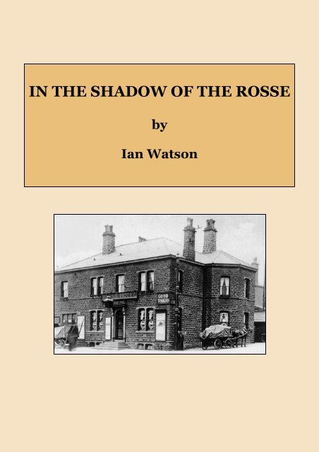
At the time it was built, the new pub, ‘The Rosse Hotel’, would have looked quite isolated,<br />
as there was nothing on this south side of the road for a long way in either direction.<br />
It was, however, just across the road from ‘dry’ Saltaire, and so had a ready<br />
made ‘clientele’ on the doorstep. The new landlord could also expect a regular increase<br />
in customers from the new houses that would be built by his brothers in the near future.<br />
During the same period that the ‘Rosse’ was being built, another building was going<br />
up at the opposite end of the site. In 1870, the Countess of Rosse sold 853 sq yds of<br />
land to a Jabez Copley, a resident of Saltaire, who proceeded to build a grocers shop on<br />
part of the plot [F & 6]. He had earlier been given planning permission for quite a large<br />
building project within these fields, which had included many houses and shops, but<br />
they were never built, and this one shop was the only work he did on the site.<br />
8 Information given by Mrs Gill 2, Moorhead Lane (1987)<br />
9 Davison D.H. (1989) Impressions of an Irish Countess, The Birr Scientific Heritage Foundation, Birr,<br />
Ireland<br />
10 Gill G.J. The Ten Hour Parson quoted in Hammond J.L. & B (1911) (Reprint 1987) The<br />
Town Labourer 1760-1832, Allen Sutton Publishing<br />
6
CHAPTER THREE<br />
Prior to fairly recent times, the vast majority of houses occupied by the working classes,<br />
as well as many occupied by the lower middle classes, were rented rather than being<br />
owned outright. There was, however, one way for working class people of the nineteenth<br />
century to buy their own homes and that was through the creation of a building<br />
club. 11<br />
In September 1871, the Countess of Rosse sold 2,254 square yards of land, between<br />
Queen’s Road and Moorhead Lane, to a group of men who called themselves ‘The Saltaire<br />
Building Club’ [B]. The deed of sale was signed by the representatives of the club:<br />
Amos Booth, a bookkeeper of Saltaire and Christopher Althorp, a foreman. They in turn<br />
sold the plots of land to the individual members of the club, who then took out mortgages<br />
with the Bradford Equitable Building Society. Nine through terraced houses<br />
were built for the new owners, among whom were 3 overlookers, 2 woolsorters, and a<br />
gardener. The new row, with a nice outlook over to <strong>Shipley</strong> Glen, was, appropriately,<br />
called Glenview Terrace. The houses were originally built with outside privies (ash<br />
pitts ?) but in 1883 they were converted to W.C’s.<br />
A few years later, in 1874, the Countess of Rosse sold 10,240 sq yds of land, running<br />
from the middle of Queen’s Road to the middle of Oastler Road, to Rhodes Bros. [D].<br />
The first houses - c.1874<br />
The visual evidence of surviving housing projects from the late nineteenth and early<br />
twentieth centuries, along with the records of the West Riding Registry of Deeds, seems<br />
to suggest that it was the normal practice during this period for speculative builders to<br />
develop their sites piecemeal. The tradition seems to have been to borrow money from a<br />
private individual or a building society, and then build a short row of houses. They<br />
would then be sold, and the process would start all over again with another small block being<br />
developed. It would also appear to have been normal in such small-scale developments<br />
for the various blocks to be of different sizes and designs. The Oastler-Ferrand<br />
Road development is a classic example of this.<br />
7
The first block of houses to be built on the site was a set of 9 small, cottage-type, backto-back<br />
houses. Each house was fronted by a small yard which housed a privy and a<br />
coalhouse. In addition, there were two shops fronting onto Bradford and Keighley Road<br />
[8]. The shop at the junction with Oastler Road was opened as a grocers shop and offlicense,<br />
and continued in this trade, through various owners and tenants, right up<br />
until the demolition of the site 95 years later.<br />
This block was part of the Rhodes brother’s property that came under the control<br />
of their trustees at the time of the firms bankruptcy in 1882. The trustees then appear<br />
to have mortgaged this property to the trustees of another <strong>Shipley</strong> builder, William<br />
Ives.<br />
1877<br />
The 7 houses and 2 shops were then sold, by the Ives Trustees, to the trustees of the<br />
Baildon Branch of the Ancient Order of Foresters, for £1605 in 1886. The Foresters<br />
held onto the property until 1920, when they sold the entire block to James Edgar Kay,<br />
who ran a small plumbing business from 54 Bingley Road, which was the shop at the<br />
corner of Ferrand Road and Bingley Road. He and his heirs continued to own this<br />
property until the compulsory purchase of the site in 1967.<br />
1876 saw a further batch of 7 houses built in Oastler and Ferrand Roads [11].<br />
Planning permission was also given for another block of 6 houses adjoining [23], but<br />
these were not built until 1897. This new block, which was built with the aid of a<br />
mortgage taken out by Mrs Rhodes, was divided from the earlier block by the line of<br />
the Barden Conduit. These houses were also much larger than the earlier block below<br />
them. Due to the lie of the land at this spot, the living rooms were raised well above<br />
street level, and the entrance to the houses was via a flight of steps. This allowed<br />
enough space underneath the main room for a large cellar-kitchen. In 1890 Mrs Rhodes<br />
sold this block to Henry and Hannah Moore of Keighley. They in turn sold it to the<br />
Misses Brown of Keighley in 1895. In 1915 the block was sold to James E. Sutcliffe, a<br />
house furnisher of Leeds Road, Windhill, for £1150.<br />
Planning permission for the Queen’s Road-Ferrand Road site was also given in 1874. A<br />
long block of 34 back-to-back houses was then built by Rhodes [9]. Two larger houses, No’s<br />
8
35 Ferrand Road and 18 Queen’s Road, were added on to the end of this row in 1875<br />
[12]. They were bought by Mr. Thomas Akam, a Bradford stuff merchant in 1877.<br />
He paid for them with a mortgage of £600 taken out with a private mortgagee, Mr.<br />
Jonathan Wilkinson.<br />
In November 1875, the Rhodes brothers decided, for some unknown reason, to split up<br />
their business partnership in this particular project, and a Deed of Partition was drawn<br />
up. 12 Thomas and William Rhodes took 7,270 sq yds out of the 10,240 sq yds which had<br />
been sold to the brothers by the Countess of Rosse in 1874. This being the northern end<br />
of the Queen’s/Ferrand Road plot, and from the east side of Ferrand Road to the west<br />
side of Oastler Road [8,11,12,15,23,24,25].<br />
Charles Edwin Rhodes took the remaining 2,969 sq yds, between Queen’s Road and<br />
Ferrand Road, which was occupied by the block of 32 back-to-backs which the firm had<br />
only recently built [9]. In 1876, Charles Edwin sold all these houses to the Bradford<br />
Third Equitable Benefit Building Society, who then rented the houses out. In 1890 the<br />
Building Society sold the top four houses in the block to Mr. William Wade, a spinning<br />
overlooker of 60, Titus Street, Saltaire [9a]. In 1893 they sold the remaining 30<br />
houses to Mr. John LaPage, a yarn agent of Moorhead Villas. He bought them with<br />
a £3200 mortgage.<br />
After his death the Trustees of Mr. LaPage sold the houses to C.F. Taylor’s Ltd. for<br />
£4750. Sometime after 1910, the seventeen houses in Ferrand Road were re-numbered.<br />
No. 3, at the north end became No. 15, and the top house changed from No. 35 to No.<br />
49.<br />
It was around this same time that the Local Board gave permission for the firm of<br />
Rhodes Bros. to build a Roller-skating rink. The rink is described in the planning<br />
records as, “a temporary wooden structure between Oastler and Ashley Roads to be<br />
known as the <strong>Shipley</strong> and Saltaire Skating Rink”. In fact the rink was constructed on the<br />
site of a former quarry opposite the top of Victoria Road. It was opened on the 1st July<br />
1876 as the ‘Victoria Park Skating Rink’, and was managed by the Rhodes’ brother-inlaw,<br />
John Burgess. 13 At the time of writing, there are no details as to how long this rink<br />
operated, but it would appear that it was not there for very long, as it does not appear<br />
on any map of the period.<br />
In 1877, Thomas and William Rhodes bought the remaining undeveloped part of the<br />
site from the Countess of Rosse. It consisted of an area of 10,770 sq yds, running<br />
from the centre of Oastler Road, eastward to the old field boundaries [E]. The brothers<br />
immediately sold off one small section in Ashley Road to a firm of quarry owners called<br />
John and William Kay [13].<br />
The Kays took out a mortgage with the Bradford 2nd Equitable Benefit Building Society<br />
and obtained permission from the Local Board to build 3 cottages and a stable in<br />
Ashley Road; another house was added to the block sometime later. In 1891 another<br />
four houses were built on the site of the old stables, and separated from the first block<br />
by a passage. In 1906 these eight houses were bought for £800 by Mary Hannah<br />
Brooksbank, the wife of Mr Albert Brooksbank. These houses, like the block adjoining,<br />
[14] and those opposite, [17] shared a lavatory with the house behind them. This<br />
required those occupiers of the houses fronting the street to walk through the passage,<br />
which was made between every two houses along the road, every time they required the<br />
lavatory. Such houses were known as ’tunnel backs’.<br />
9
The Rhodes’ firm received permission for another block of 8 back-to backs to be built in<br />
Ashley Road in 1878 [14]. This was on a plot abutting onto the Kay’s property [13].<br />
These houses, along with some properties in Bromley Road and Otley Road, which<br />
they owned, were mortgaged to Dr. John Terry, a Surgeon of Bradford. A second mortgage<br />
was then taken out to James Robert Singleton a Bradford timber merchant. The<br />
bankruptcy of the brothers, in 1882, [see below] was probably the reason for them failing<br />
to repay the mortgage, because in 1896 Mr Singleton sold these houses, along<br />
with others in Bromley Road, to Ferguson Marshall Jowett, formerly the landlord of<br />
the Junction Inn, <strong>Shipley</strong>. In 1902 Mr Jowett bought the other mortgage from Dr.<br />
Terry. Mr Jowett himself then took out a mortgage on all this property for £2000, repayable<br />
at £4 5s % per annum. He died in 1919 and the heirs of his estate sold the<br />
houses in Ashley Road to Edith Clough of Ivy Grove for £1000.<br />
In 1877 permission was given to the Rhodes firm for the erection of a temporary<br />
wooden building on Bingley Road, for the use of the Bradford Coffee Tavern. The<br />
idea behind the Coffee Taverns was to provide a non-alcoholic drinking establishment<br />
as an alternative to the public house; and was part of the on-going campaign, during this<br />
period, to encourage people to give up the ‘demon drink’. The precise location of this<br />
building is not yet known, as the Coffee Tavern does not appear in any of the trade<br />
directories of that time. However, if the tavern ever opened, it was probably at the junction<br />
of Ferrand and Bingley Roads, as there was a wooden building on this site around<br />
about this date.<br />
It would appear that the dispute of 1875, which had cause the break-up of the family<br />
business, worsened over the years. In July 1881, William and Murgatroyd Rhodes were<br />
charged with an assault on a bailiff, Edward Frost, who was attempting to retrieve<br />
goods from Murgatroyd, on behalf of their brother, Thomas. Thomas’s wife, Elizabeth<br />
Ann, was also assaulted in the mêlée. The full details of the family quarrel were not<br />
disclosed in court, but William was fined 20 shillings, i.e. £1. 14<br />
In spite of their problems, the firm of Rhodes Brothers Ltd. remained very active<br />
as building contractors throughout this period. Among their other <strong>Shipley</strong> projects<br />
were houses in Bromley Road (1877); Dallam Road (1881); and the Salvation<br />
Army Citadel in Rhodes Place (1893). They also had several contracts from the county authorities,<br />
for building work on various schools throughout the West Riding; and from<br />
railway companies for various station buildings. 15<br />
In the 1881 census, Thomas and Elizabeth Ann Rhodes are shown to be living at 11,<br />
Oastler Road, which was the largest house within this block [11]. The census also shows<br />
Thomas at this time to be a, ‘Contractor - employing 60 men and 20 boys’. The Rhodes’<br />
seem to have moved house quite often. Over the years, they lived in many of the houses<br />
that they had built within this area. At the time of his death, in 1917, Thomas was residing<br />
at No. 4 Robinson Street [27], which backed onto the houses facing Ashley Road.<br />
In the early years of this building project, the Rhodes firm had their base at the northern<br />
end of the Queen’s Rd/Ferrand Rd site, fronting Bingley Road [15]. The evidence<br />
for this comes from a threatened prosecution from the Local Board who were reacting<br />
to a complaint about the amount of dirty smoke coming from their engine chimney (a<br />
steam crane?) in their builders yard. 16 But later, in 1877, they moved to new premises,<br />
in a worked-out quarry at the top of Oastler Road, which would be their main base for<br />
the next forty years [21]. They then sold the vacated site to Mr John Burgess, their<br />
10
other-in-law, who in turn, sold it to Mr Joseph Greenwood of Oxenhope. Two<br />
houses were built adjoining the existing row [15a], while the rest of the site was kept for<br />
stabling and workshops. Later on these buildings would be used by a joiner and a blacksmith,<br />
while in the latter years they were used as garages for various local firms.<br />
In 1886 Mr Greenwood sold this plot to Mr Benjamin Hargreaves, a Grocer and Confectioner,<br />
who built a row of wooden shops facing onto the main road. The early occupiers<br />
of these shops included a photographer and a greengrocer. In 1921, these shops,<br />
no’s 58-62 Bingley Road, were bought by James E. Kay, the founder of the firm of<br />
plumbers and electricians, in partnership with a Mr Walter Minakin. Miss Edith<br />
Minakin, possibly his sister, ran the sweetshop until her death. In 1944, Mr Percy<br />
Warne leased the shop from Mr Minakin and it became part of the ‘Anne’s of Saltaire’<br />
chain of shops.<br />
This shop is the last remaining example of a range of wooden shops which had been constructed<br />
on Bingley Road during the early years. The shop lies adjacent to the Barden<br />
Conduit, and the writer of this study has been given to understand that, in the event of<br />
an emergency, the water authorities have the right to demolish the shop at only a few<br />
hours notice in order to get to the pipes.<br />
The Moorhead Lane Tramshed<br />
The land at the top of Oastler Road [21], on which the brothers had built their new<br />
workshops in 1877, had been mortgaged, by Mrs Rhodes to the Bradford Old Bank<br />
as security for her husbands debts. In 1907 this bank got into financial difficulties<br />
and ceased trading. Their affairs, which included the Rhodes mortgage, were taken<br />
over by the Counties Bank. However, it was only a few years later when this bank itself<br />
was wound up, and, in 1916, the deeds and mortgages passed to their liquidators, The<br />
United Counties Bank.<br />
The new mortgagees allowed Mrs Rhodes, in partnership with a timber merchant called<br />
Denby Drake, to pay off the mortgage, and Mr Drake ran the workshops as the Victory<br />
Saw Mills. The business didn’t thrive and by 1923 the firm was under the control of the<br />
Receivers. The workshops were then bought by William Stephenson, a joiner who<br />
had been running his business from a shop that he had built in Saltaire Road just be-<br />
11
hind the Salts Hospital. This building was later owned by Jefferies Motorcycles, and it is<br />
still a motorcycle showroom to this day. The firm of Stephenson’s, operating as joiners<br />
and undertakers, remained on this Oastler Road site until the demolition in the 1960s.<br />
In 1881, a tramway promoter from Southport, by the name of Joseph Speight, applied<br />
to the <strong>Shipley</strong> Local Board for permission to build and run a horse-drawn tram service<br />
along Saltaire Road. 17 The tramline was to start by the Fox and Hounds public house in<br />
Commercial Street, and terminate on the Bradford to Keighley Road, just passed the<br />
present roundabout. It was also decided to build a tramshed nearby to house the cars<br />
and horses. This was built on a plot of land a little way up Moorhead Lane [4]. The<br />
buildings consisted of a shed for four cars, and stables for twenty horses. A cottage was<br />
also built on the site.<br />
Work started on the new line in March 1882, but a row with the labour force over<br />
hours and conditions caused an immediate strike. The men had been contracted for a<br />
5½ day week, from 7.00 am to 5.30 pm weekdays, and until 12 noon on Saturday. The<br />
wages for the work was to be 3 shillings (15 pence) per hour. The management wanted<br />
the men to start an hour earlier in the morning and work until 12.30 pm on Saturday,<br />
as well as providing their own shovels. However, the dispute was soon settled, and<br />
work was resumed. The line opened on 2nd August 1882, though it was not a success.<br />
Consequently, in 1884, it was sold to a Richard Maurice Jones from Liverpool,<br />
described in early deeds as a Ironmonger, but later as a Tramway Proprietor. In<br />
1885 the line was taken over by the Bradford and District Steam Tramway Company.<br />
The new company had great difficulty in running the line and had to be given a<br />
three months extension by the <strong>Shipley</strong> Local board, to try and make it viable. They<br />
continued to run the line for the next few years, though for a period of three months in<br />
1888 the trams stopped running again. 18<br />
By 1891 the Local Board was negotiating with this company to try and stop them closing<br />
the line down. Finally, in 1893, the <strong>Shipley</strong> Local Board bought the line and the<br />
Moorhead Lane Depot for £1000 and operated it themselves for a short time, before<br />
selling out to the Bradford Tramways and Omnibus Company. In 1906, following the<br />
building of a new, large, tramshed, just across the road from the Rosse Hotel in 1904,<br />
the old shed became a garage run by the Rosse Motor Car & Cycle Company. This firm<br />
went into liquidation in 1909 and the building was taken over by the Thornton Engineering<br />
Company. Since that time, this building has changed hands several times,<br />
though nearly always for the purposes of light engineering products.<br />
11 Caffyn, L. (1986) Workers’ Housing in West Yorkshire 1750-1920. RCHM, London HMSO<br />
12 WRRD - 1875 735 694 764 : Deed of partition for Rhodes Brothers Ltd.<br />
13 WYAS Bradford : <strong>Shipley</strong> Local Board Building Plan No. 581 1876; plus The <strong>Shipley</strong> & Saltaire<br />
Times: July<br />
1876. :<br />
The London Gazette of 21st March 1879 shows that the partnership of Edward Cordingley, John Thomas<br />
Peacock and Thomas Rhodes, carrying on a business known as the ‘<strong>Shipley</strong> and Saltaire Skating<br />
Rink Company’ was dissolved by mutual consent.<br />
14 The <strong>Shipley</strong> & Saltaire Times : 9 th July 1881<br />
15 Pike W.T. (1897) A Descriptive Account of Bradford and <strong>Shipley</strong> Illustrated<br />
16 WYAS Bradford - SLBH Minutes 1 st May 1877<br />
17 WYAS Bradford: BMT/SH/6/1<br />
18 <strong>Shipley</strong> and Saltaire Times : March 4th 1882 & August 5th 1882<br />
& Coates, D.M.(1984) Bradford City Tramways 1882-1950, Wyvern Publications<br />
12
CHAPTER FOUR<br />
In early 1882 the firm of Rhodes Brothers appears to have got into financial difficulties.<br />
At the time there was a depression in the general economy, and, locally, a reduction in<br />
house prices and rentals, due to too many houses coming onto the market. 19 As a result,<br />
many speculative builders, such as the Rhodes’ firm, found that their returns were<br />
not enough to cover their mortgages and other debts, and their creditors moved in.<br />
In March of that year, at a hearing in the Bradford County Court, a special resolution<br />
was passed, under the Bankruptcy Act. It called for the liquidation of the assets of<br />
the firm of ‘Rhodes Brothers, operating as builders, quarry owners and stone merchants<br />
at Oastler Road and the Midland Station, <strong>Shipley</strong>’. 20<br />
The court appointed a charted accountant, James Clough Wright, to manage the affairs<br />
of the firm. At a meeting of the creditors, called at Leuchers Restaurant in Darley<br />
Street, Bradford, on the 22nd March 1882, it was disclosed that the liabilities of the<br />
firm was £1922 6s 7d, while the assets were £535. The creditors resolved to liquidate<br />
the company. The assets of the firm, which included the land between Queen’s Road<br />
and Ashley Road, as well as land in Bromley Road, Hirstwood and Rosse Street, were<br />
handed over to a group of trustees. 21 All their properties were then, apparently, taken<br />
over by the Bradford Commercial Joint Stock Banking Company who administered<br />
them.<br />
In spite of the bankruptcy and liquidation, the firm of Rhodes Brothers appear to have<br />
continued in business. Though, from this time on, all records relating to the firm are in<br />
the name of Elizabeth Ann Rhodes, the wife of Thomas. It can be assumed that this was<br />
a technicality, as the records show that Thomas, while, presumably, not able to front his<br />
business legally, certainly continued to operate as a builder after this time.<br />
It was also in 1882 that the <strong>Shipley</strong> Local Board changed the names of several of the<br />
roads in <strong>Shipley</strong>. Among them was the Bradford and Keighley Road, which was divided<br />
into two sections. That part to the east of the ‘Ring O’ Bells’ was re-named, Bradford<br />
Road; while the road to the west of the pub, which included the section running<br />
past our site, was to be called, Bingley Road.<br />
In 1883, a major health scare, in the form of cholera, struck <strong>Shipley</strong> and the surrounding<br />
area. As a result, the authorities in <strong>Shipley</strong> started to take a renewed interest in the<br />
general standard of health in the town. An urgent survey was carried out by the Medical<br />
Officer of Health into the state of the town’s sanitation facilities. The resulting recommendations<br />
were then presented to the <strong>Shipley</strong> Board. Stricter enforcement of the rules<br />
governing the standards and maintenance of ash-pits and privies followed. One of the<br />
initiatives to come out of this scare was to post warning notices about the danger of<br />
disease on all ash-pit doors in the town. There was also a crackdown on breaches of basic<br />
public health standards.<br />
Among the first to come to the attention of the authorities, following the introduction<br />
of this new hard line, was the Bradford Third Equitable Building Society. In June<br />
1884 the <strong>Shipley</strong> Local Board ordered the society to provide traps, and repair defective<br />
drainage in their houses in Queen’s and Ferrand Roads. A month later while the town<br />
was in the middle of a drought they were told to stop the waste of water in the street. In<br />
13
December of the same year they were told to keep their w.c’s in good repair, and when<br />
the repairs were not done within the specified time they were threatened with prosecution.<br />
22<br />
All the evidence above suggests that, in order to maintain standards, the local authorities<br />
had to keep a continual check on the housing situation throughout the town. Even<br />
when it involved, what might be assumed to have been, a respectable business such<br />
as a building society.<br />
In 1885, the Bradford Commercial Joint Stock Banking Company sold a plot of land at<br />
the junction of Ashley and Bingley Roads to the Windhill Independent Co-operative Society<br />
[16]. Permission was then given by the Local Board for the building of two shops<br />
and three houses on the site. The Ordnance Survey map of 1889, shows that the three<br />
houses, two in Ashley Road, and one fronting onto Bingley Road, were built first. Some<br />
time later, the Bingley Road house was converted into a shop, and an additional building<br />
was added to its side. The whole block then consisted of: a butchers, a grocers and a<br />
drapers. They survived as such until the demolition in the 1960s, albeit with the grocer’s<br />
having been converted into one of the new self-service ‘supermarkets’, not too<br />
long before the demolition.<br />
Over the next few years things seem to have improved for the Rhodes firm. Elizabeth<br />
Ann Rhodes started to buy back much of the land taken under the control of the Bradford<br />
Commercial Bank at the time of the bankruptcy. In January 1890 Mrs Rhodes, operating<br />
as Rhodes Brothers, received permission to build a block of 8 back-to-back<br />
houses in Ashley Road, just behind the Co-op [17]. A year later the firm built a second<br />
block of 7 houses adjoining [18]. The houses were financed by a mortgage for<br />
£1000 taken out with Mr Robinson Bramley of Outwood Hall, Wakefield.<br />
These houses were different from earlier ones that the firm had built, in that the ‘back’<br />
houses faced into an enclosed yard. Prior to this time all the houses constructed on this<br />
site had faced out onto their own streets, with the majority of the houses having their<br />
own yard and lavatory. In this particular case, each pair of houses, front and back, had to<br />
share a lavatory, as, indeed, did those who lived on the opposite side of Ashley Road. Presumably,<br />
these houses were designed for tenants who required a lower rental accommodation<br />
than those who took the earlier houses [see below].<br />
The lavatory blocks were situated within the enclosed yard, and were sited only a few<br />
feet away from the houses they were to serve. The lavatories themselves were below<br />
ground level and were accessed by a flight of steps.<br />
On completion, in 1891, both blocks of houses were sold to Mary Hannah Brooksbank,<br />
the wife of Alfred Brooksbank of <strong>Shipley</strong>. Mrs Brooksbanks sold all her Ashley Road<br />
properties to Sir Titus Salt Bart and Sons Ltd. in 1920, at a time when several textile<br />
mills were expanding their housing interests. Elizabeth Ann Rhodes also sold another<br />
small block, [29], to the Saltaire firm at the same time.<br />
Following her sale to Mrs Brooksbank, Elizabeth Ann Rhodes bought another plot<br />
from the Bradford Commercial Joint Stock Bank, an area of 1600 sq yds, bounded by Oastler<br />
and Bingley Roads [19,20]. A row of five wooden shops were erected on that part<br />
of the site fronting Bingley Road [19]. Among the first occupants of these shops was a<br />
confectioner, a hairdresser and a plumber. There was also a small stable at the Oastler<br />
Road end. Behind these shops were the remains of an old quarry. This land was never<br />
developed and remained as waste land until the time of the modern re-development.<br />
14
Following her purchase, Mrs Rhodes took out a mortgage in order to build a block<br />
of 8 back-to-back houses on the southern part of the site [20]. This block included 4<br />
houses fronting onto Oastler Road and 5 houses facing into a communal back yard.<br />
The Co-op Buildings<br />
These houses faced across the yard to the ‘back’ houses in Ashley Road [17,18]. The<br />
houses in this block, like the ones opposite them had shared toilets. The one exception<br />
to this was No. 10 Oastler Road, which, due to the angle of the design, was larger<br />
than the others, and being the odd one out, had its own private, outside, lavatory. All<br />
these ‘back’ houses had a small garden plot and there was a reasonable amount of space<br />
between the houses and the wall dividing the Oastler Road houses from the Ashley<br />
Road ones, for such things as hanging out the washing.<br />
These houses were sold by Mrs Rhodes in 1897. They were bought by a Mr Anderson<br />
Rhodes ( no relation) who ran the butchers shop at the corner of Katherine Street in<br />
Saltaire. The sale also included the vacant land at the bottom of Oastler Road and the<br />
wooden shops that faced onto Bingley Road. At the same time, Anderson Rhodes also<br />
bought the small block of houses in Queen’s Road situated just behind the Rosse Hotel [3].<br />
When he died in 1909, Anderson Rhodes left all his property to his two sons and one<br />
daughter. When they decided to sell their Oastler Road property in 1925, the wooden<br />
shops, and the spare land behind [19], went to the Windhill Co-operative Society, who<br />
had the buildings next door; while the 9 houses were sold to a relative, Mr Fred Shuttleworth<br />
of Sherwood Grove. These houses later passed to another member of the family, a<br />
Mrs Lillian Shepherd. When she sold No. 4 Oastler Road to its occupier Mr Dennis<br />
Crabtree, in 1947, the deed of sale included a condition allowing him to continue sharing<br />
the outside toilet with the house at his back, No. 8.<br />
In 1952, the other 8 houses were sold to Mrs Annie Sanderson of Lidget Green for<br />
£1500. Over the next few years she sold No’s 2, 8 and 12 to individual occupiers. But due to<br />
the inability of the remaining tenants to buy their homes, the other 5 houses -<br />
6,10,14,16,18, were kept as rented property until the council bought them in 1969.<br />
The final development on the Ferrand and Oastler Roads plot, consisted of 7 houses in<br />
15
each street. They were constructed in 1896 [23,24,25]. The proceeds from the sale of<br />
these properties went to paying off the debts owing to the Yorkshire Banking Company.<br />
Block [23] was sold to Mr Samuel Sheard of Earl Street, who bought them with a<br />
mortgage of £780. These houses passed through several owners over the years, but by<br />
the beginning of the second world war they were all owned by their individual occupiers.<br />
Block [24] was bought by Samuel Whittingham, an overlooker. He sold No. 27 Oastler<br />
Road and No. 28 Ferrand Road before the turn of the century, but still had the other<br />
four houses at the time of his death in 1942. The last two houses in the block [25] were<br />
sold to a Lily Grange of Westcliffe Road, who sold them to James E. Kay, the plumber,<br />
in 1910.<br />
All of the above, can be taken as evidence of the widespread habit of relatively ordinary<br />
people investing in property, albeit on a fairly small scale, at the turn of the nineteenth<br />
and twentieth centuries.<br />
By the late 1880’s the population of <strong>Shipley</strong> had risen quite considerably. One particular<br />
effect of this increase was felt in the parish church of St. Paul’s in Kirkgate. The<br />
church could only seat 1,200 people, and was unable to provide for the growing number of<br />
potential new worshipers in the town. Sometime around 1888, a group was formed to organise<br />
the funding for a new Anglican church to cater for the overflow.<br />
Things moved quite slowly for a few years, until in 1891, when Mr Joseph Poole, of<br />
Moorhead Villas, left £500 in his will towards the cost of building the new church.<br />
A short time later a further gift of £500, from Mr George Knowles of Hollin Hall, at<br />
the top of Moorhead Lane, was given to be used for the purchase of a suitable site. The<br />
trustees approached the Earl of Rosse about a plot of land in Moorhead Lane. He<br />
agreed to sell the land for £600. The trustees only had the original £500, but after some<br />
negotiation the Earl decided to give the trustees £100 himself. In May 1892 the trustees<br />
purchased the plot of 3320 sq yds [C-22]. They then started the process of raising more<br />
funds in order to start the actual building.<br />
The foundation stone of the Church Hall, the first building to go up on the site, was<br />
laid in 1893, and plans for the church itself were drawn up. It was to be named in honour<br />
of St. Peter, and the cost of building it was estimated at £6,000. It took considerable<br />
time to raise the money required and the foundation stone of the church was not<br />
laid until 1907. The new church was finally consecrated by the Bishop of Ripon in<br />
1909.<br />
The original 1904 architects drawing shows the vicarage attached to the church on the<br />
southwest corner, in what is now the car park. 23 For some reason this was not built.<br />
And, until the vicarage on the opposite side of Moorhead Lane to the church was purchased<br />
in 1923, the vicar lived at Highfield House, a little further up Moorhead Lane. 24<br />
19 Wilson, A.N.(2002) The Victorians, Hutchinson London & Bradford Weekly Telegraph, December<br />
1882<br />
20 Yorkshire Observor : 15 th March 1882<br />
21 Yorkshire Post : 22 nd March 1882<br />
22 WYAS Bradford - SLBH Minutes : June and November 1884<br />
23 WRRD : 1904 131 63<br />
24 Thompson, J.D. (1984) St. Peter’s <strong>Shipley</strong> - The First 75 years :<br />
16
CHAPTER FIVE<br />
In 1893, Elizabeth Ann Rhodes obtained another large section of the site, containing<br />
8,380 square yards, from the Bradford Commercial Joint Stock Bank. In order<br />
to pay for this she took out a mortgage with the Yorkshire Banking Company. The<br />
area involved covered the whole of the southern part of the site between Ashley and<br />
Ferrand Roads. Mrs Rhodes then leased off 3,460 square yards of this land at the top of<br />
Ashley Road to a stone-quarrying firm from Rawtenstall in Lancashire, called James &<br />
William Wylde [26,27,28,29,31,32,33,334]. The lease gave the Wyldes the right to take<br />
out the un-worked beds of stone on the site. Three years later, after they had left the<br />
area, Mrs Rhodes built some more houses to complete that eastern side of Ashley Road<br />
[26,27,28]. All were back-to-backs excepting the top house No. 8 [28] which was a<br />
through house. However, these last few houses were different from the other houses in<br />
Ashley Road, in that each had its own w.c. in its own yard.<br />
All of the "back" houses on the eastern side of Ashley Road had their frontage on a<br />
small lane which became known as Robinson Street - named after Mr Jesse Robinson<br />
who had bought four of these properties [27]. The two houses below them were<br />
bought by a milk-dealer called Albert Greaves, who, a few years later, sold them to the<br />
Windhill Co-operative Society. The top house, No. 8, was occupied by Mr and Mrs<br />
Thomas Rhodes themselves, until they sold it to a Mrs Stephenson in 1905.<br />
In 1896 Elizabeth Ann Rhodes bought a small strip of land 3 yds wide running across<br />
the southern edge of her property [35]. The reason for the purchase was to do with<br />
the width of the new road to be called Victoria Avenue. In 1898 Mrs Rhodes had applied<br />
to the Local Board for permission to build a row of houses on the proposed new<br />
road, but it was turned down as the Board did not like the design. However, later plans<br />
must have been acceptable, as over a period of the next few years, 1900-1904, permission<br />
was given for the building of various sections of this row of through terraced<br />
houses. Each section being separately financed with a mortgage from a variety of Building<br />
Societies and private investors.<br />
Victoria Avenue was built on a fairly steep slope. As a result the front room, facing<br />
onto the Avenue, was at ground level, while the same floor at the back was one floor<br />
above ground level. Also, some of the houses in the row were built with a small extension<br />
at the rear, making them much larger inside than they would otherwise be.<br />
The first houses to be built in Victoria Avenue, No’s 2 to 12, were sold, by Elizabeth<br />
Ann Rhodes, to Emily Bottomley in 1904. They passed into other hands a few years<br />
later. Then, in the early 1920s they were sold to their individual owner-occupiers [30].<br />
The next section. No’s 14 to 20 were sold in 1905 to Mr Anthony Gadie, of the Gower<br />
Trust, who sold them in 1907 to Dr. Arthur Hawkyard a Surgeon of Leeds [31].<br />
Most of the other houses, No’s 22 to 32 were sold as they were built to individuals.<br />
Except for No’s 26 and 28, which were bought by Ernest and Fanny Rhodes, the son<br />
and daughter-in-law of Thomas and Elizabeth Ann. Ernest was still living at No. 26<br />
during the 1940s [33].<br />
In 1908 Thomas and Elizabeth Ann Rhodes took out a private mortgage with a Mr<br />
John Speak, on No’s 22, 24, 30, 32 Victoria Avenue [32,34]. Mr Speak died in 1918 and<br />
17
the outstanding debt was bought. from his executors, by a Major John Speak Elwiss of<br />
the Royal Horse Artillery. In 1929 Major Elwiss was forced to sue, the by then widowed<br />
Mrs Rhodes, for repayment of the outstanding loan of £758 7s 2d, which she<br />
failed to do. The High Court ordered the loan to be repaid by a given date. When this<br />
was not done the court ruled that Mrs Rhodes had forfeited her rights to the properties<br />
and they were ordered to be handed over to Major Elwiss. In fact, the houses in question<br />
had already been sold to their occupiers by this time.<br />
In 1906 a small group of four houses was built at the top of Ashley Road [29]. They<br />
were quite unique, in that the shape of the houses had to fit into a rather unusual angular<br />
plot. The houses were of the through type, but, due to the shape of the plot, the front<br />
and back rooms were not in line with each other, but slightly off side. The angular<br />
shapes of these houses, and many of the other gable-end houses on the site, was due to<br />
them being on the edge of the Barden Conduit, which ran diagonally across the site, and<br />
over which building was not allowed.<br />
The opening of St Peter’s church in 1909 [see above], marked the end of the development<br />
stage of this site, a process that had begun back in 1869. All the available plots<br />
had been built on, and, no more could be done.<br />
1906<br />
This mini-village with its shops, pub and church, small industrial premises, and<br />
a mixture of house types had taken 40 years to complete and it was to survive more or<br />
less intact for the next 60 years.<br />
All of the houses in Oastler Road, and most of the houses in the other roads within<br />
this site, were back-to-backs, though they were a mixture of types and sizes. In all,<br />
there were a total of 112 back-to-back houses constructed within the four roads, and 32<br />
through houses.<br />
The houses were a mixture of one, two and even three bedroom types. There was<br />
also a large attic, used either for storage or as an extra bedroom for those families with<br />
several children. Most of the back-to-backs faced out onto the street, and had their own<br />
small walled-yards. The majority of these houses had their own lavatories and a coalhouse<br />
in the yard. The house door led straight into the main room of the house. The<br />
18
main feature of this room was a range style fireplace, i.e. a coal fire, with an oven built<br />
into the side for cooking. The limited space within the oven, meant that, in many cases,<br />
vegetables had to be cooked in a pan balanced on the edge of the fire-grate. It also<br />
meant that the fire had to be lit even on hot days so that the occupants could cook.<br />
Those houses that were in the middle of the blocks had their ‘kitchen sinks’ built<br />
into a cupboard at the side of the fireplace nearest to the window, to allow for the<br />
drainage outlet. Those houses with gable ends, or with side outlet to a passage had their<br />
sinks at the top of the cellar steps, or ‘cellar head’ - a small landing which usually also<br />
included a gas ring or gas cooker.<br />
The cellars consisted of a large main room, with a sink and a small brick-boiler for<br />
the laundry; a small pantry and, in certain houses, a ‘coil oil’. In these houses<br />
the coal was delivered through a grate either built into the wall side or into the top<br />
step just outside the house door.<br />
The cellars were also used as a, ‘bathroom’, though the bath would have been a<br />
portable zinc one. The hot water would be fed into the bath from a pipe leading<br />
from the fire-boiler, though after finishing the bath would have to be ‘ladled’ out by<br />
hand. In post-war years, gas water heaters were used for the purpose of heating the<br />
water.<br />
Lighting was by gas, at least until the late 1940’s, but this was only available in the<br />
main living room and the main cellar. There was no lighting of any kind upstairs, and,<br />
on dark nights, people went to bed by candlelight. The main bedroom had a fireplace<br />
in it, though the smaller ones did not. .<br />
Rents for the one bedroom houses in these streets in 1910 averaged around 4s 11d per<br />
week, while the two bedroom houses were around 5s 8d a week. The larger, through<br />
houses, in Glenview Terrace had a theoretical rent of 6s 6d per week, but seven out of<br />
the nine houses in this row were owner-occupied. All the houses in Victoria Avenue, on<br />
the other hand, were rented, and they brought in between 6s 11d and 7s 11d per<br />
week for their owners. As an example of an individual sale, a house in Ferrand Road<br />
in 1902 fetched £162. 25<br />
A survey of wages within the textile industry, compiled in 1906, shows that the average<br />
weekly wage for a man was 28s. 1d., and for women 15s. 5d. So the rents for these<br />
houses would be well within the limits of such people. 26<br />
Census returns, and rate books for the late 19th and the early 20th century, show that<br />
most of the wage earners who lived in these houses, were, for the most part, skilled<br />
craftsmen and textile workers as well as an assortment of shopkeepers, clerks, and a<br />
few self-employed. Even as late as 1901 there were quite a few quarry workers in<br />
these houses, showing that stone quarrying was still a common occupation in<br />
<strong>Shipley</strong> at this time. With the exception of the quarry workers, there was a similar class of<br />
person still occupying these houses in the 1960s<br />
n.b.The block of shops to the east of Robinson Street were also built by the Rhodes<br />
firm. They were then sold to Bradford businessman, Michael John Barry in 1900. But<br />
as they are outside the boundary of the, ‘three fields’, they are not part of this study.<br />
25 National Archives : The Valuation Office Survey-Finance (1909/10) Act : IR 58 & IR 134<br />
26 Askwith, G.R. (1906) Earnings and hours of labour of workpeople of the United Kingdom: I:<br />
textile trades in 1906: Board of Trade. Earnings and Hours Enquiry 1906<br />
19
CHAPTER SIX<br />
Victoria Avenue, like most of the other houses on the site, had been built on top of old<br />
stone- quarry workings. While this did not cause any problems for the other houses in<br />
the area, in the case of Victoria Avenue it was to lead to a disaster.<br />
During the early part of 1921, the owners and occupiers of the houses in the middle of<br />
the row noticed large cracks and general structural problems occurring in their homes.<br />
The occupiers of No’s 10 and 12, Mrs Green, and Mr and Mr Oddy, who had only<br />
bought their property in 1919, were soon forced to leave as the damage continued to<br />
get worse. At 4 am on Sunday 11th September 1921 the whole of the rear sections of<br />
No’s 10 and 12 collapsed into their respective yards.<br />
1920<br />
According to the Yorkshire Observer for the following day, the back parts of the<br />
houses collapsed, "with a tremendous noise like an earthquake". The lane running<br />
across the top of Oastler and Ashley Roads was completely blocked, and the heavy<br />
weight of the fallen masonry and wood broke the gas and water mains pipes in the<br />
ground below. A photograph in the same newspaper shows the rooms of the two houses<br />
exposed to the elements while the rubble of the old walls lies beneath them.<br />
The neighbours on either side of the collapsed houses had to move out, as a safety<br />
measure. But it was not long before some of them had problems of their own, as the<br />
damage spread to their properties. The family at No.8 were able to go back after a<br />
while, but those on the other side found that their homes had become uninhabitable.<br />
The owners of these properties tried to persuade <strong>Shipley</strong> Council to accept responsibility<br />
for the damaged houses. The council was not very keen, and the owners were<br />
told it was their own problem. After surveying the damage, the council ordered the<br />
owners to clear the site and make the area safe. However, later on, presumably after<br />
a certain amount of pressure, the council relented, and in May 1922 the council<br />
20
agreed to take on the task of clearing the site.<br />
They did this only on the condition that the owners gave the property to the council.<br />
This deal appears to have fallen through because in October 1923 the council took the<br />
owners to court. The owners were ordered to clear the site - which by this time also included<br />
the sculleries of No.14, and No.16, which were also in a state of collapse.<br />
The owners were told that if they did not proceed immediately the council would do<br />
the work themselves, and the owners would then be held responsible for the cost of the<br />
operation. The clearances would however, be subsidized by the sale of the salvaged<br />
material. In the event, by the time the council made the site safe, at the end of 1923,<br />
the sale of the stone etc. met the full cost of the clearance and it did not cost the owners<br />
anything.<br />
This was not the end of the story however, as No’s.14, 16, 18, 20 continued to deteriorate<br />
and were quickly abandoned. They remained standing but empty for many years.<br />
In 1935, the council examined them again and condemned them. The houses were<br />
bought by the council for just a few pounds and demolished.<br />
The houses that stand in Victoria Avenue today are still separated by the gap of the demolished<br />
houses. They have survived unscathed, but only just. In the early 1960s the occupiers<br />
of one of the houses woke up to find that their back yard had all but disappeared,<br />
down what appeared to be a bottomless pit. There have been no other incidents of this<br />
sort since then, but presumably it is quite possible that something of the kind could<br />
happen in the future.<br />
c.1940<br />
21
CHAPTER SEVEN<br />
Apart from Victoria Avenue, little happened, visually, within this area in the period between<br />
the wars. One exception, however, occurred in 1923, when J. E. Kay and Walter<br />
Minikin pulled down one of the wooden shops, at the junction of Bingley Road and Ferrand<br />
Road and put up a stone building in its place. It is possible, though not proven,<br />
that the demolished building was the one approved for use as a Coffee Tavern by the<br />
Local Board in 1887.<br />
The new building became a family butchers, which, for many years, was under the management<br />
of John Chell, who was a well known figure in <strong>Shipley</strong>, being a leading light<br />
in the Legion of Frontiersmen in the pre- and post-war years.<br />
The rooms immediately above the butcher’s shop were used for a variety of purposes<br />
over the years. During the 1950s, one set of rooms was used as a chocolate confectionary<br />
production department for Percy Warne’s, ‘Anne’s of Saltaire’; and another<br />
room was used by the Apostolic Church.<br />
The main changes that did occur in the inter-war years mainly related to the ownership<br />
of the houses. It appears to have become common practice after the end of World War<br />
I for the directors of the main textile mills in <strong>Shipley</strong> to expand their property portfolios<br />
in the town. In 1920, for example, Sir Titus Salt Bart. & Sons Ltd. bought virtually the<br />
whole of Ashley Road [13,17,18,29]; while, in the same year, C.F. Taylor’s, based in Otley<br />
Road, Baildon, bought 30 houses between Ferrand Road and Queen’s Road [9]. In 1927,<br />
C.F. Taylor’s sold all their houses to a business called The Aire Property Trust. While<br />
in October 1933, Salts sold the village of Saltaire, and all their other houses, including<br />
Ashley Road, and all those that they owned between Park Street and Thompson Street - a<br />
total of 964 houses - to The Bradford Property Trust for £164,500.<br />
The Bradford Property Trust had been founded in 1928 by Fred Gresswell, a Bradford<br />
estate agent, and Algernon Denham, a director of the Halifax Building Society. It was<br />
Gresswell who, in the early 1920s, had recognised how the problems of a low rental<br />
income, due to rent controls, and the high cost of repairs, due to post-war inflation,<br />
meant that many rented estates were no longer economically viable for their owners.<br />
Gresswell’s idea was to purchase such estates, sell the empty houses immediately, in<br />
order to realise some immediate return on his investment, and then persuade the<br />
sitting tenants to purchase their own homes, at a price below the market price, but at<br />
a level which gave Gresswell a small profit on each house. This was done using a double<br />
mortgage plan, which Gresswell had devised, which meant that the mortgage repayments<br />
were little more than the existing rent. 27<br />
By 1935 there were only 7 houses in Queen’s Road and 5 houses in Ferrand Road left<br />
in the portfolio of The Aire Property Trust, at which time they were transferred to a firm<br />
called The Rossefield Estate. They too started to sell more of these houses to their individual<br />
occupiers, and by 1942 the only houses still in their hands were No’s 2 & 7 Queen’s<br />
Road. However, there were still several small blocks of property throughout these four<br />
streets in the hands of private landlords, and many remained so until the demolitions.<br />
n.b. There appears to be little information available about the Aire Property Trust. However,<br />
it is known that both the Aire Property Trust and the offices of the Rossefield Estate<br />
were based at 19, Market Street, Bradford, in 1935.<br />
22
The middle years of the Second World War saw the start of several changes to this area.<br />
The first of these was the removal of the five wooden shops at the bottom of Oastler<br />
Road. Over the years they had been occupied by a variety of small businesses. In<br />
1898, for example, there had been a confectioner, a milliner, a hairdresser, a<br />
draper and a grocer; while in 1932, there had been a confectioner, a tripe dresser,<br />
a hairdresser and a watchmaker.<br />
The whole plot in which they stood [19] had been bought by the Windhill Cooperative<br />
Society in 1926. Presumably they had plans to develop the site at this time, as<br />
their deed of sale gave them specific permission to block up the windows in the gableends<br />
of the two houses in Oastler Road that overlooked the site. For some reason the<br />
planned building did not take place, and after the wooden shops were cleared away,<br />
sometime after 1942, the site remained vacant, with the exception of an advertisement<br />
hoarding, until the clearances of the 1960s.<br />
The late 1940s saw the introduction of electricity into these streets. For the first time<br />
every room in the house, from the attic to the cellars, had a light. The changeover from<br />
gas to electric also allowed people to buy the new electrical appliances, such as vacuum<br />
cleaners and electric irons, which were becoming more readily available after the restrictions<br />
of wartime.<br />
It also became possible for the occupiers to buy a mains radio for the first time.<br />
Prior to electrification, the only radio available in these houses came via a radio relay<br />
station, situated in Commercial Street, which fed a limited number of radio stations to a<br />
loudspeaker in the house, via a cable.<br />
A few years later came the electrification of the street lamps. One exception to this<br />
was the lamp in the middle of the enclosed area between Ashley and Oastler Roads.<br />
This lamp remained as a gas lamp for a long period after the introduction of electric<br />
street lights to the rest of the area, and the town’s lamplighter had to make a special<br />
journey to this lamp, and to the other few surviving ones in <strong>Shipley</strong>, every night in order<br />
to light it. When the last of the gas lamps in the town were finally removed in the early<br />
sixties, the old lamplighter, one of the last remnants of Victorian England, disappeared<br />
from the streets of <strong>Shipley</strong> for ever.<br />
However, despite the improvements within the area, the post-war years saw an<br />
increasing amount of dissatisfaction for many of the people who lived in these<br />
streets.<br />
The general restrictions and rent controls introduced during the war had reduced<br />
the profitability of rented houses, just at a time when these houses were of<br />
an age when they needed money spending on them. Even the abolition of such controls<br />
in the 1957 Rent Act, failed to change the attitude of the landlords. The result was<br />
that the rented houses within this area were not maintained as well as they should have<br />
been. For example, the houses were quite cold and draughty, due to the fact that the<br />
main door of the house opened straight into the main room. The tenants also felt that<br />
the rent which they were paying was not giving them value for money. The effect of this<br />
was a subject of persistent worry and complaint by the tenants. And both the landlords<br />
and the town council were to feel the wrath of the occupiers for several years before action<br />
was taken.<br />
On the other hand, the private house owners, of whom there were a growing number<br />
by the early 1960s, were usually prepared to spend money on improving their own<br />
23
properties. These improvements mainly consisted of the installation of a proper bathroom.<br />
This allowed them to abandon the old tin bath, and to give up once and for all,<br />
visits to the outside ‘lav’. Many also replaced the old range-type fireplace in the main<br />
room with a modern one. Though this was one modernisation that was carried out<br />
by tenants as well. Unfortunately, the expenditure involved in buying their homes<br />
and improving them was, in retrospect, a waste of money.<br />
The revival of the slum clearance programmes, that had been interrupted by the<br />
war, encouraged local authorities to replace as many of the older types of houses as<br />
they could with new houses and flats. This was helped by a range of government subsidies<br />
and special loans. While Windhill had a quite a large number of poor quality<br />
houses, and their replacement involved a large scale operation, within the old<br />
township of <strong>Shipley</strong> itself there were few, and they were quickly demolished. However,<br />
as the subsidies were still available to the council, it decided to continue with the<br />
work.<br />
In the early 1960s, <strong>Shipley</strong> council took the decision to condemned and demolished<br />
all back-to-back houses in the town regardless of their condition. As the houses within<br />
the four streets under discussion were, for the most part, of the better type of their kind,<br />
these streets were well down the list of priorities, and it was not until 1968-9 that the<br />
council got around to them.<br />
The new development - The first stage<br />
For some, the compulsory purchase of their homes brought many problems. People<br />
who had expected to live out their lives in their own private homes, usually bought<br />
after a certain amount of financial sacrifice, realised that they were going to become<br />
council tenants with a lifetime of rents to pay, and many were very resentful. 28 In addition,<br />
many of the private house owners felt that the amount of compensation offered to<br />
them was quite miserly. As a result, there were several instances of hard negotiations<br />
between the owners and the council before it was all settled. Even then, the compensation<br />
was very small.<br />
On the other hand, most of those who were tenants were delighted to be moving into a<br />
modern home with all the latest conveniences, such as central heating, hot running<br />
24
water and indoor plumbing. Quite a few of the people from this area went to the<br />
new Wycliffe Garden estate, off Saltaire Road.<br />
The contract for the demolition of the site was given to the contractor, Ogdens of Otley,<br />
and the work was completed in two stages.<br />
The re-developed site<br />
The first stage was the demolition of all the back-to-back houses in Ashley Road, Oastler<br />
Road , Ferrand Road and Queen’s Road. In their place arose two blocks of flats,<br />
Ferncliffe Court and Neville Place, both of which were specifically designed for older<br />
people. A smaller block, called Salts Court was added later.<br />
In the early 1970s, the final stages in the re-development of this site took place, with the<br />
demolition of the Bingley Road shops between Ashley Road and Ferrand Road. They<br />
were replaced with a terrace of new shops. Among them was a Cooperative store to<br />
replace the one that had been demolished.<br />
One result of the new developments was a reorganisation of the street names. During<br />
the course of the new building and landscaping, Oastler Road had disappeared completely.<br />
Only two small sections of Ashley Road and Ferrand Road survived, and they<br />
were linked together by a new road running behind the new shops. This new road were<br />
then renamed, Oastler Road, with the names of Ashley and Ferrand being lost. It can<br />
only be assumed that the officials responsible considered the name of Richard Oastler<br />
to be better known than either of his contemporaries.<br />
Looking at the area today, it is quite interesting to note that most of the earliest buildings<br />
on the site have survived. Glenview Terrace is still there, as is the Rosse Hotel.<br />
While at the opposite end of the site, the grocers shop at the bottom of Ferncliffe Road<br />
(previously Robinson Street) is also still there, though with a new roof and frontage<br />
to bring it into line with the modern shops.<br />
27 Brennan, J. (1978) History of the Bradford Property Trust 1928-1978, Whatmoughs, Bradford<br />
28 WYAS Bradford : <strong>Shipley</strong> Town Clerks Files 1946-1974<br />
25
CHAPTER EIGHT<br />
The creation of the <strong>Shipley</strong> Local Board of Health in 1853, and the powers specifically<br />
given to the Board to control all new developments in the town, meant that from that<br />
time on, all houses erected in <strong>Shipley</strong> had to be built to a certain minimum standard.<br />
The Local Board were also required to ensure that there was sufficient ventilation,<br />
within and around the houses; also that they were provided with a decent water supply<br />
and adequate sewerage facilities. The planning records of the <strong>Shipley</strong> Local<br />
Board, and the later Urban District Council, show that such powers were taken seriously,<br />
and many original plans were rejected for breaches of the bye-laws on these matters.<br />
Naturally, the standards and requirements for new buildings changed over the years,<br />
both in terms of local and national legislation. But the most controversial of all were the regulations<br />
regarding back-to-back house. Such houses had been a traditional way of providing<br />
homes for low paid industrial workers in many parts of the country throughout<br />
previous centuries. Though by the second half of the nineteenth century it had become<br />
accepted by most public health experts, and many local authorities, that living in such<br />
houses meant a poor standard of health for their occupiers.<br />
For example, a study by the Local Government Board into the health of residents of<br />
such houses, compared with those of through houses, suggested that there was an increase<br />
of between 15 and 20 percent in the death rates of the occupiers of back-tobacks.<br />
29 Although it could be argued that the people most likely to be living in such<br />
houses were among the poorest within any district, and that, as such, they would be<br />
more susceptible to debilitating illnesses anyway. Also, as George Sheeran has pointed<br />
out, opposition to such houses from the medical profession was based on the false medical<br />
theory of miasma. 30 Nevertheless, many local authorities in other parts of the country<br />
had outlawed such houses.<br />
However, <strong>Shipley</strong>, and many other towns within the West Riding continued to defend<br />
the right of builders to put up back-to-back houses despite national and<br />
county pressures to outlaw them. 31 Indeed, the pressure on the council from the<br />
developers was so great that they were sometimes coerced into breaking their own<br />
bye-laws. For example, during the course of 1892, <strong>Shipley</strong> council was in regular<br />
correspondence with the solicitor of the West Riding County Council and the<br />
Local Government Board in London, over the councils wish to pass plans for a new<br />
block of back-to-back houses in Belgrave Square which were said to be in contravention<br />
of such bye-laws. 32<br />
The evidence from Ordnance Survey maps show that a large number of homes<br />
built in <strong>Shipley</strong> during the last thirty years of the nineteenth century were back-tobacks.<br />
And this, despite the example from Saltaire, that through houses were a viable,<br />
and even a minimum requirement for decent housing - though there were even<br />
a few back-to-backs at the bottom end of Saltaire village, which survived until the<br />
1930s.<br />
The largest development of back-to-backs in <strong>Shipley</strong> can be seen to have been in the<br />
area bounded by St. Paul’s Road, Manor Road and Westcliffe Road, where over 450<br />
26
such houses were erected during the 1880s. While others were constructed in Wycliffe<br />
Road, Thompson Street and in a series of short cul-de-sacs off Saltaire Road.<br />
All of these developments were relatively close to the town centre, and the main mills.<br />
The better class of through houses that were being built in <strong>Shipley</strong> at the same time,<br />
were built a little further out in areas such as <strong>Shipley</strong> Fields.<br />
The failure of the county authorities to enforce a ban on the back-to-backs was<br />
one of the factors that encouraged the Liberal government of the day to increase its<br />
involvement in local authorities affairs through the 1909 Housing and Town Planning<br />
Act. One element of this new Act banned any local authority from approving any future<br />
schemes for back-to-back houses. However, houses that had been given planning<br />
permission before the act came into effect were allowed to be built, which meant that in<br />
places such as Leeds, they continued to be built well into the 1930s. 33<br />
29 Dara Mair, L.W. (1910) Back-to-Back houses. Relative Mortality in Through and Back-to-Back<br />
Houses in certain Towns in the West Riding of Yorkshire : Parliamentary Records :Cd 5314 xxxviii,<br />
893<br />
30 Sheeran, G. (1986) Back-to-back houses in Bradford, in Bradford Antiquary Vol. 2<br />
31 Gaskell, S. M. (1983) Building Control-National Statutes and the Local Community, British Association for<br />
Local History<br />
32 WYAS Bradford - SLBH minutes January to June 1892<br />
33 Leeds Civic Trust [Internet World Wide Web site ‘Back-to-back houses’ & note 2 above<br />
27
CONCLUSION<br />
While the building firm operating under the name of, ‘Rhodes Brothers’ appear to have<br />
had a great many contracts for public works within the county, as mentioned above,<br />
and built houses on many other sites in the district, they appear to have always operated<br />
on a relatively small scale. In that, they built a few houses, sold them, and then<br />
built a few more. This would appear to be evidence of the economically sensitive nature<br />
of the industry, which moved from boom to decline, if not bust, with regular frequency.<br />
With regard to this particular site. Several members of the Rhodes family, and many<br />
of their employees, appear to have lived mainly within these four streets for most of<br />
the period of the areas development. The reason for this would seem to be that the firm<br />
used this site as their main base of operations, though they also had a storage yard close<br />
to the railway station. Given that it took over forty years to complete the building<br />
on these four streets, it is possible that the work on this site may have been used as a<br />
way of keeping their workmen busy when they had no other outside contract work to<br />
keep them occupied.<br />
The evidence from this report highlights the importance of the small investor in projects<br />
such as those operated by building firms like the Rhodes brothers. Many of the<br />
mortgage lending's which helped to finance these projects were from private individuals.<br />
And many of the purchasers were also small private investors, though there does appear<br />
to have been quite a regular turnover of purchases and sales of such properties.<br />
Another example of the difficult nature of the house building industry during the second<br />
half of the nineteenth century, can be seen from the plans devised for the land<br />
neighbouring this site.<br />
The land to the south and east of this site was part of a farm that had been owned for<br />
several generations by a family called Walker. When the family decided to sell the<br />
farm, in 1862, they commissioned the Bradford architects, Andrews and Delaunay<br />
to draw up plans for an estate of large villas and short terraces, suitable for successful<br />
businessmen, which was planned to cover much of the area between Victoria<br />
Park and Moorhead Lane. In the event, only the Victoria Park area was developed at<br />
this time, partly by a <strong>Shipley</strong> shop-keepers, William and Jesse Cockshott, and partly<br />
by a Bradford businessman, John Douglas. 34 The restricted scale of this development,<br />
compared to the original plan, suggests that the market for superior middleclass<br />
housing in <strong>Shipley</strong> was limited. The failure of this project also meant that the<br />
Grosvenor and Fernhill areas had to await a more favourable market in the middle<br />
years of the twentieth century before they too could be developed.<br />
This subsequent developments within the surrounding area, with the through<br />
houses of Saltaire to the north, and the Fernhill and Moorhead developments to the<br />
south and west, meant that these four streets remained an isolated example of the<br />
back-to-back house within this particular part of <strong>Shipley</strong>.<br />
34 WRRDeeds : SY 477 544 & XC 652 711;<br />
Also; Bradford Central Library Local History Department: Maps and Plans, <strong>Shipley</strong> :Douglas :1862<br />
28
Aerial photograph of the site by C.H.Wood. C.1950 [Ref. A14664]
The surviving wooden shops on Bingley Road
Photographs of houses in the inner yard of Oastler Road - plot No. 20
<strong>IN</strong> <strong>THE</strong> <strong>SHADOW</strong> <strong>OF</strong> <strong>THE</strong> <strong>ROSSE</strong><br />
© Ian Watson 2006<br />
by<br />
Ian Watson