RESEARCH REPORT FOR 2008, cont.
RESEARCH REPORT FOR 2008, cont.
RESEARCH REPORT FOR 2008, cont.

You also want an ePaper? Increase the reach of your titles
YUMPU automatically turns print PDFs into web optimized ePapers that Google loves.
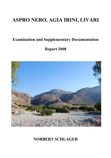
ASPRO NERO, AGIA IRINI, LIVARI<br />
Examination and Supplementary Documentation<br />
Report <strong>2008</strong><br />
NORBERT SCHLAGER
ASPRO NERO, AGIA IRINI, LIVARI<br />
Examination and Supplementary Documentation<br />
Report <strong>2008</strong><br />
by<br />
NORBERT SCHLAGER<br />
Vienna <strong>2008</strong>
FRONTISPIECE<br />
Livari.<br />
Coastal range of Kastrokephalaki with SITE 38 in the lower midground, height of Katharades with<br />
FN SITES 34 and 35 behind and to the left, rocky hill of Roussocharaki to the right, and height of<br />
Skourokephalo in the center background.
ASPRO NERO, AGIA IRINI, LIVARI: EXAMINATION AND SUPPLEMENTARY DOCUMENTATION<br />
<strong>RESEARCH</strong> <strong>REPORT</strong> <strong>FOR</strong> <strong>2008</strong><br />
Work in <strong>2008</strong> was accomplished in three weeks from July 7 to July 26 in accordance with the<br />
24th Ephoreia of Prehistoric and Classical Antiquities at Agios Nikolaos in Crete. Vili<br />
Apostolakou and Chrysa Sophianou very liberally made allowance for an earlier beginning in<br />
July as the written permit from the Greek ministry was delayed by several weeks. Krzysztof<br />
Nowicki described and classified pottery fragments on site during the two visits he made to<br />
us. J. Alexander MacGillivray of the Palaikastro Excavation Team agreed to provisionally<br />
store samples of local raw materials collected in the vicinity of the three sites under<br />
investigation at their headquarters at Agios Antonios.<br />
Aspro Nero (SITE 12)<br />
Aspro Nero, [stou] Paletsi was revisited in order to check its overall extension and the<br />
accuracy of the alignment of certain walls already documented in the 1996 field campaign. An<br />
aberration of no more than ca. 20 cm all along the distance (ca. 75 m) from the ‘North<br />
Bastion’ to ‘South Bastion’ seems tolerable. Surprisingly, more ‘Cyclopean’ walls were found<br />
abutting on the ‘North Bastion’ to the north, when an hitherto fenced off olive grove was<br />
made accessible for the first time. Documentation of the most significant stretches of walls<br />
shows close similarities in construction technique and size of stone boulders with the<br />
‘Cyclopean’ walls of the large MM/LM settlement at Chametoulo, Aletourgio/Vrysi (SITE 7),<br />
only 1.7 km to the north as the crow flies (cf. Schlager et al. 1997, 33−36 figs. 12−14). SITE<br />
12, therefore, may well be interpreted as an outlying fortified post or even a strong fortress<br />
<strong>cont</strong>rolling the low lying valley leading from the coast up to the polje of Chametoulo with its<br />
MM/LM town. The majority of datable ceramic stray finds in the area of the newly<br />
discovered walls at Aspro Nero and elsewhere on the site was clearly MM, with some LM<br />
sherds and a few pieces of Byzantine or Early Modern glazed wares. This fits well with the<br />
chronology of SITE 12 in general as already suggested (Schlager 1999, 175).<br />
At the southern border of SITE 12, further south of the ‘South Bastion’, a huge limestone<br />
outcrop, though a natural formation, clearly resembles ‘Horns of Consecration’ (Schlager<br />
1999, pl. XXVIc). Drawn and topographically determined, their long axis is nearly exactly<br />
orientated due north−south. Some distance below to the east lies a small platform, artificially<br />
brought into shape (this has been mistaken earlier for a much destroyed, possible third<br />
‘Bastion’). On its east side, another rocky outcrop with narrow and deep crevices was found<br />
which <strong>cont</strong>ained numerous fragments of MM pottery, mainly cooking pots, bowls, and cups.<br />
Deposited deliberately in the rocky fissures, the whole assemblage appears to be the waste of<br />
some feasting ceremonies held outdoors in the face of a monumental sacred landmark. Taking<br />
this all as a whole it does not seem impossible that we are dealing with one of those open-air<br />
shrines that are depicted on many a Minoan seal and gold ring of a slightly later period.<br />
<strong>2008</strong> achievements:<br />
Topographical map of entire site;<br />
Localization of raw material deposits in vicinity;<br />
Examination and minor corrections of plan of ‘North Bastion’ and ‘South Bastion’;<br />
4
ASPRO NERO, AGIA IRINI, LIVARI: EXAMINATION AND SUPPLEMENTARY DOCUMENTATION<br />
<strong>RESEARCH</strong> <strong>REPORT</strong> <strong>FOR</strong> <strong>2008</strong>, <strong>cont</strong>.<br />
Drawings and photographic documentation of ‘Cyclopean’ walls north of ‘North Bastion’;<br />
Drawings and photographic documentation of natural ‘Horns of Consecration’;<br />
Plotting, drawing and photography of stray finds (pottery and stone artifacts) of entire site.<br />
Agia Irini (SITE 20 and SITE 21)<br />
This year it has become evident that both sites actually belong to one large FN−EM II<br />
settlement that spreads from the top of Kastri down its southern and eastern slopes.<br />
Completing and fitting together three separate plans of Terrace I, Terrace II, and Terrace III<br />
into one general state plan, no substantial differences are shown in building materials and<br />
techniques of the much eroded, flimsy walls just below the top of the rocky hill, compared to<br />
the sparse remains of similar walls farther downslope admittedly in a very bad state of<br />
preservation. The earlier assumption of a later MM date of the terrace buildings (Schlager<br />
2000) must now be abandoned, although MM pottery on Terrace III is still conspicuous.<br />
Considering the vast amount of FN−EM II material strewn all across the site, the number of<br />
MM sherds on Terrace III only seem to imply a partial reoccupation, perhaps only for<br />
temporary use, of this specific area in the Middle Bronze Age, though no actual MM<br />
architectural remains have been recognized.<br />
Close scrutiny of the very top of the rocky hill, devoid of architectural features, has not<br />
provided any, not even the most insignificant fragments of terracotta statuettes, which one<br />
would expect at the site of an EM hilltop shrine or an MM peak sanctuary, given the<br />
impressive appearance of Kastri as a conspicuous landmark (for seafarers rather than for<br />
landlocked agriculturalists). On the <strong>cont</strong>rary, numerous small fragments of Melian obsidian<br />
blades and cores beside local flints, concentrated in Terraces I and II, seem to hint at knapping<br />
places and other working areas of some specialised craftsmen, who may not only have<br />
acquired or imported foreign raw materials, but have also produced a series of specific tools<br />
on the spot.<br />
Without proper excavation, or at least cleaning of the built-up area of Kastri, the whole extent<br />
and detailed appearance of this large site can only be guessed at. But even the detailed surface<br />
documentation of its visible remains, as achieved in summer <strong>2008</strong>, plotting architectural<br />
remains and stray finds alike, make it one of the largest and best known FN−EM II<br />
settlements known in the wider area between Zakros, Xerokampos, and Goudouras in SE<br />
Crete (cf. Vokotopoulos 2000; Nowicki 2003).<br />
<strong>2008</strong> achievements:<br />
Topographical map of entire site;<br />
Localization of raw material deposits in vicinity;<br />
Supplementation and completion of detailed plans of Terraces I, II, and III;<br />
Joining together of detailed plans into general state plan of top area of Kastri;<br />
Plotting, drawing and photography of stray finds (pottery and stone artifacts) of entire site.<br />
5
Livari<br />
ASPRO NERO, AGIA IRINI, LIVARI: EXAMINATION AND SUPPLEMENTARY DOCUMENTATION<br />
<strong>RESEARCH</strong> <strong>REPORT</strong> <strong>FOR</strong> <strong>2008</strong>, <strong>cont</strong>.<br />
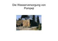
Due to its wide extent, until <strong>2008</strong> the coastal strip and plateau of Livari had not yet been<br />
surveyed in its entirety. Parts of Livari were documented in 2000: an ?EM/MM settlement at<br />
Cheromylia (SITE 36), an EM−MM I cemetery and tholos tomb at Skiadi (SITE 37), and an<br />
FN settlement at Katharades (SITE 34 and SITE 35) on high ground above and behind the<br />
coast (see Schlager et al. 2002, 192−212). This year a complete site map has been prepared,<br />
including all artificial structures (modern houses and huts, stone shelters, sheep and goat pens,<br />
threshing floors, wells, fences, field roads, heaps of accumulated field stones, grain fields and<br />
deserted fields, olive groves, beehives etc.), together with the known ancient ruins as well as a<br />
series of new ones, which have been documented in detail. Contrary to what had been<br />
suggested in the <strong>2008</strong> application, dividing the whole area of Livari into two sites, SITE 38<br />
comprising any ancient structures, and an overlying SITE 39 relating to all modern features, it<br />
has now been found convenient to apply the name of SITE 38 to all structures, ancient and<br />
modern, that lie west of the gorge of Ankastara, and north of SITE 36 and SITE 37, whereas<br />
SITE 39 refers to any structures and features east of the same gorge. The confirmed ancient<br />
sites are given in the list below:<br />
SITE 38A:<br />
FN−EM II settlement with a minimum north−south extension of 75 m along the east slope of<br />
a small coastal rocky range called locally Kastrokephalaki (Καστροκεφαλ κι).<br />
SITE 38B:<br />
Roughly quadrangular rock cut feature at the peak of Kastrokephalaki with small cleft leading<br />
into the rock; perhaps a sort of hilltop shrine above and dominating SITE 38A.<br />
SITE 38C:<br />
Walled-off and partly robbed cave in the west slope of the same range opposite SITE 38A<br />
with many EM I/II pottery sherds including one fragment of fine Vasiliki ware of EM IIB.<br />
Since no bones were detected, the function of the cave as a burial place remains doubtful,<br />
compared for example to the confirmed burial cave at Kastri Goudourou SITE 41 (cf.<br />
Schlager & Dollhofer 1998).<br />
SITE 39A:<br />
This is not ancient, but a 19th century AD walled look-out post (vigla) on top of the steep cliff<br />
cape at the eastern confines of Livari. It was obviously built in a strategic position in order to<br />
<strong>cont</strong>rol the sea below. Local inquiries drew a complete blank as to its builders: Turkish troops<br />
or Cretan andartes ?<br />
SITE 36:<br />
The published schematic plan of SITE 36 (Cheromylia) (Schlager et al. 2002, 203, fig. 16)<br />
could be supplemented with additional walls, stretches of walls, and even whole buildings,<br />
which had not been recognized as such nor documented in 2000. A new state plan of the<br />
settlement, part of which is now submerged in the sea, has been drawn. Pottery and stray finds<br />
6
ASPRO NERO, AGIA IRINI, LIVARI: EXAMINATION AND SUPPLEMENTARY DOCUMENTATION<br />
<strong>RESEARCH</strong> <strong>REPORT</strong> <strong>FOR</strong> <strong>2008</strong>, <strong>cont</strong>.<br />
analyses has confirmed a date no earlier than MM. With LM pottery also present the<br />
settlement would have been in use well into the Late Bronze Age.<br />
SITE 37:<br />
More EM and later pottery was identified and recorded in and around Tholos Tomb I within<br />
the necropolis of SITE 37 (Skiadi). On topographical grounds and because of its proximity to<br />
SITE 38A, it must be seen now as the <strong>cont</strong>emporary cemetery of the settlement SITE 38A −<br />
and not initially belonging to SITE 36 (Cheromylia), as assumed previously (Schlager et al.<br />
2002, 210).<br />
The results of the <strong>2008</strong> campaign now show clearly the local development of settlement in the<br />
area:<br />
1) FN settlement: Katharades, ‘Akropolis’ (SITE 35) and Katharades, ‘Bastion’ (SITE 34);<br />
2) FN−EM II settlement: Kastrokephalaki (SITE 38A) with cult place (SITE 38B) and cave<br />
(burial?) deposit (SITE 38C); the necropolis at Skiadi (SITE 37) probably built and in use<br />
<strong>cont</strong>emporaneously;<br />
3) MM/LM settlement at Cheromylia (SITE 36); part of cemetery at Skiadi probably still in<br />
use;<br />
4) Late Bronze Age: end of <strong>cont</strong>inuous settlement at Livari.<br />
Chaniotis’ suggestion that the classical/hellenistic settlement of ancient STALAI may be<br />
looked for at Livari (Chaniotis 1996, 386) could not be confirmed by artifactual evidence.<br />
<strong>2008</strong> achievements:<br />
New state plan of SITE 36;<br />
Additional plotting, drawing and photography of stray finds (pottery and stone artifacts) from<br />
SITE 36;<br />
Additional plotting, drawing and photography of stray finds (pottery and stone artifacts) from<br />
SITE 37;<br />
Topographical map of entire site 38;<br />
Detailed documentation of SITE 38A, SITE 38B, SITE 38C, and SITE 39A, including<br />
plotting, drawing and photography of stray finds (pottery and stone artifacts).<br />
Topographical map of entire site 39;<br />
Drawing and photography of pottery from SITE 39A;<br />
Determination and localization of local toponyms;<br />
Localization of raw material deposits in the hinterland of Livari.<br />
7
References<br />
ASPRO NERO, AGIA IRINI, LIVARI: EXAMINATION AND SUPPLEMENTARY DOCUMENTATION<br />
<strong>RESEARCH</strong> <strong>REPORT</strong> <strong>FOR</strong> <strong>2008</strong>, <strong>cont</strong>.<br />
Chaniotis, A. 1996. Die Verträge zwischen kretischen Poleis in der hellenistischen Zeit<br />
(Heidelberger Althistorische Beiträge und Epigraphische Studien 24, Stuttgart).<br />
Nowicki, K. 2003. “The End of the Neolithic in Crete,” Aegean Archaeology 6 (2002): 7—72.<br />
Schlager, N. et al. 1997. “Minoische bis rezente Ruinen im fernen Osten Kretas:<br />
Dokumentation 1996,” Jahreshefte des Österreichischen Archäologischen Institutes in<br />
Wien 66, Beiblatt: 1—84.<br />
Schlager, N. & Dollhofer, L. 1998. “Die minoische Grabhöhle Chosto im Kastri Goudourou<br />
Sitias,” Jahreshefte des Österreichischen Archäologischen Institutes in Wien 67,<br />
Beiblatt: 1—36.<br />
Schlager, N. 1999. ““A Town of Castles:” An MM/LM Fortified Site at Aspro Nero in the<br />
Far East of Crete,” in Laffineur, R. (ed.), Polemos. Le <strong>cont</strong>exte guerrier en Egée à<br />
l’âge du Bronze. Actes de la 7 e Ren<strong>cont</strong>re égéenne internationale Université de Liège,<br />
14–17 avril 1998 (Aegaeum 19, Liège & Austin, TX): 171—177.<br />
Schlager, N. 2000. Archaeological Survey in SE Crete: Site Documentation 2000. Report<br />
(Unpublished file, Vienna).<br />
Schlager, N. et al. 2002. “Pleistozäne, neolithische, bronzezeitliche und rezente Befunde und<br />
Ruinen im fernen Osten Kretas: Dokumentation 2000,” Jahreshefte des<br />
Österreichischen Archäologischen Institutes in Wien 70 (2001): 157—220.<br />
Vokotopoulos, L. 2000. “Οχυρές πρωτομινωικές θέσεις στην περιοχή Ζάκρου,” in<br />
Πεπραγμένα Η΄ Διεθνούς Κρητολογικού Συνεδρίου Ηράκλειο, 9–14 Σεπτεμβρίου 1996<br />
A1. Προϊστορική και αρχαία ελληνική περίοδος (Heraclion): 129—146.<br />
8
Project Staff<br />
ASPRO NERO, AGIA IRINI, LIVARI: EXAMINATION AND SUPPLEMENTARY DOCUMENTATION<br />
<strong>RESEARCH</strong> <strong>REPORT</strong> <strong>FOR</strong> <strong>2008</strong>, <strong>cont</strong>.<br />
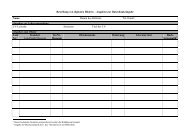
Name Profession Scientific Origin Labour Supply___<br />
and Duty<br />
Dr. Norbert Schlager Archaeologist, University of Vienna: 04/07 − 08/08/<strong>2008</strong><br />
University Project Director<br />
Lecturer<br />
Dr. Tomas Alusik Archaeologist University of Prague: 06/07 − 27/07/<strong>2008</strong><br />
Site Documentation<br />
Mag. Michael Brandl Raw Material Austrian Academy of 05/07 − 26/07/<strong>2008</strong><br />
Analyst Sciences:<br />
Ceramic & Stone Artifacts<br />
Analyses<br />
Ludwig Fuchs Student of University of Bamberg: 06/07 − 26/07/<strong>2008</strong><br />
Archaeology Documentation of<br />
Pottery & Stone Artifacts<br />
Mag. a Ute Günkel- Archaeologist University of Heidelberg: 06/07 − 26/07/<strong>2008</strong><br />
Maschek Site Documentation<br />
Dipl. Ing. (FH) Geodesist Austrian Archaeological 05/07 − 26/07/<strong>2008</strong><br />
Christian Kurtze Institute:<br />
Site Surveyor<br />
Mag. a Elisabeth Mlinar Archaeologist University of Vienna: 06/07 − 28/07/<strong>2008</strong><br />
Site Documentation,<br />
Photography<br />
Marco Pietrovito, M.A. Archaeologist Université de Montréal: 07/07 − 27/07/<strong>2008</strong><br />
Documentation of<br />
Pottery & Stone Artifacts<br />
Mag. Wolfgang Reiter Archaeologist, University of Vienna: 06/07 − 26/07/<strong>2008</strong><br />
Teacher Site Surveyor & Site<br />
Documentation,<br />
Photography<br />
Rhea Schlager Student Electronic Archives & 04/07 − 08/08/<strong>2008</strong><br />
Photography Management<br />
9
Aspro Nero Raw Material Deposits and Location of Samples (AN = Aspro Nero)
Agia Irini Raw Material Deposits and Location of Samples (AI = Agia Irini)
Livari Raw Material Deposits and Location of Samples
Project Staff <strong>2008</strong> Back row from left: W. Reiter, M. Pietrovito, U. Günkel-Maschek, R. Schlager, T. Alusik;<br />
front row from left: L. Fuchs, N. Schlager, E. Mlinar, M. Brandl, C. Kurtze.<br />
SITE 39A Livari, Chlios. 19th century AD look-out post from NE.
SITE 12C Aspro Nero, Pezaridia. Natural limestone outcrop in the shape of ‘Horns of Consecration’, from SE.<br />
SITE 12A Aspro Nero, [stou] Paletsi. “Cyclopean” wall AA−BB north of ‘North Bastion’ from NNE.
SITE 12C Aspro Nero, Pezaridia. Rock formation with flint inclusions and deep cleft.<br />
SITE 12C Aspro Nero, Pezaridia. Rocky cliff with flint inclusions.
SITE 21 Agia Irini, Kastri. South-east slope with faint remains of FN − EM II remains, view from E.<br />
SITE 21 Agia Irini, Kastri. South-east slope with faint remains of FN − EM II remains, view from above.
SITE 38 Livari, Kastrokephalaki. Rocky range with settlement remains and rock cut feature on top of hillock, view<br />
from SE.<br />
SITE 38A Livari, Kastrokephalaki. Steps between Rooms 6/7 and 13/19 in Structure I.
SITE 38B Livari, Kastrokephalaki. Rock-cut feature on top of hill, view from SW.<br />
SITE 38B Livari, Kastrokephalaki. Rock-cut feature with cleft leading into rock, from S.
SITE 38C Livari, Kastrokephalaki. Conglomerate cave, entrance.<br />
SITE 38C Livari, Kastrokephalaki. Conglomerate cave, interior with U. Günkel-Maschek.