Histories of Green Square - City of Sydney
Histories of Green Square - City of Sydney
Histories of Green Square - City of Sydney

Create successful ePaper yourself
Turn your PDF publications into a flip-book with our unique Google optimized e-Paper software.
<strong>Histories</strong> <strong>of</strong> <strong>Green</strong> <strong>Square</strong><br />
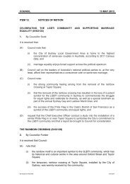
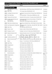
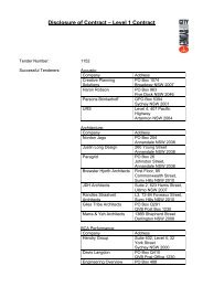
Fig. 7.1 Lithographed map <strong>of</strong> Waterloo, Parish <strong>of</strong> Alexandria, County <strong>of</strong> Cumberland, c1885,<br />
from a collection <strong>of</strong> <strong>Sydney</strong> suburban maps published by Higinbotham and Robinson.<br />
(Source: ML ref. F981.1/H, courtesy Mitchell Library, State Library <strong>of</strong> New South Wales.)<br />
56<br />
© Jeff Fairman<br />
The natural watercourses were essential for use in many industries,<br />
including the numerous tanneries, wool washes, soap<br />
factories, glassmakers and brewers. 4 Unfortunately, at a time<br />
<strong>of</strong> little regulation regarding either public health or industrial<br />
pollution, these uses <strong>of</strong>ten resulted in public health issues, and<br />
the degradation <strong>of</strong> the water supply. The Alexandra Canal was<br />
one such waterway: until recently it was considered one <strong>of</strong><br />
<strong>Sydney</strong>’s most polluted waterways. 5<br />
Daniel Cooper, a prominent businessman, acquired both the<br />
Mount Lachlan and Waterloo Estates in 1829 and 1825 respectively.<br />
The Cooper family held this vast area right up until<br />
the beginning <strong>of</strong> World War One. 6 Subdivision in the area<br />
was largely a result <strong>of</strong> the release and sale <strong>of</strong> small parcels <strong>of</strong><br />
these Cooper Estates, from the 1850s up until 1914. Thus the<br />
appearance <strong>of</strong> subdivision was contingent upon the Coopers’<br />
own financial situation, the price <strong>of</strong> land, and the economy. 7<br />
7.2.3 The first subdivision<br />
The first recorded subdivision occurred in 1853, when allotments<br />
‘ranging from 20 feet to 60 feet frontage’ were <strong>of</strong>fered. 8<br />
Unfortunately, to date there is no detail <strong>of</strong> exactly where in<br />
Waterloo this was located. However, likely places for the<br />
earliest subdivision were along Wellington and Raglan Streets,<br />
where some <strong>of</strong> the oldest residential buildings in Waterloo,<br />
dating from the late 1870s, can be found. Interestingly, Mt<br />
Carmel (Catholic) and Mt Lachlan (now Uniting) churches<br />
are the oldest surviving buildings still standing in Waterloo.<br />
The land for both <strong>of</strong> these was granted by Daniel Cooper—<br />
first Mt Carmel in 1859, and then Mt Lachlan in 1860. 9 The<br />
lure <strong>of</strong> employment in industries such as those established by<br />
Daniel Cooper attracted people to the area as early as 1815,<br />
but the major boom in population occurred fifty years later,<br />
firstly in Redfern in the 1860s, and in the following decades in<br />
Waterloo and Alexandria.<br />
Waterloo was incorporated as a borough in May 1860, after<br />
successfully petitioning for independence from the borough <strong>of</strong><br />
Redfern, established just one year earlier. 10 Until the Town Hall<br />
was completed in 1882, the Council met in a room attached<br />
to Quin’s Bakery. 11 Subdivision prior to 1880 was localised<br />
around the area bounded by Wellington, Raglan and Elizabeth<br />
Streets, which marked the heart <strong>of</strong> the town. It seems that even<br />
at this early stage <strong>of</strong> development, much <strong>of</strong> the growth was<br />
based on venture capital. It is likely that the first housing in<br />
the area was built by speculative investors, who thus played<br />
a key role in providing housing in these outer suburbs <strong>of</strong><br />
<strong>Sydney</strong>. 12 In Wellington Street, for example, as Susan O’Reilly<br />
also discusses in Chapter 13, ‘virtually every dwelling in the<br />
Street was constructed by James Schimmel in the late 1870s’,<br />
and this was not an unusual achievement. 13 The extraordinary<br />
growth in <strong>Sydney</strong>’s population in the boom years provided<br />
excellent opportunity for pr<strong>of</strong>its for those with capital to<br />
invest, as there was an enormous demand for housing. Often,<br />
though, this housing was <strong>of</strong> substandard quality to maximise<br />
pr<strong>of</strong>it margins.<br />
The Australian colonies were marketed as a ‘worker’s paradise’<br />
to prospective immigrants in Britain, and those who migrated<br />
expected a land <strong>of</strong> prosperity, decent housing and work for<br />
all. 14 But this was far from reality in Waterloo, and indeed in<br />
many parts <strong>of</strong> <strong>Sydney</strong>. As we shall see, regulation <strong>of</strong> housing<br />
development was rare, while exploitation was common. The<br />
severe problems really came to a head during the ‘boom era’ <strong>of</strong><br />
the 1880s and the bust <strong>of</strong> the 1890s.<br />
© Jeff Fairman<br />
Chapter 7 – Waterloo: Whose fault were the slums?<br />
7.3 Thirty years <strong>of</strong> change, 1880–1910<br />
Throughout the 1870s, <strong>Sydney</strong>’s suburban population experienced<br />
a remarkable period <strong>of</strong> growth culminating in the<br />
1880s, when, for the first time, the suburban population<br />
exceeded that <strong>of</strong> the city wards. With a population that had<br />
grown from 135,000 in 1871 to 383,283 by 1891, <strong>Sydney</strong><br />
had experienced astounding growth in a short time, but this<br />
increase was greatest in suburbs such as Redfern, Paddington,<br />
and Balmain. 15 While the <strong>City</strong> had previously been the most<br />
crowded place in <strong>Sydney</strong>, this was no longer the case by 1891.<br />
By then many <strong>of</strong> the fringe working-class suburbs, including<br />
Waterloo, were just as crowded. House construction and subdivision<br />
peaked there in the 1880s.<br />
7.3.1 Growth <strong>of</strong> the suburb<br />
Subdivision in the 1880s occurred south <strong>of</strong> the established<br />
town <strong>of</strong> Waterloo, following the lines <strong>of</strong> the major streets—<br />
Bourke and Botany Streets and down Elizabeth Street. Subdivided<br />
lands were aimed at ‘Working men, Artisans, Mechanics’<br />
alike. 16 Land closer to the Waterloo swamp and Dam was the<br />
first to be <strong>of</strong>fered in the 1880s, such as the Zetland Estate<br />
in Portman and Merton Streets, which was located just <strong>of</strong>f<br />
Bourke Street and near the site <strong>of</strong> the proposed <strong>Green</strong> <strong>Square</strong><br />
Town Centre. 17 The Zetland Estate allotments were <strong>of</strong>fered<br />
for sale on Saturday 13 th June 1885, and comprised 289 allotments,<br />
all roughly 100 feet long by 20 feet wide, the long,<br />
narrow shape <strong>of</strong> terraced housing. 18 As a result, the houses<br />
built on these site were primarily terraces, built in Victorian<br />
Italianate style, though some variations can be found. The<br />
other style <strong>of</strong> housing still extant in this area is the small freestanding<br />
workers’ cottage, which tends to be single storey, and<br />
constructed from timber.<br />
Subdivision was rarely successful on the first sale, and allotments<br />
were <strong>of</strong>ten <strong>of</strong>fered for sale over a number <strong>of</strong> years.<br />
In Waterloo, land sales tended to occur in clusters (such as<br />
between 1880 and 1890, in 1900 and then between 1910 and<br />
1916). The Zetland Estate is an example <strong>of</strong> this pattern, as the<br />
sale <strong>of</strong> land surrounding Bourke, Botany and Elizabeth Streets<br />
continued with another sale in 1903 and again in 1911. Still<br />
further south, the Victoria Estate subdivision, near Epsom and<br />
Hansard Streets, was <strong>of</strong>fered for sale in 1912. 19<br />
The presence <strong>of</strong> both terrace and cottage style housing suggests<br />
that there were two different classes <strong>of</strong> workers in the area.<br />
Those who lived in the more substantial and elaborate terraces<br />
tended to be artisans or skilled workers, while the workers’<br />
cottages were occupied, primarily, by unskilled labourers and<br />
factory workers. The Sands <strong>Sydney</strong> Directory for 1890 reveals<br />
that ninety per cent <strong>of</strong> those people living in Portman Street<br />
had trades, and included painters, stonemasons, an engineer,<br />
boot makers, builders, and grocers. In Raglan Street Sands<br />
lists a jeweller at 22 Raglan Street, an ironmonger, bricklayers,<br />
dairy keepers, florists and butchers. While these occupations<br />
by today’s standards might seem laborious and not <strong>of</strong><br />
particularly high status, it should be noted that these were<br />
skilled trades, and that therefore these people were likely to<br />
have enjoyed leisure time (those who worked the eight hour<br />
day at least) and regular and partly disposable incomes. 20<br />
What was life like for these skilled labourers? Certainly there<br />
was a degree <strong>of</strong> material wealth as artisans earned more<br />
money than unskilled workers, but it was also the regularity<br />
<strong>of</strong> work that a skilled worker could expect which allowed the<br />
improvement <strong>of</strong> material life and comfort. However, there<br />
was also a degree <strong>of</strong> pressure to aspire to more middle class<br />
57