ATLAS PARASOUND
ATLAS PARASOUND
ATLAS PARASOUND

You also want an ePaper? Increase the reach of your titles
YUMPU automatically turns print PDFs into web optimized ePapers that Google loves.
Echosounders for more than<br />
100 Years<br />
Ideal Instrument for Science<br />
and UNCLOS Mapping<br />
High Resolution Sediment<br />
Information at Full Ocean<br />
Depth Capability<br />
Acoustic Measurements for<br />
Water Column, Bathymetry<br />
and Sidescan<br />
Marine Mammal Protection<br />
<strong>ATLAS</strong> PARASTORE<br />
Acquisition and Processing<br />
Software<br />
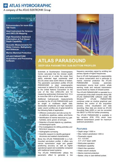
<strong>ATLAS</strong> <strong>PARASOUND</strong><br />
DEEP-SEA PARAMETRIC SUB-BOTTOM PROFILER<br />
Scientists at Southampton Oceanography<br />
Centre calculated that the mineral wealth<br />
lying around on or under the ocean floor<br />
within extended legal continental shelf<br />
(ELCS) areas were worth trillions of dollars.<br />
The parametric sub-bottom profiler <strong>ATLAS</strong><br />
<strong>PARASOUND</strong> is ideal oceanographic<br />
instrument to define ELCS areas according<br />
to the United Nations Convention on the<br />
Law of the Sea (UNCLOS) and for<br />
measuring sedimentary thickness from 10 m<br />
to more than 200 m at full ocean depth.<br />
Additional hydroacoustic measurements<br />
provided by the <strong>ATLAS</strong> <strong>PARASOUND</strong> such<br />
as single- or multibeam depth data,<br />
backscatter amplitudes and high resolution<br />
water column profiles are of great benefit to<br />
the following fields of application:<br />
� Offshore construction and site survey for<br />
oil platforms, pipelines, cables, wind farms<br />
� Identification of marine resources e.g. gas<br />
hydrates, sand, gravel, oil and gas.<br />
� Detection of buried objects e.g. pipelines,<br />
archaeological spots.<br />
� Pre-investigations for drilling activities and<br />
ROV/AUV missions.<br />
� Hydrographic surveying.<br />
� Scientific research to identify geological<br />
structures and seabed characteristics.<br />
Since the <strong>ATLAS</strong> <strong>PARASOUND</strong> is a hullmounted<br />
sub-bottom profiler, it offers very<br />
narrow transmission angle and greater<br />
positioning accuracy as well as higher<br />
operational speed and availability compared<br />
with traditional towed systems.<br />
The <strong>ATLAS</strong> <strong>PARASOUND</strong> utilises the<br />
parametric effect to generate a low<br />
frequency secondary signal by emitting two<br />
primary signals of higher frequencies.<br />
Due to <strong>ATLAS</strong> Hydrographic’s responsibility<br />
to nature conservation and in particular to<br />
marine mammal protection the <strong>ATLAS</strong><br />
<strong>PARASOUND</strong> includes automatic<br />
transmission source level control, whale<br />
warning mode and reduced transmission<br />
source levels by means of chirped pulses.<br />
The <strong>ATLAS</strong> <strong>PARASOUND</strong> is operated by a<br />
commercial of the shelf computer along with<br />
<strong>ATLAS</strong> PARASTORE software under MS<br />
Windows TM . <strong>ATLAS</strong> PARASTORE<br />
combines under an intuitive graphical user<br />
interface the control of the acquisition<br />
process, online visualisation and data<br />
recording. Raw data are stored as <strong>ATLAS</strong><br />
Sounding Data (ASD) or can be converted<br />
into SEG-Y or PS3 for further processing.<br />
The <strong>ATLAS</strong> <strong>PARASOUND</strong> is available in<br />
two versions (P35, P70) which have<br />
different transmission power for maximum<br />
sediment penetration.<br />
FEATURES<br />
� Depth range 11000 m<br />
� Max. bottom penetration >200 m<br />
� Parametric signal:<br />
0.5 – 6.0 kHz<br />
4.5° x 5.0° beam width<br />
� Multi-pulse operation<br />
� Multibeam capability<br />
� Watch-free operation<br />
� Water column analysis<br />
� Marine mammal protection<br />
� Barker, chirp or user-defined pulses
THE ECHOSOUNDER<br />
AT A GLANCE …<br />
Bottom Penetration<br />
>200 m at Full Ocean Depth *<br />
Parametric Frequency<br />
0.5 to 6.0 kHz<br />
Beam Width 4.5° x 5.0°<br />
Barker, Chirp, CW or<br />
User-Defined Pulses<br />
Watch-Free Operation<br />
Multi-Ping Capability<br />
Contact<br />
<strong>ATLAS</strong> Hydrographic GmbH<br />
Kurfürstenallee 130<br />
28211 Bremen, Germany<br />
Tel +49 421 457-2259<br />
Fax +49 421 457-3449<br />
www.atlashydro.com<br />
sales-hydro@atlas-elektronik.com<br />
FREQUENCY BANDS<br />
� High frequency: 18 – 33 kHz<br />
� Parametric low frequency: 0.5 – 6.0 kHz<br />
SEDIMENT PENETRATION/ DEPTH RANGE*<br />
� Penetration P70 >200 m<br />
� Penetration P35 >150 m<br />
� Depth range 10 – 11000 m<br />
* depending on local bottom and environmental conditions<br />
ALONG TRACK BEAM RESOLUTION<br />
� High frequency: 4.0° @ 18 kHz<br />
� Low frequency: 4.5° @ 0.5 to 6.0 kHz<br />
ACROSS TRACK BEAM RESOLUTION<br />
� High frequency: 4.5° @ 18 kHz<br />
� Low frequency: 5.0° @ 0.5 to 6.0 kHz<br />
TRANSMISSION POWER<br />
� P70: 70 kW<br />
� P35: 35 kW<br />
TRANSMISSION SOURCE LEVEL<br />
� P70: 245 dB / 206 dB (primary / parametric)<br />
� P35: 242 dB / 200 dB (primary / parametric)<br />
PING RATE<br />
� Maximum ping rate 20 Hz<br />
MULTI-PING<br />
� Up to 16 simultaneous pings<br />
� Quasi-equidistant mode<br />
MOTION CORRECTION<br />
� Roll ± 10° stabilised<br />
� Pitch ± 5° stabilised<br />
� Yaw ± 10° stabilised<br />
� Heave<br />
<strong>ATLAS</strong> <strong>PARASOUND</strong><br />
DEEP-SEA PARAMETRIC SUB-BOTTOM PROFILER<br />
PULSE MODULATION<br />
� 0.17 – 25 ms pulse lengths<br />
� Barker, chirp, CW and<br />
User-defined pulse shapes<br />
RESOLUTION AND ACCURACY<br />
� Max. range resolution 6.1 cm<br />
� Max. output sample rate 12.2 kHz<br />
� Sediment layer resolution: down to