Neighbourhood Greenprint - Halifax Regional Municipality
Neighbourhood Greenprint - Halifax Regional Municipality
Neighbourhood Greenprint - Halifax Regional Municipality

Create successful ePaper yourself
Turn your PDF publications into a flip-book with our unique Google optimized e-Paper software.
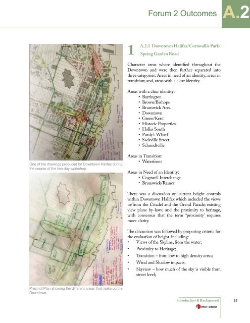
One of the drawings produced for Downtown <strong>Halifax</strong> during<br />
the course of the two day workshop.<br />
Precinct Plan showing the different areas that make up the<br />
Downtown.<br />
1<br />
A.2.1 Downtown <strong>Halifax</strong>/Cornwallis Park/<br />
Spring Garden Road<br />
Character areas where identified throughout the<br />
Downtown and were then further separated into<br />
three categories: Areas in need of an identity; areas in<br />
transition; and, areas with a clear identity.<br />
Areas with a clear identity:<br />
• Barrington<br />
• Brown/Bishops<br />
• Brunswick Area<br />
• Downtown<br />
• Green/Kent<br />
• Historic Properties<br />
• Hollis South<br />
• Purdy’s Wharf<br />
• Sackville Street<br />
• Schmidtville<br />
Areas in Transition:<br />
• Waterfront<br />
Forum 2 Outcomes<br />
Areas in Need of an Identity:<br />
• Cogswell Interchange<br />
• Brunswick/Rainee<br />
There was a discussion on current height controls<br />
within Downtown <strong>Halifax</strong> which included the views<br />
to/from the Citadel and the Grand Parade; existing<br />
view plane by-laws; and the proximity to heritage,<br />
with consensus that the term “proximity’ requires<br />
more clarity.<br />
The discussion was followed by proposing criteria for<br />
the evaluation of height, including:<br />
• Views of the Skyline, from the water;<br />
• Proximity to Heritage;<br />
• Transition – from low to high density areas;<br />
• Wind and Shadow impacts;<br />
• Skyview – how much of the sky is visible from<br />
street level;<br />
Introduction & Background<br />
A.2<br />
25