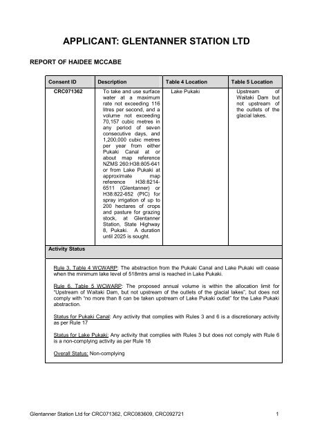
APPLICANT: GLENTANNER STATION LTD - Environment Canterbury
APPLICANT: GLENTANNER STATION LTD - Environment Canterbury
APPLICANT: GLENTANNER STATION LTD - Environment Canterbury

Create successful ePaper yourself
Turn your PDF publications into a flip-book with our unique Google optimized e-Paper software.
<strong>APPLICANT</strong>: <strong>GLENTANNER</strong> <strong>STATION</strong> <strong>LTD</strong><br />
REPORT OF HAIDEE MCCABE<br />
Consent ID Description Table 4 Location Table 5 Location<br />
CRC071362 To take and use surface<br />
water at a maximum<br />
rate not exceeding 116<br />
litres per second, and a<br />
volume not exceeding<br />
70,157 cubic metres in<br />
any period of seven<br />
consecutive days, and<br />
1,200,000 cubic metres<br />
per year from either<br />
Pukaki Canal at or<br />
about map reference<br />
NZMS 260:H38:805-641<br />
or from Lake Pukaki at<br />
approximate map<br />
reference H38:8214-<br />
6511 (Glentanner) or<br />
H38:822-652 (PIC) for<br />
spray irrigation of up to<br />
200 hectares of crops<br />
and pasture for grazing<br />
stock, at Glentanner<br />
Station, State Highway<br />
8, Pukaki. A duration<br />
until 2025 is sought.<br />
Activity Status<br />
Lake Pukaki Upstream of<br />
Waitaki Dam but<br />
not upstream of<br />
the outlets of the<br />
glacial lakes.<br />
Rule 3, Table 4 WCWARP: The abstraction from the Pukaki Canal and Lake Pukaki will cease<br />
when the minimum lake level of 518mtrs amsl is reached in Lake Pukaki.<br />
Rule 6, Table 5 WCWARP: The proposed annual volume is within the allocation limit for<br />
“Upstream of Waitaki Dam, but not upstream of the outlets of the glacial lakes”, but does not<br />
comply with “no more than 8 can be taken upstream of Lake Pukaki outlet” for the Lake Pukaki<br />
abstraction.<br />
Status for Pukaki Canal: Any activity that complies with Rules 3 and 6 is a discretionary activity<br />
as per Rule 17<br />
Status for Lake Pukaki: Any activity that complies with Rules 3 but does not comply with Rule 6<br />
is a non-complying activity as per Rule 18<br />
Overall Status: Non-complying<br />
Glentanner Station Ltd for CRC071362, CRC083609, CRC092721 1
Consent ID Description Table 4 Location Table 5 Location<br />
CRC083609 To take and use<br />
surface water at a rate<br />
of 116 litres per<br />
second, with a volume<br />
not exceeding 70,157<br />
cubic metres per week<br />
and with a volume not<br />
exceeding 1,200,000<br />
cubic metres per<br />
season from the<br />
Tekapo Stilling basin at<br />
or about map reference<br />
H38:8820-7260 and<br />
H38:8842-7328 for the<br />
purposes of irrigation<br />
Activity Status<br />
Lake Tekapo Upstream of<br />
Waitaki Dam but<br />
not upstream of<br />
the outlets of the<br />
glacial lakes.<br />
Rule 3, Table 4 WCWARP: The abstraction from the Tekapo Stilling Basin will cease when the<br />
following lake levels are reached for Lake Tekapo:<br />
a) a minimum lake level of 701.8mtrs amsl during the months of April to September<br />
inclusive<br />
b) a minimum lake level of 704.1mtrs amsl during the months of October to March inclusive<br />
except as provided for in c)<br />
Rule 6, Table 5 WCWARP: The proposed annual volume is within the allocation limit for<br />
“Upstream of Waitaki Dam, but not upstream of the outlets of the glacial lakes”<br />
Overall status: Any activity that complies with Rules 3 and 6 is a discretionary activity as<br />
per Rule 17<br />
Consent ID Description<br />
CRC092721 To construct, use and maintain an intake structure to facilitate the<br />
abstraction of water from Lake Pukaki between map reference<br />
H38:8235-6520 and H38:8214-6511<br />
Activity Status<br />
TRP: There is no operative regional plan so S77C of the RMA applies, and the activity is<br />
discretionary.<br />
NRRP: The activity may not comply with condition 9 of Rule BLR2 (discharge of sediment). Rule<br />
BLR3 re possibly condition 2 (500mm diameter rocks), 3 (volume excavated) or 8 of (works in<br />
surface water), therefore the activity is discretionary under rule BLR8.<br />
Overall status: Discretionary<br />
Glentanner Station Ltd for CRC071362, CRC083609, CRC092721 2
1 PROPOSAL<br />
1. Glentanner Station Ltd (herein referred to as ‘the applicant’) farms Catherine Fields, adjacent to State<br />
Highway 8 (but not visible) below Lake Pukaki, between Twizel and Tekapo where the proposed<br />
irrigation development is to be undertaken.<br />
2. The applicant applied for CRC071362 on the 7 November 2006. This application seeks to take and<br />
use 116 litres per second of surface water from either Pukaki Canal (Option 1) at approximate map<br />
reference NZMS 260:H38:805-641 or Lake Pukaki (Option 2) at approximate map reference<br />
H38:8214-6511 (Glentanner) or H38:822-652 (Pukaki Irrigation Company Ltd - PIC) to irrigate 200ha<br />
as shown in Appendix A.<br />
3. The applicant applied for CRC083609 (Option 3) on the 25 March 2008 to take and use surface water<br />
at a rate of 116 litres per second, from the Tekapo Stilling Basin, to irrigate the same 200ha as already<br />
proposed. The intake location is between map reference H38:8820-7260 and H38:8842-7324. The<br />
intake structure and design is part of the (PIC) scheme application to supply several properties. The<br />
pipeline will be gravity fed to the property.<br />
4. The applicants proposed consents to take water, are consistent with Pukaki Irrigation Company Ltd<br />
(PIC) scheme land use consents. Consequently there are three sources of water from four locations<br />
that could supply water to the same 200Ha area proposed for irrigation at Catherine Fields.<br />
5. Land use consent CRC092721 was applied for on the 22 December 2008 to construct, use and<br />
maintain an intake structure to facilitate the abstraction of water from Lake Pukaki. This is required to<br />
maintain a level of independence and security should the PIC schemes not proceed or is unfeasible to<br />
the applicant.<br />
6. The intake is proposed to consist of a pipeline with a stainless steel intake screen located below the<br />
minimum lake level of 518mtrs. This will provide for an intake structure to supply Option 2<br />
independently from Lake Pukaki for CRC071362.<br />
7. The applicant is working with PIC whom have applied for the required land use consents (as detailed<br />
above) to construct intakes and facilitate scheme water for all three scheme options. However the<br />
applicant wishes to ensure that they have the necessary consents to be self-sufficient, hence why<br />
CRC092721 is required.<br />
1.1 Timeline and Summary of Amendments made to the Applications<br />
Timeline CRC071362 CRC083609 CRC092721<br />
Date of Lodging<br />
Notifiable Date<br />
Public Notification<br />
07 November 2006 25 March 2008 22 December 2008<br />
07 February 2007 07 May 2008 N/A<br />
04 August 2007 18 October 2008 18 February 2009<br />
8. CRC071362, in January 2007 confirmation was provided that the minimum lake level of 518 mtrs amsl<br />
for Lake Pukaki as per Table 4 would be complied with.<br />
9. CRC071362, in December 2008 it was confirmed that the volume of water notified was for irrigation<br />
only. Stock water requirements were justified but it was indicated that Section 14 3) b of the RMA was<br />
being reliant on for this water.<br />
10. CRC083609, during May 2008 confirmation was provided that the minimum lake levels for Lake<br />
Tekapo would apply.<br />
11. CRC083609, in June 2009 confirmation was required that the intake location now needed to be<br />
located a further 50mtrs upstream to be consistent with PIC. It was proposed that CRC083609 and<br />
CRC071362 would not be used concurrently. The standard MIC conditions were accepted when the<br />
canal is maintained or inflows restricted except for stockwater. It was also clarified that stockwater was<br />
in addition to the irrigation volume.<br />
12. In July 2009 the Ecan IO confirmed the following amendments proposed, as outlined below were<br />
accepted given they were considered to be within the scope of the original notification:<br />
Glentanner Station Ltd for CRC071362, CRC083609, CRC092721 3
13. CRC083609: the upper extent of the notified range for location of the take from the Tekapo Stilling<br />
Basin to shift 50mtrs upstream, from H38:8845-7324 to H38:8842-7328.<br />
14. CRC092721: the shifting of the western extent of the notified intake range for Lake Pukaki from H38:<br />
817-6517 by 80mtrs to the south, to H38:8214-6511. Plus to change the intake design concept to<br />
accommodate the abstraction further from the shore to ensure the minimum lake level is reached and<br />
to meet Meridian Energy Ltd requirements.<br />
15. CRC071362: to include two possible take locations from Lake Pukaki (in addition to the Pukaki canal<br />
take):<br />
16. One consistent with the independent intake CRC092721 (H38: 8214-6511) which is approximately<br />
160mtrs from the notified location<br />
17. One consistent with PIC change in location of CRC062866 (at H38:822-652 which is approximately<br />
100mtrs from the notified location<br />
18. No other amendments have been made to these applications.<br />
2 BACKGROUND INFORMATION<br />
2.1 Farm Details<br />
19. Glentanner Station Ltd (herein referred to as ‘the applicant’) farms Catherine Fields, adjacent to State<br />
Highway 8 (but not visible), between Twizel and Tekapo where the proposed irrigation development is<br />
to be undertaken.<br />
20. Catherine Fields is a 435ha property that is run in conjunction with Glentanner Station, a 16,000ha<br />
high country property. Both of these properties are on one title.<br />
21. Collectively both Glentanner and Catherine Fields run 10,000 SU with approximate proportions of 80%<br />
being sheep, 15% beef cattle and 5% deer.<br />
22. At present Catherine Fields is primarily used as a finishing farm for Glentanner and running stud<br />
merino ewes plus all of the hoggets are wintered there. All of the Glentanner annual draft ewes are<br />
sent to Catherine Fields in October, lambed there and then the ewes are sold.<br />
23. The applicants intention is to continue to use Catherine Fields as they presently do, however with<br />
irrigation there will be an addition of cattle, finishing of more sheep and an increase in capital sheep<br />
stock.<br />
2.2 Water Source<br />
24. There are three water sources related to these applications; Pukaki Canal (between Lake Pukaki and<br />
Ruataniwha), Lake Pukaki and the Tekapo Stilling Basin (canal between Lake Tekapo and Lake<br />
Pukaki).<br />
25. The Pukaki Canal (CRC071362 – Option 1) is 12km long, carrying water from Lake Pukaki to Lake<br />
Ruataniwha and is mechanically operated by Meridian Energy and therefore the environmental values<br />
are minor. Salmon are known to inhabit the canal as well as the possibility of other fisheries species<br />
since fish are able to enter through the Pukaki control gate.<br />
26. Lake Pukaki (CRC071362 – Option2) is the largest glacial lake with an area of approximately 169<br />
km2. Three major rivers contribute to its inflows; the Tasman, Jollie and Hooker Rivers plus smaller<br />
tributaries. Tekapo B power station discharges into Lake Pukaki and also contributes a large<br />
proportion of its inflows, which are controlled by Meridian Energy. The lake levels vary significantly and<br />
the normal operating range is between 532mtrs and 518mtrs above sea level depending on the time of<br />
year and Meridian Energy’s management. The fisheries, flora and fauna values are highest where the<br />
rivers flow into Lake Pukaki, with numerous wildlife habitats. Fish species that have been recorded in<br />
Lake Pukaki are brown trout, common bully, <strong>Canterbury</strong> galaxies, koaro, long-finned eel and rainbow<br />
trout. The habitat value for brown and rainbow trout is low.<br />
27. The Tekapo Canal (CRC083609 – Option 3) carries a substantial volume of water from Lake Tekapo<br />
to Lake Pukaki via the Tekapo B power station. The canal is some 26.5km in length and averages a<br />
depth of 5.3 meters. The Tekapo stilling basin is located just prior to the Tekapo B powerstation where<br />
the water then discharges into Lake Pukaki. Salmon inhabit the canal and are farmed a few kilometres<br />
Glentanner Station Ltd for CRC071362, CRC083609, CRC092721 4
upstream of the proposed abstraction point. Other fisheries species present in the canal are rainbow<br />
and brown trout.<br />
2.3 Mackenzie Irrigation Company Shares held<br />
Name: Glentanner Station Ltd Number<br />
Property Shares<br />
Irrigation Shares<br />
28. Irrigation shares are required for the full irrigation area as this is a new consent.<br />
2.4 Derogation Approval<br />
29. Derogation approval was obtained from Meridian Energy Limited on the 11 th September for<br />
CRC083609 and CRC071362 (for Lake Pukaki only, Option 2). Final derogation approval was<br />
received for all consent and intake options proposed, including the Pukaki Canal on the 29 th<br />
September 2009 as attached in Appendix D.<br />
3 COMMENTS ON SUBMISSIONS<br />
30. A summary of the submissions for: CRC071362 notified in 2007, CRC083609 in 2008 and<br />
CRC092721 in February 2009.<br />
Resource<br />
Consent<br />
Glentanner Station Ltd for CRC071362, CRC083609, CRC092721 5<br />
1<br />
200<br />
Submissions in support Submission in opposition Neutral<br />
CRC071362 4 16 2<br />
CRC083609 4 6<br />
CRC092721 1 1<br />
31. Details of the submissions made in response to all applicants that were publically notified at the same<br />
time in 2007 are contained in CRC Report 1, Appendix 5. I have reviewed this report and consider it<br />
as a true and accurate summary of the submissions received.<br />
32. Details of the submissions received that are not common to all applications are as follows:<br />
Consent<br />
Number<br />
CRC071362 Mr Mark<br />
Urquhart,<br />
Grays Hills<br />
Station<br />
CRC083609 Mr Anthony<br />
Gloag,<br />
Buscot<br />
Station<br />
CRC083609 Mr William<br />
Murray,<br />
Glenmore<br />
Station<br />
Submitter Issues Support/<br />
Spray irrigation will be an efficient use of<br />
water with minimal effect.<br />
Sustain the physical resource, whilst<br />
protecting the natural resource by reducing<br />
rabbit infestation proneness and mitigating<br />
soil degradation.<br />
Irrigation in the Mackenzie is vital for<br />
sustainable land management and diversify in<br />
today’s farming environment.<br />
neutral/oppose<br />
Support<br />
Support<br />
Support
Consent<br />
Number<br />
All 3<br />
applications<br />
Submitter Issues Support/<br />
Ruataniwha<br />
Farms Ltd<br />
CRC083609 Dan and<br />
Kerryn<br />
Thomas,<br />
Killermont<br />
Station<br />
CRC071362<br />
CRC083609<br />
CRC092721<br />
All 3<br />
applications<br />
Meridian<br />
Energy Ltd<br />
Fish and<br />
Game NZ<br />
Central<br />
South<br />
Island<br />
CRC071362 NZ<br />
Transport<br />
Agency<br />
It (irrigation) will make the farm more viable,<br />
make more hay and silage and fatten surplus<br />
stock.<br />
Support new irrigation, agricultural growth<br />
and sustainability<br />
Need to comply with MIC tranching, water<br />
quality both cumulative and individual, MEL<br />
controlled low flows not accommodated,<br />
effects on MEL infrastructure, water metering,<br />
contrary to Part II RMA.<br />
Need to allow for full operating range of the<br />
Lake, need to control sediment and erosion<br />
and outline of protection works, effects on<br />
MEL infrastructure<br />
General submission on all Lake or canal<br />
takes relating to volumetric allocation limit in<br />
Table 5 being exceeded.<br />
Clarification required on SH8 road crossing<br />
and that a Deed of Grant will be required<br />
neutral/oppose<br />
Support<br />
Support<br />
Oppose<br />
Oppose<br />
Oppose<br />
33. Consultation with MEL has been ongoing and in June 2009 general agreement on the location and<br />
revised concept had been reached to address their concerns raised. MEL submission was finally<br />
withdrawn in relation to the potential adverse effects on MEL infrastructure, on the 21st September<br />
2009, given agreement has been reached.<br />
34. Given F&G support the WCWARP minimum flows (assume includes minimum lake levels which the<br />
applicant has proposed), this should be supported.<br />
35. With regard to volumetric allocation being reached, the allocation with regard to the canal takes, falls<br />
into “Upstream of the Waitaki Dam but not upstream of the outlets of the glacial lakes” therefore the<br />
canals are within the 275Mm3 allocated.<br />
36. Consultation had commenced with NZ Transport agency with representative Grant Paterson of Opus.<br />
A Deed of Grant will be determined with NZ Transport on granting of these consents and once the<br />
intake option to be pursued is finalised.<br />
Glentanner Station Ltd for CRC071362, CRC083609, CRC092721 6
4 CRC071362 AND CRC083609 - TAKE AND USE CONSENTS - ASSESSMENT OF<br />
ENVIRONMENTAL EFFECTS<br />
4.1 Effects on other water users<br />
Comments<br />
CRC071362<br />
Effects on other water users<br />
This is a new consent application with other users also seeking to take water from the<br />
proposed water sources.<br />
The CRC reporting officer for these applications agrees that effects on other water<br />
users are minor.<br />
37. Simons Hill and Simons Pass are also proposing to take from Lake Pukaki and the Pukaki Canal.<br />
These are part of the PIC scheme and may use the same infrastructure. Meridian Energy is the main<br />
water user of both the Pukaki Canal and Lake Pukaki for electricity generation.<br />
38. Table 4 of the WCWARP sets a minimum lake level of 518 metres a.m.s.l, for both the canal and lake<br />
take which are proposed to be complied with.<br />
39. Table 5 sets an allocation limit specifically for Lake Pukaki of 8M m3 upstream of the Lake Pukaki<br />
outlet, which this applicant exceeds given the Simons Hill and Simons Pass applications are higher up<br />
the priority queue and exceed the allocation individually. Therefore Glentanner abstraction from Lake<br />
Pukaki is non-complying.<br />
40. MEL has provided Derogation Approval for the all supply options from Lake Pukaki and Pukaki Canal,<br />
therefore the effects on MEL are considered minor otherwise derogation approval would not have<br />
been received.<br />
CRC083609<br />
41. Simons Hill, Simons Pass and Classic Properties are also proposing to take from the Tekapo Stilling<br />
Basin at the same location as part of the PIC scheme. There are also existing abstractors and users of<br />
the canal upstream and are therefore not considered effected.<br />
42. Table 4 of the WCWARP sets a minimum lake level of 701.8 metres a.m.s.l during the months of April<br />
to September inclusive and a minimum lake level of 704.1 metres a.m.s.l during the months October to<br />
March inclusive which are proposed to be complied with.<br />
43. MEL has provided Derogation Approval for the Tekapo Stilling Basin, therefore the effects on MEL are<br />
considered minor otherwise derogation approval would not have been received.<br />
Both Consents<br />
44. The applicant is proposing to accept the standard suite of MIC conditions, which includes shutting off<br />
the take for canal maintenance or when flows into the canal are restricted.<br />
45. The proposed takes sit within the area defined as defined as Upstream of Waitaki Dam, but not<br />
Upstream of the outlets of the Glacial Lakes in Table 5 of the WCWARP. This table sets a cumulative<br />
allocation of 275 million m3/year for this area.<br />
46. Report 3 – Annual Allocations to Activities (Rule 6 Table 5) acknowledges that the granting of the<br />
applications subject to this hearing will not result in the cumulative allocation limit being exceeded.<br />
47. These allocation limits, established by the WCWARP aims to ensure that where there are competing<br />
users for the resource, the effects on these users is ‘acceptable’.<br />
48. Mitigation is proposed restricting the rate of take, volume per week, derogation approval and minimum<br />
lake level. Given this, effects on other users are considered to be minor.<br />
Glentanner Station Ltd for CRC071362, CRC083609, CRC092721 7
4.2 Effects on Ecosystem values<br />
Comments<br />
Effects on Ecosystem Values<br />
The applicant has proposed minimum lake levels and fish screens in accordance with<br />
recommended guidelines.<br />
The CRC reporting officer for these applications agrees that effects on ecosystems are<br />
minor.<br />
CRC071362 and CRC083609<br />
49. The minimum lake levels proposed by the WCWARP in Table 4 were developed to ensure that the<br />
aquatic values of the lake systems are protected. The applicant proposes to accept the minimum lake<br />
levels relevant to each consent as defined in Table 4 of WCWARP.<br />
50. MEL already operate water level recorders on the lakes and this information can be used to ensure<br />
compliance with minimum lake levels. The take itself will also be appropriately metered.<br />
51. Whilst CRC071362 from Lake Pukaki is considered non-complying as defined under the WCWARP for<br />
Table 5 given the 8M m3 Lake Pukaki cap, the ecosystem is not considered to be adversely effected.<br />
This take could occur upstream in the Tekapo Stilling Basin as a discretionary activity along with those<br />
ahead in the priority queue. The proposed volume is very small in the It is therefore not considered an<br />
environmental issue but a planning matter.<br />
52. The intake structures have been designed by Riley Consulting Ltd in order to address MEL concerns<br />
with intakes near Meridian infrastructures. The final design will address fish screen requirements in<br />
accordance with recommended guidelines, however, the applicant would like to note that didymo has<br />
been detected in the Upper Waitaki canal system and the presence of this organism may challenge<br />
the performance of any intake and fish screen if it establishes itself.<br />
53. Furthermore the high glacial sediment levels need to be considered during finalising the fish screens<br />
to accommodate this characteristic and ensure they can operate.<br />
54. It should be noted that in terms of controlling Canada Geese, as recommended by the <strong>Canterbury</strong><br />
Regional Council reporting officer for these applications is not an open invitation for any game hunters<br />
to access Catherine Fields. Hunter access would need to be strictly undertaken in consultation with<br />
the applicant should this be necessary. This matter has potential management and danger issues<br />
considered beyond the ability of ECan to supervise or control as part of this consent.<br />
55. Given compliance with minimum lake levels and fish screens on intake to meet guidelines, effects on<br />
ecosystem values are minor.<br />
4.3 Effects of inefficient water use<br />
CRC071362 and CRC083609<br />
Land Use<br />
Area to be irrigated (hectares)<br />
Method of application<br />
Efficiency of application<br />
Daily application depth<br />
Design Return period<br />
Reasonable and Efficient Use Seasonal Volumes and Land Use<br />
Return period application depth<br />
Intensive Pasture (sheep/beef)<br />
Glentanner Station Ltd for CRC071362, CRC083609, CRC092721 8<br />
200<br />
Spray<br />
80%<br />
5 mm<br />
3-7 days<br />
15 – 35 mm
Soil profile available water<br />
Effective Irrigation Season Rainfall<br />
Seasonal volume as per Irricalc (m 3 /year)<br />
Total volume required (m 3 /year)<br />
Volume to be included in Table 5<br />
(WCWARP) allocation<br />
Comments<br />
25-85mm (T Webb)<br />
225 mm/yr<br />
1,282,910 m3/year (641mm/season)<br />
1,200,000m3/year (600mm/season)<br />
1,200,000 m3/year<br />
The proposed annual volume has been determined using 600mm (as per MIC<br />
shareholding) for 200Ha and justified by Irricalc which is considered to be consistent with<br />
Policy 16 c of the WCWARP.<br />
The proposed stock water annual volume take and use, has been determined using<br />
Schedule WQN11 of the NRRP.<br />
The CRC reporting officer for these applications is not currently satisfied that effects an<br />
inefficient water use are minor, and concerns raised in the S42a report have been<br />
addressed below.<br />
56. The proposed application depth of 15-35mm per return period is less than 50% of the water holding<br />
capacities expected. This is considered to be an efficient use of water and the irrigation systems will<br />
be determined and managed to ensure compliance.<br />
57. Policy 16 (c) of the WCWARP defines two alternative approaches for determining appropriate annual<br />
volumes for irrigation. These are as follows:<br />
i) soil-moisture measurements, local rainfall and evapotranspiration modeling for the 1-in-5 year<br />
dry season (the year for which seasonal demand is exceeded in 20 percent of years); or<br />
ii) the difference between peak total seasonal demand as shown in Table A1, <strong>Environment</strong><br />
<strong>Canterbury</strong> Report U05/15 and the effective summer rainfall exceeded 80 percent of the time<br />
from an approved rainfall site.<br />
58. The first method described is a soil water balance approach, and the second is more commonly<br />
referred to as Schedule WQN9v2.<br />
59. Irricalc is a soil water balance approach developed by Aqualinc Research Ltd, and who carried out the<br />
modeling for this application. This method is a daily accounting system of the water entering and<br />
exiting the soil within the root zone of a particular crop.<br />
60. Furthermore, Irricalc models the effect of all of the factors mentioned in Policy 16(a), namely land use,<br />
soil water-holding capacity and spatial variability, spatial and temporal rainfall and potential<br />
evapotranspiration variability, as well as irrigation system operation and management.<br />
61. The model inputs are attached to this report as Appendix F.<br />
62. Policy 15 and 19 of the WCWARP encourages the piping or otherwise sealing of water distribution<br />
systems to minimise water losses and meet efficiency and effective use requirements.<br />
63. CRC083609 is proposed to be completely piped given it is a gravity feed system to spray irrigation and<br />
a troughed system. CRC071362 if utilised with the PIC scheme for Option 1 and 2, will be a<br />
combination of piping and racing from a main headrace. However if taken independently by the<br />
applicant for Option 2 this will be entirely piped system. All systems are considered to be efficient<br />
given the race loses will be within 10% which is the general guideline.<br />
64. Policy 21 of the WCWARP requires all water takes to be metered. To ensure that this application is<br />
consistent with this policy, the applicant proposes to meter their take at the intake location. If consent<br />
is exercised with the PIC scheme, additional metering will be required specific to the applicant to<br />
ensure allowances are not exceeded in accordance with the annual allocation.<br />
65. Given this, effects of inefficient water use are minor.<br />
Glentanner Station Ltd for CRC071362, CRC083609, CRC092721 9
4.4 Effects of the use of water on water quality<br />
Comments<br />
Water Quality<br />
The CRC reporting officer for these applications is not currently satisfied that effects of<br />
water quality on a local or basin wide level are minor.<br />
Cumulative effects on water quality have been addressed by Mackenzie Water<br />
Resources Limited (MWRL) and are summarized below.<br />
Local effects have also been addressed below<br />
66. The property, according to the MWRL Water Quality Study, is located within the Pukaki River<br />
groundwater catchment and Pukaki/Tekapo surface water catchments. For this property, the<br />
groundwater mitigation requirements are the most stringent and are accounted for in the overall<br />
property threshold from the MWRL Study.<br />
67. The calculated nutrient mitigation requirement of the receiving environments determined in the MWRL<br />
Study has identified the N and P thresholds for the property. These are shown in the table below.<br />
68. “OVERSEER® has been RUN by a QUALIFIED person to model the N and P outputs from the<br />
proposed farming system. The results of the model have been incorporated in to the table below. This<br />
table shows that the applicant can meet the property thresholds which are the most restrictive.<br />
MWRL Water Quality Study<br />
Property Thresholds<br />
Nitrogen Threshold Phosphorous Threshold<br />
4432 135<br />
OVERSEER® Outputs 2882 127<br />
69. The applicant is committed to implementing the “Mandatory Good Agricultural Practices” set out within<br />
the Farm <strong>Environment</strong>al Management Plan (FEMP) (see Appendix E). Implementing these practices<br />
ensure that the OVERSEER® results are validated. This along with ensuring that the property<br />
thresholds of the WQS (set out in the table above) are not exceeded will ensure that the cumulative<br />
effects of the use of water for irrigation on water quality are no more than minor.<br />
70. Whilst the applicant is within their property thresholds, the MWRL Study identified that the applicant<br />
still has to consider specific on farm effects and the impacts these activities could have on the local<br />
receiving environment. This requires a specifically developed FEMP to identify and implement<br />
appropriate mitigation measures set out in the draft attached (see Appendix E).<br />
71. At a workshop held in Twizel in August 2009, the applicants met with Ms Melissa Robson of GHD<br />
Limited. A “desk top” on farm risk assessment was undertaken. This is considered to be the “starting<br />
point” of the FEMP.<br />
72. The workshop identified potential on farm risks specific to each farm along with possible mitigation<br />
measures. The on farm risks identified during the desktop risk assessment need to be verified by an<br />
appropriately qualified person who has carried out a site visit. It is anticipated that this will occur<br />
should the application be granted.<br />
73. For Catherine Fields, the desktop risk assessment identified the following potential risks:<br />
� Soil condition after winter fodder crops<br />
� Soil Erosion<br />
� Timing of N Fertiliser applications<br />
� Water trough placement<br />
74. The applicant has committed to implementing the FEMP including an on farm risk assessment,<br />
appropriate mitigation, monitoring and auditing before the first exercise of this consent. The FEMP has<br />
been proposed as condition of consent and the draft FEMP is attached to this evidence as Appendix<br />
E.<br />
75. The applicant has already identified draft mitigation and as summarized below:<br />
Glentanner Station Ltd for CRC071362, CRC083609, CRC092721 10
76. Irrigation buffer from ephemeral water course (main stem only that occasionally contains flowing<br />
water) will be considered.<br />
77. Irrigation buffer from the Pukaki River bed of approximately 130mtrs<br />
78. The Reporting Officer identifies buffer distances from watercourses, which has been identified as part<br />
of the draft FEMP and will be finalized as part of the FERA. Kettle holes are not within the irrigation<br />
area<br />
79. The applicant has proposed that no more than 50% of the PAW will be applied (WP05) which should<br />
address concerns of overwatering light soils rather than specifying specific soil types and locations as<br />
recommended by the Reporting Officer.<br />
80. Given that the N and P thresholds from the MWRL Study can be met, and the applicants commitment<br />
to addressing on farm risks with the implementation of the FEMP, the effects of the use of water on<br />
water quality for both the local receiving environment and cumulative effects are considered to be<br />
minor.<br />
4.5 Effects on Landscape<br />
Comments<br />
Effects on Landscape<br />
Landscape effects have been addressed by UWAG’s Landscape Architect, Mr Andrew<br />
Craig, who considers that this proposal will have a minor effect on landscape values.<br />
The CRC reporting officer for these applications considers that the cumulative effects of<br />
landscape may be more than minor, and concerns raised in the S42a report have been<br />
addressed below.<br />
CRC071362 and CRC083609<br />
81. Mr Andrew Craig is a landscape architect who is providing general and specific recommendations on<br />
behalf of UWAG clients to this hearing. His conclusions reflect that the general effects on the<br />
MacKenzie landscape of these further applications within the basin will be significantly less than<br />
minor. I adopt his recommendations to the committee. In terms of the specific placement of the<br />
irrigation structures associated with this application, I confirm the following:<br />
82. The irrigation area proposed is already part of a substantially modified environment, whereby land has<br />
been progressively cultivated and re-grassed, top dressed, new fences, boulder removal, quarrying<br />
and pylons though the property.<br />
83. The irrigation development is located over 400 metres from SH8 and over the hill crest of a 20 metre<br />
terrace and is not visible from SH8<br />
84. The DOC land (between the irrigation area in the north and Lake Pukaki) contains the kettle holes.<br />
Kettle holes are not within the irrigation area.<br />
85. Between the DOC land and irrigation area, a 62ha buffer of unmodified land is proposed by DOC and<br />
agreed by the applicant.<br />
86. Furthermore the proposed pivot design is a further 250mtrs away from this buffer land.<br />
87. Minor levelling of morraines may be required at specific locations for pivot tracks but the majority of<br />
this land is already modified.<br />
88. A 130mtr buffer from the Pukaki River bed is proposed<br />
89. The gravel outwash area below the terrace of lighter soils at the south end of the property (beside the<br />
Pukaki River), is not proposed to be irrigated.<br />
90. The irrigation area above the terrace may be viewed at the southern property boundary from a<br />
distance on the Pukaki River Road (not when adjacent to the land because of the high terrace). This<br />
is a private road for Meridian therefore used infrequently and supposedly not by the general public.<br />
Glentanner Station Ltd for CRC071362, CRC083609, CRC092721 11
4.6 Effects on People, Communities and Amenity Values<br />
Comments<br />
Effects on People, Communities and Amenity Values<br />
The CRC reporting officer for these applications considers that the effects on<br />
archaeological sites may be more than minor, and concerns raised in the S42a report<br />
have been addressed below.<br />
91. The applicant has proposed to abide by the minimum lake levels as per Table 4 of the WCWARP for<br />
the water bodies from which they have applied to take and use water. A minimum lake level is<br />
considered to adequately protect people, community and amenity values within the rivers specific to<br />
each applicant.<br />
92. These minimum lake levels are set to protect in-stream values and effects on other users. It has an<br />
“environmental” focus.<br />
93. The activities all occur in a rural setting, where the dominant land use is pastoral farming, given that<br />
the proposed activities all occur on private farmland; as such the use of water is unlikely to adversely<br />
affect amenity values.<br />
94. The WCWARP sets an annual allocation “cap” for agricultural and horticultural activities within defined<br />
areas (Table 5) which is addressed in Section 5.1 whereby it is identified that CRC071362 from Lake<br />
Pukaki (Option 2) is inconsistent with the 8M m3 limit for Lake Pukaki. The applicant has proposed an<br />
annual allocation limit for their own resource consents for the use of water.<br />
95. Derogation approval has been provided by MEL for all consents and intake options. Given the<br />
abstraction from the Tekapo Stilling Basin is considered a discretionary activity by the WCWARP<br />
which means the abstraction can occur further upstream, people, communities and amenity values are<br />
therefore not considered to be affected by the non-complying status of the activity.<br />
96. Water quality is addressed in Section 5.4 in terms of cumulative and individually with a FEMP and<br />
landscape has been considered with Section 5.5<br />
97. The 1888 rabbit fence will need to be disturbed in a few specific areas to allow for the operation of the<br />
irrigation system. This rabbit fence is considered to come under the jurisdiction of the NZ Historic<br />
Places Trust under the Historic Places Act, whereby should consent be required on granting of this<br />
water permit, this will be sought in due course from the relevant authority – NZ Historic Places Trust<br />
(similar to any consent required from LINZ or District Council).<br />
98. Therefore, given the applicant’s commitment to ensuring efficient use of water on their properties, to<br />
the minimum flow and flow-sharing regime protect in-stream values and other users, it is considered<br />
that effects on people, communities and amenity will be minor.<br />
4.7 Effects on Tangata Whenua Values<br />
Comments<br />
Effects on Tangata Whenua<br />
The CRC reporting officer for these applications considers the effects on Tangata<br />
Whenua are uncertain and may therefore be more than minor<br />
99. Te Runanga O Ngai Tahu submitted on all applications in the catchment (except CRC083609),<br />
seeking that all applications be declined.<br />
100. The primary reasons for this were that the applications were considered to be inconsistent with the<br />
policies and objectives of the WCWARP, and also at odds with the cultural objectives of the RMA.<br />
101. The application is entirely within the allocation limits defined by the WCWARP regarding the allocation<br />
of 275Mm3 but not for the 8Mm3 for Lake Pukaki in relation to CRC071362, Option 2. All applications<br />
Glentanner Station Ltd for CRC071362, CRC083609, CRC092721 12
however comply with the minimum flow requirements. Te Runanga O Ngai Tahu had considerable<br />
input into the creation of the WCWARP.<br />
102. An email was sent to Paul Horgan of Ngai Tahu on the 4th August 2009 outlining the consent<br />
applications and consent amendments. It was acknowledged that Ngai Tahu general submission<br />
related to CRC071362 from Lake Pukakai and the Pukaki Canal however Mr Horgan indicated later<br />
that day that their did not appear to be any issues with Glentanner’s applications. A general update<br />
was provided again on the 26th August 2009.<br />
103. However, it is acknowledged that Te Runanga O Ngai Tahu have a significant relationship with the<br />
Waitaki Catchment, and as such, appropriate minimum lake level conditions, and management of<br />
water quality effects, is proposed by the applicant to ensure that the potential effects on the<br />
environment, including tangata whenua values are minor.<br />
Glentanner Station Ltd for CRC071362, CRC083609, CRC092721 13
5 CRC092721 - LANDUSE CONSENT - ASSESSMENT OF THE ENVIRONMENTAL<br />
EFFECTS<br />
5.1 Effects on flood and erosion<br />
104. The lake levels are largely artificially controlled by Meridian Energy through either the Pukaki Canal or<br />
Pukaki spillway which is within the vicinity of proposed intake location. A condition has been proposed<br />
whereby the actual intake screen and pump will be located below the minimum operating level of<br />
518mtrs asl and the proposed shed will be located above the maximum operating level of 532.5mtrs<br />
asl. Therefore a large part of this intake will always be inundated by water to ensure it can operate.<br />
The pump shed needs to be protected from flood lake levels hence the location above the maximum<br />
operating level.<br />
105. The proposed intake structure should not create any erosion or increase bank instability given the pipe<br />
line will be buried when above the minimum operating level of up to 1mtr. Below the minimum<br />
operating level the pipe will not be buried but erosion protection works will be installed at the intake<br />
screen and pump location. This will be done in consultation with MEL during the final design stages<br />
106. Consultation has been occurring with MEL to ensure the location and design concept would not<br />
compromise the MEL spillway and ability to manage flood events, with concerns addressed and the<br />
submission recently withdrawn<br />
107. Given this, effects on flooding erosion are considered to be minor.<br />
5.2 Effects on Man-Made Structures<br />
108. The closest man made structure is the Lake Pukaki spillway which is approximately 160mtrs from the<br />
intake, in this already highly modified environment. Consultation during the design process has been<br />
carried out with MEL to ensure the spillway is not compromised by the activity proposed.(see<br />
Appendix G for the intake location and Append H for design)<br />
109. MEL has withdrawn their submission regarding potential adverse effects on infrastructure, given<br />
consultation has resolved MEL concerns<br />
110. Consultation has commenced with a representative of the NZ Transport Agency over the road<br />
crossing and will be finalised on granting of this consent by way of a Deed of Grant. However given<br />
the location and distance of the road crossing from the intake, this is considered well outside the<br />
scope of this land use consent<br />
111. Effects on man-made structures are therefore considered minor.<br />
5.3 Effects on Instream Values and Water Quality<br />
112. Lake Pukaki is a glacial lake with an already high sedimentation level. Once the intake structure is<br />
constructed and an initial settling period is complete from the newly disturbed area, additional<br />
sedimentation in the area should be minimal.<br />
113. Works around the intake area will be undertaken during the initial construction and on an as needed<br />
basis for such activities as maintenance at the beginning of the irrigation season or when lake levels<br />
are low and allow this to occur.<br />
114. It is acknowledged that the works can cause a temporary discolouration of the water and particularly<br />
from the perspective of the aquatic ecosystems that may be present in the lake; such sedimentation<br />
can have an impact at sensitive times such as spawning, which can therefore be avoided.<br />
115. Sedimentation can also affect downstream users taking water for domestic or stock water purposes<br />
116. Specific sensitive times to avoid works have not been raised in the F&G or DOC submissions or during<br />
consultation when further details of the application was provided<br />
117. However given the huge dilution effect of Lake Pukaki and the already high sediment level and cloudy<br />
coloring this is expected to be localised to the works area and disperse within a close proximity.<br />
118. The intake will ideally be constructed and maintained during low lake levels therefore reducing the<br />
amount of work within the lake water. In this instance that may not always be practicable waiting for<br />
very low lake levels.<br />
Glentanner Station Ltd for CRC071362, CRC083609, CRC092721 14
119. The original intake design proposed a construction timeframe for within the lake bed of approximately<br />
3 days which was unrealistic and the actual distance to the minimum operating level was not<br />
understood. Consequently a more realistic timeframe for works is one month with actual lake bed work<br />
anticipated to be in the order of 2-3 weeks as subsequently discussed with the Reporting Officer when<br />
the intake concept was altered and since reviewing the S42a report.<br />
120. The intake design proposed is mainly buried under the lake bed except the intake screen which should<br />
not impede fish passage. A fish screen is proposed to avoid fish from entering the intake. (see<br />
Appendix H for the intake design)<br />
121. During the initial construction phase (ideally at low lake levels) there will be disturbance at the lake<br />
bed, whereby instream values may be affected by the increased sediment levels. Conditions have<br />
been proposed whereby:<br />
a) Works will be completed in a manner as not to increase erosion to the lake bed.<br />
b) Vehicles and machinery will as far as practical and if able to be avoided not enter the water.<br />
c) Any sediment created during the works will be minimized as far as practicable.<br />
122. Given the proposed mitigation measures as per the consent conditions, effects on instream values<br />
and water quality considered to be minor as agreed by the Reporting Officer<br />
5.4 Effects on Amenity Values, People and Communities<br />
123. The area of the proposed works is located alongside state highway and in a tourist viewing area of<br />
Aoraki Mt Cook. However the environment is already highly modified and once constructed given it is<br />
buried, will barely by visible other than a small electrical shed. It will not hinder any views of Aoraki Mt<br />
Cook.<br />
124. The pipe is buried above the minimum lake level and the intake screen and pump is located below the<br />
minimum lake level. This should ensure the visual effect on the highly modified landscape in this area,<br />
is minimal along with the proposal to re-level the area on completion of works.<br />
125. The initial installation works and maintenance proposed, is for a restricted duration.<br />
126. In relation to Tangata Whenua values, accidental recovery protocol has already been proposed by the<br />
applicant<br />
127. Given the above, it is considered that the effects on amenity, people of communities will be minor.<br />
6 CONCLUSIONS<br />
128. The potential effects associated with the consents for take and use of water, and the related ancillary<br />
land use activities have been assessed, taking the concerns of submitters into account, and are<br />
considered to be minor.<br />
Glentanner Station Ltd for CRC071362, CRC083609, CRC092721 15
APPENDIX A: COMMAND AREA OF PROPOSED<br />
IRRIGATION DEVELOPMENT AT CATHERINE FIELDS<br />
Glentanner Station Ltd for CRC071362, CRC083609, CRC092721 16
Photo A: Proposed intake location at Lake Pukaki<br />
APPENDIX B:<br />
Photo B: Showing existing dryland development at Catherine Fields<br />
Glentanner Station Ltd for CRC071362, CRC083609, CRC092721 17
Photo C: Catherine Fields showing existing land cover<br />
129.<br />
Glentanner Station Ltd for CRC071362, CRC083609, CRC092721 18
APPENDIX C: PROPOSED CONDITIONS<br />
130. CRC Proposed conditions used with track changes<br />
131. Please note that conditions relating to water quality and FEMP are still to be added<br />
CRC083609 – To take and use surface water<br />
1. WP01<br />
Water shall only be taken from Tekapo Stilling Basin, at surface water abstraction point H38/0227, at or<br />
about map reference between NZMS 260: H38:8842-7328 and NZMS 260: H38:8820-7260, at a<br />
maximum rate of 116 litres per second, with an annual volume not exceeding 1,060,000 1,200,000 cubic<br />
metres between 1 st July and the following 30 th June. Map references do not correspond to amendment<br />
made to location. Insert tranching regime from Derogation Approval<br />
2. WP04<br />
Water shall be used only for spray irrigation of 200 hectares of crops and pasture for grazing sheep,<br />
beef cattle, deer or non-milking dairy cows, as described in the application, on the area of land shown in<br />
attached plan CRC083609, which forms part of this consent. Do not wish to limit stock type. FEMP will<br />
ensure N and P discharges are not exceeded.<br />
3. Irrigation shall not occur within the following areas:<br />
i. on soils with an average water holding capacity of 25mm or less;<br />
ii. within 130 metres of the bed of the Pukaki River;<br />
iii. within 50 metres of the bed of any watercourse;<br />
iv. within moraine areas containing ephemeral wetlands or tarns;<br />
v. within any area unsuitable for use of centre pivot irrigators due to natural topography.<br />
The final FEMP can now deal with this more appropriately and is also covered by WP05 below.<br />
4. There shall be no leveling of glacial moraine landforms to enable use of centre pivot irrigation. Only<br />
minor leveling of glacial moraine landforms shall occur to enable pivot tracks<br />
5. There shall be no disturbance of, or damage to, the historic Rabbit Fence constructed in 1888 resulting<br />
from the use of water for centre pivot irrigation.<br />
Outside Ecan jurisdiction.<br />
6. This consent shall not be exercised concurrently with consent CRC071362.<br />
7. WP0809 Fish Screen<br />
8. WP05 Avoid wastage of water<br />
9. WP06 Backflow prevention<br />
10. Whenever the level of Lake Tekapo is at or below 701.8 metres above mean sea level in the months<br />
April to September inclusive, and at or below 704.1 metres above mean sea level in the months October<br />
to March inclusive, abstraction shall cease.<br />
11. Metering condition – MIC Conditions 12-15 – from Tekapo Stilling Basin<br />
12. ME04 Certification Datalogger required as per MIC/MEL conditions<br />
13. ME05 Certification<br />
14. Metering condition – MIC Conditions 12-15 – from the irrigation supply canal at the boundary of Simons<br />
Pass Station, such that all flow to Simons Pass Station passes the metering device Not considered<br />
necessary. Take is metered at the location of the take, being Tekapo Canal.<br />
15. ME04 Certification Not considered necessary as above<br />
16. ME05 Certification Not considered necessary as above<br />
17. AD03 Review<br />
18. AD04 Lapse<br />
CRC071362 – To take and use surface water<br />
19. WP01<br />
Water shall only be taken from either the Lake Pukaki, at surface water abstraction point H38/0249, at or<br />
about map reference NZMS 260 H38:8214-6511 or NZMS H38: 822-652 and the Pukaki Canal at or<br />
about map reference NZMS 260: H38:805-641, at a maximum rate of 116 litres per second, with an<br />
annual volume not exceeding 1,060,000 1,200,000 cubic metres between 1 st July and the following 30 th<br />
June.<br />
Insert tranching regime from Derogation Approval<br />
20. WP04<br />
Water shall be used only for spray irrigation of 200 hectares of crops and pasture for grazing sheep,<br />
beef cattle, deer or non-milking dairy cows, as described in the application, on the area of land shown in<br />
Glentanner Station Ltd for CRC071362, CRC083609, CRC092721 19
attached plan CRC083609, which forms part of this consent. Do not wish to limit stock type. FEMP will<br />
ensure N and P discharges are not exceeded.<br />
21. Irrigation shall not occur within the following areas:<br />
vi. on soils with an average water holding capacity of 25mm or less;<br />
vii. within 130 metres of the bed of the Pukaki River;<br />
viii. within 50 metres of the bed of any watercourse;<br />
ix. within moraine areas containing ephemeral wetlands or tarns;<br />
x. within any area unsuitable for use of centre pivot irrigators due to natural topography.<br />
This final FEMP can now deal with this more appropriately and is also covered by WP05 below.<br />
22. There shall be no leveling of glacial moraine landforms to enable use of centre pivot irrigation. Only<br />
minor leveling of glacial moraine landforms shall occur to enable pivot tracks<br />
23. There shall be no disturbance of, or damage to, the historic Rabbit Fence constructed in 1888 resulting<br />
from the use of water for centre pivot irrigation.<br />
Outside Ecan jurisdiction.<br />
24. This consent shall not be exercised concurrently with consent CRC071362.<br />
25. WP0809 Fish Screen<br />
26. WP05 Avoid wastage of water<br />
27. WP06 Backflow prevention<br />
28. Whenever the level of Lake Pukaki is at or below 518 metres above mean sea level, abstraction shall<br />
cease.<br />
29. Metering condition – MIC Conditions 12-15 – from Tekapo Stilling Basin Lake Pukaki<br />
30. ME04 Certification Datalogger required as per MIC/MEL conditions<br />
31. ME05 Certification<br />
32. Metering condition – MIC Conditions 12-15 – from the irrigation supply canal at the boundary of Simons<br />
Pass Station, such that all flow to Simons Pass Station passes the metering device Not considered<br />
necessary. Take is metered at the location of the take, being Pukaki Canal or Lake Pukaki and certainly<br />
not for the applicants individual application.<br />
33. ME04 Certification Not considered necessary as above<br />
34. ME05 Certification Not considered necessary as above<br />
35. AD03 Review<br />
36. AD04 Lapse<br />
CRC092721<br />
Scope<br />
LU01<br />
1. a) Works in the bed and banks of Lake Pukaki shall be limited to construction, maintenance and<br />
operation of an irrigation intake structure, consisting of a submersible pump and up to [200 ]mm<br />
diameter pipeline, sufficient to carry a maximum flow of 116 litres per second;<br />
b) The irrigation intake structure described in 1(a) pipeline shall be buried within the bed of the<br />
lake, above the minimum lake level of 518 metres above mean sea level, to a depth of 600mm<br />
below natural bed level.<br />
2. LU03 Excavation shall not exceed a depth of 1 metre below the level of the natural lake bed prior to<br />
excavation.<br />
Location<br />
LU2<br />
3. Works shall only be carried out within the bed and banks of Lake Pukaki between map reference<br />
NZMS 260 H38:8235-6520 and H38:8214-6511, which will enable the proposed intake structure to<br />
extend below the minimum lake level of 518 metres above mean sea level.<br />
Prior to works<br />
4. LU08 Consent given to all on site<br />
Glentanner Station Ltd for CRC071362, CRC083609, CRC092721 20
5. The <strong>Canterbury</strong> Regional Council, Attention: RMA Compliance and Enforcement Manager shall be<br />
notified not less than 48 hours prior to the commencement of works.<br />
Works/Construction<br />
6. (i) Works to install the intake structure described in Condition 1 shall take no longer than 3 days one<br />
month to complete<br />
(ii) Works to maintain the intake structure described in Condition 1 shall take no longer than 1 days<br />
one month to complete<br />
7. Works shall not be carried out on weekends or public holidays.<br />
8. There shall be no stockPICing of materials at the works site.<br />
9. LU21 Storage of fuel…the bed and banks of Lake Pukaki.<br />
10. Cement shall be stored securely or removed from site overnight.<br />
11. Machinery shall be free of plants and plant seeds prior to arrival at the works site, and prior to use<br />
within the lake bed.<br />
12. To prevent the spread of Didymo or any other aquatic pest, the consent holder shall ensure that<br />
activities authorised by this consent are undertaken in accordance with the Biosecurity New<br />
Zealand’s hygiene procedures. Note: You can access the most current version of these procedures<br />
from the Biosecurity New Zealand website http://www.biosecurity.govt.nz or <strong>Environment</strong> <strong>Canterbury</strong><br />
Customer Services<br />
13. LU23 Minimise adverse effects on various values<br />
14. LU011 No erosion of bed and banks - Lake Pukaki.<br />
15. All practicable measures shall be undertaken to minimise the discharge of sediment to Lake Pukaki,<br />
arising from the works, including, but not limited to:<br />
a) All practical measures shall be taken to minimise the disturbance of the lake bed<br />
b) Machinery will as far a practical and avoidable will not enter water<br />
c) Works shall be completed in a manner so as to not create increased erosion in the lake<br />
bed<br />
d) If possible, installation of the intake and maintenance will occur during low lake levels.<br />
16. Works in water shall be kept to the minimum practicable to undertake the works.<br />
Accidental Discovery Protocol<br />
17. LU09 Arowhenua Runanga and Waihao Runanga<br />
Upon Completion<br />
18. LU27 Remove spoil and waste material<br />
19. Upon completion of works, the site shall be restored to its original condition, as far as is practicable.<br />
Administration<br />
20. AD05 Review<br />
AD06 Lapse<br />
Glentanner Station Ltd for CRC071362, CRC083609, CRC092721 21
APPENDIX D – DEROGATION APPROVAL<br />
Glentanner Station Ltd for CRC071362, CRC083609, CRC092721 22
Glentanner Station Ltd for CRC071362, CRC083609, CRC092721 23
Glentanner Station Ltd for CRC071362, CRC083609, CRC092721 24
APPENDIX E – DRAFT FARM ENVIRONMENTAL<br />
MANAGEMENT PLAN<br />
Glentanner Station Ltd for CRC071362, CRC083609, CRC092721 25
132.<br />
Glentanner Station Ltd for CRC071362, CRC083609, CRC092721 26
APPENDIX F: IRRICAL<br />
Glentanner Station Ltd for CRC071362, CRC083609, CRC092721 27
Glentanner Station Ltd for CRC071362, CRC083609, CRC092721 28
APPENDIX G: INTAKE LOCATION<br />
Glentanner Station Ltd for CRC071362, CRC083609, CRC092721 29
Glentanner Station Ltd for CRC071362, CRC083609, CRC092721 30
APPENDIX H: INTAKE DESIGN<br />
Glentanner Station Ltd for CRC071362, CRC083609, CRC092721 31