Akatarawa Forest - Greater Wellington Regional Council
Akatarawa Forest - Greater Wellington Regional Council
Akatarawa Forest - Greater Wellington Regional Council

You also want an ePaper? Increase the reach of your titles
YUMPU automatically turns print PDFs into web optimized ePapers that Google loves.
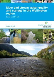
Take a No. 111 bus (Mon-Sat) to the end of Totara Park<br />
Road from Upper Hutt Railway Station<br />
Via Cannon Point Walkway: Bridge Rd (off <strong>Akatarawa</strong><br />
Rd); Tulsa Park or Valley View Road off Totara Park Rd,<br />
Upper Hutt<br />
Non-motorised visitors:<br />
Off SH 58:<br />
- Cooks Rd via Moonshine Rd and Bulls Run Rd<br />
- via Battle Hill Farm <strong>Forest</strong> Park, Paekakariki Hill Rd<br />
How to get there<br />
All visitors:<br />
Off SH2: Karapoti Rd via <strong>Akatarawa</strong> Rd, Upper Hutt<br />
Off SH1: Maungakotukutuku Rd, via Waterfall Rd 1km<br />
north of MacKays Crossing.<br />
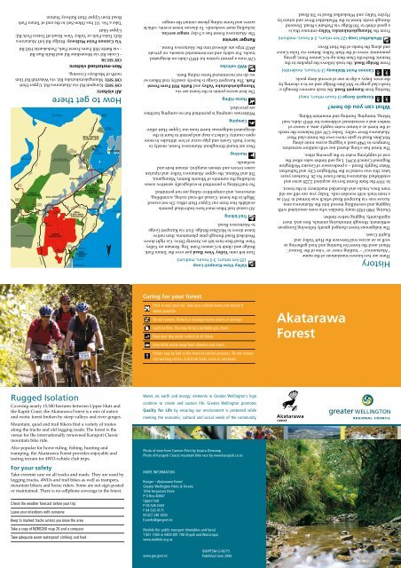
Rugged Isolation<br />
Covering nearly 15,500 hectares between Upper Hutt and<br />
the Kapiti Coast, the <strong>Akatarawa</strong> <strong>Forest</strong> is a mix of native<br />
and exotic forest broken by steep valleys and river gorges.<br />
Mountain, quad and trail bikers find a variety of routes<br />
along the tracks and old logging roads. The forest is the<br />
venue for the internationally renowned Karapoti Classic<br />
mountain bike ride.<br />
Also popular for horse riding, fishing, hunting and<br />
tramping, the <strong>Akatarawa</strong> <strong>Forest</strong> provides enjoyable and<br />
testing terrain for 4WD-vehicle club trips.<br />
For your safety<br />
Take extreme care on all tracks and roads. They are used by<br />
logging trucks, 4WDs and trail bikes as well as trampers,<br />
mountain bikers and horse riders. Some are not sign-posted<br />
or maintained. There is no cellphone coverage in the forest.<br />
Check the weather forecast before your trip<br />
Leave your intentions with someone<br />
Keep to marked tracks unless you know the area<br />
Take a copy of NZMS260 map 26 and a compass<br />
Take adequate warm waterproof clothing and food<br />
Ranger service<br />
The <strong>Akatarawa</strong> <strong>Forest</strong> has a 5-day ranger service,<br />
including most weekends. To discuss forest events, vehicle<br />
access and horse riding please contact the ranger.<br />
GW runs a permit system for 4WD clubs on designated<br />
tracks. For safety and environmental reasons, no private<br />
4WD trips are allowed into the <strong>Akatarawa</strong> <strong>Forest</strong>.<br />
Caring for your forest<br />
Pack in and pack out. Take your rubbish home and recycle it<br />
where possible.<br />
Do not remove, disturb or damage native plants or animals<br />
Light no fires. You may bring a portable gas stove<br />
Keep your dog under control at all times.<br />
Bury toilet waste away from streams and rivers.<br />
Poison may be laid in the forest to control possums. Do not remove<br />
any warning notice, or disturb baits, lures or carcasses.<br />
Water, air, earth and energy: elements in <strong>Greater</strong> <strong>Wellington</strong>’s logo<br />
combine to create and sustain life. <strong>Greater</strong> <strong>Wellington</strong> promotes<br />
Quality for Life by ensuring our environment is protected while<br />
meeting the economic, cultural and social needs of the community.<br />
Photo of view from Cannon Point by Jessica Dewsnap.<br />
Photo of Karapoti Classic mountain bike race by www.karapoti.co.nz<br />
MORE INFORMATION<br />
Ranger – <strong>Akatarawa</strong> <strong>Forest</strong><br />
<strong>Greater</strong> <strong>Wellington</strong> Parks & <strong>Forest</strong>s<br />
1056 Fergusson Drive<br />
P O Box 40847<br />
Upper Hutt<br />
P 04 526 5343<br />
F 04 526 4171<br />
M 027 248 1658<br />
E parks@gw.govt.nz<br />
Metlink (for public transport timetables and fares)<br />
T 801 7000 or 0800 801 700 (Kapiti and Wairarapa)<br />
www.metlink.org.nz<br />
www.gw.govt.nz<br />
GW/PFSM-G-06/75<br />
Published June 2006<br />
4WD vehicles<br />
The best access points to the forest are via<br />
Maungakotukutuku Valley and Battle Hill Farm <strong>Forest</strong><br />
Park. The Karapoti Gorge is heavily used by trail bikers so<br />
we do not recommend horse riding there.<br />
Horse riding<br />
Wilderness camping is permitted but no camping facilities<br />
are provided.<br />
Camping<br />
Deer are found throughout <strong>Akatarawa</strong> <strong>Forest</strong>, mostly in<br />
heavy bush. Goats and pigs occur at low altitudes in more<br />
open country. Collect a map and permit to hunt in the<br />
designated indigenous forest from our Upper Hutt office.<br />
Hunting<br />
No trail biking is permitted in ecologically sensitive zones<br />
including the summits of Mounts Barton, Maunganui,<br />
Titi and Wainui, the upper <strong>Akatarawa</strong> Valley and riparian<br />
zones (rivers and stream margins), stream beds and<br />
wetlands.<br />
All casual trail bikes must have individual permits<br />
available free from our Upper Hutt office. Do not exceed<br />
30kph in the forest. Casual off-road racing, scrambling,<br />
motocross, and competitive riding are not permitted.<br />
Trail biking<br />
Turn left onto Valley View Road just over the Totara Park<br />
Bridge and climb to Cannon Point Trig. Remain on Valley<br />
View Road then turn left on Airstrip Drive. Go right down<br />
Woolshed Road through pine plantations, then native<br />
forest down to McGhies Bridge. Exit via Karapoti Gorge<br />
to <strong>Akatarawa</strong> Road.<br />
Valley View-Karapoti Loop<br />
(25 km return, 3-5 hours, medium)<br />
From the Maungakotukutuku Valley entrance this is<br />
a good climb to Titi Ridge via Perham’s Road. Descend<br />
through exotic forest to the Whakatikei River and return by<br />
Hydro Valley and Whakatikei Road to Titi Road.<br />
Whakatikei Loop (22 km return, 2-4 hours, medium)<br />
From Bridge Road, the track follows the pipeline to the<br />
historic Birchville Dam then up to Cannon Point, giving<br />
panoramic views of the Hutt Valley. Return via Tulsa Grove<br />
and along the banks of the Hutt River.<br />
Cannon Point Walkway (3-4 hours, moderate)<br />
Starting from Karapoti Road, the track narrows through a<br />
bush-clad gorge to McGhies Bridge and on to a clearing by<br />
the river. Enjoy a dip in one of several deep pools.<br />
Karapoti Gorge (3 hours return, easy)<br />
The forest has a long shared use with outdoor recreation.<br />
Trampers in 1948 used a logging access route along<br />
McGhies Road to gain views over the forest-clad West<br />
<strong>Akatarawa</strong> River valley. Today GW still balances the needs<br />
of the forest as a future water supply area, a source of<br />
timber and a recreational wilderness for 4WD clubs, trail<br />
biking, tramping, hunting and mountain biking.<br />
In 1919 the State <strong>Forest</strong> Service acquired 2,228 acres and<br />
established <strong>Akatarawa</strong> State <strong>Forest</strong> No 26. Fourteen years<br />
later, this was vested in the <strong>Wellington</strong> City and Suburban<br />
Water Supply Board – a predecessor of <strong>Greater</strong> <strong>Wellington</strong><br />
<strong>Regional</strong> <strong>Council</strong> (GW). Log and timber sales offset the<br />
cost of supplying water to the growing cities.<br />
During 1900-1920 many families who were associated with<br />
logging and sawmilling moved into the <strong>Akatarawa</strong> area.<br />
Access was via Karapoti Road which was formed in 1911 as<br />
a tram track with wooden rails. Today you can still see old<br />
tram lines, trucks and discarded machinery in the forest.<br />
The indigenous forest changed greatly following European<br />
settlement, through introducing animals, fires and, most<br />
significantly, logging native timber.<br />
History<br />
There are two known translations of the name<br />
“Akataarawa” - ‘trailing vines’ or ‘vine of the Tarawa’.<br />
Maori used the forest for hunting and food gathering as<br />
well as an access trail between the Hutt Valley and<br />
Kapiti Coast.<br />
<strong>Akatarawa</strong><br />
<strong>Forest</strong><br />
What can you do here?
Paekakariki Hill Road<br />
Legend<br />
tracks<br />
vehicle<br />
foot<br />
Karapoti Classic<br />
Karapoti Challenge<br />
Cannon Point Walkway<br />
<strong>Akatarawa</strong> <strong>Forest</strong><br />
DoC Land<br />
Public<br />
Land<br />
Gate<br />
SH 1<br />
Battle Hill Farm<br />
<strong>Forest</strong> Park<br />
Abbott<br />
433m<br />
QUEEN<br />
ELIZABETH<br />
PARK<br />
Wainui<br />
722m<br />
Camping<br />
MACKAYS<br />
CROSSING<br />
Whareroa<br />
Farm<br />
(DoC)<br />
Puketiro Road<br />
Dog Walking<br />
Horse Riding<br />
Hunting<br />
RAUMATI<br />
Mountain Biking<br />
No Dogs<br />
Parking<br />
Toilets<br />
Trail Biking<br />
Tramping<br />
Walking<br />
<strong>Akatarawa</strong> <strong>Forest</strong><br />
Waterfall Road<br />
Maungakotukutuku Road<br />
PRIVATE<br />
LAND<br />
Cooks<br />
Road<br />
Moonshine<br />
Hydro Road<br />
Orange Hut<br />
Hydro Road<br />
Bull Run Road<br />
Road<br />
Perhams Road<br />
Whakatikei Road<br />
Toi Toi Road<br />
Cooks Road<br />
Copyright: <strong>Greater</strong> <strong>Wellington</strong> <strong>Regional</strong> <strong>Council</strong> Topographic and Cadastral data is copyright LINZ<br />
PRIVATE<br />
LAND<br />
Titi Road<br />
Norms Crossing<br />
528m<br />
Clearys Road<br />
Rimu Road<br />
Motocross Track<br />
The Duckpond<br />
State Highway 2<br />
Titi<br />
613m<br />
Maungakotukutuku Stream<br />
Dopers Creek<br />
Scenic<br />
Reserve<br />
(DoC)<br />
Maungakotukutuku<br />
Entrance<br />
Whakatikei River<br />
PRIVATE<br />
LAND<br />
Whakatikei River<br />
Hutt River<br />
Maunganui<br />
708m<br />
Pram Track<br />
457m<br />
McGhies<br />
Bridge<br />
McGhies Road<br />
Woolshed Road<br />
Airstrip Drive<br />
Valley View Road<br />
UPPER HUTT<br />
Rock<br />
Garden<br />
Devils<br />
Staircase<br />
<strong>Akatarawa</strong> <strong>Forest</strong><br />
Valley View Road<br />
<strong>Akatarawa</strong> River West<br />
Karapoti Gorge<br />
Valley View Road<br />
Cannon<br />
Point<br />
345m<br />
Tulsa<br />
Park<br />
Valley View<br />
Road Entrance<br />
Deadwood<br />
575m<br />
Hukinga Road<br />
Little <strong>Akatarawa</strong> River<br />
<strong>Akatarawa</strong> River West<br />
0 0.5 1 2 Kilometers<br />
PRIVATE<br />
LAND<br />
Birchville Dam<br />
Cannon Point Walkway<br />
Cedarholm<br />
Creek<br />
Barton<br />
627m<br />
Bridge<br />
Road<br />
<strong>Akatarawa</strong> River<br />
Karapoti<br />
Entrance<br />
<strong>Akatarawa</strong> Road