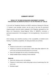
SUMMARY REPORT - MGB Region III
SUMMARY REPORT - MGB Region III
SUMMARY REPORT - MGB Region III

Create successful ePaper yourself
Turn your PDF publications into a flip-book with our unique Google optimized e-Paper software.
adjacent barangays and municipalities. Backflooding results from the inadequate<br />
drainage and exit points during unusually heavy rainy day and typhoon periods.<br />
Structurally controlled flooding such as elevated roads and road system with<br />
insufficient drainage, irrigation canals and excessive release of water from dams<br />
and temporary water impoundments are also common factors.<br />
• The agricultural areas/farm lots have a moderate to high susceptibility to flooding.<br />
• Localized flooding that usually subside after the rains can be attributed to<br />
inadequate drainage system during periods of unusually heavy precipitation.<br />
28. Municipality of Zaragosa<br />
• In terms of landslide susceptibility, no barangays in Zaragosa have the<br />
potential for landslide occurrence.<br />
• There are seven (7) barangays with moderate to high susceptibility to flooding<br />
(San Vicente, Carmen, Pantoc, Concepcion, San Isidro, Sta. Cruz and San<br />
Rafael).<br />
• There are twelve (12) barangays with high susceptibility to flooding. These<br />
barangays have portions that are adjacent to active creeks and river channel<br />
and are generally located in the low-lying areas (Sta. Lucia Young, Sta. Lucia<br />
Old, Del Pilar, Sto. Rosario Young, Sto. Rosario Old, Macarse, Mayamot,<br />
Veleriana, Batitang, Manaol, H. Romero and Gen. Luna).<br />
It should be noted that these susceptibility ratings were arrived at as of the field<br />
assessment. However the rating could advance (e.g., from low to moderate, moderate<br />
to high) due to changing physical conditions. Hence, the <strong>MGB</strong> constantly recommends<br />
strict and continuous monitoring of the affected barangays.<br />
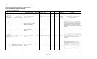
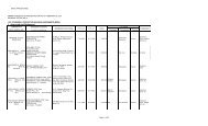
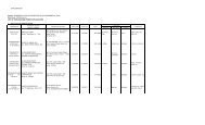
Attached herewith are the matrices of the municipalities included in the assessment.<br />
The geohazard assessment in the municipalities of Cabiao, Jaen, San Antonio and San<br />
Isidro was conducted in 2004-2005 during the Hazard Assessment along the Pampanga<br />
River. The location of the barangays was included in the geohazard data base. The<br />
data collected during this period was incorporated in the 1:50,000 Flood Susceptibility<br />
Map of the Province of Nueva Ecija.<br />
The hazard maps of Cabanatuan City and Palayan City was initially prepared by the<br />
<strong>MGB</strong>CO-UNDP 2005 and updated during this hazard mapping and assessment project.<br />
The location of the barangays was included in the geohazard data base. The data<br />
collected during this period was also incorporated in the 1:50,000 Flood Susceptibility<br />
Map of the Province of Nueva Ecija.<br />
19