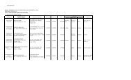
SUMMARY REPORT - MGB Region III
SUMMARY REPORT - MGB Region III
SUMMARY REPORT - MGB Region III

You also want an ePaper? Increase the reach of your titles
YUMPU automatically turns print PDFs into web optimized ePapers that Google loves.
Each barangay was rated into low, moderate or high for flooding susceptibility with the<br />
rating parameters as follows:<br />
Low<br />
• 0 – 0.5 meter depth of floodwaters<br />
Moderate<br />
• 0.51 – 1 meter depth of floodwaters<br />
High<br />
• > 1 meter depth of floodwaters<br />
With regards to landslide susceptibility, the barangays assessed include areas that are<br />
located on and/or near slopes and riverbanks and have the potential for landslide<br />
occurrence. The rating of each barangay presented herein particularly refers to the<br />
barangay proper since majority of the population is located there. It should be noted,<br />
however, that the rating does not necessarily reflect those of the sitios. These<br />
barangays were presented with a Landslide Threat Advisory informing their<br />
susceptibility to landslides and the corresponding recommendations particular to the<br />
barangay.<br />
The flood susceptibility of the barangays in the ten (10) municipalities/city was also<br />
assessed. Barangays classified with moderate to high susceptibility to flooding are<br />
located in identified low portions of the barangay, in topographically low-lying areas<br />
and/or near a major river system. These barangays were presented with a Geohazard<br />
Threat Advisory informing their susceptibility to flooding and the corresponding<br />
recommendations particular to the barangay.<br />
2