1515151515151515 15 Site 15 Lee Street (Meath Green) STW, Horley
1515151515151515 15 Site 15 Lee Street (Meath Green) STW, Horley
1515151515151515 15 Site 15 Lee Street (Meath Green) STW, Horley
- TAGS
- site
- street
- horley
- surreycc.gov.uk

Create successful ePaper yourself
Turn your PDF publications into a flip-book with our unique Google optimized e-Paper software.
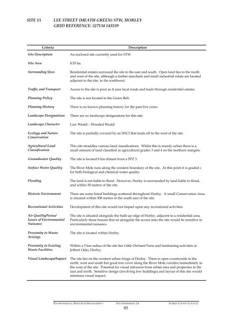
SITE <strong>15</strong> LEE STREET (MEATH GREEN) <strong>STW</strong>, HORLEY<br />
GRID REFERENCE: 527134 143559<br />
Criteria Description<br />
<strong>Site</strong> Description An enclosed site currently used for <strong>STW</strong>.<br />
<strong>Site</strong> Area 8.55 ha.<br />
Surrounding Uses Residential estates surround the site to the east and south. Open land lies to the north<br />
and west of the site, although a timber merchant and small industrial estate are located<br />
adjacent to the site, to the southwest.<br />
Traffic and Transport Access to the site is poor as it uses local roads and leads through residential estates.<br />
Planning Policy The site is not located in the <strong>Green</strong> Belt.<br />
Planning History There is no known planning history for the past five years.<br />
Landscape Designations<br />
Landscape Character<br />
Ecology and Nature<br />
Conservation<br />
Agricultural Land<br />
Classification<br />
There are no landscape designations for this site.<br />
Low Weald – Wooded Weald.<br />
The site is partially covered by an SNCI that leads off to the west of the site.<br />
This site straddles various land classifications. Whilst this is mainly urban there is a<br />
small amount of land classified as agricultural grades 3 and 4 on the northern margins.<br />
Groundwater Quality The site is located 8 km distant from a SPZ 3.<br />
Surface Water Quality The River Mole runs along the western boundary of the site. At this point it is graded c<br />
for both biological and chemical water quality.<br />
Flooding The land is not liable to flood. However, <strong>Horley</strong> is surrounded by land liable to flood,<br />
and within 50 metres of the site.<br />
Historic Environment There are some listed buildings scattered throughout <strong>Horley</strong>. A small Conservation Area<br />
is situated within 500 metres to the south east of the site.<br />
Recreational Activities Development of this site would not impact upon any recreational activities.<br />
Air Quality/Noise/<br />
Issues of Environmental<br />
Nuisance<br />
Proximity to Waste<br />
Arisings<br />
Proximity to Existing<br />
Waste Facilities<br />
The site is situated alongside the built up edge of <strong>Horley</strong>, adjacent to a residential area.<br />
Particularly those houses that sit alongside the access onto the site would be sensitive to<br />
environmental nuisance.<br />
The site is located within <strong>Horley</strong>.<br />
Within a 5 km radius of the site lies Little Orchard Farm and landraising activities at<br />
Jethart Oaks, <strong>Horley</strong>.<br />
Visual Landscape/Impact The site lies on the western urban fringe of <strong>Horley</strong>. There is open countryside to the<br />
north, west and south but good tree cover along the River Mole corridor immediately to<br />
the west of the site. Potential for visual intrusion from urban area and properties to the<br />
east and north. Sensitive design (involving low buildings) and layout of this site would<br />
minimise visual impact.<br />
ENVIRONMENTAL RESOURCES MANAGEMENT SITE ASSESSMENT 2A SURREY COUNTY COUNCIL<br />
85