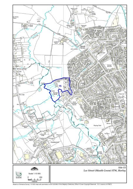
1515151515151515 15 Site 15 Lee Street (Meath Green) STW, Horley
1515151515151515 15 Site 15 Lee Street (Meath Green) STW, Horley
1515151515151515 15 Site 15 Lee Street (Meath Green) STW, Horley
- TAGS
- site
- street
- horley
- surreycc.gov.uk

Create successful ePaper yourself
Turn your PDF publications into a flip-book with our unique Google optimized e-Paper software.
�<br />
Scale 1:10 000<br />
0 200<br />
metres<br />
<strong>15</strong><br />
<strong>15</strong><br />
<strong>Site</strong> <strong>15</strong><br />
<strong>Lee</strong> <strong>Street</strong> (<strong>Meath</strong> <strong>Green</strong>) <strong>STW</strong>, <strong>Horley</strong><br />
Based on Ordnance Survey 1:10 000 maps with permission of the controller of Her Majesty's Stationery Office © Crown Copyright Reserved. O.S. Licence LA 076872
SITE <strong>15</strong> LEE STREET (MEATH GREEN) <strong>STW</strong>, HORLEY<br />
GRID REFERENCE: 527134 143559<br />
Criteria Description<br />
<strong>Site</strong> Description An enclosed site currently used for <strong>STW</strong>.<br />
<strong>Site</strong> Area 8.55 ha.<br />
Surrounding Uses Residential estates surround the site to the east and south. Open land lies to the north<br />
and west of the site, although a timber merchant and small industrial estate are located<br />
adjacent to the site, to the southwest.<br />
Traffic and Transport Access to the site is poor as it uses local roads and leads through residential estates.<br />
Planning Policy The site is not located in the <strong>Green</strong> Belt.<br />
Planning History There is no known planning history for the past five years.<br />
Landscape Designations<br />
Landscape Character<br />
Ecology and Nature<br />
Conservation<br />
Agricultural Land<br />
Classification<br />
There are no landscape designations for this site.<br />
Low Weald – Wooded Weald.<br />
The site is partially covered by an SNCI that leads off to the west of the site.<br />
This site straddles various land classifications. Whilst this is mainly urban there is a<br />
small amount of land classified as agricultural grades 3 and 4 on the northern margins.<br />
Groundwater Quality The site is located 8 km distant from a SPZ 3.<br />
Surface Water Quality The River Mole runs along the western boundary of the site. At this point it is graded c<br />
for both biological and chemical water quality.<br />
Flooding The land is not liable to flood. However, <strong>Horley</strong> is surrounded by land liable to flood,<br />
and within 50 metres of the site.<br />
Historic Environment There are some listed buildings scattered throughout <strong>Horley</strong>. A small Conservation Area<br />
is situated within 500 metres to the south east of the site.<br />
Recreational Activities Development of this site would not impact upon any recreational activities.<br />
Air Quality/Noise/<br />
Issues of Environmental<br />
Nuisance<br />
Proximity to Waste<br />
Arisings<br />
Proximity to Existing<br />
Waste Facilities<br />
The site is situated alongside the built up edge of <strong>Horley</strong>, adjacent to a residential area.<br />
Particularly those houses that sit alongside the access onto the site would be sensitive to<br />
environmental nuisance.<br />
The site is located within <strong>Horley</strong>.<br />
Within a 5 km radius of the site lies Little Orchard Farm and landraising activities at<br />
Jethart Oaks, <strong>Horley</strong>.<br />
Visual Landscape/Impact The site lies on the western urban fringe of <strong>Horley</strong>. There is open countryside to the<br />
north, west and south but good tree cover along the River Mole corridor immediately to<br />
the west of the site. Potential for visual intrusion from urban area and properties to the<br />
east and north. Sensitive design (involving low buildings) and layout of this site would<br />
minimise visual impact.<br />
ENVIRONMENTAL RESOURCES MANAGEMENT SITE ASSESSMENT 2A SURREY COUNTY COUNCIL<br />
85
<strong>Site</strong> <strong>15</strong> <strong>Lee</strong> <strong>Street</strong> (<strong>Meath</strong> <strong>Green</strong>) <strong>STW</strong>, <strong>Horley</strong><br />
Preliminary Conclusions<br />
.1 The site is currently operating as a sewage treatment works, and Thames<br />
Water Utilities have indicated that they are looking to relocate the operations.<br />
The access road (<strong>Lee</strong> <strong>Street</strong>) leads through a residential area, and housing is<br />
situated particularly close to the site access. ERM considers that the site’s<br />
proximity to housing, and poor access represent serious constraints to<br />
development at this site. There are no plans for a bypass around <strong>Horley</strong>, and<br />
it is difficult to see how an alternative access arrangement could be provided.<br />
ERM consider this site is unsuitable for promotion for waste development.<br />
Figure <strong>15</strong>.1 <strong>Lee</strong> <strong>Street</strong> (<strong>Meath</strong> <strong>Green</strong>) <strong>STW</strong>, <strong>Horley</strong><br />
ENVIRONMENTAL RESOURCES MANAGEMENT SITE ASSESSMENT 2A SURREY COUNTY COUNCIL<br />
86
ENVIRONMENTAL RESOURCES MANAGEMENT SITE ASSESSMENT 2A SURREY COUNTY COUNCIL<br />
87
�<br />
Scale 1:10 000<br />
0 200<br />
metres<br />
16b<br />
16b<br />
16c<br />
16c<br />
16a<br />
16a<br />
<strong>Site</strong> 16a<br />
Lyne Lane Chertsey: CA <strong>Site</strong><br />
Based on Ordnance Survey 1:10 000 maps with permission of the controller of Her Majesty's Stationery Office © Crown Copyright Reserved. O.S. Licence LA 076872
SITE 16a LYNE LANE, CHERTSEY: CA SITE - GRID REFERENCE: 501696 167293<br />
Criteria Description<br />
<strong>Site</strong> Description An existing CA site developed on land previously used for sewage treatment works.<br />
<strong>Site</strong> Area 0.23 ha.<br />
Surrounding Uses The <strong>STW</strong> occupies the adjacent site to the north, and beyond that is a temporary compost<br />
facility. A large motorway junction lies north of the site, as the M25 runs north/south,<br />
and the M3 runs east/west. South of the site is a railway line, beyond which is open<br />
countryside and scattered houses.<br />
Traffic and Transport Access could be gained via the adjacent railway (branch line). This line may be affected<br />
by the ‘Airtrack’ proposal that is currently being considered by Railtrack.<br />
Road access to the site from the north is acceptable. Heavy vehicles should not be<br />
encouraged to access the site via Lyne Lane to the south. Development in association with<br />
adjacent sites may lead to a cumulative transport impact.<br />
Planning Policy The site is located in the <strong>Green</strong> Belt.<br />
Planning History The site has planning permission for use of the land as a civic amenity site, for lighting on<br />
site and for a storage bay to receive green wastes.<br />
Landscape Designations<br />
Landscape Character<br />
Ecology and Nature<br />
Conservation<br />
Agricultural Land<br />
Classification<br />
There are no landscape designations for this site.<br />
Thames Basin Heaths – Western Surrey.<br />
Ancient woodland lies approximately 300 metres to the east and further afield to the<br />
south. Land designated as Ramsar, the SW London Waterbodies SPA and SNCI is<br />
situated 800 metres to the northeast.<br />
This site is on land classified as agricultural grade 2. However, the site is already<br />
developed.<br />
Groundwater Quality The site is approximately 1 km distant from a SPZ.<br />
Surface Water Quality The Bourne lies approximately 700 metres to the north. At this point it is grade c for<br />
biological water quality and grade b for chemical water quality. Development of this site<br />
is unlikely to significantly affect water quality.<br />
Flooding Land liable to flood is situated approximately 300 metres to the north and west of the site.<br />
Historic Environment There are various SMRs within 500 metres of the site. There is an historic park<br />
approximately 500m to the southeast. Thorpe Conservation Area is located some<br />
distance to the northeast.<br />
Recreational Activities Development of this site would not impact upon any recreational activities.<br />
Air Quality/Noise/<br />
Issues of Environmental<br />
Nuisance<br />
Proximity to Waste<br />
Arisings<br />
Proximity to Existing<br />
Waste Facilities<br />
The site is located in an area of open countryside. However, it is also situated alongside a<br />
motorway interchange, the M25 and railway line. The site is adjacent to Runnymede<br />
AQMA 2, which follows a section of the M25.<br />
Weybridge is approximately 10 km distant. Egham is approximately 6 km distant.<br />
Within a 5 km radius lie the <strong>STW</strong> and the Lyne Lane compost facility on the opposite side<br />
of the road.<br />
ENVIRONMENTAL RESOURCES MANAGEMENT SITE ASSESSMENT 2A SURREY COUNTY COUNCIL<br />
89
Criteria Description<br />
Visual Landscape/Impact The existing CA site is not considered to result in a significant landscape impact. The<br />
area is well wooded to the west but otherwise is quite open. An important landmark is<br />
St Anne’s Hill to the east, beyond the M25. Further development could cause a potential<br />
visual impact upon the hamlet of Lyne to the south and individual properties between –<br />
screening would be required.<br />
<strong>Site</strong> 16a Lyne Lane, Chertsey: CA site<br />
Preliminary Conclusions<br />
.1 This site currently occupies a CA site operated by Surrey Waste<br />
Management, and is running to capacity. If land at the adjacent <strong>STW</strong> (<strong>Site</strong> 16c)<br />
became available this would provide an ideal site on which to expand the<br />
service already provided. However in itself, this site is not considered to offer<br />
potential for any further development.<br />
.2 The ‘Airtrack’ proposal would extend the Heathrow Express Line and<br />
Terminal 5 link into the Surrey rail network. As such, the status of the branch<br />
line adjacent to Lyne Lane would be expected to change. Although these<br />
proposals are by no means certain to go ahead, there could be a conflict<br />
between high speed passenger trains and slower freight trains that would be<br />
associated with any waste development. On its own, this site is unlikely to be<br />
attractive for rail freight; this would become a more pertinent issue if the site<br />
were redeveloped in conjunction with <strong>Site</strong> 16c.<br />
Figure 16a.1 Lyne Lane, Chertsey: CA <strong>Site</strong><br />
ENVIRONMENTAL RESOURCES MANAGEMENT SITE ASSESSMENT 2A SURREY COUNTY COUNCIL<br />
90
ENVIRONMENTAL RESOURCES MANAGEMENT SITE ASSESSMENT 2A SURREY COUNTY COUNCIL<br />
91