

Download (3998Kb)
Download (3998Kb)
Download (3998Kb)
- TAGS
- download
- nora.nerc.ac.uk

Create successful ePaper yourself
Turn your PDF publications into a flip-book with our unique Google optimized e-Paper software.
Revealing deep structural influences on the Upper Cretaceous Chalk of East<br />
Anglia (UK) through inter-regional geophysical log correlations<br />
M. A. Woods a, * , B. C. Chacksfield b<br />
a: British Geological Survey, Keyworth, Nottingham NG12 5GG, UK<br />
b: formerly British Geological Survey<br />
*: Corresponding author. Tel.: +44 (0) 115 9363155.<br />
E-mail address: maw@bgs.ac.uk<br />
Abstract<br />
New borehole geophysical log interpretations between Wiltshire and north Norfolk<br />
show detailed lateral changes in the spatial relationships of Chalk Group marker beds.<br />
They show how marker beds in the Turonian and Coniacian Chalk Group in East<br />
Anglia pass laterally into their correlatives further west, and reveal unusual lateral<br />
thickness changes affecting stratigraphical intervals in the East Anglian succession.<br />
Newly enhanced regional gravity and magnetic data indicate that these thickness<br />
changes are probably related to WNW to ESE trending structural lineaments in the<br />
Palaeozoic basement rocks of the buried Anglo-Brabant Massif.<br />
The later part of the Mid Turonian and early part of the Late Turonian succession<br />
across East Anglia is greatly thickened, and shows almost no lateral variability. These<br />
relatively soft, smooth-textured chalks equate with thinner, hard, nodular beds formed<br />
in both shallow marine and deeper basinal settings elsewhere in southern England.<br />
Since it seems unlikely that there was greater sediment accommodation space across<br />
East Anglia at this time compared to basinal areas, this thickening may reflect a<br />
localised coccoliths productivity pulse, or perhaps a sheltered palaeogeographical<br />
position that protected the area from sediment-winnowing marine currents.<br />
A residual gravity low across north Norfolk, previously interpreted as a granite<br />
pluton, may instead represent two elongated (?fault-bounded) sedimentary basins.<br />
Keywords: Chalk, Upper Cretaceous, geophysical logs, structure, gravity, magnetic<br />
1. Introduction<br />
The Upper Cretaceous Chalk Group of the United Kingdom can be subdivided into<br />
three broad depositional provinces defined by differences in lithology and fauna<br />
(Mortimore, 1983; Mortimore et al., 2001). Whilst the successions of southern<br />
England (Southern Province) and northern England (Northern Province) are relatively<br />
well understood, this is not true of the Chalk of East Anglia (Fig. 1), which largely<br />
belongs to the Transitional Province (Mortimore et al., 2001). The East Anglian chalk<br />
succession (Fig. 2) is laterally contiguous with that of the Chilterns, Berkshire,<br />
Marlborough and Wiltshire downs, areas that also belong to the Transitional Province.<br />
Recent remapping of the Thetford district (England & Wales 1:50 000 geological<br />
sheet 174) by the British Geological Survey (BGS) demonstrated the paucity of inland<br />
1
exposure of the Chalk that is typical of East Anglia. Historical data for the Chalk of<br />
the region are biased towards biostratigraphy and provide limited understanding of<br />
vertical and lateral lithofacies patterns. In contrast, there has been little exploitation of<br />
borehole geophysical log data and regional gravity and magnetic data.<br />
2. Previous Research<br />
In East Anglia, lack of exposure meant that historical work on the Chalk mainly<br />
focused on biozonal mapping, an approach best exemplified by Peake and Hancock<br />
(1970). Since publication of this work, about 90% of the chalk pits upon which it was<br />
based have been infilled (Peake and Hancock, 2000a, b). Whilst there has been great<br />
progress in the development of lithostratigraphy schemes for the Chalk in northern<br />
and southern England (Bristow et al., 1997; Gale, 1995, 1996; Jarvis and Woodroof,<br />
1984; Mortimore, 1986; Mortimore and Pomerol, 1987, Mortimore et al., 2001;<br />
Robinson, 1986; Whitham, 1991, 1993; Wood and Smith, 1978), with agreement of a<br />
broad stratigraphical framework (Rawson et al., 2001), East Anglia remains poorly<br />
understood (Fig. 2).<br />
Work on the use of borehole geophysical logs for correlation in the Chalk Group<br />
began in the 1950s and 60s, with the identification of marker-bands on the resistivity<br />
log of the BGS Leatherhead (Fetcham Mill) Borehole, Surrey [TQ 1518 5650] (Gray<br />
1958, 1965). Murray (1986) subsequently used these marker-bands to correlate<br />
Cenomanian and Turonian successions from the London Basin to East Yorkshire, and<br />
more recent log interpretations have recognised the new formational and marker bed<br />
stratigraphy of the Chalk Group (Mortimore and Wood, 1986; Mortimore and<br />
Pomerol, 1987; Woods and Aldiss, 2004; Woods, 2006).<br />
At the beginning of the BGS work in the Thetford district there was comprehensive<br />
reinvestigation of relevant borehole and outcrop biostratigraphical data. The area<br />
fortuitously has a wide cover of borehole geophysical log data, as well as numerous<br />
borehole observations at Mundford related to a site investigation for a large proton<br />
accelerator (Ward et al., 1968; Fig. 1).<br />
3. Borehole geophysical log data<br />
At first sight, the correlation of key borehole geophysical logs in the Chalk of the<br />
Thetford district looks unremarkable (Fig. 3). Understanding its significance is only<br />
possible in the wider context of coeval successions, revealed through interpretation of<br />
borehole geophysical logs for the broader Transitional Province extending westwards<br />
to Berkshire and Wiltshire (Figs 4, 5). Details of the basis for borehole geophysical<br />
log correlations in the Chalk are given in Woods and Aldiss (2004) and Woods<br />
(2006).<br />
3.1. Borehole geophysical log correlation across the Transitional Province<br />
Figures 4 and 5 show the correlation of borehole geophysical logs across the<br />
Transitional Province for Cenomanian to Coniacian strata. Beginning in the far west,<br />
core from the Everleigh Borehole allows stratigraphical calibration of its resistivity<br />
and gamma logs. The Plenus Marls form a low resistivity spike at the base of the<br />
Holywell Nodular Chalk Formation, overlain by higher resistivity log values<br />
2
eflecting the typically hard chalk of this formation. The softer New Pit Chalk<br />
corresponds with lower resistivity log values; at Everleigh this formation is relatively<br />
thin due to erosion and/or condensed sedimentation associated with the lowest<br />
hardground of the immediately overlying Chalk Rock (Gale, 1996; Woods and Aldiss,<br />
2004). These hardgrounds are marked by sharply defined high resistivity log peaks.<br />
The interpretation of the Everleigh Borehole is easily extrapolated to logs for<br />
boreholes at Horsehall Hill and Banterwick Barn (No. 2), the core from the latter<br />
providing further control for correlations (Woods and Aldiss, 2004). The New Pit<br />
Chalk is more expanded at Banterwick, with the development of the Glynde Marls at<br />
the top of the formation, and the base of the Chalk Rock is also relatively younger.<br />
From Banterwick to Braughing/Hamels Mill there is progressive eastward expansion<br />
of the New Pit Chalk. Control for these correlations is provided by a group of<br />
distinctive low resistivity spikes (‘C’ on Fig. 4) in the New Pit Chalk, and by the<br />
sharply defined low resistivity spike formed by Southerham Marl 1 in the basal part of<br />
the Lewes Nodular Chalk. Marker ‘C’ in part corresponds with the ‘marker marls’ of<br />
Woods and Aldiss (2004) and Woods (2006, fig. 7), the highest of these low<br />
resistivity inflections probably representing the Round Down Marl of Robinson<br />
(1986) (= Malling Street Marl of Mortimore (1986); Mortimore et al., 2001, p. 314)<br />
(Pearce et al., 2003). North-eastwards into East Anglia, marker ‘C’ becomes difficult<br />
to trace (Figs 3, 5), and the succession below the Pilgrims’ Walk Marl contains the<br />
Methwold and Denton Lodge marls (Ward et al., 1968, fig. 3; Murray, 1986, fig. 11;<br />
Figs 3, 4, 5). The detailed correlation of this interval is poorly understood.<br />
From Slough eastwards the Lewes Nodular Chalk shows the development of another<br />
high resistivity peak, interpreted as the Top Rock based on the Thundridge Borehole<br />
(Wood, 1986) and the Baldock Bypass succession (Fig. 4). The Top Rock is a<br />
hardground that locally condenses the greater part of the Micraster cortestudinarium<br />
Zone (Fig. 2; Wood, 1986). The correlation between Baldock Bypass and Great<br />
Chishill is relatively straightforward. In these boreholes two strong gamma peaks<br />
represent the Top Rock and Chalk Rock, and below these, the probable correlative of<br />
Southerham Marl 1 is developed as a sharp high gamma peak. Lower down in the<br />
Great Chishill succession, a series of high gamma peaks probably corresponds to the<br />
Glynde Marls at Baldock Bypass; the lowest of the Glynde Marls at Baldock equates<br />
with a broad high gamma peak and sharp low resistivity spike in the Great Chishill<br />
succession. Slightly lower in the Great Chishill Borehole, the probable horizon of the<br />
New Pit Marls (seen at outcrop in the Baldock Bypass section) corresponds with a<br />
zone of high gamma peaks and low resistivity spikes. Although the spacing of these<br />
markers at Great Chishill is slightly expanded compared to Baldock Bypass, the<br />
correlation and stratigraphical trend are confirmed by the group of low resistivity<br />
spikes labelled ‘C’ on Figure 4 (see above).<br />
Boreholes between Great Chishill and Great Bradley are critical in providing a link<br />
with the East Anglia succession, and the remainder of the interpretation presented on<br />
Figure 4 is best understood by working westwards from Great Bradley towards Great<br />
Chishill.<br />
The resistivity log of the Great Bradley Borehole is easily matched with published<br />
logs showing the Turonian marl seam stratigraphy in East Anglia, as exemplified by<br />
the North Pickenham Borehole (Mortimore and Wood,1986, fig. 2.6), and allows<br />
3
identification of the Pilgrims’ Walk Marl, Mount Ephraim Marl, Twin Marl and<br />
Grimes Graves Marl. The Great Bradley log also shows high resistivity peaks<br />
corresponding with the Chalk Rock and Top Rock. These horizons can be<br />
extrapolated westwards into the Haverhill and Westoe Farm boreholes. In the Westoe<br />
Farm succession, the Chalk Rock is indicated by a strong gamma and less prominent<br />
resistivity peak; a lower, more pronounced resistivity peak has a subdued gamma<br />
signature, and probably represents a development of the flint-rich Brandon Flint<br />
Series, which is typically associated with the Grimes Graves Marl in East Anglia.<br />
Previously published correlations of the East Anglian marl seams provide the link<br />
between the different marl seam nomenclatures extrapolated into the Westoe Farm<br />
and Great Chishill boreholes. These correlations demonstrate the following<br />
equivalences: Pilgrims’ Walk Marl = Glynde Marls; Mount Ephraim Marl =<br />
Southerham Marl 1; Twin Marl = Caburn Marl (Mortimore and Wood, 1986). Based<br />
on these interpretations, borehole correlations between Great Chishill and Westow<br />
Farm show that strata equivalent to the lower part of the Lewes Nodular Chalk<br />
become markedly expanded eastwards into East Anglia. On resistivity logs, the<br />
signature of these strata merges with that of the underlying New Pit Chalk, suggesting<br />
a reduction in primary cementation. Expansion of the lower Lewes Nodular Chalk is<br />
accompanied by corresponding thinning of the underlying New Pit Chalk. The partial<br />
resistivity logs for the boreholes at Hempstead and Armitage Bridge allow clear<br />
correlation of the Chalk Rock and Top Rock, but interpretation of the Southerham<br />
Marl 1 is more speculative.<br />
From Great Bradley north-eastwards, the Pilgrims’ Walk, Mount Ephraim and Twin<br />
Marls are a distinctive group of low resistivity log inflections (Fig. 4) that were used<br />
by Pattison et al. (1993) to correlate boreholes along the Essex-Suffolk border near<br />
Sudbury. Stratigraphical control is provided by the cored Stowlangtoft Borehole<br />
(Bristow, 1990), the published interpretation for the North Pickenham Borehole<br />
(Mortimore and Wood, 1986), and the cored succession in Borehole 2X at Bircham<br />
(Moorlock et al., 2008). Recognition of the Chalk Rock is problematic in some<br />
boreholes, especially north of Stowlangtoft where the flint-rich Brandon Flint Series<br />
forms a high resistivity peak. Here, identification of the Chalk Rock is aided by<br />
interpretation of adjacent marker-beds.<br />
Between the Westoe Farm and Stowlangtoft boreholes there is dramatic thinning<br />
between the Mount Ephraim Marl and Plenus Marls (Fig. 5), which is not (as<br />
previously) compensated for by further expansion of the lower part of the Lewes<br />
Nodular Chalk. This condensed pattern persists northwards across East Anglia<br />
(including the Thetford district; Fig. 3), with further slight thinning in the East<br />
Harling Borehole. There is also some slight thinning of the high resistivity interval<br />
above the Plenus Marls (equivalent to the Holywell Nodular Chalk), but based on the<br />
apparent persistence of the distinctive log inflection formed by the Pilgrims’ Walk<br />
Marl, much of the thinning appears to affect strata equivalent to the New Pit Chalk.<br />
In northern East Anglia, the core and geophysical logs for the Bircham 2X Borehole<br />
clearly demonstrate significant northward thinning of the interval between the base of<br />
the Chalk and the Plenus Marls compared to the Stowlangtoft Borehole; the<br />
succession between the Plenus Marls and Grimes Graves Marl is similarly but less<br />
dramatically attenuated.<br />
4
3.2. Borehole geophysical log correlation across the Thetford district<br />
The above interpretations show that dramatic lateral changes in Chalk sedimentation<br />
in East Anglia are not clearly reflected by the persistent marker-bed stratigraphy<br />
shown by borehole correlations across the Thetford district (Fig. 3). In addition to the<br />
greatly thinned equivalent of the New Pit Chalk and expanded equivalent of the lower<br />
Lewes Nodular Chalk, boreholes from the Thetford district also show:<br />
(i) Unusual local thinning of the interval between the Chalk Rock and Top Rock<br />
at Mundford<br />
(ii) Eastward expansion of the Top Rock, between Mundford and East Harling,<br />
into discrete stratigraphical units, the highest locally strengthening into a<br />
significant hardground in the Square Plantation and East Harling boreholes.<br />
.<br />
4. Lithological data<br />
Despite poor exposure, there are some lithological data that support geophysical<br />
evidence for significant lateral changes in Turonian and Coniacian Chalk stratigraphy<br />
in East Anglia. The Stowlangtoft Borehole contains an erosion surface with chalk<br />
pebbles in the unusually thin equivalent of the New Pit Chalk (largely equating with<br />
the interval between the Methwold Marl and Pilgrims’ Walk Marl; Figs 2, 4, 5), with<br />
a further erosion surface a short distance above the Pilgrims’ Walk Marl (Wood and<br />
Bristow 1990). Strongly indurated chalk a few metres below the Pilgrims’ Walk Marl<br />
at 142.79 m, possibly also represents a hardground.<br />
In the Ely-Ouse Borehole 2 [TL 7008 6976], the lowest 20 m of the T. lata Zone,<br />
immediately above shell-rich chalk inferred to equate with the Holywell Nodular<br />
Chalk Formation, contains common horizons of large (50 – 100 mm) green and buffcoated<br />
nodules (Wood and Bristow,1990, p. 21). These records suggest the presence<br />
of mineralised hardgrounds and erosion surfaces with glauconite and phosphate, and<br />
are below the expected horizon of the Chalk Rock and Top Rock at which levels these<br />
features might otherwise be expected.<br />
Finally, digital video log evidence from the Brandon Satellite Borehole (Fig. 6) shows<br />
that marl seams in the upper part of the succession are sheared along inclined fracture<br />
surfaces, some with listric form based on their digital video log geometry. These<br />
probably indicate post-depositional disruption of the succession, but lower down<br />
(below the Pilgrims’ Walk Marl) disrupted bands of flint nodules around 45 m and 48<br />
m depth might reflect syndepositional tectonic processes, since adjacent marl and flint<br />
markers are unaffected.<br />
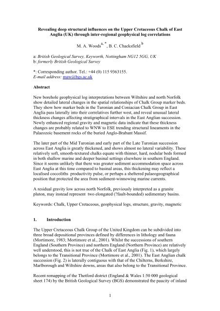
5. Regional gravity and magnetic data<br />
The BGS has digital regional gravity and aeromagnetic data for most of the United<br />
Kingdom, including the current study area. These data have been used to compile the<br />
1:625 000 scale gravity and magnetic maps of the UK (British Geological Survey,<br />
2007a, b). Although regional gravity and magnetic data have been previously<br />
discussed and interpreted in the context of deep basement structure (Lee et al., 1990,<br />
5
1993; Busby and Smith, 2001; Busby et al., 1993, 2006), they have not hitherto been<br />
used to understand patterns of Mesozoic sedimentation in East Anglia.<br />
Figure 7 shows a colour shaded relief residual Bouguer gravity anomaly map with the<br />
key borehole locations plotted; Figure 8 shows the same boreholes plotted on a<br />
greyscale shaded relief version of the residual Bouguer gravity anomaly map, overlain<br />
by a flat colour reduced–to–pole magnetic anomaly map. In both figures the data have<br />
been considerably enhanced by reprocessing, and are much refined compared to that<br />
previously published. The residual gravity anomaly map was generated by upwardly<br />
continuing the regional gravity field to 2 km and then removing this field from the<br />
observed anomaly; this enhances lateral density variations in the crust attributed to<br />
geological sources at shallow depths. The reduced–to–pole magnetic anomaly is the<br />
measured Total Field anomaly converted to the field that would be observed at the<br />
magnetic pole (vertical field). This has the advantage of simplifying the anomaly<br />
pattern and adjusting the location of the anomaly peak to lie immediately over the<br />
source.<br />
The residual gravity map shows a prominent structural trend beneath the Chalk<br />
outcrop of the central part of East Anglia which is predominantly WNW – ESE. This<br />
trend reflects basement structures within the eastern England Caledonide fold belt that<br />
forms part of the Anglo-Brabant Massif. Towards the north Norfolk coast the<br />
structural trend becomes more fragmented and progressively more E – W in nature.<br />
Gravity lows across East Anglia have been modelled primarily as low density<br />
Devonian sedimentary basins beneath the Cretaceous (Busby and Smith, 2001).<br />
Where these rocks are thin or absent, gravity highs associated with higher density<br />
basement rocks generally prevail. In The Wash area, a series of gravity lows with<br />
magnetic highs around their margins (Figs 7, 8) are thought to relate to granite<br />
intrusions.<br />
In the Thames Valley region of southern England relatively dense basement rocks<br />
make up the London Platform that forms part of the Midlands Microcraton; this is<br />
characterised by a gravity pattern that has no strong linear trends in contrast to the<br />
East Anglia region. Over the Midlands Microcraton a series of residual gravity lows<br />
are present that are associated with important sedimentary basins including the<br />
concealed Berkshire and Oxfordshire coalfields. The Midlands Microcraton lies<br />
within a broad regional magnetic high whose source is modelled as magnetic,<br />
Precambrian Avalonian basement (Busby and Smith, 2001).<br />
The eastern limit of the Midlands Microcraton is poorly defined on the gravity map<br />
and its location is very approximate. The broad magnetic anomaly appears to continue<br />
beyond the presently mapped eastern limit of the Midlands Microcraton where a<br />
broad residual gravity low is also present. This low has been modelled as a thickening<br />
sequence of Lower Palaeozoic metasedimentary rocks within a higher density<br />
basement, locally overlain by low density Devonian deposits (Busby and Smith,<br />
2001).<br />
The southern margin of the Midlands Microcraton is bounded by the Variscan Front.<br />
On the gravity map this is clearly shown as an arcuate E – W belt of gravity<br />
anomalies, representing the northern limit of Variscan thrusting over the foreland. The<br />
6
accepted margin of the Variscan Front based on borehole and seismic data is shown<br />
on the magnetic map. The new residual gravity map and gravity modelling (Busby<br />
and Smith, 2001), however, suggests that in the Thames Estuary region the margin of<br />
the Variscan Front probably lies further to the north.<br />
There appear to be several clear spatial relationships between the regional geophysical<br />
data and stratigraphical changes in the Turonian and Coniacian Chalk of East Anglia:<br />
(1) Thinning above the Holywell Nodular Chalk between the<br />
Westoe Farm Borehole and the Stowlangtoft Borehole<br />
(Fig. 5) spans a major WNW – ESE orientated gravity lineament<br />
(‘L1’ of Fig. 7).<br />
(2) The Mundford site investigation area, with its unusually thin Chalk<br />
Rock to Top Rock interval, occupies part of a large gravity high,<br />
bounded on its south-west margin by the pronounced gravity lineament<br />
described in (1) above.<br />
(3) Regional thinning of the New Pit Chalk and thickening of the lower<br />
part of the Lewes Nodular Chalk begins close to the inferred eastern<br />
margin of the Midlands Microcraton (Figs 4, 8).<br />
(4) The interval between the Chalk Rock and Top Rock thins close to the<br />
north-east margin of the Midlands Microcraton (Figs 4, 8). South-west<br />
and north-east of this boundary there is expansion of the interval.<br />
(5) Ely-Ouse Borehole 2, with evidence of Early Turonian mineralised<br />
hardgrounds and erosion surfaces, is located close to the major WNW<br />
– ESE gravity lineament discussed in (1) (above).<br />
The relationship between the regional geophysical data and boreholes with expanded<br />
successions between the Chalk Rock and local ‘Top Rock’ is less clear. Some of these<br />
boreholes occupy gravity highs (East Harling, Kenninghall Water Tower), and some<br />
gravity lows (Square Plantation) (Fig. 7), but all are coincident with a small positive<br />
magnetic anomaly (‘MH8’ of Lee et al., 1991, fig. 8) extending north-westwards<br />
beyond the East Anglia region (Fig. 8). This magnetic feature is interpreted as<br />
probably representing a mid crustal block of more magnetic rocks (Busby et al.,<br />
1993), and it is possible that the gravity features may directly relate to structures<br />
associated with this and have no significance for Mesozoic sedimentation.<br />
Gravity lineament ‘L1’ on Figure 7 is a major, low angle, north-east dipping thrust<br />
fault, named the Glinton Thrust (Chadwick and Evans, 2005). The fault is possibly of<br />
Late Ordovician age, and near Peterborough juxtaposes Late Precambrian and<br />
?Cambrian rocks in the hanging wall (forming the gravity high north-east of the<br />
lineament) against Ordovician rocks in its footwall (forming the gravity low<br />
immediately south-west of the lineament). The post-Palaeozoic history of this<br />
structure is not known in any detail, but the possibility of reactivation during Variscan<br />
and Alpine compression and Mesozoic extension has been acknowledged (Chadwick<br />
and Evans, 2005). South of the thrust lineament, Figure 7 shows a series of<br />
subparallel ESE – WNW gravity features, cut by some sharp NNW – SSE features.<br />
7
These may be part of a complex structural fabric, possibly an imbricate thrust stack,<br />
associated with the development of the Glinton Thrust. More enigmatic is the narrow<br />
NNE – SSW gravity high labelled ‘A1’ on Figure 7. The orientation of this feature is<br />
orthogonal to the regional grain, and it may represent a relay fault developed behind<br />
the leading edge of the Glinton Thrust. It is not known if this structure was involved<br />
in later reactivation, but such structures might cause structural compartmentalisation<br />
of thrusts and affect how different parts of them respond to later movement.<br />
Finally, an elongated mass of granite has previously been speculated to occur at depth<br />
across north Norfolk (Allsop, 1985; Smith, 1985; Gallois, 1994; Mortimore et al.,<br />
2001, fig. 1.15), approximately coincident with the areas of dark blue shading<br />
indicative of a residual gravity low around Saxthorpe north of Norwich, and<br />
extending west-north-west to incorporate the granites believed to occur at depth near<br />
The Wash (see above; Fig. 7). This putative granite has been linked to the<br />
development of an Upper Cretaceous basin high that caused condensed sedimentation<br />
across north Norfolk (Mortimore et al., 2001), exemplified by the northward thinning<br />
trend of Cenomanian to Early Coniacian strata across East Anglia shown on Figure 5<br />
and commented upon by previous workers (e.g. Jukes-Browne and Hill, 1903; Peake<br />
and Hancock, 1970). This granite has never been proved, and whilst evidence is<br />
strong for the Wash granite intrusions, the new residual gravity map for the area north<br />
of Norwich shows two separate gravity lows hereabouts (‘A2’ of Fig. 7), with a strong<br />
linear trend. The Wash granites (‘A3’ of Fig. 7) are characterised by local circular<br />
gravity lows that punctuate the structural grain, and have magnetic anomalies around<br />
their margins. In contrast the linear gravity lows across north Norfolk follow the<br />
structural grain, lack magnetic anomalies, and are too narrow, linear and sinuous to be<br />
fault-bounded granites. This suggests the presence of two locally developed (possibly<br />
fault-bounded) sedimentary basins rather than a granite pluton. How this new<br />
interpretation fits with the established model of a Upper Cretaceous basin-high across<br />
north Norfolk has still to be resolved. However, it is possible that other aspects of the<br />
palaeogrography and structure of the northern margin of the London-Brabant Massif<br />
were significant in generating regional thinning of the Cenomanian to Coniacian<br />
succession in north Norfolk.<br />
6. Regional interpretation<br />
Upper Cretaceous tectonic events affected parts of the Chalk succession across<br />
southern England (Mortimore and Pomerol, 1997; Mortimore et al., 1998), but have<br />
not been documented in East Anglia or from strata pre-dating the Late Turonian.<br />
However, the evidence of stratal thinning, erosion surfaces, pebble beds and<br />
hardgrounds, all spatially associated with a major basement fault, is strongly<br />
indicative of local structural control on sedimentation in this region. Older Turonian<br />
and Cenomanian strata in the Stowlangtoft succession show no unusual thickness or<br />
stratigraphy that might otherwise be attributed to long-lived features of basin<br />
architecture. It therefore seems likely that the Glinton Thrust and allied structures in<br />
the Palaeozoic basement were rejuvenated sometime in the Early to Mid Turonian,<br />
affecting the development of the contemporary stratigraphy. The equivalent<br />
succession in the lower part of the Brandon Satellite Borehole (‘17’ of Fig. 7), with<br />
disrupted flint bands, an erosion surface and chalk pebble bed, appears to be sited on a<br />
minor gravity lineament (‘L2’ of Fig. 7) in the hanging wall of the Glinton Thrust,<br />
8
and may be related to synsedimentary rejuvenation of a subsidiary fault cutting the<br />
upthrown block of this structure.<br />
The onset of more gradual thinning of the top Holywell Chalk – Pilgrims’ Walk Marl<br />
interval that coincides with the eastern edge of the Midlands Microcraton (Fig. 7),<br />
between the Braughing/Hamels Mills Borehole and the Westoe Farm Borehole, may<br />
be related to the different Mesozoic sedimentation histories of the microcraton and the<br />
Anglo-Brabant Massif. Basin subsidence rates were generally low across the whole of<br />
the UK during the Upper Cretaceous, and dominated by compactional subsidence<br />
(Chadwick, 1985). The relatively thick pre-Chalk Mesozoic succession above the<br />
southern part of the Midlands Microcraton was probably able to compact more and<br />
accommodate more sediment compared to the thin pre-Chalk Mesozoic cover of the<br />
submerged Anglo-Brabant Massif.<br />
From the late Mid Turonian to early Late Turonian, the succession between the<br />
Pilgrims’ Walk Marl and Grimes Graves Marl exhibits a laterally persistent<br />
stratigraphy across much of East Anglia, with no evidence of local structural control.<br />
The thick (c. 40 m), smooth or weakly nodular chalk between the Pilgrims’ Walk<br />
Marl and Grimes Graves Marl contrasts with areas further west, where coeval strata<br />
are thin (5 – 15 m), hard, nodular chalk with hardgrounds, forming a more extreme<br />
development of the Chalk Rock. This succession is developed across a broad shelfal<br />
area (Berkshire - Chilterns Shelf; Mortimore, 1983) at a time of generally lowered sea<br />
level, but even the basinal Sussex Trough (Mortimore, 1983, p. 33) succession is<br />
thinner (less than 20 m), harder and more nodular than in East Anglia (Mortimore,<br />
1986, fig. 12). With widespread evidence of restricted sedimentation at this time, why<br />
is East Anglia so different? Given that tectonically induced thinning occurred in the<br />
Early to Mid Turonian, it seems unlikely that there was any more accommodation<br />
space for later Turonian sediments in East Anglia compared to the Sussex Trough.<br />
Possible answers to this are greater coccolith productivity in response to nutrient<br />
enrichment (Mutterlose et al., 2005; Schulz et al., 2004), or a sheltered<br />
palaeogeographical aspect that protected the region from sediment erosion.<br />
The unusually thin Chalk Rock to Top Rock interval at Mundford may reflect<br />
renewed structural influence on chalk sedimentation in East Anglia. The positive<br />
gravity anomaly (‘A4’ of Fig. 7) on the upthrow side of the Glinton Thrust,<br />
immediately north of the thrust gravity lineament, has a distinct wedge shaped<br />
geometry. The intensity of the positive anomaly increases at the north-western end<br />
towards Mundford, suggesting that there may have been greater upward displacement<br />
of this part of the hanging wall block relative to the south-eastern end. The Mundford<br />
site investigation area, at the north-western end of the anomaly, appears to be located<br />
on a subsidiary structure (‘L2’ of Fig. 7) cutting the upthrow side of the Glinton<br />
Thrust. The very thin interval between the Chalk Rock and Top Rock in the Mundford<br />
site investigation area is consistent with this area experiencing greater intra-Turonian<br />
inversion.<br />
South-east of Mundford, in the upthrown portion of the Glinton Thrust near Bury St<br />
Edmunds and the Stowlangtoft Borehole, the Top Rock weakens and is replaced by<br />
iron-stained nodular chalk (Bristow, 1990), suggesting that Early Coniacian<br />
rejuvenation of the Glinton Thrust complex was laterally variable. Weakening of the<br />
Top Rock appears to form part of a general trend of progressive northward<br />
9
sedimentary expansion that begins north-east of the Baldock area (Figs 3 – 5); a trend<br />
confirmed by comparison of the outcrop successions at Kensworth [TL 017 197], near<br />
Luton, and Reed [TL 3595 3704], near Royston (Hopson et al.,1996, fig. 17). The<br />
hardground(s) that strengthen to form the ‘Top Rock’ in the Square Plantation, East<br />
Harling and Kenninghall boreholes appear to be higher in the stratigraphical<br />
succession (Fig. 9).<br />
Regional thinning of the Chalk Rock to Top Rock interval at the north-eastern margin<br />
of the Midlands Microcraton, reaching a minimum thickness in the Baldock area (Figs<br />
4, 5), suggests that, at times, the eastern edge of the microcraton might have acted as a<br />
structural boundary or perhaps hinge point between areas of differing regional<br />
compactional subsidence. Bromley and Gale (1982, p. 290) also commented on the<br />
remarkably rapid eastward weakening of the Chalk Rock itself, between the Baldock<br />
area and Reed [TL 359 371] (Figs 7, 8), and again structures marginal to the Midlands<br />
Microcraton seem the most plausible explanation. At Barton-le-Clay near Luton (Figs<br />
7, 8), a fault or monoclinal fold known as the ‘Lilly Bottom Structure’ affects the<br />
thickness of the Grey Chalk Subgroup and delimits the south-western extent of the<br />
Cambridge Greensand at the base of the Chalk (Shephard-Thorn et al., 1994). A major<br />
thrust fault complex (Thringston Fault and allied structures) occurs just inside the<br />
eastern margin of the Midlands Microcraton (Smith et al., 2005; Pharaoh et al., 2011,<br />
fig. 5), approximately coincident with the ‘Lilly Bottom Structure’. Later periods of<br />
reactivation of this thrust complex may be the underlying cause of these<br />
stratigraphical changes, as also suggested by Bailey and Wood (2010).<br />
7. Intra-Cretaceous tectonic events<br />
Late Cretaceous tectonic events in Germany, known as the Subhercynian tectonic<br />
phases, are expressed in the Chalk of the Anglo-Paris Basin (Mortimore et al.,1998).<br />
The earliest of these recorded in English successions is the Ilsede Event, and affects<br />
latest Turonian to Coniacian strata. In Germany, older Turonian tectonic events predating<br />
the Ilsede Event, are represented by slumped and faulted strata in the Söhlde<br />
quarries, near Hannover (Ernst et al., 1998). The latter mainly coincide with the<br />
interval between deposition of the Glynde and Caburn marls, but there is also<br />
evidence for displacements affecting older strata that are probably broadly<br />
synchronous with the inferred reactivation of the Glinton Thrust (Ernst et al., 1998; C.<br />
J. Wood, pers. comm., 2011).<br />
Dating of the Ilsede Event broadly correlates with the interval associated with the Top<br />
Rock (Mortimore et al., 1998), and is a likely cause of the thin succession between the<br />
Chalk Rock and Top Rock at Mundford (Fig. 3). It could also have affected the<br />
behaviour of the Midlands Microcraton and contributed to thinning between the Chalk<br />
Rock and Top Rock at the north-east margin of this structure around Baldock. Across<br />
the Anglo-Paris Basin, this tectonic phase is characterised by the development of<br />
submarine slides, onlap of hardgrounds and channel development (Mortimore et al.,<br />
1998). If reactivation of faults marginal to the Midlands Microcraton is also<br />
responsible for the depositional changes associated with the ‘Lilly Bottom Structure’,<br />
then this would be evidence for a pre-Turonian Upper Cretaceous tectonic event.<br />
10
Kley and Voigt (2008) showed that intra-Cretaceous basin inversion in central Europe<br />
was related to a change in the relative motion between the European and African<br />
plates, unrelated to early Alpine orogenic movements. This change established a<br />
compressional stress regime with SSW – NNE-directed thrusting and folding and<br />
reactivation of basement structures. The new stress regime developed across Europe,<br />
affecting the relatively weak, structurally fragmented lithosphere between the African<br />
and Baltic cratonic blocks, and is the likely cause of the Subhercynian tectonic events<br />
(Kley and Voigt, 2008). The onset of this new palaeostress regime is dated at about<br />
90 Ma (Kley and Voigt, 2008), approximately synchronous with the stratigraphical<br />
thinning of early Mid Turonian sediments seen in the Stowlangtoft Borehole. Whilst<br />
this is strong circumstantial evidence for a link to rejuvenation of the Glinton Thrust,<br />
the structural mechanisms involved are unclear; north-eastward underthrusting by the<br />
footwall is one possibility (Fig. 7). Busby and Smith (2001, fig. 6) illustrated the<br />
pronounced shallowing of rigid magnetic basement rocks in southern East Anglia<br />
compared to southern England. It is possible that this caused local intensification of<br />
Early Turonian stresses in the cover succession which, in the absence of southwesterly<br />
dipping discontinuities, were sufficient to cause undercutting of the hanging<br />
wall of the north-easterly dipping Glinton Thrust.<br />
Basement structures may have influenced later Alpine deformation of the Chalk in<br />
East Anglia, with possible implications for understanding of how the Chalk behaves<br />
as an aquifer in this region. Evidence of this later deformation phase is provided by<br />
the oblique, marl-lined fractures intersecting marl seams in the upper part of the<br />
Brandon Satellite Borehole (Fig. 6). Sealed fractures of this type may locally<br />
compartmentalise the aquifer, or if unsealed, locally assist water flow through the<br />
aquifer. The Brandon Satellite Borehole is at the periphery of the same large positive<br />
gravity anomaly occupied by Mundford, on the upthrow side of the Glinton Thrust.<br />
Perhaps more significantly, the borehole appears to be on the alignment of a strong<br />
gravity lineament developed immediately west of the borehole, obliquely intersecting<br />
the Glinton Thrust (Fig. 7). Since the main Alpine compression event, in the Miocene,<br />
represents a NNW convergent palaeostress field, any reactivation of structures in East<br />
Anglia with the alignment of the Glinton Thrust is likely to have been broadly strike<br />
slip mode, but with the potential for transpression or transtension depending on the<br />
local structural fabric.<br />
8. Conclusions<br />
Inter-regional borehole geophysical log correlations establish a much clearer link<br />
between the Chalk marker-bed stratigraphy of the Berkshire – Chilterns area and East<br />
Anglia. The correlations reveal unusual relative thickness patterns for units of Mid<br />
Turonian to Early Coniacian strata in East Anglia. Regional gravity and magnetic data<br />
suggest that part of this variability is caused by two discrete phases of intra-<br />
Cretaceous tectonic reactivation of basement structures. The margin of the Midlands<br />
Microcraton and a major WNW – ESE Caledonian thrust lineament in the buried<br />
Anglo-Brabant Massif, named the Glinton Thrust, appear to be especially significant.<br />
This interpretation is supported by the limited available lithological data from<br />
boreholes and outcrops. Structural reactivation is broadly synchronous with the onset<br />
of a north-east directed compressive stress regime in the Early to Mid Turonian,<br />
which was also responsible for the Subhercynian tectonic phases reported in Germany<br />
11
and elsewhere in the Anglo-Paris Basin. Late Turonian to Early Coniacian structural<br />
reactivation in East Anglia, locally affecting the Chalk Rock to Top Rock interval,<br />
probably equates with the Ilsede tectonic event of German successions.<br />
In contrast, the succession between the Pilgrims’ Walk Marl and Chalk Rock is very<br />
uniformly developed across East Anglia, and much thicker and less indurated than<br />
correlative strata on the Chilterns Shelf or in the Sussex Trough. It contains a<br />
consistently developed suite of named marl seams that give the impression of overall<br />
lateral continuity in the Chalk of East Anglia. In the absence of any evidence for these<br />
features reflecting greater accommodation space for deposition, it is tentatively<br />
suggested that this chalk interval might reflect enhanced nannoplankton productivity,<br />
or perhaps a basin-setting that was sheltered from erosive marine currents.<br />
Underlying structures probably continued to reactivate during post-Cretaceous Alpine<br />
tectonism, affecting local chalk deformation and fracturing, and possibly influencing<br />
the extent to which fractures became sealed by clay remobilised from intercalated<br />
marl seams. All these effects are potentially highly significant for improved<br />
hydrological understanding of the Chalk in East Anglia, where this geological unit is a<br />
major aquifer.<br />
Acknowledgements<br />
We are grateful to Chris Wood (Scops Geological Services Ltd) for information about<br />
Early Turonian successions in Germany and for valuable suggestions for<br />
improvements to this manuscript. Alex Gallagher (formerly BGS, Wallingford)<br />
provided geophysical and video logging of the Brandon Satellite and Kenninghall<br />
Water Tower boreholes. We also thank James Jordan (Anglian Water Ltd) for<br />
generously allowing access to borehole geophysical log and video log data, and for<br />
allowing access for new borehole logging. Dr. H. W. Bailey (Network Stratigraphical<br />
Consulting) kindly provided details of the Chalk succession at Baldock and provided<br />
useful discussion of North Sea Chalk stratigraphy. Dr T. Pharaoh (BGS) provided<br />
valuable discussion about the deep structure of East Anglia. S. G. Molyneux and A.<br />
N. Morigi (BGS) provided early manuscript reviews. M. A. Woods, B. C. Chacksfield<br />
publish with the permission of the Executive Director of the British Geological<br />
Survey (NERC).<br />
References<br />
Allsop, J. M., 1985. Geophysical investigations into the extent of the Devonian rocks<br />
beneath East Anglia. Proceedings of the Geologists Association 96, 371-9.<br />
Bailey, H. W., Wood, C. J. 2010. The Upper Cretaceous Chalk. 36 – 60 in<br />
Hertfordshire Geology and Landscape. Catt, J. (editor). (Welwyn Garden City:<br />
Hertfordshire Natural History Society.)<br />
Bristow, C. R., 1990. Geology of the country around Bury St Edmunds. Memoir of<br />
the British Geological Survey, Sheet 189 (England & Wales).<br />
12
Bristow, C. R., Mortimore, R. N.,Wood, C. J., 1997. Lithostratigraphy for mapping<br />
the Chalk of southern England. Proceedings of the Geologists' Association 108, 293 –<br />
315.<br />
British Geological Survey, 2007a. 1:625 000 scale Gravity Anomaly Map UK South.<br />
Chacksfield, B. C. (compiler). British Geological Survey, Keyworth, Nottingham,<br />
United Kingdom.<br />
British Geological Survey, 2007b. 1:625 000 scale Magnetic Anomaly Map UK<br />
South. Chacksfield, B. C. (compiler). British Geological Survey, Keyworth,<br />
Nottingham, United Kingdom.<br />
Bromley, R. G., Gale, A. S., 1982. The lithostratigraphy of the English Chalk Rock.<br />
Cretaceous Research 3, 273 – 306.<br />
Busby, J. P., Kimbell, G. S., Pharaoh, T. C., 1993. Integrated geophysical/geological<br />
modelling of the Caledonian and Precambrian basement of southern Britain.<br />
Geological Magazine 130, 593 – 604.<br />
Busby, J. P., Smith, N.J.P. 2001. The nature of the Variscan basement in southeast<br />
England : evidence from integrated potential field modelling. Geological Magazine<br />
138, 669 – 685.<br />
Busby, J. P., Walker, A. S. D., Rollin, K.E., 2006. Regional Geophysics of South-east<br />
England. Version 1.0 on CD-Rom. British Geological Survey, Keyworth,<br />
Nottingham, United Kingdom.<br />
Chadwick, R. A., 1985. 14. Cretaceous sedimentation and subsidence (Cenomanian to<br />
Maastrichtian). In: Whittaker, A. (Ed.), Atlas of Onshore Sedimentary Basins in<br />
England and Wales: Post-Carboniferous Tectonics and Stratigraphy.. Blackie,<br />
Glasgow and London, 59 – 60.<br />
Chadwick, R. A., Evans, D. J., 2005. A seismic atlas of southern Britain – images of<br />
subsurface structure. Occasional Publication No. 7. British Geological Survey,<br />
Keyworth, Nottingham, United Kingdom.<br />
Ernst, G., Wood, C. J., Rehfeld, U., 1998. C 2.10. Cenomanian – Turonian of<br />
Soehlde. In: Mutterlose, J., Bornemann, A., Rauer, S. Spaeth, C., Wood, C. J. (Eds.),<br />
Key localities of the Northwest European Cretaceous. Bochumer Geologische und<br />
Geotechnische Arbeiten 48, 102 – 120.<br />
Gale, A. S., 1995. Cyclostratigraphy and correlation of the Cenomanian Stage in<br />
Western Europe. In: House, M. R., Gale, A. S. (Eds.), Orbital Forcing Timescales and<br />
Cyclostratigraphy. Special Publication of the Geological Society, London 85, 177 –<br />
197.<br />
Gale, A. S., 1996. Turonian correlation and sequence stratigraphy of the Chalk in<br />
southern England. In: Hesselbo, S. P., Parkinson, D. N. (Eds.), Sequence Stratigraphy<br />
in British Geology. Special Publication of the Geological Society, London 103. 177-<br />
195.<br />
13
Gallois, R. W., 1994. Geology of the country around King’s Lynn and The Wash.<br />
Memoir of the British Geological Survey, Sheet 145 and part of 129 (England &<br />
Wales).<br />
Gray, D. A., 1958. Electrical resistivity marker bands in the Lower and Middle Chalk<br />
of the London Basin. Bulletin of the Geological Survey of Great Britain 15, 85 – 95.<br />
Gray, D. A., 1965. The stratigraphical significance of electrical resistivity marker<br />
bands in the Cretaceous strata of the Leatherhead (Fetcham Mill) Borehole, Surrey.<br />
Bulletin of the Geological Survey of Great Britain, 23, 65 – 115.<br />
Hopson, P. M., Aldiss, D. T., Smith, A. 1996. Geology of the country around Hitchin.<br />
Memoir of the British Geological Survey, Sheet 221 (England & Wales).<br />
Jarvis, I., Woodroof, P. B., 1984. Stratigraphy of the Cenomanian and basal Turonian<br />
(Upper Cretaceous) between Branscombe and Seaton, S E Devon, England.<br />
Proceedings of the Geologists' Association 95, 193 – 215.<br />
Jukes-Browne, A. J., Hill, W. 1903. The Cretaceous Rocks of Britain. Vol. 2 - The<br />
Lower and Middle Chalk of England. Memoir of the Geological Survey of the United<br />
Kingdom.<br />
Kley, J., Voigt, T. 2008. Late Cretaceous intraplate thrusting in central Europe: Effect<br />
of Africa-Iberia-Europe convergence, not Alpine collision. Geology 36, 839 – 842.<br />
Lake, R. D., Wilson, D. 1990. Geology of the country around Great Dunmow.<br />
Memoir of the British Geological Survey, Sheet 222 (England and Wales).<br />
Lee, M. K., Pharaoh, T. C., Soper, N. J. 1990. Structural trends in central Britain from<br />
images of gravity and aeromagnetic fields. Journal of the Geological Society of<br />
London 147, 241 – 258.<br />
Lee, M. K., Pharaoh, T. C., Green, C. A., 1991. Structural trends in the concealed<br />
basement of eastern England from images of regional potential field data. Annales de<br />
la Société Géologique de Belgique 114, 45 – 62.<br />
Lee, M. K., Pharaoh, T. C, Williamson, J. P., Green, C. A., De Vos, W., 1993.<br />
Evidence on the deep structure of the Anglo-Brabant Massif from gravity and<br />
magnetic data. Geological Magazine 130, 575 – 582.<br />
Moorlock, B. S. P., Booth, S. J., Hamblin, R. J. O., Pawley, S. J., Smith, N. J. P.,<br />
Woods, M. A., 2008. Geology of the Wells-next-the-Sea district – a brief explanation<br />
of the geological map. Sheet Explanation of the British Geological Survey. 1:50 000<br />
Sheet 130 Wells-next-the-Sea (England and Wales).<br />
Mortimore, R. N., 1983. The stratigraphy and sedimentation of the Turonian –<br />
Campanian in the Southern Province of England. Zitteliana 10, 27 – 41.<br />
14
Mortimore, R. N., 1986. Stratigraphy of the Upper Cretaceous White Chalk of Sussex.<br />
Proceedings of the Geologists' Association, 97, 97 – 139.<br />
Mortimore, R. N., Pomerol, B., 1987. Correlation of the Upper Cretaceous White<br />
Chalk (Turonian to Campanian) in the Anglo-Paris Basin. Proceedings of the<br />
Geologists' Association 98, 97 – 143.<br />
Mortimore, R. N., Pomerol, B., 1997. Upper Cretaceous tectonic phases and end<br />
Cretaceous inversion in the Chalk of the Anglo-Paris Basin. Proceedings of the<br />
Geologists' Association 108, 231 – 255.<br />
Mortimore, R. N., Wood, C. J., Pomerol, B., Ernst, G., 1998. Dating the phases of the<br />
Subhercynian tectonic epoch: Late Cretaceous tectonics and eustatics in the<br />
Cretaceous basins of northern Germany compared with the Anglo-Paris Basin.<br />
Zentralblatt für Geologie und Paläontologie 1, 1996, 1349 – 1401.<br />
Mortimore, R. N., Wood, C. J., 1986. The distribution of flint in the English Chalk,<br />
with particular reference to the 'Brandon Flint Series' and the high Turonian flint<br />
maximum. In: Sieveking, G. de C., Hart, M. B. (Eds.), The scientific study of flint and<br />
chert. Cambridge University Press, Cambridge, 7 – 20.<br />
Mortimore, R. N, Wood, C. J., Gallois, R. W., 2001. British Upper Cretaceous<br />
Stratigraphy, Geological Conservation Review Series 23. Joint Nature Conservation<br />
Committee, Peterborough.<br />
Murray, K. H., 1986. Correlation of electrical resistivity marker bands in the<br />
Cenomanian and Turonian Chalk from the London Basin to east Yorkshire. Report of<br />
the British Geological Survey 17, No. 8.<br />
Mutterlose, J., Bornemann, A., Herrle, J. O., 2005. Mesozoic calcareous nannofossils<br />
– state of the art. Paläontologische Zeitschrift 79, 113 – 133.<br />
Peake, N. B., Hancock, J. M., 1970. The Upper Cretaceous of Norfolk [reprinted with<br />
corrigenda and addenda]. In: Larwood, G. P., Funnell, B. M. (Eds.), The Geology of<br />
Norfolk. Soman-Wherry Press Ltd, Norwich, 293 – 339J.<br />
Peake, N. B., Hancock, J. M., 2000a. The Chalk of Norfolk I 1961 – 2000. Geological<br />
Society of Norfolk Jubilee Volume, 22 – 26.<br />
Peake, N. B., Hancock, J. M., 2000b. The Chalk of Norfolk II 1961 – 2000.<br />
Geological Society of Norfolk Jubilee Volume, 27 – 32.<br />
Pearce, M. A, Jarvis, I., Swan, A. R. H., Murphy, A. M., Tocher, B. A., Edmunds, W.<br />
M. 2003. Integrating palynological and geochemical data in a new approach to<br />
palaeoecological studies: Upper Cretaceous of the Banterwick Barn Chalk borehole,<br />
Berkshire, UK. Marine Micropalaeontology 47, 271 – 306.<br />
Pharaoh, T. C., Vincent, C. J., Bentham, M. S., Hulbert, A. G., Waters, C. N., Smith,<br />
N. J. P., 2011. Structure and evolution of the East Midlands region of the Pennine<br />
Basin. Subsurface Memoir of the British Geological Survey.<br />
15
Rawson, P. F., Allen, P., Gale, A. S. 2001. The Chalk Group – a revised<br />
lithostratigraphy. Geoscientist 11, 21.<br />
Robinson, N. D., 1986. Lithostratigraphy of the Chalk Group of the North Downs,<br />
southeast England. Proceedings of the Geologists' Association 97, 141 – 170.<br />
Schulz, K. G, Zondervan, I., Gerringa, L. J. A., Timmermans, K. R., Veldhuis, M. J.<br />
W., Riebesell, U. 2004. Effect of trace metal availability on coccolithophorid<br />
calcification. Nature 430, 673 – 676.<br />
Shephard-Thorn, E. R., Moorlock, B. S. P., Cox, B. M., Allsop, J. M., Wood, C. J.,<br />
1994. Geology of the country around Leighton Buzzard. Memoir of the British<br />
Geological Survey, Sheet 220 (England & Wales).<br />
Smith, N. J. P. (compiler), 1985. Map 1. Pre-Permian geology of the United Kingdom<br />
(South), 1:1 000 000. Ordnance Survey for the British Geological Survey,<br />
Southampton.<br />
Smith, N. J. P., Kirby, G. A., Pharaoh, T. C., 2005. Structure and evolution of the<br />
south-west Pennine Basin and adjacent area. Subsurface Memoir of the British<br />
Geological Survey.<br />
Ward, W. H., Burland, J. B., Gallois, R. W., 1968. Geotechnical assessment of a site<br />
at Mundford, Norfolk, for a large Proton Accelerator. Géotechnique 18, 399 – 431.<br />
Whitham, F., 1991. The stratigraphy of the Upper Cretaceous Ferriby, Welton and<br />
Burnham formations north of the Humber, north-east England. Proceedings of the<br />
Yorkshire Geological Society 48, 227 – 255.<br />
Whitham, F., 1993. The stratigraphy of the Upper Cretaceous Flamborough Chalk<br />
Formation north of the Humber, north-east England. Proceedings of the Yorkshire<br />
Geological Society 49, 235 – 258.<br />
Wood, C. J., 1986. Appendix. 14 – 18 in Murray, K. H. Correlation of electrical<br />
resistivity marker bands in the Cenomanian and Turonian Chalk from the London<br />
Basin to east Yorkshire. Report of the British Geological Survey 17, No. 8.<br />
Wood, C. J., Bristow, C. R., 1990. Chapter 3. Upper Cretaceous: Chalk. 16 – 29 in<br />
Bristow, C. R. Geology of the country around Bury St Edmunds. Memoir of the<br />
British Geological Survey, Sheet 189 (England & Wales).<br />
Wood C. J., Smith, E. G., 1978. Lithostratigraphical classification of the Chalk in<br />
North Yorkshire, Humberside and Lincolnshire. Proceedings of the Yorkshire<br />
Geological Society 42, 263 – 287.<br />
Woods, M. A., Aldiss, D. T., 2004. The stratigraphy of the Chalk Group of the<br />
Berkshire Downs. Proceedings of the Geologists’ Association 115, 249 – 265.<br />
16
Woods, M. A., 2006. UK Chalk Group stratigraphy (Cenomanian – Santonian)<br />
determined from borehole geophysical logs. Quarterly Journal of Engineering<br />
Geology and Hydrogeology 39, 83 – 96.<br />
FIGURE CAPTIONS<br />
Figure 1. Key boreholes and localities for the Chalk of East Anglia and southern<br />
England. Map excludes Superficial Deposits (Pleistocene and Holocene) which<br />
extensively cover the region north of London.<br />
Figure 2. Stratigraphy and key marker-beds in the Chalk of East Anglia and the<br />
Wiltshire - Berkshire and Chilterns areas. Marker-bed correlations based on<br />
Mortimore and Wood (1986) and Mortimore et al. (2001). Not to scale. CEN. =<br />
Cenomanian; L. Chalk = Lower Chalk<br />
Figure 3. Correlation of marker beds in borehole geophysical logs of the Thetford<br />
district and adjacent areas. Gamma logs labelled (g); other logs are single point or<br />
continuous resistivity. Resistivity/gamma values for individual logs increase from left<br />
to right. See Figure 1 for borehole locations.<br />
Figure 4. Correlation and stratigraphical interpretation of borehole geophysical logs in<br />
the Chalk Group between Wiltshire and Suffolk. Gamma logs labelled (g); other logs<br />
are single point or continuous resistivity. Resistivity/gamma values for individual logs<br />
increase from left to right. 'C' is a group of geophysical markers referred to in the<br />
text,; they correspond in part with the ‘marker marls’ of Woods and Aldiss (2004) and<br />
Woods (2006), and (with the exception of the Leatherhead Borehole) with Bands G<br />
and F2 of Murray (1986). For borehole locations see Figure 1.<br />
Figure 5. Correlation and stratigraphical interpretation of borehole geophysical logs in<br />
the Chalk Group between Cambridgeshire and north Norfolk. Gamma logs labelled<br />
(g); other logs are single point or continuous resistivity. Resistivity/gamma values for<br />
individual logs increase from left to right. For borehole locations see Figure 1.<br />
Interpretation of the Alpheton Borehole based in part on Pattison et al. (1993, fig. 13).<br />
Figure 6. Borehole scan imagery of disrupted flints (DF) and marl sheared along<br />
inclined fracture surface in the Brandon Satellite Borehole. Continuity of adjacent<br />
flints (F) and marls (M) suggests that the disrupted flints are synsedimentary effects,<br />
all developed in the equivalent of the New Pit Chalk Formation. Borehole depths in<br />
metres are shown on the scan images.<br />
Figure 7. Residual Bouguer gravity anomaly map of East Anglia and southern<br />
England showing key boreholes and locations referred to in this study, and lines of<br />
correlation shown on Figures 3, 4 and 5. Red denotes positive anomalies and blue<br />
negative anomalies. Gravity anomalies (‘A1 to ‘A4’) and gravity lineaments (‘L1’ and<br />
‘L2’) are referred to in the text. Triangle ornament denotes hanging wall of Glinton<br />
Thrust. Inset cross section shows stratigraphical context of the Glinton Thrust at the<br />
end Early Cretaceous. See Figure 1 for key to boreholes and localities.<br />
17
Figure 8. Combined reduced-to-pole magnetic anomaly (colour), and residual<br />
Bouguer gravity anomaly (relief) map of East Anglia and southern England showing<br />
key boreholes, locations and structural features referred to in this study, and lines of<br />
correlation shown on Figures 3, 4 and 5. Positive magnetic anomalies are shown in<br />
red and negative anomalies in blue. 'L1' denotes the lineation of the major gravity<br />
anomaly formed by the Glinton Thrust in the subcrop. See Figure 1 for key to<br />
boreholes and localities.<br />
Figure 9. Synthetic lithological and resistivity logs of the Square Plantation Borehole,<br />
and their correlation with resistivity logs for the East Harling and Stowlangtoft<br />
boreholes. Synthetic log created from borehole video log. Small depth mismatch<br />
between graphic borehole log and geophysical log caused by difficulty of interpreting<br />
precise depths from video log. Resistivity values for individual logs increase from left<br />
to right.<br />
18
Borehole and locality details<br />
1 Everleigh [ SU 18386 55960]<br />
2 Horsehall Hill [SU 2606 6645]<br />
3 Banterwick Barn No. 2 [SU 5134 7750]<br />
4 Slough Trading Estate [SU 95010 82180]<br />
5 Thundridge [TL 3810 1752]<br />
6 Braughing/Hamels Mill [TL 3860 2477]<br />
7 Baldock Bypass [TL 25327 32507]<br />
8 Great Chishill [TL 4217 3932]<br />
9 Armitage Bridge, Thaxted [TL 6080 3198]<br />
10 Hempstead [TL 6221 3652]<br />
11 Westoe Farm, Bartlow [TL 6011 4501]<br />
12 Haverhill [TL 6613 4520]<br />
13 Great Bradley [TL 6720 5427]<br />
14 Alpheton [TL 9041 5060]<br />
15 Stowlangtoft [TL 9475 6882]<br />
16 Summer Pit Bottom [TL 809 780]<br />
17 Brandon Satellite [TL 8076 8668]<br />
18 Barnham Cross waterworks [TL 8703 8163]<br />
19 Melford Bridge, Diss Road [TL 891 827]<br />
20 Square Plantation [TL 9560 8336]<br />
21 East Harling [TL 9758 8767]<br />
22 Kenninghall Water Tower [TM 0288 8598]<br />
23 North Pickenham [TF 8532 0608]<br />
24 Swaffham [TF 8114 0923]<br />
25 Little Palgrave [TF 8330 1370]<br />
26 Borehole 2X, Bircham [TF 7567 3329]<br />
27 Ely-Ouse Borehole 2 [TL 7008 6976]<br />
28 Trunch Borehole [TG 2933 3455]<br />
1<br />
2<br />
Oxford<br />
3<br />
Reading<br />
Chalk<br />
Dunstable<br />
Chalk overlain by pre-<br />
Pleistocene strata<br />
Cored borehole<br />
50 km<br />
Barton-le-<br />
Clay<br />
4<br />
5 00<br />
Guildford<br />
Baldock<br />
Cambridge<br />
7<br />
Reed<br />
5<br />
6<br />
8<br />
London<br />
The<br />
Wash<br />
King's<br />
Lynn<br />
Approximate<br />
extent of<br />
Mundford site<br />
investigation<br />
area of Ward et<br />
al. (1968)<br />
13<br />
11 12<br />
9<br />
10<br />
27<br />
26<br />
24 25<br />
23<br />
Thetford<br />
Saxthorpe<br />
21<br />
17 19 22<br />
20<br />
16 18<br />
Bury St.<br />
Edmunds<br />
15<br />
14<br />
Sudbury<br />
Sudbury<br />
Norwich<br />
Stowlangto<br />
ft<br />
6 00<br />
28<br />
Ipswich<br />
Dover<br />
N<br />
3 00<br />
National Grid Intercepts<br />
2 00
Age (Ma)<br />
89.3<br />
93.5<br />
CEN. TURONIAN CONIACIAN Stages<br />
UK<br />
Biozones<br />
Micraster<br />
coranguinum<br />
Micraster<br />
cortestudinarium<br />
Plesiocorys<br />
(Sternotaxis)<br />
plana<br />
Terebratulina<br />
lata<br />
Mytiloides spp.<br />
Middle Chalk Upper Chalk Traditional<br />
Subdivisions<br />
Neocardioceras juddii<br />
Metoicoceras geslinianum<br />
L.<br />
Calycoceras guerangeri Chalk<br />
Strongly<br />
cemented<br />
chalk<br />
East Anglia<br />
marker-beds<br />
(Bristow, 1990)<br />
Chalk<br />
Rock<br />
Twin<br />
Marls<br />
Shoreham<br />
Marl 2<br />
Grimes<br />
Graves<br />
Marl<br />
Top Rock<br />
(horizon<br />
variable;<br />
absent in<br />
places<br />
West Tofts<br />
Marl<br />
Mount<br />
Ephraim Marl<br />
Pilgrims' Walk<br />
Marl<br />
(un-named marl)<br />
Denton<br />
Lodge<br />
Marl<br />
Methwold<br />
Marl<br />
Melbourn<br />
Rock<br />
Plenus<br />
Marls Member<br />
Southern Province<br />
Chalk lithostratigraphy<br />
recognised in Berkshire<br />
- Chilterns area<br />
Top<br />
Rock<br />
Chalk Rock<br />
of<br />
Berkshire -<br />
Chilterns<br />
area<br />
Seaford<br />
Chalk<br />
Formation<br />
Lewes<br />
Nodular<br />
Chalk<br />
Formation<br />
(Caburn Marl)<br />
(Southerham<br />
Marl 1)<br />
(Glynde Marl)<br />
(New Pit<br />
Marls)<br />
New Pit<br />
Chalk<br />
Formation<br />
Holywell Nodular<br />
Chalk Formation<br />
White Chalk Subgroup<br />
Grey Chalk Subgroup<br />
Late<br />
Cretaceous<br />
tectonic<br />
events<br />
Ilsede<br />
Event<br />
Un-named<br />
event<br />
Slumping &<br />
faulting in<br />
German<br />
succession
15<br />
Stowlangtoft<br />
(based on Bristow,<br />
1990)<br />
Nodular<br />
chalks<br />
equivalent to<br />
Top Rock<br />
Chalk<br />
Rock<br />
Twin Marls<br />
? Shoreham Marl 2<br />
West Tofts<br />
Marl<br />
Grimes<br />
Graves Marl<br />
Mount<br />
Ephraim Marl<br />
Pilgrims'<br />
Walk Marl<br />
Methwold<br />
Marl<br />
Base of<br />
Plenus Marls<br />
16<br />
Elveden Estates<br />
OBH, Summer Pit<br />
Bottom<br />
17<br />
Brandon<br />
Satellite<br />
(g)<br />
Mundford<br />
(based on Ward et<br />
al., 1968)<br />
Top<br />
Rock<br />
Chalk<br />
Rock<br />
18<br />
Barnhamcross<br />
Common<br />
Waterworks<br />
Denton<br />
Lodge<br />
Marl<br />
19<br />
Melford Bridge,<br />
Diss Road<br />
20<br />
Square<br />
Plantation<br />
(see Fig. 9)<br />
?<br />
21<br />
East Harling<br />
?<br />
Hardground<br />
forming local<br />
'Top Rock'<br />
22<br />
Kenninghall Water<br />
Tower<br />
(g)<br />
(m)<br />
0<br />
50<br />
23<br />
North Pickenham<br />
(based on Mortimore &<br />
Wood, 1986)<br />
Chalk<br />
Rock<br />
Grimes<br />
Graves<br />
Marl<br />
Twin Marl<br />
Mount<br />
Ephraim<br />
Marl<br />
Pilgrims'<br />
Walk Marl
Seaford<br />
Chalk<br />
Lewes<br />
Nodular<br />
Chalk<br />
New Pit<br />
Chalk<br />
Holywell<br />
Nodular<br />
Chalk<br />
Grey Chalk<br />
Subgroup<br />
1<br />
Everleigh<br />
Chalk<br />
Rock<br />
Southerham<br />
Marl 1<br />
(g)<br />
2<br />
Horsehall Hill ABH<br />
3<br />
Banterwick Barn<br />
No. 2<br />
(m)<br />
0<br />
50<br />
Glynde<br />
Marls<br />
4<br />
Slough Trading<br />
Estate<br />
Top<br />
Rock<br />
Base Chalk<br />
Group<br />
5<br />
Thundridge<br />
6<br />
Braughing / Hamels<br />
Mill<br />
Round Down<br />
Marl<br />
'C'<br />
7<br />
Baldock<br />
Bypass<br />
Top<br />
Rock<br />
Chalk Rock<br />
Caburn<br />
Marl<br />
Southerham<br />
Marl 1<br />
Glynde<br />
Marls<br />
New Pit<br />
Marls<br />
8<br />
Great Chishill<br />
9<br />
Armitage Bridge,<br />
Thaxted<br />
10<br />
Hempstead<br />
(g) (g)<br />
11<br />
Westoe Farm,<br />
Bartlow<br />
12<br />
Haverhill<br />
Methwold Marl<br />
(see Fig. 5)<br />
Plenus<br />
Marls<br />
13<br />
Great Bradley<br />
Chalk<br />
Rock<br />
Top Rock<br />
West Tofts<br />
Marl<br />
Grimes<br />
Graves Marl<br />
Twin Marl<br />
Mount<br />
Ephraim Marl<br />
Pilgrims'<br />
Walk<br />
Marls
11<br />
Westoe Farm,<br />
Bartlow<br />
(g)<br />
13<br />
Great Bradley<br />
Holywell Nodular<br />
Chalk<br />
Shoreham<br />
Marls?<br />
14<br />
Alpheton<br />
Belle<br />
Tout<br />
Marls?<br />
Top<br />
Rock<br />
15<br />
Stowlangtoft<br />
Borehole<br />
Nodular chalks<br />
equating with<br />
Top Rock<br />
Chalk Rock<br />
Twin Marl<br />
West Tofts<br />
Marl<br />
Grimes<br />
Graves Marl<br />
Mount<br />
Ephraim Marl<br />
Pilgrims'<br />
Walk<br />
Marl<br />
Methwold Marl<br />
Plenus<br />
Marls<br />
Totternhoe<br />
Stone<br />
Base Chalk Group<br />
20<br />
Square Plantation<br />
21<br />
East Harling<br />
Local 'Top<br />
Rock' in<br />
Square<br />
Plantation<br />
and East<br />
Harling<br />
boreholes<br />
?<br />
Floorstone in<br />
N. Pickenham<br />
23<br />
North<br />
Pickenham<br />
24<br />
Swaffham<br />
25<br />
Little Palgrave<br />
Inoceramus<br />
cuvieri<br />
(m)<br />
tabular<br />
flints<br />
Mytiloides<br />
spp.<br />
Totternhoe<br />
Stone<br />
0<br />
50<br />
26<br />
Borehole 2X, Bircham<br />
(g)<br />
Base Chalk<br />
Group
M<br />
Marl seam<br />
DF<br />
Marl seam<br />
sheared<br />
along<br />
inclined<br />
fracture<br />
surface<br />
DF<br />
M<br />
F
End Early Cretaceous (c. 99 Ma)<br />
1<br />
SW NE<br />
Pre-Upper Cretaceous cover (less<br />
than 15 m thick above hanging wall<br />
block at Stowlangtoft)<br />
*Ordovician and Silurian<br />
strata (footwall)<br />
2<br />
50 km<br />
3<br />
Glinton Thrust<br />
*Neoproterozoic<br />
and Cambrian<br />
strata (hanging wall)<br />
Onset of northeastward<br />
directed<br />
compressive<br />
stresses in the Early-<br />
Mid Turonian * Ages of footwall and hanging wall<br />
rocks are those proved in boreholes<br />
near Peterborough. These ages may<br />
vary along the length of the thrust.<br />
Barton-le-Clay<br />
Approximate position and<br />
trend of the 'Lilly Bottom<br />
Structure' of Shephard-<br />
Thorn et al. (1994)<br />
Reading<br />
4<br />
7<br />
Line of correlation<br />
on Figures 5 & 6<br />
5 00<br />
Reed<br />
6<br />
5<br />
London<br />
8<br />
A3<br />
Peterborough<br />
King's<br />
Lynn<br />
11 12<br />
9<br />
10<br />
13<br />
24<br />
Mundford<br />
site<br />
26<br />
25<br />
23<br />
L2<br />
19<br />
L1 (Glinton<br />
17<br />
Thrust)<br />
18<br />
16<br />
27<br />
A4<br />
14<br />
21<br />
22<br />
20<br />
15<br />
6 00<br />
Saxthorpe<br />
A2<br />
A1<br />
Norwich<br />
Line of<br />
correlation<br />
on Figure 2<br />
N<br />
3 00<br />
National Grid Intercepts<br />
2 00
1<br />
2<br />
50 km<br />
Approximate position and trend of<br />
the 'Lilly Bottom Structure' of<br />
Shephard-Thorn et al. (1994)<br />
Midlands<br />
Microcraton<br />
3<br />
Reading<br />
Barton-le-Clay<br />
4<br />
7<br />
Line of correlation<br />
on Figures 5 & 6<br />
Variscan Front<br />
5 00<br />
Peterborough<br />
L1 (Glinton<br />
Thrust)<br />
Reed<br />
6<br />
5<br />
London<br />
8<br />
King's<br />
Lynn<br />
11 12<br />
9<br />
10<br />
13<br />
24<br />
Mundford<br />
site<br />
27<br />
17<br />
Approximate eastern limit<br />
of Midlands Microcraton<br />
Alternative line of<br />
Variscan Front<br />
(after Busby &<br />
Smith, 2001)<br />
16<br />
26<br />
25<br />
23<br />
21<br />
19 22<br />
20<br />
18<br />
14<br />
15<br />
6 00<br />
Trunch<br />
Borehole<br />
Line of<br />
correlation<br />
on Figure 2<br />
Norwich<br />
N<br />
3 00<br />
National Grid Intercepts<br />
2 00
depth<br />
(m)<br />
Shoreham<br />
Marl 2<br />
0<br />
10<br />
20<br />
30<br />
40<br />
50<br />
Top Rock:<br />
downward<br />
change to<br />
nodular chalk<br />
Square Plantation<br />
(lithological log)<br />
60<br />
70<br />
80<br />
90<br />
100<br />
110<br />
(cased)<br />
smooth-textured<br />
chalk, but very<br />
sponge-rich<br />
?fault: high angle,<br />
marl-lined surface<br />
intersects marl<br />
plexus and<br />
disappears below<br />
marl (?with bedding<br />
parallel displacement)<br />
marl<br />
marl<br />
conspicuous, iron-stained,<br />
glauconitic hardground<br />
(0.32 m thick)<br />
Zoophycos flints<br />
oblique marl-lined, ironstained<br />
fracture surfaces<br />
cutting borehole<br />
black tabular flints<br />
marl<br />
thin, tabular flint<br />
thin, semitabular flint<br />
oblique fracture<br />
?tabular flint<br />
massive, closely spaced, nodular<br />
flints<br />
marl<br />
horizon of probable<br />
marl, but not seen on<br />
video log<br />
large, ?fractured flint<br />
109.37 m: end of borehole<br />
East Harling<br />
Square Plantation<br />
(resistivity log)<br />
?<br />
Stowlangtoft<br />
(Bristow, 1990)<br />
? Shoreham Marls<br />
West Tofts Marl<br />
Grimes Graves Marl<br />
Nodular, sponge-rich<br />
chalks inferred to<br />
equate with the Top<br />
Rock


