GLONASS GPS
GLONASS GPS
GLONASS GPS

You also want an ePaper? Increase the reach of your titles
YUMPU automatically turns print PDFs into web optimized ePapers that Google loves.
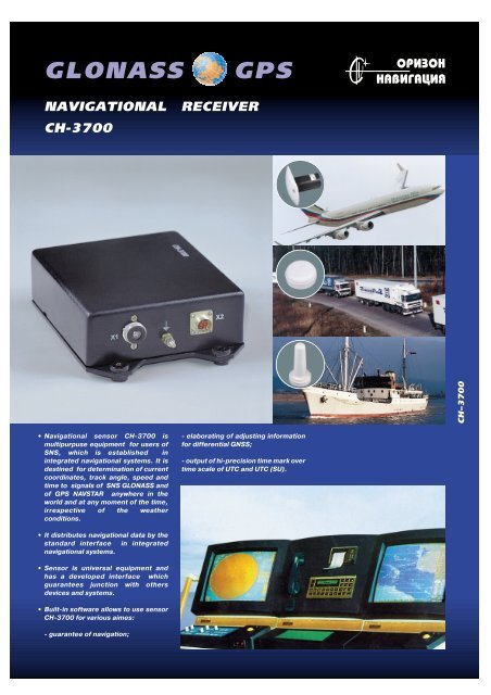
<strong>GLONASS</strong> <strong>GPS</strong><br />
NAVIGATIONAL RECEIVER<br />
CH-3700<br />
• Navigational sensor CH-3700 is<br />
multipurpuse equipment for users of<br />
SNS, which is established in<br />
integrated navigational systems. It is<br />
destined for determination of current<br />
coordinates, track angle, speed and<br />
time to signals of SNS <strong>GLONASS</strong> and<br />
of <strong>GPS</strong> NAVSTAR anywhere in the<br />
world and at any moment of the time,<br />
irrespective of the weather<br />
conditions.<br />
• It distributes navigational data by the<br />
standard interface in integrated<br />
navigational systems.<br />
• Sensor is universal equipment and<br />
has a developed interface which<br />
guarantees junction with others<br />
devices and systems.<br />
• Built-in software allows to use sensor<br />
CH-3700 for various aimes:<br />
- guarantee of navigation;<br />
- elaborating of adjusting information<br />
for differential GNSS;<br />
- output of hi-precision time mark over<br />
time scale of UTC and UTC (SU).<br />
СН–3700
СН-3700<br />
<strong>GLONASS</strong>/<strong>GPS</strong><br />
NAVIGATIONAL<br />
RECEIVER<br />
Technical characteristics<br />
• 14 parallel channels<br />
• Frequency - L1, C/A code (<strong>GPS</strong>);<br />
L1, ПТ code (<strong>GLONASS</strong>)<br />
• Accuracy (RMS):<br />
position - 10-20 m GNSS* (10 m**),<br />
10-30 m <strong>GLONASS</strong>*,<br />
25-40 m <strong>GPS</strong> (10 m**);<br />
altitude - 15-35 m GNSS* (15 m**),<br />
15-50 m <strong>GLONASS</strong>*,<br />
70 m <strong>GPS</strong> (15 m**);<br />
velocity - 0.1 m/s GNSS*,<br />
0.1 m/s <strong>GLONASS</strong>*,<br />
0.5 m/s <strong>GPS</strong> (0,1 m/s**).<br />
• Accuracy of a differential mode (RMS):<br />
position - 1-5 m;<br />
altitude - 3-7 m.<br />
• Error in measurements over pseudo<br />
range channel 0.3 m.<br />
• Error in measurements carrier phase<br />
channel 4 mm.<br />
• Error in determing of time :<br />
GNSS* - 100 ns ,<br />
<strong>GLONASS</strong>* - 100 ns,<br />
<strong>GPS</strong> - 170 ns.<br />
• Initial time - "cold" start not over 180 s,<br />
"warm" start not over 90 s.<br />
• Coordinate systems : WGS-84, PZ-90,<br />
CK-42.<br />
NAVIS Research Design Lab.<br />
Tufeleva roscha st. 12,<br />
109280, Moscow, Russia<br />
Phone/fax: (095) 274 63 04<br />
E-mail: navis@systud.msk.su<br />
http://www.navis.ru<br />
Both ports (RS232, RS422) may be<br />
configured to the next protocols:<br />
- NMEA0183 (IEC1162) - receiving and<br />
transmitting of navigational information ;<br />
- RTCM SC104 - receiving and transmitting<br />
of differential correction;<br />
• Time to resume resolving after<br />
momentary (up to 20 sec) fall of<br />
navigational satellite radio signals - up to<br />
6 sec.<br />
• Rate of output navigational information<br />
renewal once per second.<br />
Interface<br />
• Two RS232 input/output ports (or RS422<br />
+ RS232).<br />
• Protocols IEC1162 (NMEA0183), BINR,<br />
RTCM SC-104.<br />
• Exchange speed not over 38400 bites/s.<br />
Physical characteristics<br />
• Operating temperature -40…+55°C .<br />
• Storage temperature -60…+70°C.<br />
• Operating humidity 98% (25°C).<br />
• Size 140 mm x 182 mm x 57 mm<br />
• Weight not more 1.2 kg<br />
• Power supply 10-30 V.<br />
• Power consumed not more 7,5 Wt (with<br />
antenna)<br />
Specification<br />
Sensor unit CH-3700<br />
Antenna unit<br />
Fixing devices set<br />
Operation manual<br />
Service software<br />
- BINR -controlling module, transmitting<br />
of navigational data and information about<br />
satellites " health";<br />
- output for external users "rough"<br />
measurements.<br />
Software allows to control navigation<br />
sensor and store navigation data.<br />
Auxiliary equipment<br />
Interface cable<br />
Supply cable<br />
Antenna cable (up to 50 m), with<br />
additonal low-noise amplifier (LNA)<br />
Antenna fixing component sets<br />
* with fully deployed <strong>GLONASS</strong><br />
** without SA<br />
Antennas Microstripline, Spiral,4 contact, Microstripline,<br />
low profile (automob.) 2 turn, maritime low profile (aviat. ARINC 743A)<br />
Frequency range 1570-1610 MHz 1570-1615 MHz 1570-1611 MHz<br />
Polarization RH, round RH, round RH, round<br />
Gain of LNA 30 dB 30 dB 28.5 dB<br />
NF of LNA not over