2012 Eagle SKi Club Antarctic Expedition Report VERSION - UIAA
2012 Eagle SKi Club Antarctic Expedition Report VERSION - UIAA
2012 Eagle SKi Club Antarctic Expedition Report VERSION - UIAA

You also want an ePaper? Increase the reach of your titles
YUMPU automatically turns print PDFs into web optimized ePapers that Google loves.
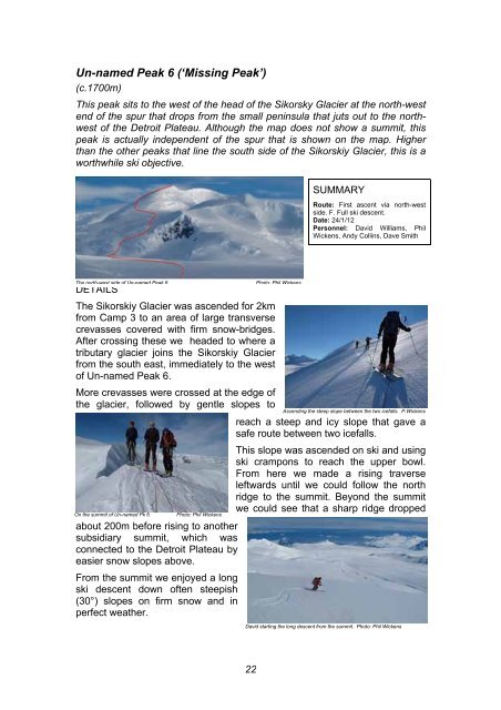
Un-named Peak 6 (‘Missing Peak’)<br />
(c.1700m)<br />
This peak sits to the west of the head of the Sikorsky Glacier at the north-west<br />
end of the spur that drops from the small peninsula that juts out to the northwest<br />
of the Detroit Plateau. Although the map does not show a summit, this<br />
peak is actually independent of the spur that is shown on the map. Higher<br />
than the other peaks that line the south side of the Sikorskiy Glacier, this is a<br />
worthwhile ski objective.<br />
The north-west side of Un-named Peak 6. Photo: Phil Wickens<br />
DETAILS<br />
The Sikorskiy Glacier was ascended for 2km<br />
from Camp 3 to an area of large transverse<br />
crevasses covered with firm snow-bridges.<br />
After crossing these we headed to where a<br />
tributary glacier joins the Sikorskiy Glacier<br />
from the south east, immediately to the west<br />
of Un-named Peak 6.<br />
More crevasses were crossed at the edge of<br />
the glacier, followed by gentle slopes to<br />
On the summit of Un-named Pk 6. Photo: Phil Wickens<br />
about 200m before rising to another<br />
subsidiary summit, which was<br />
connected to the Detroit Plateau by<br />
easier snow slopes above.<br />
From the summit we enjoyed a long<br />
ski descent down often steepish<br />
(30°) slopes on firm snow and in<br />
perfect weather.<br />
22<br />
SUMMARY<br />
Route: First ascent via north-west<br />
side. F. Full ski descent.<br />
Date: 24/1/12<br />
Personnel: David Williams, Phil<br />
Wickens, Andy Collins, Dave Smith<br />
Ascending the steep slope between the two icefalls. P.Wickens<br />
reach a steep and icy slope that gave a<br />
safe route between two icefalls.<br />
This slope was ascended on ski and using<br />
ski crampons to reach the upper bowl.<br />
From here we made a rising traverse<br />
leftwards until we could follow the north<br />
ridge to the summit. Beyond the summit<br />
we could see that a sharp ridge dropped<br />
David starting the long descent from the summit. Photo: Phil Wickens