Ancient Earthmovers Of the Amazon - University of Pennsylvania
Ancient Earthmovers Of the Amazon - University of Pennsylvania
Ancient Earthmovers Of the Amazon - University of Pennsylvania

You also want an ePaper? Increase the reach of your titles
YUMPU automatically turns print PDFs into web optimized ePapers that Google loves.
1148<br />
NEWSFOCUS<br />
<strong>Ancient</strong> <strong>Earthmovers</strong><br />
<strong>Of</strong> <strong>the</strong> <strong>Amazon</strong><br />
The forested western <strong>Amazon</strong> was once thought barren <strong>of</strong> complex<br />
human culture. But researchers are now uncovering enigmatic earthworks<br />
left by large, organized societies that once lived and farmed here<br />
Alceu Ranzi was a geography student in<br />
1977 when he helped discover half a dozen<br />
huge, prehistoric rings carved into <strong>the</strong> landscape<br />
in his home state <strong>of</strong> Acre in western<br />
Brazil. At <strong>the</strong> time,<br />
Online<br />
sciencemag.org<br />
Hear author<br />
Charles C. Mann<br />
discuss <strong>the</strong> earthworks<br />
left by <strong>the</strong> early<br />
<strong>Amazon</strong>ians.<br />
he was helping to<br />
conduct <strong>the</strong> firstever<br />
full archaeological<br />
survey <strong>of</strong> <strong>Amazon</strong>ia,<br />
which was<br />
being opened up for<br />
cattle ranches at a<br />
speed that was caus-<br />
ing worldwide protests. The earthworks<br />
came to light on newly logged land.<br />
The find attracted little attention. The<br />
Smithsonian-sponsored National Program <strong>of</strong><br />
Archaeological Research in <strong>the</strong> <strong>Amazon</strong><br />
Basin did not formally announce <strong>the</strong> rings<br />
for 11 years, and even <strong>the</strong>n only in a littleread<br />
report. And Ranzi, who went on to<br />
become a respected paleontologist, most<br />
recently at <strong>the</strong> Federal <strong>University</strong> <strong>of</strong> Acre in<br />
Rio Branco, didn’t get back to studying <strong>the</strong><br />
ditches until more than a decade after that.<br />
On a flight to Rio Branco in 1999, he spotted<br />
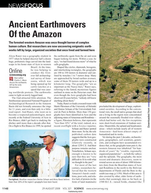
Farsighted. Brazilian researchers Denise Schaan and Alceu Ranzi believe<br />
fewer than 10% <strong>of</strong> <strong>the</strong> region’s geoglyphs have been found.<br />
<strong>the</strong> earthworks again from <strong>the</strong> air and soon<br />
began looking for more. Within a year, he<br />
says, “we had found dozens more” <strong>of</strong> what he<br />
calls geoglyphs.<br />
Shaped like circles, diamonds, hexagons,<br />
and interlocking rectangles, <strong>the</strong> geoglyphs<br />
are 100 to 350 meters in diameter and outlined<br />
by trenches 1 to 7 meters deep. Many<br />
are approached by broad ear<strong>the</strong>n avenues,<br />
some <strong>of</strong> <strong>the</strong>m 50 meters wide and up to a<br />
kilometer long. The geoglyphs “are as<br />
important as <strong>the</strong> Nazca lines,” Ranzi says,<br />
referring to <strong>the</strong> famed, mysterious figures<br />
outlined in stone on <strong>the</strong> Peruvian coast. But<br />
even though <strong>the</strong> Acre geoglyphs had been<br />
observed 20 years before, “nobody still knew<br />
anything about <strong>the</strong>m.”<br />
Today, Ranzi co-leads a research team with<br />
Martti Pärssinen <strong>of</strong> <strong>the</strong> <strong>University</strong> <strong>of</strong> Helsinki<br />
and Denise Schaan <strong>of</strong> <strong>the</strong> Universidade Federal<br />
do Pará in Belém. More than 150 geoglyphs<br />
have been identified in Acre and <strong>the</strong><br />
adjoining states <strong>of</strong> <strong>Amazon</strong>as and Rondônia—<br />
a figure, Pärssinen believes, that represents<br />
“less than 10%” <strong>of</strong> <strong>the</strong> total; indeed, on a<br />
recent overflight with a Science reporter,<br />
Schaan and Ranzi spotted<br />
three more. So far, <strong>the</strong> sole<br />
published carbon date<br />
suggests that <strong>the</strong> Acre geoglyphs<br />
were constructed<br />
relatively recently, in<br />
about 1250 C.E. And <strong>the</strong>ir<br />
purpose remains unclear.<br />
None<strong>the</strong>less, Schaan says,<br />
enough is known to be<br />
sure that <strong>the</strong>y are “very<br />
difficult to fit in with what<br />
we thought in <strong>the</strong> past.”<br />
For most <strong>of</strong> <strong>the</strong> last<br />
century, researchers believed<br />
that <strong>the</strong> western<br />
<strong>Amazon</strong>’s harsh condi-<br />
tions, poor soils, and relative<br />
lack <strong>of</strong> protein (in <strong>the</strong><br />
form <strong>of</strong> land mammals)<br />
29 AUGUST 2008 VOL 321 SCIENCE www.sciencemag.org<br />
Published by AAAS<br />
precluded <strong>the</strong> development <strong>of</strong> large, sophisticated<br />
societies. According to <strong>the</strong> conventional<br />
view, <strong>the</strong> small native groups that eked<br />
out a living in <strong>the</strong> region were concentrated<br />
around <strong>the</strong> seasonally flooded river valleys,<br />
which had better soil; <strong>the</strong> few exceptions<br />
were short-lived extensions <strong>of</strong> Andean societies.<br />
Meanwhile, <strong>the</strong> upland and headwaters<br />
areas—which include nearly all <strong>of</strong> western<br />
<strong>Amazon</strong>ia—had been almost empty <strong>of</strong><br />
humankind and its works.<br />
Yet during <strong>the</strong> past 2 decades, archaeologists,<br />
geographers, soil scientists, geneticists,<br />
and ecologists have accumulated evidence<br />
that, as <strong>the</strong> geoglyphs team puts it, <strong>the</strong><br />
western <strong>Amazon</strong> was inhabited “for hundreds<br />
<strong>of</strong> years” by “sizable, regionally<br />
organized populations”—in both <strong>the</strong> valleys<br />
and <strong>the</strong> uplands. The geoglyphs, <strong>the</strong> most<br />
recent and dramatic discovery, seem to<br />
extend across an area <strong>of</strong> about 1000 kilometers<br />
(km) from <strong>the</strong> Brazilian states <strong>of</strong> Acre<br />
and Rondônia in <strong>the</strong> north to <strong>the</strong> Bolivian<br />
departments <strong>of</strong> Pando and <strong>the</strong> Beni in <strong>the</strong><br />
south (see map, p.1150). Much <strong>of</strong> this area is<br />
also covered by o<strong>the</strong>r, older forms <strong>of</strong> earthworks<br />
that seemingly date as far back as<br />
2500 B.C.E.: raised fields, channel-like<br />
CREDIT: C. C. MANN<br />
on September 4, 2008<br />
www.sciencemag.org<br />
Downloaded from
CREDIT: C. C. MANN<br />
canals, tall settlement mounds, fish weirs,<br />
circular pools, and long, raised causeways<br />
(Science, 4 February 2000, p. 786), suggesting<br />
<strong>the</strong> presence <strong>of</strong> several cultures over a<br />
long period. And on page 1214 <strong>of</strong> this issue<br />
<strong>of</strong> Science, a U.S.-Brazilian team proposes<br />
that indigenous people in <strong>the</strong> south-central<br />
<strong>Amazon</strong>, 1400 km from Acre, lived in dense<br />
settlements in a form <strong>of</strong> early urbanism and<br />
created ditches and ear<strong>the</strong>n walls that some<br />
say resemble <strong>the</strong> geoglyphs (see sidebar).<br />
Researchers are still puzzling over<br />
whe<strong>the</strong>r and how <strong>the</strong>se earthworks fit<br />
toge<strong>the</strong>r and what <strong>the</strong>y reveal about <strong>the</strong> people<br />
who created <strong>the</strong>m. But already <strong>the</strong> implications<br />
<strong>of</strong> <strong>the</strong>se enormous endeavors are<br />
clear, says Clark Erickson, a <strong>University</strong> <strong>of</strong><br />
<strong>Pennsylvania</strong> researcher who has been working<br />
in <strong>the</strong> area with Bolivian colleagues since<br />
1995. Far from being trapped by <strong>the</strong> <strong>Amazon</strong>’s<br />
ecological obstacles, he says, <strong>the</strong>se<br />
large populations systematically transformed<br />
<strong>the</strong> landscapes around <strong>the</strong>m. One example:<br />
Because geoglyphs cannot readily be constructed<br />
or even seen in wooded areas, <strong>the</strong><br />
researchers argue that people must have made<br />
<strong>the</strong>m at a time when <strong>the</strong> region had little tree<br />
cover—meaning that in <strong>the</strong> not-too-distant<br />
past <strong>the</strong> great forests <strong>of</strong> <strong>the</strong> western <strong>Amazon</strong><br />
may have been considerably smaller.<br />
Not only did <strong>the</strong> peoples <strong>of</strong> western <strong>Amazon</strong><br />
alter <strong>the</strong>ir environments, but <strong>the</strong>y also<br />
transformed <strong>the</strong> biota in <strong>the</strong>m. Emerging<br />
evidence suggests that this little-known<br />
region may have been a place where longago<br />
farmers first bred some <strong>of</strong> <strong>the</strong> world’s<br />
most important crops. In Erickson’s view,<br />
western <strong>Amazon</strong>ia serves as a model <strong>of</strong> how<br />
human beings create and maintain productive<br />
landscapes from even <strong>the</strong> most apparently<br />
limited environments.<br />
The new findings show that <strong>the</strong> region<br />
was “a cosmopolitan crossroads” between<br />
<strong>the</strong> societies <strong>of</strong> <strong>the</strong> eastern <strong>Amazon</strong> and <strong>the</strong><br />
Andes, <strong>of</strong> whom <strong>the</strong> most famous were <strong>the</strong><br />
Inka, says Susanna Hecht, a geographer at<br />
<strong>the</strong> <strong>University</strong> <strong>of</strong> California, Los Angeles:<br />
“You have every language group in lowland<br />
South America represented <strong>the</strong>re.” She adds,<br />
“It was a major cultural center—and it’s<br />
incredible that this is just coming out.”<br />
Counterfeit paradise, or a real one?<br />
Archaeologists once regarded <strong>Amazon</strong>ia as<br />
unpromising terrain. Clearing <strong>the</strong> forests for<br />
agriculture risks destroying fragile tropical<br />
NEWSFOCUS<br />
Squared <strong>of</strong>f. The Fazenda<br />
Atlântica geoglyph in Acre<br />
is 250 meters on a side.<br />
soils by exposing <strong>the</strong>m to <strong>the</strong> tropics’punishing<br />
heat and rain, a contention that lay at <strong>the</strong><br />
heart <strong>of</strong> Smithsonian archaeologist Betty<br />
Meggers’s <strong>Amazon</strong>ia: Man and Culture in a<br />
Counterfeit Paradise (2nd ed., 1996), probably<br />
<strong>the</strong> most influential book written about<br />
<strong>the</strong> area. Meggers reasoned that in consequence,<br />
settlements could not long survive<br />
with conventional farming; she once suggested<br />
that <strong>the</strong> river basin’s ecological constraints<br />
limited maximum village size to<br />
about 1000 people. In addition, those people<br />
would have left little behind, because <strong>Amazon</strong>ia<br />
has little stone or metal. As a result,<br />
“99% <strong>of</strong> material culture was perishable,”<br />
Erickson says. “Cane, chonta [palm wood],<br />
bones, baskets, wood—none <strong>of</strong> it survives<br />
<strong>the</strong>se conditions.” Except for pottery, “<strong>the</strong><br />
whole culture, even if it was <strong>the</strong>re for thousands<br />
<strong>of</strong> years, seems to be gone.”<br />
“In <strong>the</strong> Andes, <strong>the</strong> societies are easy to<br />
see,” says Sergio Calla, a student at <strong>the</strong> Universidad<br />
Mayor de San Andrés in La Paz who<br />
works with Erickson. “There is no forest covering<br />
up <strong>the</strong>ir traces. Also, <strong>the</strong>y could build<br />
in stone, which is rare here. But this region is<br />
just as rich culturally. We just have to look<br />
harder and smarter.”<br />
www.sciencemag.org SCIENCE VOL 321 29 AUGUST 2008 1149<br />
Published by AAAS<br />
on September 4, 2008<br />
www.sciencemag.org<br />
Downloaded from
NEWSFOCUS<br />
1150<br />
Looking smarter, in Erickson’s view,<br />
means going beyond archaeology’s traditional<br />
focus on <strong>the</strong> individual site to entire<br />
landscapes. “What <strong>Amazon</strong>ian peoples did<br />
in constructing/building environments was<br />
more visible and permanent at a regional<br />
scale than at <strong>the</strong> site scale,” he argues. To<br />
study at this scale, archaeologists are adopt-<br />
PERU<br />
Lake<br />
Titicaca<br />
ing new methods, from soil chemistry to network<br />
<strong>the</strong>ory.<br />
The Beni in Bolivia, where Erickson’s<br />
team focuses its efforts, is an example.<br />
Exceptionally low and flat, much <strong>of</strong> <strong>the</strong><br />
department is covered for up to 4 months <strong>of</strong><br />
<strong>the</strong> year by a slowly moving wash <strong>of</strong> water—<br />
snowmelt from <strong>the</strong> Andes and heavy local<br />
rainfall—that is typically 30 to 100 centimeters<br />
deep. During <strong>the</strong> dry season, <strong>the</strong> water<br />
evaporates and <strong>the</strong> Beni becomes a hot, arid<br />
savanna, kept open by annual burning. In <strong>the</strong><br />
low areas, early inhabitants avoided <strong>the</strong> flood<br />
by using natural knolls known as islas and by<br />
constructing thousands <strong>of</strong> lomas (mounds<br />
typically 1 to 5 hectares) as dwelling places.<br />
Most lomas were small—artificial hummocks<br />
barely above <strong>the</strong> water—but a small<br />
percentage were up to 18 meters in height.<br />
Some are still inhabited by native groups.<br />
Living on this artificial inland archipelago,<br />
<strong>Amazon</strong>ian peoples ate a diet heavy in<br />
fish, which migrate and spawn in <strong>the</strong> flooded<br />
savannas. Today, as Erickson discovered in<br />
2000, networks <strong>of</strong> ear<strong>the</strong>n fish weirs still<br />
crisscross a 500-square-kilometer area in <strong>the</strong><br />
grassland. These low, interconnected berms<br />
change direction, zigzag-style, every 10 to<br />
30 meters. At <strong>the</strong> angles are funnel-like<br />
openings for nets or traps. Built as early as<br />
<strong>the</strong> 13th century, <strong>the</strong>y fell into disuse only in<br />
<strong>the</strong> 18th century. “Think <strong>of</strong> it as aquaculture,”<br />
Erickson says. “The weirs allowed<br />
people to manage and harvest <strong>the</strong> catch.”<br />
CULTIVATED LANDSCAPES OF THE SOUTHWEST AMAZON<br />
ACRE<br />
PANDO RONDÔNIA<br />
THE BENI<br />
Madeira River<br />
BOLIVIA<br />
BRAZIL<br />
Tapajós River<br />
Pacific<br />
Ocean<br />
Atlantic<br />
Ocean<br />
Potential geoglyph area<br />
Known geoglyphs<br />
Canals, causeways<br />
Raised fields<br />
Large mounds<br />
“Garden cities”<br />
Modern political boundaries<br />
Xingu River<br />
50 100 150 km<br />
0 50 100 150 mi<br />
<strong>Ancient</strong> crossroads? Researchers suspect that prehistoric earthworks across <strong>the</strong> western <strong>Amazon</strong> may be related.<br />
When <strong>the</strong> waters receded, <strong>the</strong> area’s early<br />
inhabitants ensured that <strong>the</strong>y drained into<br />
hundreds <strong>of</strong> artificial fish ponds. Typically<br />
about 30 meters across, <strong>the</strong>y are <strong>of</strong>ten full <strong>of</strong><br />
fish today.<br />
Agriculture was just as intensive. In a<br />
broad, 50,000-square-kilometer swath <strong>of</strong><br />
savanna around <strong>the</strong> mounds, <strong>the</strong> Beni’s<br />
indigenous peoples built raised fields—<br />
artificial platforms <strong>of</strong> soil that lift crops above<br />
<strong>the</strong> floodwaters, according to research by<br />
geographer William Denevan, a pr<strong>of</strong>essor<br />
emeritus at <strong>the</strong> <strong>University</strong> <strong>of</strong> Wisconsin,<br />
Madison, who in 1963 was one <strong>of</strong> <strong>the</strong> first to<br />
call attention to <strong>the</strong>m. Like raised beds in temperate-zone<br />
gardens, <strong>the</strong> mounds promote<br />
drainage and increase <strong>the</strong> amount <strong>of</strong> topsoil.<br />
From <strong>the</strong> few carbon dates available, Erickson<br />
says, “we see raised fields coming in and out<br />
<strong>of</strong> production from 3000 B.P. to 500 B.P.”—or<br />
until roughly <strong>the</strong> time <strong>the</strong> conquistadors<br />
arrived, bringing diseases that wiped out<br />
much <strong>of</strong> <strong>the</strong> native population. “Like any agricultural<br />
fields, <strong>the</strong>se were not used forever.<br />
They go in and out <strong>of</strong> production, which suggests<br />
to me a long-term but dynamic system.”<br />
29 AUGUST 2008 VOL 321 SCIENCE www.sciencemag.org<br />
Published by AAAS<br />
Because <strong>the</strong> mounds, weirs, and fields<br />
required enormous labor to construct and<br />
maintain, Erickson believes <strong>the</strong>se societies<br />
must have had large populations—“tens or<br />
even hundreds <strong>of</strong> thousands <strong>of</strong> people.” Some<br />
early Jesuit accounts back this view.<br />
To move people and goods around, Indians<br />
built networks <strong>of</strong> ruler-straight causeways and<br />
canals, some <strong>of</strong> <strong>the</strong>m as long as 7 km.<br />
Puzzlingly, <strong>the</strong> causeways and canals are common<br />
near raised fields but not around settlement<br />
mounds. To make sense <strong>of</strong> <strong>the</strong> pattern,<br />
Erickson and Patrick Brett—a Wall Streeter<br />
taking time <strong>of</strong>f to pursue his academic<br />
dreams—are trying to apply <strong>the</strong> techniques <strong>of</strong><br />
network analysis to search for key nodes in <strong>the</strong><br />
networks <strong>of</strong> connected causeways, canals,<br />
mounds, and fields. The hope, he says, is “to<br />
stop us from flailing around, trying to figure<br />
out which <strong>of</strong> <strong>the</strong> thousands <strong>of</strong> islas we should<br />
put a trench into.” Early analysis, Erickson<br />
says, “shows a few key forest islands in control<br />
<strong>of</strong> a vast network <strong>of</strong> communication and<br />
interaction covering 550 square kilometers: as<br />
large as many early states.”<br />
Birthplace <strong>of</strong> crops<br />
Even as archaeologists try to work out how <strong>the</strong><br />
area’s early inhabitants reshaped <strong>the</strong>ir physical<br />
environment, botanists are beginning to trace<br />
out <strong>the</strong>ir impacts in its genetic heritage. “The<br />
<strong>Amazon</strong> is world-famous as a center for biodiversity,”<br />
says botanist Charles R. Clement <strong>of</strong><br />
Brazil’s National Institute for <strong>Amazon</strong>ian<br />
Research in Manaus. “But its role in agricultural<br />
biodiversity remains still too little<br />
known.” In his view, <strong>the</strong> western <strong>Amazon</strong> was<br />
a center for plant domestication—a “Vavilov<br />
center,” as botanists call <strong>the</strong>m, after pioneering<br />
Soviet botanist Nikolai Vavilov, who<br />
invented <strong>the</strong> concept.<br />
Agricultural geneticists have long<br />
accepted that <strong>the</strong> western <strong>Amazon</strong> was <strong>the</strong><br />
development ground for peanuts, Brazilian<br />
broad beans (Canavalia plagiosperma), and<br />
two species <strong>of</strong> chili pepper (Capsicum baccatum<br />
and C. pubescens; see Science, 29 June<br />
2007, p. 1830). But <strong>the</strong> list is much longer,<br />
Hecht says. For example, she would add rubber,<br />
made from <strong>the</strong> sap <strong>of</strong> Hevea brasiliensis.<br />
Used for countless purposes by pre-<br />
Columbian populations, “it is at least a semidomesticate,<br />
and it was clearly distributed by<br />
humans.” Also on her list are tobacco, cacao,<br />
<strong>the</strong> tuber Xanthosoma sagittifolium, peach<br />
palm (Bactris gasipaes, a major <strong>Amazon</strong>ian<br />
crop), and, most important, <strong>the</strong> worldwide<br />
staple Manihot esculenta, better known as<br />
manioc, cassava, or yuca.<br />
Because <strong>the</strong> domestications <strong>of</strong> manioc<br />
and peach palm apparently occurred before<br />
SOURCE: C. C. MANN<br />
on September 4, 2008<br />
www.sciencemag.org<br />
Downloaded from
CREDIT: M. J. HECKENBERGER ET AL.<br />
<strong>the</strong> earthworks were built, agriculture may<br />
have, as in o<strong>the</strong>r cultures, created <strong>the</strong> surplus<br />
necessary for complex societies to emerge.<br />
But a “note <strong>of</strong> caution” is appropriate in such<br />
speculations, says anthropologist Peter Stahl<br />
<strong>of</strong> Binghamton <strong>University</strong> in New York.<br />
Although “tending to agree” that <strong>the</strong> region<br />
was a center for domestication, he notes that<br />
it’s possible that ancestral species still survive<br />
in southwestern <strong>Amazon</strong>ia “because it’s<br />
The Western <strong>Amazon</strong>’s “Garden Cities”<br />
IN 1902, BRITISH PLANNER EBENEZER HOWARD PUBLISHED GARDEN<br />
Cities <strong>of</strong> To-Morrow, which argued that <strong>the</strong> coming century’s cities—metropolises<br />
ringed by bedroom communities—should be replaced by more livable,<br />
medium-sized “garden cities,” linked by railroads and girdled by agricultural<br />
green belts. Howard inspired planners in <strong>the</strong> United Kingdom and Germany,<br />
but by <strong>the</strong> 1970s his views had been forgotten. Now, on page 1214, a U.S.-<br />
Brazilian research team led by archaeologist Michael Heckenberger <strong>of</strong> <strong>the</strong><br />
<strong>University</strong> <strong>of</strong> Florida, Gainesville, reports finding a set <strong>of</strong> urban settlements<br />
startlingly similar to Howard’s garden cities—built in <strong>the</strong> forests <strong>of</strong> <strong>the</strong> southcentral<br />
<strong>Amazon</strong> as early as 1250 C.E.<br />
The paper identifies dozens <strong>of</strong> densely packed “towns, villages, and<br />
hamlets” covering perhaps 30,000 square kilometers—an area <strong>the</strong> size <strong>of</strong><br />
Belgium—in <strong>the</strong> headwaters <strong>of</strong> <strong>the</strong> Xingu River. The settlements, built by<br />
indigenous peoples, were tied toge<strong>the</strong>r by “well-planned road networks”<br />
and embedded in a matrix <strong>of</strong> agricultural land. (By coincidence, <strong>the</strong> Xingu<br />
complexes are also where famed British adventurer Percy Fawcett disappeared<br />
in 1925 while searching for a mythical lost city known as “Z.”)<br />
The new claims are sure to stir controversy. “Some urbanists may say,<br />
‘In your dreams,’ ” Heckenberger says, laughing. But he argues that <strong>the</strong><br />
key comparison is not to big centralized cities such as Uruk or A<strong>the</strong>ns, “but<br />
<strong>the</strong> o<strong>the</strong>r thousand poleis [in ancient Greece] that were not A<strong>the</strong>ns.” Like<br />
<strong>the</strong>m, he says, <strong>the</strong> Xingu polities “have sophisticated systems <strong>of</strong> regional<br />
planning, a strongly hierarchical spatial organization, and a basic corehinterland<br />
division within clearly marked territories.”<br />
The new work “raises huge and impor-<br />
tant questions,” says Susanna Hecht, an<br />
<strong>Amazon</strong> specialist at <strong>the</strong> <strong>University</strong> <strong>of</strong> California,<br />
Los Angeles. It fur<strong>the</strong>r contradicts <strong>the</strong><br />
once-dominant view that <strong>the</strong> <strong>Amazon</strong>ian<br />
uplands and headwaters regions were nearly<br />
empty. Indeed, <strong>the</strong> earthworks are similar<br />
enough to <strong>the</strong> geoglyphs to <strong>the</strong> west in <strong>the</strong><br />
Beni (see main text), says geographer<br />
William Denevan <strong>of</strong> <strong>the</strong> <strong>University</strong> <strong>of</strong> Wisconsin,<br />
Madison, that “<strong>the</strong>y must be related,<br />
though we don’t know how.” Hecht also<br />
notes that <strong>the</strong> Xingu settlements challenge<br />
<strong>the</strong> implicit belief that “current urbanism<br />
with its hyperconcentration is a kind <strong>of</strong> historical<br />
norm,” when “smaller agglomerations<br />
interacting with forest and agriculture”<br />
may have been widespread, too.<br />
Since <strong>the</strong> early 1990s, Heckenberger<br />
has focused on <strong>the</strong> upper Xingu River, much<br />
<strong>of</strong> which is a 2.6-million-hectare reserve set<br />
aside for 14 indigenous groups, including<br />
out <strong>of</strong> <strong>the</strong> way” ra<strong>the</strong>r than because domestication<br />
happened <strong>the</strong>re.<br />
Strikingly, one <strong>of</strong> <strong>the</strong> <strong>Amazon</strong>’s most<br />
important agricultural innovations may have<br />
originated soon after <strong>the</strong> breeding <strong>of</strong> modern<br />
manioc and peach palm. Known as terra preta,<br />
it consists <strong>of</strong> patches <strong>of</strong> soil ranging from less<br />
than 1 hectare to several hectares that have been<br />
modified by adding huge quantities <strong>of</strong> crumbled<br />
charcoal (Science, 9 August 2002, p. 920).<br />
Digging in. Local Kuikuro<br />
collaborators help excavate<br />
an ancient earthwork.<br />
NEWSFOCUS<br />
An informal Brazil-Germany-U.S. collaboration<br />
has been investigating this artificial soil,<br />
which maintains its fertility for long periods<br />
despite <strong>the</strong> harsh tropical conditions. Earlier<br />
this year, five researchers led by Christoph<br />
Steiner <strong>of</strong> <strong>the</strong> <strong>University</strong> <strong>of</strong> Bayreuth in Germany<br />
reported that adding charcoal and soot to<br />
wea<strong>the</strong>red <strong>Amazon</strong>ian soils caused a “sharp<br />
increase” in microbial activity: Soils damaged<br />
by exposure became, so to speak, more alive.<br />
<strong>the</strong> Kuikuro, who number about 500. Two weeks after Heckenberger arrived,<br />
community leader (and co-author <strong>of</strong> <strong>the</strong> Science paper) Afukaka Kuikuro<br />
showed him <strong>the</strong> ruins <strong>of</strong> an ear<strong>the</strong>n wall more than a kilometer long.<br />
Heckenberger realized that <strong>the</strong> wall, which was associated with a moatlike<br />
ditch 10 or more meters wide, was from before <strong>the</strong> time <strong>of</strong> Columbus. Then,<br />
he says, “I found out <strong>the</strong> Kuikuro knew about a lot <strong>of</strong> <strong>the</strong>se walled settlements,<br />
and <strong>the</strong>y weren’t small.”<br />
Patiently converting indigenous knowledge into GPS-verified mapping<br />
and archaeological excavation, Heckenberger’s team discovered that <strong>the</strong><br />
present-day Kuikuro forest concealed what had been two regional polities,<br />
each about 250 square kilometers, comprised <strong>of</strong> small villages and towns centered<br />
on plazas 120 to 150 meters across. Each polity had a kind <strong>of</strong> capital<br />
with roads radiating out to o<strong>the</strong>r villages and towns. “The settlements are<br />
packed in <strong>the</strong> region along <strong>the</strong> Xingu,” Heckenberger says, “one after<br />
ano<strong>the</strong>r, always in this highly regular pattern.” Each center has equidistant<br />
towns to its north and south, for example, as well as smaller towns east and<br />
west, with <strong>the</strong> two axes being <strong>of</strong> constant lengths. Similarly, <strong>the</strong> prehistoric<br />
plazas in <strong>the</strong> towns are regularly patterned, with <strong>the</strong> primary and secondary<br />
leaders’ houses facing each o<strong>the</strong>r at opposite ends. “All <strong>the</strong>ir roads are amazingly<br />
straight, too,” Heckenberger says. “If <strong>the</strong>re was a wetland, <strong>the</strong>y just built<br />
causeways and bridges over it.” In his view, this careful layout suggests that<br />
<strong>the</strong> capitals had a ritualistic function.<br />
To Heckenberger, <strong>the</strong> settlements represent a novel kind <strong>of</strong> urbanism. As<br />
he readily agrees, “No single Xingu settlement merits <strong>the</strong> term ‘city.’ But what<br />
do you do with a core <strong>of</strong> five settlements a few kilometers away from each<br />
o<strong>the</strong>r? A fast walk from one to ano<strong>the</strong>r would take you 15 minutes, maximum.”<br />
Radiocarbon dating suggests that <strong>the</strong>se<br />
communities were at <strong>the</strong>ir height from <strong>the</strong><br />
13th to <strong>the</strong> 16th centuries, with a regional<br />
population greater than 50,000, based on<br />
extrapolation from current settlements. Soon<br />
after Europeans reached Brazil in 1500, diseases<br />
killed two-thirds or more <strong>of</strong> <strong>the</strong> native<br />
population, and forest quickly grew into<br />
cleared areas; colonists later tended to<br />
believe that <strong>the</strong> forest was <strong>of</strong> great antiquity.<br />
These pre-Columbian urban concentrations<br />
may have lessons for today’s planners.<br />
“Given <strong>the</strong> complexity <strong>of</strong> <strong>Amazon</strong>ian<br />
biotic and water regimes, a decentralized<br />
model may have been more adapted to<br />
address very large volumes <strong>of</strong> water that<br />
hang around for a long time,” Hecht says.<br />
Because tropical areas today are dominated<br />
by huge centralized cities, she says,<br />
it is striking to note that <strong>the</strong>ir original<br />
inhabitants chose a different path.<br />
–C.C.M.<br />
www.sciencemag.org SCIENCE VOL 321 29 AUGUST 2008 1151<br />
Published by AAAS<br />
on September 4, 2008<br />
www.sciencemag.org<br />
Downloaded from
NEWSFOCUS<br />
1152<br />
Terra preta is believed to have been an<br />
essential part <strong>of</strong> a distinctive agricultural system.<br />
According to <strong>the</strong> terra preta team, Indians<br />
slowly cleared <strong>of</strong>f <strong>the</strong> forest to create farm<br />
plots and planted annual crops such as manioc<br />
and peanut. In <strong>the</strong> past, researchers argued<br />
that as <strong>the</strong> exposed soil lost its fertility, farmers<br />
shifted to o<strong>the</strong>r areas in a pattern called<br />
“slash and burn.” But researchers now suggest<br />
that Indians instead took steps to retain soil<br />
fertility by creating terra preta. According to<br />
studies by Wisconsin’s Denevan, removing<br />
trees with stone axes was so difficult that <strong>the</strong><br />
logical path for native peoples would not have<br />
been to clear additional forest every few years<br />
but to replant <strong>the</strong> enriched fallow earth with<br />
tree species useful to humankind—rotating<br />
annual and tree crops over time.<br />
The oldest terra preta patches yet known,<br />
carbon-dated to about 2500 B.C.E., are in<br />
Walking on water. Early<br />
<strong>Amazon</strong>ians built causeways<br />
to adjust to annual floods.<br />
Rondônia, not far from <strong>the</strong> Brazil-Bolivia<br />
border, suggesting to Eduardo Goes Neves <strong>of</strong><br />
<strong>the</strong> <strong>University</strong> <strong>of</strong> São Paolo that <strong>the</strong>se techniques<br />
may have been invented <strong>the</strong>re. In surveys<br />
this year and last, Neves discovered<br />
“terra preta almost everywhere we looked.”<br />
Pärssinen, though, says that <strong>the</strong> geoglyphs<br />
team has not yet found big patches <strong>of</strong> terra<br />
preta in Acre. “How <strong>the</strong>se large groups supported<br />
<strong>the</strong>mselves <strong>the</strong>re without it is a mystery,”<br />
he says.<br />
If <strong>the</strong> rest <strong>of</strong> <strong>the</strong> Rondônia terra preta is as<br />
old as <strong>the</strong> dated patches, Neves says, “we’re<br />
looking at a huge jigsaw puzzle” <strong>of</strong> an ancient<br />
culture—or cultures. As he sees it, “in <strong>the</strong><br />
west and southwest, <strong>the</strong>re’s <strong>the</strong> mounds and<br />
canals, <strong>the</strong>re’s <strong>the</strong> development <strong>of</strong> manioc<br />
and peach palm, <strong>the</strong>re’s <strong>the</strong> fish weirs that<br />
Clark [Erickson] found—and we don’t know<br />
how any <strong>of</strong> it fits toge<strong>the</strong>r. On top <strong>of</strong> that,<br />
<strong>the</strong>re’s <strong>the</strong> geoglyphs all over <strong>the</strong> place.”<br />
Digging deep<br />
Around and atop many <strong>of</strong> <strong>the</strong> Beni forest<br />
islands are deep ditches, commonly oval or<br />
ring-shaped. Analogs <strong>of</strong> <strong>the</strong> geoglyphs<br />
found by Ranzi in Acre, <strong>the</strong>y are typically<br />
100 to 200 meters across, though some are<br />
as much as 1 km in diameter. Many are surprisingly<br />
deep; Erickson and his Bolivian<br />
co-investigator, Patricia Alvarez <strong>of</strong> <strong>the</strong><br />
Universidad Mayor de San Simón in<br />
Cochabamba, discovered one ring originally<br />
dug to 10 meters. The region is now overgrown,<br />
so <strong>the</strong> team measures geoglyphs by<br />
slowly chopping through trees and vines; during<br />
Science’s visit, Erickson spent most <strong>of</strong> an<br />
afternoon hacking with a machete through<br />
thick forest to identify <strong>the</strong> track <strong>of</strong> a single big<br />
ditch on a Global Positioning System.<br />
Partly because <strong>of</strong> <strong>the</strong> recent tree cover,<br />
nobody knows how many <strong>of</strong> <strong>the</strong>se geoglyphs<br />
exist. Erickson, for his part, says he “wouldn’t<br />
be surprised if almost every one <strong>of</strong> <strong>the</strong> artificial<br />
lomas had <strong>the</strong>m.” Perhaps backing this<br />
view, anthropologist John Walker <strong>of</strong> <strong>the</strong> <strong>University</strong><br />
<strong>of</strong> Central Florida in Orlando reports,<br />
in a forthcoming paper, <strong>the</strong> discovery <strong>of</strong><br />
ditches on savannas and river-edge forests in<br />
north-central Bolivia, in an area where <strong>the</strong>y<br />
had not previously been reported. “We found<br />
ceramics on four forest islands that we examined,”<br />
he told Science in an e-mail from<br />
Bolivia, “and each <strong>of</strong> <strong>the</strong>m also had earthworks<br />
that I am willing to call ring ditches”—<br />
circular geoglyphs.<br />
The relation <strong>of</strong> <strong>the</strong> geoglyphs to <strong>the</strong> o<strong>the</strong>r,<br />
<strong>of</strong>ten older, earthworks is unclear. “We have<br />
one set <strong>of</strong> people constructing <strong>the</strong> zanjas<br />
[ring ditches] and ano<strong>the</strong>r set <strong>of</strong> people constructing<br />
<strong>the</strong> causeways and canals,” Alvarez<br />
says. “The question is whe<strong>the</strong>r <strong>the</strong>y are <strong>the</strong><br />
same people.” In her view, <strong>the</strong> variegated<br />
29 AUGUST 2008 VOL 321 SCIENCE www.sciencemag.org<br />
Published by AAAS<br />
cultural landscape <strong>of</strong> <strong>the</strong> region probably<br />
reflects “a patchwork <strong>of</strong> different ethnic<br />
groups working in different areas” with constant,<br />
intense “interethnic communication”—a<br />
crowded, jumbled social landscape<br />
that Alvarez believes extended for hundreds<br />
<strong>of</strong> kilometers in every direction. The sphere<br />
<strong>of</strong> intense interaction, she believes, may<br />
have lasted for centuries.<br />
Researchers think it likely that <strong>the</strong> geoglyphs<br />
extend continuously between Acre<br />
and <strong>the</strong> Beni; Pärssinen notes <strong>the</strong> recent discovery<br />
<strong>of</strong> large geoglyphs near <strong>the</strong> city <strong>of</strong><br />
Riberalta, on <strong>the</strong> nor<strong>the</strong>rnmost tip <strong>of</strong> <strong>the</strong><br />
Beni. But <strong>the</strong>y cannot be sure, because<br />
between Riberalta and Rio Branco, in Acre, is<br />
about 150 km <strong>of</strong> <strong>the</strong> mostly forested department<br />
<strong>of</strong> Pando. “It seems unlikely <strong>the</strong>re is no<br />
connection, but any connection is not yet<br />
proven,” Schaan says.<br />
Nor is it known whe<strong>the</strong>r <strong>the</strong> geoglyphs<br />
served any practical function. Most <strong>of</strong> <strong>the</strong> Acre<br />
geoglyphs are on higher ground, making <strong>the</strong>m<br />
<strong>of</strong> little use for drainage. Many have outer<br />
walls that look down on <strong>the</strong> central area, suggesting<br />
that <strong>the</strong>y were not used for defense. To<br />
be sure, one <strong>of</strong> Walker’s earthworks was connected<br />
to a river “by a deep channel and had a<br />
connection to a swamp on <strong>the</strong> o<strong>the</strong>r side,” he<br />
says. “It could have been used to control water<br />
flow <strong>of</strong>f <strong>of</strong> <strong>the</strong> savanna in <strong>the</strong> dry season. So at<br />
least some <strong>of</strong> <strong>the</strong>se earthworks could have had<br />
a hydraulic function.” Many, though, are<br />
almost entirely without o<strong>the</strong>r traces <strong>of</strong> human<br />
presence, such as ceramics. “The immediate<br />
response is that <strong>the</strong>y were symbolic places,”<br />
says Stahl. “But that’s <strong>the</strong> old archaeological<br />
canard: If you can’t figure out <strong>the</strong> function <strong>of</strong><br />
something, you say it was for ritual.”<br />
The late arrival and ubiquity <strong>of</strong> <strong>the</strong> geoglyphs<br />
may indicate that some type <strong>of</strong> cultural<br />
movement swept over earlier social<br />
arrangements. “But whatever was <strong>the</strong>re, <strong>the</strong>se<br />
societies have been completely forgotten,”<br />
says anthropologist Guillermo Rioja, director<br />
<strong>of</strong> sustainable development and indigenous<br />
peoples for <strong>the</strong> Pando. “It’s only been<br />
400 years since <strong>the</strong>y vanished. Why does<br />
nobody here know anything about <strong>the</strong>m?<br />
They were living here for such a long time,<br />
and nobody knows who <strong>the</strong>y were.”<br />
One reason for <strong>the</strong> lack <strong>of</strong> attention, in<br />
his view, is archaeology’s long focus on<br />
Andean societies <strong>of</strong> Peru and Bolivia, with<br />
<strong>the</strong>ir grand stone ruins. “The idea is that <strong>the</strong><br />
tribes in <strong>the</strong> lowlands were living like animals<br />
in <strong>the</strong> wild,” Rioja says. “When you tell<br />
<strong>the</strong>m that <strong>the</strong>re were great, important civilizations<br />
here in <strong>the</strong> western <strong>Amazon</strong>, <strong>the</strong>y<br />
don’t believe it. But it’s true.”<br />
–CHARLES C. MANN<br />
CREDIT: C. C. MANN<br />
on September 4, 2008<br />
www.sciencemag.org<br />
Downloaded from