Landscape architecture - Directorate for Planning and ...
Landscape architecture - Directorate for Planning and ...
Landscape architecture - Directorate for Planning and ...

Create successful ePaper yourself
Turn your PDF publications into a flip-book with our unique Google optimized e-Paper software.
Alkborough<br />
Flats<br />
7<br />
Project Summary<br />
Partners<br />
Environment Agency (lead partner)<br />
Natural Engl<strong>and</strong><br />
North Lincolnshire Council<br />
Associated British Ports<br />
Project Manager<br />
John Pygott, Environment Agency<br />
Project Management Support <strong>and</strong><br />
Stakeholder Engagement<br />
Maslen Environmental<br />
Engineering Design & EIA<br />
Halcrow Group<br />
Estuary Modelling<br />
Consortia led by Black & Veatch<br />
Main Contractor<br />
Volker Stevin<br />
Further in<strong>for</strong>mation<br />
Maslen Environmental<br />
www.maslen-environmental.com<br />
Images<br />
Environment Agency<br />
Case studies<br />
Page 16<br />
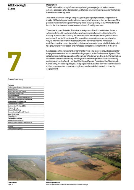
Description<br />
The £8 million Alkborough Flats managed realignment project is an innovative<br />
scheme addressing flood protection <strong>and</strong> habitat creation in compensation <strong>for</strong> habitat<br />
loss due to coastal squeeze.<br />
As a result of climate change <strong>and</strong> post glacial geological processes, it is predicted<br />
that by 2050 relative sea level could rise by up to half a metre in the Humber area. This<br />
poses a massive challenge to managing flood risks, especially as 90,000 hectares of<br />
l<strong>and</strong> in the Humber area is at or below the level of the highest tides.<br />
The scheme, part of a wider Shoreline Management Plan <strong>for</strong> the Humber Estuary<br />
which seeks to address these challenges, has specifically involved breaching the<br />
existing defences <strong>and</strong> flooding 440 hectares of intensively farmed agricultural l<strong>and</strong><br />
on the south bank of the estuary. The project is an example of a more sustainable<br />
way to address flood risk <strong>and</strong> at the same time demonstrates the concept of<br />
multifunctionality; breaching existing defences has created new wildlife habitats, led<br />
to agricultural diversification <strong>and</strong> increased recreational opportunities in the area.<br />
<strong>L<strong>and</strong>scape</strong> architects Maslen Environmental were employed to provide stakeholder<br />
engagement services <strong>and</strong> external funding support to the Environment Agency. The<br />
role also included the preparation of a number of external funding bids, the facilitation<br />
of stakeholder <strong>and</strong> partnership meetings <strong>and</strong> the development of local community<br />
projects such as the South Humber Wildlife <strong>and</strong> People Project <strong>and</strong> the Alkborough<br />
Community Archaeology Project. This project has illustrated how value can be added<br />
to flood management projects through successful stakeholder <strong>and</strong> community<br />
engagement.<br />
<strong>L<strong>and</strong>scape</strong> Institute<br />
<strong>L<strong>and</strong>scape</strong> <strong>architecture</strong> <strong>and</strong> the challenge of climate change