NL28 - Brussels International Map Collectors
NL28 - Brussels International Map Collectors
NL28 - Brussels International Map Collectors

You also want an ePaper? Increase the reach of your titles
YUMPU automatically turns print PDFs into web optimized ePapers that Google loves.
Also in this issue:<br />
May 2007 BIMCC Newsletter No 28<br />
BIMCC<br />
Newsletter No 28<br />
May 2007<br />
ISSN 1379-3306<br />
www.bimcc.org<br />
The Holy Land<br />
as seen by Christiaan van Adrichem<br />
1793-1864)<br />
• Caert-Thresoor, a minor atlas as title of a journal<br />
• Exhibition reports<br />
• Numerous book reviews<br />
• BIMCC programme for the Autumn 2007<br />
• … and the usual departments
2<br />
IRIS ANTIQUE GLOBES<br />
RESTORATION STUDIO<br />
Paul Peters B.V.<br />
Dorpstraat 31b<br />
7218 AB ALMEN<br />
Tel. +31 575 43 94 40<br />
Fax +31 575 43 39 73<br />
www.irisglobes.nl<br />
Large stock of historically important globes,<br />
armillary spheres, planetaria, maps.<br />
Restoration of paper, leather, vellum, charters.<br />
Paulus Swaen<br />
Internet <strong>Map</strong> Auctions<br />
March-May-September-November<br />
<strong>Map</strong>s, Globes, Views, Atlases,<br />
Prints<br />
Catalogue on: www.swaen.com<br />
E-mail: paulus@swaen.com<br />
Tel. +33(0)6 14 74 11 65<br />
Tel/Fax +33(0)1 44 24 85 80<br />
ANTIQUARIAAT PLANTIJN<br />
D.R. Duncker<br />
Meijsberg 12<br />
4861 BP Chaam<br />
Nederland<br />
Tel +31 16 149 20 08<br />
E-mail: dieter.duncker@planet.nl<br />
Old maps, prints, atlases<br />
and illustrated books<br />
Antiquariat<br />
Peter Kiefer<br />
Buch- und Kunstauktionen<br />
(Book and art auctions)<br />
Steubenstraße 36<br />
75172 Pforzheim, Germany<br />
Tel. +49 7231 / 9232-0<br />
Fax +49 7231 / 9232-16<br />
E-mail: p.kiefer@kiefer.de<br />
URI: http://www.kiefer.de/index.asp<br />
BIMCC Newsletter No 28 May 2007
EDITORIAL<br />
Dear <strong>Map</strong> Friends,<br />
For the second time, our Newsletter reaches the record size of 40 pages — about the maximum<br />
which I am ready to handle!<br />
One reason for this is the long study which our member, Stanislas De Peuter, has devoted to<br />
Christiaan van Adrichem. Starting from some remarkable maps in his collection (reproduced on the<br />
cover and centrefold of this issue), he has analysed in depth the contemporary cartographical<br />
representation of biblical stories and the special contribution made by van Adrichem in that field.<br />
A number of pages in this issue are also focused on BIMCC activities, past (our visits in Rotterdam,<br />
following the theme of our last Conference on ‘Charting the seas’, the recent Annual General Meeting<br />
cum <strong>Map</strong> Evening) and future (see the programme on page 30). Do not forget to register, both for the<br />
visit to the Belgian National Geographic Institute in September and, already, for the big<br />
event which we are busy organising in November with the Royal Library and Europalia !<br />
Cartographically yours,<br />
Contents<br />
Pictures at an exhibition<br />
I: Magna Regio (Luxembourg within a common region)<br />
II: Belgium on maps<br />
Places with maps<br />
The Geographical Panels in the Medici Guardaroba… revisited<br />
Quick Looks at books<br />
Shorter notes on five recent publications<br />
Caert-Thresoor, a minor atlas as title of a journal 13<br />
Christiaan van Adrichem—Initiation to the man, the book, the maps 14<br />
BIMCC News<br />
BIMCC Spring excursion to Rotterdam<br />
Annual Activity Report 2006<br />
BIMCC 9 th Annual General Meeting<br />
<strong>Map</strong> Evening<br />
Programme for the Autumn 2007<br />
Günter Schilder 65 years<br />
<strong>International</strong> news and events<br />
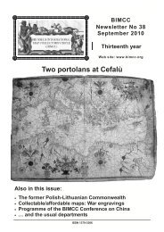
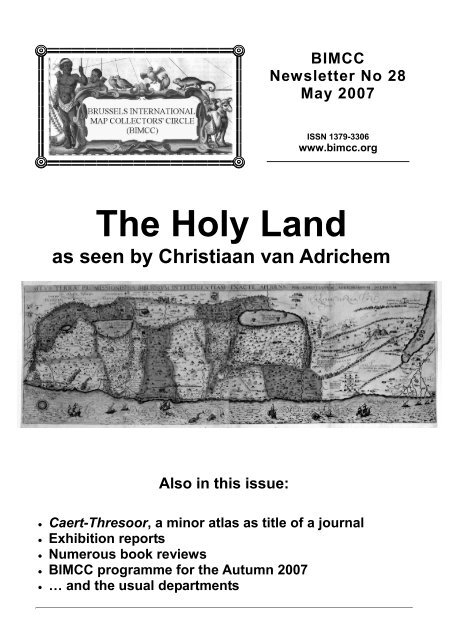
Cover: The Holy Land from the Bible as it really is, by Christiaan van Adrichem (see article, page 14).<br />
Jean-Louis Renteux<br />
Editor<br />
editor@bimcc.org<br />
Auction calendar 37<br />
Coming soon, Do not miss the next Newsletters 11<br />
May 2007 BIMCC Newsletter No 28 3 3<br />
4<br />
5<br />
6<br />
8<br />
24<br />
25<br />
26<br />
26<br />
30<br />
29<br />
32
PICTURES AT AN EXHIBITION (I)<br />
Magna Regio –<br />
Luxembourg et Grande Région : Cartes, Atlas, Vues<br />
Luxemburg und die Grossregion : Landkarten, Atlanten, Ansichten<br />
(Luxembourg within a Common Region: <strong>Map</strong>s, Atlases, Views)<br />
Exhibition of cartographic treasures from the private collection of Dr Tomasz<br />
Niewodniczański, sponsored by and held on the premises of Fortis Banque Luxembourg,<br />
Espace Royal Monterey, Boulevard Royal, Luxembourg, 27 March – 11 May 2007.<br />
Bi-lingual catalogue in French and German, 152 pp., 72 colour illustrations. Soft cover, 20 x 29 cm. To order : Fortis Banque Luxembourg,<br />
L-2951 Luxembourg, for the attention of Mr Patrick Doemer. EUR 25.00 plus postage of EUR 6.00 outside of Luxembourg<br />
There is simply no way of adequately sounding the<br />
depths of the marvellous collection of maps and<br />
atlases Dr Niewodniczański (Dr Niewo, as some<br />
privileged persons call him) has assembled over the<br />
past 35 years or so. Some of us have seen a<br />
significant part of this collection on the occasion of the<br />
October 2005 BIMCC excursion to Bitburg, and<br />
readers of this Newsletter may recall my review of the<br />
catalogue accompanying the historical exhibition in<br />
Warsaw (Newsletter No. 19, May 2004). And here we<br />
have another insight into the holdings of probably the<br />
most important private collection in Europe.<br />
This exhibition was staged, with the generous<br />
support of one of the biggest banks in Luxembourg,<br />
Fortis, in the context of Luxembourg and its Region –<br />
European Cultural Capital 2007. The declared aim of<br />
this major event adequately sets the scene also for<br />
this exhibition : across existing, now progressively<br />
symbolic boundaries, it brings together provinces of<br />
four countries with a population of over 11 million<br />
inhabitants, three languages, in five regions in the<br />
heart of Europe – Luxembourg town and country, the<br />
Lorraine (F), Rhineland-Palatinate (D), Saar (D), and<br />
Wallonia (B), with its French and German speaking<br />
communities.<br />
The vernissage on 26 March, organized in style by<br />
Fortis, brought together<br />
e m i n e n t L u x e m b o u r g<br />
personalities, an impressive<br />
crowd of interested patrons<br />
as well as some map<br />
historians, among whom<br />
Prof Günter Schilder and<br />
Hans Kok. It was a pleasure<br />
to meet again with Dr<br />
Niewo, his wife, and Dr<br />
Kazimierz Kozica who had<br />
assumed a large part of the<br />
exhibition preparation and<br />
catalogue. This wellconceived<br />
and beautifully<br />
illustrated publication merits<br />
being presented in some<br />
detail.<br />
After introductory notes<br />
by Carlo Thill, President of<br />
the Board of Directors of the<br />
B a n k , a n d b y<br />
4<br />
Dr Niewodniczański (seated) and his wife welcome<br />
Prof Günter Schilder at the vernissage<br />
(photo by D. Bodenstein)<br />
Dr Niewodniczański, who gives a brief overview of the<br />
selection presented, there follows a historical essay<br />
by the chief Librarian of the Grand Ducal Library, Gast<br />
Mannes. His analysis of the geo-political evolution of<br />
the ‘Common Region’ in the European context is a<br />
welcome lecture on cross-boundary social, cultural,<br />
and commercial endeavours of recent times. In the<br />
ensuing review of the representation of Luxembourg<br />
on maps generally, Mannes comments the earliest<br />
maps of Europe produced in the Ptolemaic tradition,<br />
not showing Luxembourg as such, then cites later<br />
maps with a toponymical mention of the Duchy, till<br />
the Duchy as a whole is presented in detail in maps<br />
from the second half of the 16 th century onwards. A<br />
brief section is devoted to town views of the city, and<br />
to the artistic dimension of some of the maps shown,<br />
referring in particular – you have guessed it – to the<br />
famous Leo Belgicus which has Luxembourg in one of<br />
his paws. This essay closes with a reflection on the<br />
prospects of modern cartography of the Region.<br />
In the following three sections we come to<br />
reproductions of maps shown in the exhibition.<br />
First are presented atlas title pages and maps of<br />
Luxembourg, including the ones by De Jode,<br />
Mercator, Ortelius, Blaeu, Janssonius, Visscher, plus<br />
a town view by Braun & Hogenberg, and a<br />
presentation of the first<br />
world map printed in two<br />
colours, by Bernardus<br />
Sylvanus, Venice 1511.<br />
Some town views (Braun<br />
& Hogenberg, Blaeu,<br />
Bonnart) are next, followed<br />
by 27 pages of map<br />
illustrations ranging from a<br />
world map of the Ulm<br />
Ptolemy edition of 1482 to a<br />
road map of the Duchy of<br />
1887. In between we find<br />
some absolutely stunning<br />
pieces : a map of Central<br />
E u r o p e b y M a r c u s<br />
Beneventanus and Bernard<br />
W apows k i ( 1507), a<br />
trapezoïd map of Central<br />
E u r o p e b y N i c o l a u s<br />
Cusanus, drawn by Nicolaus<br />
Germanus ca 1475, in its<br />
BIMCC Newsletter No 28 May 2007
PICTURES AT AN EXHIBITION (II)<br />
On the occasion of its 175 th<br />
anniversary, the Belgian National<br />
Geographic Institute (NGI)<br />
organised this exhibition which is<br />
now hosted by the Army Museum<br />
and has been prolonged until 15<br />
June 2007 (for details see the<br />
<strong>International</strong> News and Events<br />
department).<br />
This exhibition follows the<br />
same theme, and uses the same<br />
material, as the book published<br />
last year to mark the anniversary<br />
of the creation, in 1831, of its<br />
predecessor, the Dépôt de la<br />
Guerre et de la Topographie.<br />
They both show the profound<br />
evolution of Belgian landscapes<br />
over the last three centuries:<br />
extension of human habitat,<br />
c o n s t r u c t i o n o f r o a d s ,<br />
canalisation of rivers, changes in the use of land, etc.<br />
This evolution is illustrated thanks to the NGI<br />
important collection of ancient maps, generally using<br />
the Cabinet map of Count de Ferraris as the<br />
third state (ca 1530), a cartographical marvel in<br />
absolutely mint condition, then maps by Tramezzino<br />
(1553), Tielemann Stella (amazing circular map of ca<br />
1560), Michael von Aitzing, inventor of the Leo<br />
Belgicus (1583), Visscher’s world map and map of<br />
Europe, plus a few quite outstanding wall maps by<br />
Kaerius (1607), Blaeu (1612 and 1658), Mortier (1702<br />
and 1706), De Fer (1730), and Dezauche (1690).<br />
A very brief section on globes is devoted to one<br />
such piece on show, a terrestrial globe by Blaeu<br />
(ca 1621).<br />
The last chapter is a cartobibliographical comment<br />
by Dr Kozica on each of the exhibits illustrated on the<br />
preceding pages. This comment is particularly<br />
valuable because it goes well beyond a description of<br />
the maps shown: it also puts the exhibits into the<br />
context of the history of their production and that of<br />
related atlases or maps. A very thorough piece of<br />
research which qualifies this remarkable catalogue for<br />
a place in the reference library of any serious<br />
collector.<br />
Wulf Bodenstein<br />
wulfbo@scarlet.be<br />
La Belgique en cartes | België in kaart :<br />
l’évolution du paysage à travers trois siècles de cartographie | de evolutie van het landschap in drie eeuwen cartografie<br />
(Belgium on maps: the landscape evolution through three centuries of cartography )<br />
Royal Museum of Armed Forces and Military History, <strong>Brussels</strong> , until 16 June 2007 (new!)<br />
Parc du Cinquantenaire 3 | Jubelpark 3, 1000 <strong>Brussels</strong>, URI: http://www.klm-mra.be; http://www.ngi.be/expo/expo_fr.htm<br />
Book (same titles) by Phillippe De Maeyer, Marc Antrop, Christian Vandermotten, Marc Beyaert e.a., in French or Dutch, some 250 pp, 160<br />
colour illustrations, Tielt, Ed. Lannoo and <strong>Brussels</strong>, NGI/IGN, 2006, EUR 40.00 at the exhibition<br />
reference, then calling on<br />
Vandermaelen, maps produced<br />
by the Dépôt de la Guerre, by<br />
the Military Cartographic Institute<br />
and by the NGI itself, as well<br />
aerial photos.<br />
The exhibition essentially<br />
comprises reproductions of these<br />
maps, with the notable exception<br />
of an atlas by Nicolas Visscher<br />
opened at the page of Germania<br />
Inferior.<br />
This interesting overview of the<br />
evolution of Belgium in terms of<br />
rural, urban, industrial and<br />
touristic landscapes provides a<br />
welcome introduction to the<br />
planned BIMCC visit to the NGI in<br />
September (see page 30 for<br />
details).<br />
Jean-Louis Renteux<br />
j.renteux@scarlet.be<br />
May 2007 BIMCC Newsletter No 28 5 5
PLACES WITH MAPS<br />
In BIMCC Newsletter No 17 (September 2003)<br />
Wulf Bodenstein entertained us on the book Le<br />
trentacinque cartelle della Guardaroba medicea di<br />
Palazzo Vecchio – The Thirty-Five Scrolls of the<br />
Medici Guardaroba of Palazzo Vecchio in Florence<br />
which focuses on the cartouches of the panels in the<br />
Wardrobe and their texts. This report attempts to walk<br />
us through the Guardaroba itself of which some of its<br />
panels are true beauties for eye and mind.<br />
Is this not a strange place for geographical<br />
murals? Why such oeuvre in a second floor room<br />
which is clearly not one of the central places or<br />
showpieces of the palace? Why have these precious<br />
geographical presentations been painted on wooden<br />
panels of a Wardrobe<br />
which then operates as a<br />
depository of treasures?<br />
The Palazzo Vecchio<br />
long pre-dates the<br />
coming to power of the<br />
M e d i c i . S y m b o l i c<br />
monument of political<br />
power in Florence and,<br />
simultaneously, the most<br />
outstanding piece of civil<br />
architecture of the<br />
Florentine Trecento, or<br />
14 th c., this building was<br />
begun in 1299, to plans<br />
by Arnolfo di Cambio, as<br />
the Palazzo dei Priori.<br />
It became Palazzo<br />
della Signoria in the<br />
15 th c., and then the<br />
residence of the Medici<br />
from 1540 to 1565, when<br />
its name was logically<br />
changed in ‘Palazzo<br />
Vecchio’, the old palace,<br />
after the Grand Duke<br />
Cosimo I (1519 – 1574)<br />
shifted his residence to<br />
Palazzo Pitti.<br />
The Grand Duke ordered Vasari, an architect from<br />
Arezzo, to transform the building into a Palace. The<br />
Wardrobe had to place the things of most importance<br />
both in terms of worth and beauty which his<br />
Excellency owned (dixit Vasari). And so this room<br />
became a vast depository, not only for the Grand<br />
6<br />
The Geographical Panels in the Medici Guardaroba of Palazzo Vecchio<br />
Revisited<br />
Entrance to the Guardaroba<br />
Duke’s clothes but also for his silverware, jewels and<br />
other precious goods. The cabinets and carved ceiling<br />
are by Dionigi Nigetti. In my opinion the integration of<br />
the wooden wardrobe in a very large room with high<br />
ceilings is not an architectural success and does not<br />
appeal to our 21 st century notion of beauty. Grand<br />
Duke Cosimo I ordered that the doors of the<br />
cupboards should be painted with Ptolemy’s maps in<br />
oils, each one precisely measured and amended in<br />
accordance with the new authors and with accurate<br />
navigation maps (dixit Vasari).<br />
The geographical project was grandiose: 57 panels<br />
(14 each for Europe, Asia and America, 11 for Africa<br />
and the remaining four would complete the picture of<br />
the globe). In reality, only<br />
53 oil paintings were<br />
finished of which 12 cover<br />
E u r o p e , 1 6 A s i a ,<br />
9 America, 12 Africa and 4<br />
the North Pole. Padre<br />
Egnazio Danti 1 was<br />
responsible for 30 ‘doors’<br />
from 1563 to 1575.<br />
Meanwhile in 1574<br />
Francesco I had become<br />
Grand Duke of Tuscany<br />
and he replaced Danti by<br />
Don Stefano Buonsignori,<br />
an Olivetean monk, who<br />
finished another 19 panels.<br />
It is unknown who can<br />
claim the rights on the four<br />
panels of the North Pole<br />
and, finally, to complete the<br />
figure of 57, four panels<br />
were not even started.<br />
The first impression is the<br />
complete lack of structure<br />
and of uniformity in style<br />
and colouring. Gemmarosa<br />
Levi-Donati 2 thinks Vasari<br />
had ordered a geographical<br />
sequence, but that, in fact, the panels have probably<br />
been placed purely according to size. Thus, the visitor<br />
will not see any logical build-up of the geography of<br />
the panels. Concerning style and colouring, the<br />
Buonsignori panels are basically more in pastel<br />
(green, pink and yellowish) and they are embellished<br />
with wild animals, while the Danti panels breathe a<br />
___________________<br />
1) Danti would subsequently teach Mathematics and Spheres in Bologna, before starting on his masterpiece in the Vatican Museum (see<br />
Newsletter No. 26).<br />
2) Levi-Donati, G., Le tavole geografiche della Guardaroba Medicea di Palazzo Vecchio in Firenze – The geographical panels in the<br />
Medici Guardaroba of Palazzo Vecchio in Florence, Perugia, Benucci Editore, 1995, 141, no ISBN: the whole of Europe had to be on the<br />
right side as one enters.<br />
BIMCC Newsletter No 28 May 2007
yellow desert colour and show many mole-hills.<br />
The timing of the works more or less coincides with<br />
the first edition of Ortelius’ Theatrum Orbis Terrarum,<br />
which, without any doubt, excels the Guardaroba in<br />
terms of completeness and accuracy, although Danti<br />
already used the new cartographical system of<br />
Gerardus Mercator. He focused more on Asia (14<br />
panels) and America (8 panels), while Buonsignori<br />
devoted himself first to the European powers (Spain,<br />
Germany, France, Italy: 6 panels) and then continued<br />
with the African continent (10 panels). No North East<br />
America or Canada and, obviously, no Australia.<br />
From Danti we retain:<br />
• two panels dedicated to Natolia, one undated,<br />
the other dated 1565: maybe Danti wanted to<br />
substitute the undated clearly less accurate by<br />
the other more finished and detailed panel;<br />
• l’vltime parti note nel Indie occide(nta)li, or<br />
California anno 1564, before it became an island;<br />
• Thule (or Iceland) having a more than acceptable<br />
form and without sea-monsters;<br />
• an unfinished panel with the western tip of<br />
Gronladia, upon my first glance mistakenly seen<br />
as Cornwall, located by Danti almost entirely<br />
above the Circulo Artico;<br />
• an accurate Madagascar anno 1565, as<br />
circumnavigated several times in the early days<br />
and thus, well known: first data provided by<br />
Pedro Cabral in 1501 and first more or less<br />
reliable cartographic presentation by Pedro<br />
Reinel in 1507;<br />
• finally, if you happen to be in the vicinity and you<br />
are chased by the Comedy Capers, think of the<br />
Armenia panel: it serves as a secret door, … but<br />
I don’t know where it leads to.<br />
and from Buonsignori we retain:<br />
• Part(te) d’Affrica nuova, et Regno di Manicongo,<br />
anno 1580: central Africa with a large Lago di<br />
Zambare feeding the Zaire running straight west;<br />
• an untitled panel of the Magellan Straits with<br />
disproportioned location of the Rio de la Plata,<br />
the Lago de Titicacha and the Lago de Titicaza<br />
(can the latter be the smaller southern part of the<br />
main lake, also called the Lago Huiñaymarca?);<br />
• Mauretania, or North-West Africa, with the three<br />
ranges of the Atlas mountains correctly<br />
differentiated by the artist’s brushstrokes and the<br />
Canary Islands properly distanced from the<br />
coast;<br />
• a very detailed map of Germania, including - as it<br />
sometimes longed for in history - the<br />
Netherlands, most of Denmark and eastwards<br />
stretching to the plains of (let’s say) Kursk.<br />
L’vltime parti note nel Indie occide(nta)li<br />
(The ultimate part of the West Indies, i.e. California), 1564<br />
And last but not least, the history of a myth: the<br />
four unsigned and undated panels on the North Pole<br />
by a yet unknown author ; they make me think of the<br />
North Pole map by Mercator having the same<br />
structure and 4 rivers. One of the panels mentions<br />
‘Pigmei hic habitant quatuor ad summum pedes<br />
longi…’.<br />
From the little window in the wall (the only one in<br />
the room), it is reported that Cosimo I meticulously<br />
spied on his ministers and officers, during their<br />
meetings in the grandiose Salone dei Cinquecento —<br />
probably not a comfortable idea for those involved.<br />
Last century the Guardaroba underwent two<br />
restorations (in 1909 and in 1956), but new<br />
preservation measures seem to be required:<br />
woodworms are having a good time in virtually all<br />
panels. Not to miss, dominating the centre of the<br />
Wardrobe, stands a single huge globe, unfortunately<br />
also in a very bad state, possibly due to excessive<br />
restorations. Originally, it was planned that an earth<br />
globe and a celestial sphere would hang from the<br />
ceiling.<br />
Finally, around the corner from the Palazzo<br />
Vecchio lies the Museo di Storia della Scienza (which<br />
is almost entirely focused on Galileo’s scientific<br />
instruments) housing on its second floor a magnificent<br />
collection of globes most of which are by Blaeu 3 and<br />
the superb, but at the same time embarrassingly<br />
neglected world map by Lopo Homem, anno 1554.<br />
Stanislas De Peuter<br />
stanislas.depeuter@gmail.be<br />
3) on this collection: Dekker, Elly, Catalogue of Orbs, Spheres and Globes, catalogue of the collection at the Museo di Storia della Scienza,<br />
Firenze, Giunti, 2004, 19.5 x 26.5 cm, ISBN 8809035895. Bilingual Italian-English.<br />
May 2007 BIMCC Newsletter No 28 7 7
QUICK LOOKS AT BOOKS<br />
Shorter notes on five recent publications<br />
by Wulf Bodenstein<br />
This column, started in the last Newsletter, allows us to highlight and to document recent<br />
publications which, mainly for reasons of space, are not the subject of a ‘normal’ review under Looks<br />
at Books. These smaller publications and catalogues of exhibitions tend to pass unnoticed, being<br />
somewhat in the shadow of the bigger cartographic events, partly perhaps on account of the regional<br />
if not local character of the subject, or because of the relative remoteness of the publisher.<br />
And yet these publications offer a wealth of information relevant to the history of cartography. We will<br />
therefore continue to present them in an endeavour to put on record what might otherwise be<br />
confined to within national or institutional boundaries of competence, and language.<br />
400 Jahre Johannes Mejer (1606-1674) –<br />
Der grosse Kartograph aus Husum<br />
(400 years Johannes Mejer (1606-1674) –<br />
The great cartographer from Husum)<br />
by Oswald Dreyer-Eimbcke<br />
Oldenburg (D): KomRegis Verlag, 2006. 96 pp., 33 col. &<br />
47 b/w ill., soft cover, 24 x 17.5 cm.<br />
ISBN 3-938501-12-x. EUR 19.00.<br />
As announced in BIMCC Newsletter No 26 last<br />
September, this little book accompanies an exhibition<br />
held from 27 September 2006 to end of February<br />
2007 at the Maritime Museum of Northern Friesland<br />
in Husum, Schleswig-Holstein. Mejer, about whom<br />
rather little is known, comes to life again under<br />
Dreyer-Eimbcke’s prolific pen that transcribes for us<br />
his dedicated research on another one of those<br />
cartographers claimed by different nations. He was<br />
born in Husum in 1606, at a time when the Duchies<br />
of Schleswig and Holstein belonged to the Danish<br />
Crown.<br />
Educated in Copenhagen, Mejer returned to his<br />
home province and spent the ten years from 1638 to<br />
1648 surveying it. In 1652 he published his first atlas,<br />
Newe Landesbeschreibung der zwey Herzogthümer<br />
Schleswich und Holstein (New Topography of the two<br />
Duchies of Schleswig and Holstein), with the help of<br />
the brothers Dankwerth who financed the project, and<br />
the brothers Petersen and Lorenzen who engraved<br />
the maps. It contained 39 maps and 52 town views,<br />
but was a financial disaster.<br />
His further surveys of coastal areas, especially<br />
those of the western shores of the country, exposed<br />
to the furies of the North Sea that constantly modified<br />
the maritime borders, together with his basic maps of<br />
Schleswig, Holstein, Heligoland and other parts of<br />
Denmark up to Danish Iceland and Greenland,<br />
served as models for most of the later Dutch and<br />
German cartographers’ maps of that region. In 1657,<br />
the widow of Caspar Danckwerth, publisher of<br />
Mejer’s first atlas, sold the copperplates to Joan<br />
8<br />
Blaeu for the ridiculous sum of 360 thalers. Joan<br />
Blaeu used 32 of these plates for his Atlas Maior<br />
(1662), and adapted a few others in different formats.<br />
Towards the end of his extremely active and<br />
productive life Mejer encountered failure and defeat,<br />
largely due to financial misfortunes. At last the<br />
monumental work accomplished by Mejer, often<br />
discredited during his lifetime, largely ignored later,<br />
and still not well known today, is given full recognition<br />
by Dreyer-Eimbcke on these very dense, well<br />
researched, and nicely illustrated pages.<br />
W.B.<br />
BIMCC Newsletter No 28 May 2007
Das neu entdeckte Schlaraffenland –<br />
Johann Andreas Schnebelins Erklärung der wunder-seltzamen Land-<br />
Charten UTOPIAE aus dem Jahre 1694<br />
(The newly discovered Land of Cockaigne –<br />
Johann Andreas Schnebelin’s explanation of the wondrous map of UTOPIA of the year 1694)<br />
by Franz Reitinger (ed.)<br />
Bad Langensalza (D) : Verlag Rockstuhl, 2004. 336 pp., 55 b/w ill., hard cover 21 x 15 cm. ISBN 3-936030-38-3. EUR 29.80. A facsimile<br />
of the corresponding map issued by Homann (46.6 x 54.7 cm) is also available, ISBN 3-932554-60-4.<br />
To order : Verlag Rockstuhl, Lange Brüdergasse 12, D-99947 Bad Langensalza, Fax +49-3603-81 22 47, www.verlag-rockstuhl.de<br />
Occasional departures from<br />
the rigorous precepts of map<br />
making that required focusing<br />
on ‘what is where, or supposed<br />
to be there’, have been a<br />
recurrent feature that goes<br />
back many centuries. <strong>Map</strong>s of<br />
imaginary lands and seas were<br />
p o p u l a r a m o n g t h e i r<br />
contemporaries and have<br />
become subjects of serious<br />
study as well as cherished<br />
collector’s items.<br />
One such map was<br />
published by the Homann Heirs<br />
in Nürnberg between 1724 and<br />
1739 under the title Accurata<br />
Utopiae Tabula. The book<br />
discussed here contains a<br />
detailed description and<br />
interpretation of the provinces<br />
of this Utopian land, and of the<br />
features and mores of their<br />
inhabitants. To make the<br />
original text readable Reitinger<br />
has transcribed it from German Gothic into our current<br />
characters. In his commentary he demonstrates that<br />
the author must have had before him a precursor of<br />
the Homann edition since the geography described in<br />
1694 entirely matches the later map.<br />
Admittedly, to really appreciate this publication you<br />
would need a pretty good command of German,<br />
without which the hilarious puns and allegories would<br />
escape you. Not surprisingly, this text with its<br />
sometimes outrageous equivocalness pleased the<br />
ones as much as it irritated others, a sure formula for<br />
success. Among the nineteen<br />
provinces, many of which are<br />
given their names in Latin, you<br />
find Bacchanalia, Mammonia,<br />
Avaritia, and a Magni Stomachi<br />
Imperium.<br />
Using what I would call a<br />
Nicolosi globular projection, the<br />
anonymous map maker has<br />
drawn what looks like a<br />
conventional map of a large<br />
continent spreading across the<br />
equator from the northern to the<br />
southern polar circle. However,<br />
he has taken some impertinent<br />
l i b e r t i e s w i t h n o r m a l<br />
geographical rules: he places<br />
Jerusalem at the top of the map<br />
(does this ring a bell ?), at<br />
about 65° North, in a country<br />
called Terra Sancta Incognita,<br />
the land of the Chosen People,<br />
has a Cap Bonae Spei a bit<br />
further to the West, and puts<br />
other real features randomly<br />
across the map, in a good mix with the imagined<br />
ones, such as the islands of Tobago and Timor, a<br />
Terra Labrador and many others. He draws his<br />
curves of longitude from 360° in the West to 550° ( !)<br />
in the East. In his most fertile imagination he calls the<br />
southernmost town Satan, at about 70° South, in the<br />
Principatus Tenebrarum.<br />
Such is the land of hope and despair, of idleness,<br />
luxury and vice, a land to visit and get lost in.<br />
W.B.<br />
P.S. I have only just discovered, by accident, the existence of a world-wide Schlaraffia Society which appears<br />
to be very active in Germany and the German communities in many countries abroad, including Belgium<br />
(visit www.schlaraffia.org, contact <strong>Brussels</strong>-based Mr M. Voelzow, voelzow@gmx.de and see<br />
www.brucsella.os-home.de/heim/start.html).<br />
May 2007 BIMCC Newsletter No 28 9 9
QUICK LOOKS AT BOOKS (CONT’D)<br />
Les Globes de Coronelli<br />
(Coronelli’s Globes)<br />
by Hélène Richard<br />
Paris : Bibliothèque nationale de France / Seuil, 2006. 80 pp., 47<br />
colour and 4 b/w ill., hard cover 22 x 22 cm.<br />
ISBN BNF 2-7177-2372-2, ISBN Seuil 02-088141-1. EUR 20.00.<br />
www.bnf.fr<br />
Measuring nearly 4 m in diameter and weighing<br />
2.3 tons each (23 tons with their pedestal), the pair of<br />
celestial and terrestrial globes made in 1683 by<br />
Vincenzo Coronelli are what might be called one of<br />
the wonders of ancient cartography. They were<br />
ordered by Cardinal d’Estrées and presented to<br />
Louis XIV, King of the then most flourishing monarchy<br />
of the world. The fact that they have survived at all<br />
during these more than three hundred years, having<br />
been moved seven times to different places of storage<br />
and exhibition, is quite astonishing, especially if one<br />
realizes that, on occasion, the northern and southern<br />
hemispheres were dismantled for transport, with their<br />
supports completely removed. They are now exposed<br />
in Paris at the Bibliothèque nationale de France (BnF)<br />
Tolbiac (François Mitterand) site, for everyone to see<br />
and admire.<br />
It is on this occasion that Hélène Richard, Director<br />
of the Department of <strong>Map</strong>s and Plans of the<br />
Bibliothèque nationale, offers us a concise and well<br />
illustrated description of these fascinating globes, as<br />
much an encyclopedia of the world of the late 17 th<br />
century as a masterpiece of the art of the baroque.<br />
Whilst the terrestrial globe’s main attraction is the<br />
particularly rich collection of text cartouches<br />
commenting a world with which map collectors are<br />
relatively familiar, the celestial globe provided a<br />
unique opportunity, due to its size, to present the<br />
constellations and their allegorical representations in<br />
hitherto unknown artistic detail.<br />
If you do not possess the CD-ROM on Les globes<br />
de Louis XIV produced by the Bibliothèque nationale<br />
in 1999 1 , here is a welcome introduction to these<br />
outstanding creations by an outstanding cartographer.<br />
10<br />
André Vanden Eynde<br />
Rue de Stassart 59 · 1050 <strong>Brussels</strong><br />
Tel. +32 (0)2 514 40 47<br />
<strong>Map</strong>s, prints, views<br />
of all parts of the world<br />
Specialist in plans and views of<br />
<strong>Brussels</strong><br />
In addition you may read the article by Monique<br />
Pelletier in Tours et Contours de la Terre , a<br />
‘Festschrift’ published on the occasion of her<br />
retirement in 1999 from the post that Hélène Richard<br />
now occupies 2 .<br />
Vincenzo Coronelli (1650-1718) and his œuvre<br />
were paid tribute to by the Bibliothèque nationale in a<br />
conference on 22 and 23 March 2007 in Paris. Many<br />
well-known historians, among whom Monique<br />
Pelletier, Christian Jacob, Marica Milanesi, Elly<br />
Dekker, Frank Lestringant, Catherine Hoffmann,<br />
Hélène Richard and Zsolt Török exposed their views<br />
on map and globe making of that time, interpreted the<br />
cartography on the globes and talked about the quite<br />
incredible curriculum vitae of the globes. Particularly<br />
fascinating I found the scientific examination of the<br />
globes’ fabrication, inside and out, and the rapport, by<br />
Alain Roger, Head of the restoration department of<br />
the BnF, on the rehabilitation of these cartographic<br />
monuments. On the evening of the first day, Hélène<br />
Richard offered a commented tour of the globes in<br />
their new place of exhibition – if you get to Paris, don’t<br />
miss paying them a visit ! We will present a review of<br />
the proceedings of this conference when they become<br />
available.<br />
Another occasion to become familiar with Coronelli<br />
arises during the 11 th Symposium of the <strong>International</strong><br />
Coronelli Society, to be held in Venice from 28 to<br />
30 September 2007 – please see our <strong>International</strong><br />
News department.<br />
W.B.<br />
1) Les Globes de Louis XIV – La Terre et le Ciel par Vincenzo<br />
Coronelli (The Globes of Louis XIV – the Heavens and Earth of<br />
Vincenzo Coronelli), CD-ROM, Paris : Bibliothèque nationale de<br />
France, 1999<br />
2) Tours et Contours de laTerre – Itinéraire d’une femme au cœur<br />
de la cartographie (Shapes of the World , around the World –<br />
itineraries of a Lady at the Heart of Cartography), Paris : Presses<br />
de l’école nationale des Ponts et Chaussées, 1999<br />
BIMCC Newsletter No 28 May 2007
Modelle von Erde und Raum<br />
(Models of Planet Earth and Space)<br />
by Rudolf Schmidt<br />
Edited by Herwig Guratzsch of the Stiftung Schleswig-Holsteinische Landesmuseen, Schloss Gottorf<br />
(Foundation of Museums of Schleswig-Holstein, Gottorf Castle), 2007.<br />
99 pp., 85 colour and 20 b/w ill., soft cover, 23 x 17.5 cm. No ISBN.<br />
To order : Stiftung Schleswig-Holsteinische Landesmuseen, Schloss Gottorf, D-24837 Schleswig,<br />
Tel +49-(0)4621-8130 Fax +49-(0)4621-813.555, www.schloss-gottorf.de. EUR 11.80 plus shipping.<br />
Our readers may remember a short note in BIMCC<br />
Newsletter 23, p. 23, on the reconstruction of the giant<br />
Gottorf globe (Ø 3.11 m) which was unveiled in May<br />
2005. Since then over 50 000 visitors have come to see<br />
this 1:1 duplicate of the original 17 th century globe with a<br />
fascinating history.<br />
Earlier this year the advisors for this project, Prof<br />
Rudolf Schmidt, former President of the Coronelli<br />
Society, and Heide Wohlschläger presented over<br />
70 pieces from their impressive collection of globes in<br />
Vienna, at a special exhibition in the Gottorf castle<br />
(4 February - 29 April 2007).<br />
This attractive little book was published to accompany<br />
the exhibition and offers a concise introduction to the<br />
representation of the earth, the planetary system and the<br />
constellation of stars. Perceptions of the universe from<br />
antiquity to the 19 th century are illustrated with armillary<br />
spheres, permitting also a gentle reminder of some basic<br />
facts and rules that govern the movements of the<br />
heavenly bodies. Following a general appraisal of the<br />
concepts of celestial and terrestrial presentations, Rudolf<br />
Schmidt devotes a few chapters to the production of<br />
globes in the Netherlands, Italy, France, Germany,<br />
England, Sweden, North America and Austria. Some<br />
genre paintings and vanitas still-lives with globes round<br />
off the excellent series of illustrations.<br />
W.B.<br />
Coming soon<br />
Do not miss the next Newsletters!<br />
J & W Cary, Cary’s New Terrestrial Globe, Ø 30 cm,<br />
You will find, in particular:<br />
• Book review: Fra Mauro’s <strong>Map</strong> of the World, by Piero Falchetta. This masterpiece of western European<br />
cartography has not been the subject of a modern thorough study since an Italian publication in 1806. The<br />
present book aims at an analysis and an in-depth study of this unique world map, offering an understanding<br />
within its contemporary cultural framework.<br />
• Book review of Facsimile edition of a Portolan Atlas of 1546 by Battista Agnese, a splendid reproduction of<br />
this famous atlas held in the Russian National Library, Saint Petersburg.<br />
• ‘Monday, this must be Prague’: In this article, four reference books on city maps are reviewed, each<br />
approaching the subject matter differently. Peter Whitfield presents the global picture as he describes the<br />
history of a few world cities in general. Paul Cohen and Robert Augustyn focus on the Big Apple and tell us<br />
its (cartographic) history in detail. Thereafter follows a Tudor beauty offered by Jeffrey John Speed – all in<br />
the family. And to finish, a short visit of Milano.<br />
• ‘(<strong>Map</strong>s on) the legend of Prester John’: Although many of us are familiar with maps on which the legendary<br />
kingdom of Prester John is mentioned, few people actually know the legend behind. This article searches<br />
for the empire of Prester John and why the map of this empire was included in atlases of the most famous<br />
mapmakers of their time.<br />
May 2007 BIMCC Newsletter No 28 11 11
QUICK LOOKS AT BOOKS (CONT’D)<br />
Von der gemalten Landschaft zum vermessenen Land<br />
(From the painted landscape to surveyed lands)<br />
by Gerhard Leidel<br />
Generaldirektion der Staatlichen Archive Bayerns (General Directorate of the Bavarian State Archives), Munich, 2006. 312 pp., 106 colour<br />
and 5 b/w ill., hard cover, 21 x 23 cm. ISBN 10 3-938831-00-6. EUR 20.00. To order : Generaldirektion der Staatlichen Archive Bayerns,<br />
Schönfeldstrasse 5, D-80539 München,<br />
Tel +49-(0)89-286.38-2482 Fax +49-(0)89-286.38-2615, e-mail poststelle@gda.bayern.de, www.gda.bayern.de<br />
The Bavarian Central<br />
State Archives in Munich<br />
possess some 14 000 manuscript<br />
maps dating from<br />
ca 1470 to the beginning of<br />
the 19 th century. This is one<br />
of the largest and most significant<br />
collections of such<br />
maps in Germany. The book<br />
presented here is the catalogue<br />
of an exhibition of<br />
over one hundred maps and<br />
documents related to surveying,<br />
mounted by the<br />
State Archives from 6 October<br />
to 22 December 2006.<br />
Following an introduction<br />
by map curator Gerhard<br />
Leidel, who retired following<br />
this last major project, the<br />
catalogue follows the chronological concept of the<br />
exhibition : Part 1 is devoted to the Middle Ages, Part<br />
2 develops an interesting comparison of methods of<br />
spatial representation from landscape painting to<br />
scientific surveying, using as an example a particular<br />
12<br />
Cartographica Neerlandica<br />
The Ortelius Specialist<br />
Soestdijkseweg 101<br />
3721 AA Bilthoven<br />
Tel. +31 30 220 23 96<br />
E-mail: info@orteliusmaps.com<br />
www.orteliusmaps.com<br />
stretch of the River Inn,<br />
whilst the 12 chapters in<br />
Part 3 illustrate the evolution<br />
of ‘mapping’ from early paintings<br />
to large-scale maps<br />
and aerial photography.<br />
These 230 pages form the<br />
main body of the catalogue,<br />
offering a description and<br />
analysis of a great number<br />
of manuscript maps, all in<br />
excellent colour reproduction.<br />
At the same time we<br />
are introduced to painters,<br />
map makers and surveyors<br />
not so well known abroad,<br />
excepting Philipp Apian, and<br />
Tobias Volckmer perhaps.<br />
With this attractive and<br />
scholarly catalogue we are<br />
given an unprecedented view of Bavaria in former<br />
centuries, with maps presented to the public for the<br />
first time.<br />
Elisabeth Hermans<br />
Old <strong>Map</strong>s and Prints<br />
Grand Sablon 8 - 9<br />
Grote Zavel 8 - 9<br />
1000 <strong>Brussels</strong><br />
Tel. +32 11 31 17 19<br />
Fax +32 11 31 66 96<br />
Mobile 0475 61 38 53<br />
W.B.<br />
BIMCC Newsletter No 28 May 2007
HISTORY OF CARTOGRAPHY (I)<br />
Caert-Thresoor<br />
A minor atlas as title of a journal<br />
Our friends of the North have published an<br />
outstanding journal for 25 years in the Dutch<br />
language. One is familiar with the title of their journal,<br />
but tends to forget the origin of this title, although it<br />
reflects the international cartographic interests of the<br />
founders.<br />
The title ‘Caert-Thresoor’ is derived from the<br />
minor atlas ’Caert-Thresoor’ of 1598<br />
by Langenes. A work that is<br />
considered as a reference.<br />
Langenes is not the initiator of<br />
minor atlases of the 16 th and 17 th<br />
century. The Spiegel der wereld by<br />
Filips Galle had already been edited<br />
by Christoffel Plantin in 1577<br />
followed by the Epitome du Theâtre<br />
du monde and the Epitome Theatri<br />
Orteliani by Galle and the Plantin<br />
Press. Zacharias Heyns published<br />
Le miroir du monde also in 1598.<br />
The other minor atlases all date<br />
after Langenes: the Epitome Theatri<br />
Orbis Terrarum by Jan van<br />
Keerbergen, the Epitome by Jan<br />
B.Vrients and the several Mercator’s<br />
atlases minores by C.Claesz.,<br />
J.Hondius and J.Janssonius. His<br />
work became ‘the standard’<br />
characterised by an up-to-date<br />
content and a quality engraving. At<br />
the end of the 16 th century Amsterdam was the centre<br />
of geographical information. The publisher gave<br />
priority to the maps ; the texts were derived from the<br />
cartographic content.<br />
Barent Langenes, a printer of Middelburg<br />
(Zeeland), is the organizer of the Caert-Thresoor<br />
minor atlas, which he dedicated to the states of<br />
Zeeland. The format was of the oblong type,<br />
measuring on average 11x18cm, although these<br />
measures differ slightly throughout the 9 editions. It<br />
was primarily edited in Dutch and later in Latin,<br />
German and French and contained approximately<br />
170 maps measuring 8x10 (12) cm.<br />
Although the atlas was reprinted during many<br />
years by different publishers, it remained known as<br />
the ‘Langenes’ atlas.<br />
The first editions, 1598-1599, were published in<br />
the Dutch language. The writer of this text remains<br />
unknown. The Dutch text was revised in the 1609<br />
edition by Viverius under the title Handboek of Cort<br />
begrijp der Caerten. Soon the atlas was published<br />
and translated into French by Corn. Claesz. in 1600.<br />
The minor atlas was reprinted several times by<br />
different publishers in different languages but based<br />
on the Dutch text. One notes a 1600 French edition<br />
by de la Haye, and another in 1609 by Becker. In<br />
1612 there appears a German edition and in 1637 a<br />
Latin one by W.J.Blaeu.<br />
C.J. Visscher used the main bulk of the ‘Langenes<br />
maps’ supplemented with new engravings in a minor<br />
atlas of his own in 1649.<br />
Zeeland map from the ‘Langenes’” atlas<br />
The text was rewritten in Latin in a publication in<br />
1600 by Petrus Bertius and reedited in 1602-1606<br />
under the title P.Bertii Tabulae Geographicae<br />
Contractae. This second category was edited three<br />
times, namely in 1600, 1602 and 1606.<br />
From 1616 J.Hondius edited the work with new<br />
maps and with the revised text by Bertius. The 1618<br />
edition was translated into French. Many ‘Langenes<br />
maps’ were also used by editors in other<br />
geographical works. Finally J.Janssonius offered in<br />
1650 a German edition of the Hondius corrected<br />
atlas.<br />
One can only agree with C. Koeman and P. van<br />
der Krogt that Langenes set a standard for the edition<br />
of minor atlases.<br />
Eric Leenders<br />
Bibliography: Koeman’s Atlantes Neerlandici, New<br />
Edition, P. van der Krogt, Westrenen, Tuurdijk -<br />
't Goy-Houten (NL), HES & De Graaf, 1997-2006.<br />
May 2007 BIMCC Newsletter No 28 13 13
HISTORY OF CARTOGRAPHY (II)<br />
Sixteenth Century Biblical Cartography<br />
‘Historical’ maps could arguably be defined as<br />
maps which depict a period anterior to the time of the<br />
drawing and engraving. In the 16 th century there were<br />
basically two types of historical cartography: Greek-<br />
Roman and religious (read: biblical) maps. Ortelius’<br />
Parergon is sometimes acclaimed as the pinnacle<br />
example of historical cartography combining both<br />
genres.<br />
Outside the scope of this presentation are the pre-<br />
16 th century T-O 1 and other world maps on most of<br />
which Jerusalem is pictured as its centre 2 . Moreover,<br />
in those early days no real distinction between<br />
religious and non-religious mapping was made.<br />
Although the Holy Land is, geographically, a part of<br />
Asia, its history, then and now, has brought it closer to<br />
Europe; formerly, as part of Ptolemy’s early world,<br />
later as part of the Crusaders’. Logically, afterwards,<br />
sixteenth and seventeenth century biblical<br />
cartography mainly focused on maps of the Holy Land<br />
14<br />
Christiaan van Adrichem<br />
Initiation to the man, the book, the maps<br />
When the printing business knows its first boom in the 16 th century, science and religion are in a<br />
turmoil. Christiaan van Adrichem represents the New Man searching for biblical-historical truth while<br />
still being bound to medieval prejudices. This article presents this man and his book, Theatrum Terra<br />
Sancta which combines a historical study of the bible with a fantasy-rich mind for religion and geography.<br />
His two major maps, which several centuries later have become standards in their own right,<br />
are discussed in some detail: the Holy Land map (which is reproduced on the cover of this Newsletter)<br />
and Jerusalem’s map which is our ’<strong>Map</strong> of the Season’.<br />
Holy land, Münster, 1540 (first woodcut)<br />
and of Jerusalem 3 during the era of the Old and New<br />
Testaments or as accepted by later Christian tradition.<br />
One of the earliest biblical maps of these modern<br />
times was the map on the desert travels by the Jewish<br />
people in the so-called Zwingli bible printed by<br />
Christof Fro(h)schauer in 1525 in Zürich. Where<br />
current-day Christians tend to focus more on the New<br />
Testament world, in particular on the four evangelists,<br />
this was obviously not the case centuries ago, where<br />
the ‘Old’ Testament as God’s ‘story’ was given at least<br />
equal footing to the ‘New Testament’. As the scope of<br />
religious cartography is rather limited, its maps are<br />
often found as additions in atlases or they are<br />
published in bibles or religious works as embellishing<br />
illustrations. In the latter c ase the<br />
author/publisher/editor was often not a ‘professional’<br />
cartographer, but rather a bible specialist whose<br />
contribution to cartography was often concentrated on<br />
one or a few maps. Most of them are not well known<br />
in cartographic circles: Willem Vorsterman, Jacob van<br />
Liesveldt, Hendrik Peetersen, to name but a<br />
few, are earlier examples of these bible experts.<br />
In this era of Reformation and Counter-<br />
Reformation, a distinction can be made between<br />
Catholic and Protestant Christian works: for the<br />
former group beautification was essentially<br />
achieved by prints of biblical scenes in abundant<br />
baroque style, while Protestants often limited the<br />
‘joy’ of reading to maps, thereby remaining<br />
within the political correctness of their religious<br />
belief. It also comes as no surprise that desert<br />
travel was a popular symbol with the Protestants<br />
as they recognized it as their own breaking of<br />
the catholic chains (e.g., the illustration in the<br />
Zwingli bible).<br />
With the advent of the printing press, the<br />
spread of education and the proliferation of<br />
printed Bibles, the number of books about the<br />
Holy Land dramatically increased. At the same<br />
time they became a necessary source of<br />
knowledge about that region, since modern<br />
1) In medieval T-O maps (e.g. the Hereford <strong>Map</strong> c. 1300), the world was represented as encircled by the Ocean (’O’), with the east at the<br />
top and Jerusalem generally assumed to lie at the center of the circle; the ’T’ in the middle represented the Mediterranean, dividing the<br />
three continents, Asia, Europe and Africa.<br />
2) e.g. the cloverleaf World <strong>Map</strong> by Heinrich Bünting (1545 – 1606).<br />
3) To a lesser degree biblical maps show us Paulus’ and Abrabam’s peregrinationes (travels).<br />
BIMCC Newsletter No 28 May 2007
Christian pilgrimages only<br />
started a few centuries later.<br />
And so it happened that this<br />
rather unimportant land and<br />
city in the sixteenth and<br />
seventeenth century world<br />
incited many ‘cartographers’<br />
t o p r o d u c e a n<br />
unproportionally high quantity<br />
and variety of maps of which<br />
many have come to us. A fine<br />
and early example of a<br />
printed Holy Land map is the<br />
one by Sebastian Münster in<br />
his Geographia of 1540.<br />
As man meets God in a<br />
place which has become<br />
more an idea than a real<br />
location, a fine feature of<br />
most biblical mapping is its<br />
imaginary character as<br />
o p p o s e d t o r e a l i s t i c<br />
cartography (e.g., Hartmann<br />
Schedel) . Moreover, many of<br />
the religious maps were just<br />
illustrations to accompany a<br />
holy story (sometimes for an<br />
illiterate target group who<br />
wanted to see the maps<br />
‘confirming’ their ideas), so it<br />
comes as no surprise that<br />
their creators were not necessarily apprehensive<br />
regarding ‘realistic’ picturing: geographic proportions<br />
with accurate perspective were not the objective,<br />
rather transmitting the Christian message and<br />
ideology. Customarily, many biblical maps have no<br />
scales, but instead artistic drawings of bible scenes. A<br />
side-effect of this feature is the anachronistic<br />
picturing: events from different locations and times are<br />
located side by side to create one global impression<br />
for the readership. The end result is a glimpse of how<br />
European Christians perceived Jerusalem a few<br />
centuries ago.<br />
Finally, although three of the world’s great religions<br />
venerate the Holy Land and Jerusalem as the key<br />
place of this close encounter between man and God,<br />
it goes without saying that western sixteenth and<br />
seventeenth century religious cartography is limited to<br />
the Jewish 4 and Christian faiths being present in this<br />
region. Islam, the third monotheistic religion for which<br />
Jerusalem also is a holy city, is completely absent<br />
from this cartography. Ironically, at a time when these<br />
biblical maps were produced and published, the city<br />
and the land were under Ottoman control!<br />
The oldest map of the city of Jerusalem, Schedel<br />
(Nuremberg Chronicles of 1493)<br />
The man<br />
Christiaan Cruys van Adrichem (Adrichomius), one<br />
of the most famous representatives of biblical<br />
cartography 5 , perfectly fits in the above description of<br />
the non-professional historical-biblical map makers.<br />
Christiaan’s middle name was ‘Crucis’ or ‘Cruys’, so<br />
given to him since his father worked as a brewer in a<br />
Delft brewery called ‘Het dubbele Kruis’ (‘The double<br />
cross’), when he was born in that place on<br />
13 February 1533. He studied theology in Leuven,<br />
was ordained in 1566, and appointed Director of the<br />
Convent of St. Barbara 6 in Delft till expelled by the<br />
storm of the Reformation. Van Adrichem had to leave<br />
Delft in 1572 and settled in Cologne, where he served<br />
as prior of the Augustine monastery ‘Nazareth’.<br />
During that time, Cologne was a thriving centre for<br />
cartography and atlas publishing. As van Adrichem<br />
was interested in the topography of the Holy Land, he<br />
collected material from the Bible, histories, writings of<br />
pilgrims and travel accounts, some of which were<br />
subsequently lost. Thanks to this labour, he left us two<br />
major works: Vita Jesu Christi 7 (Antwerpen, 1578) and<br />
Theatrum Terrae Sanctae et Biblicarum Historiarum<br />
(‘Theatrum’) (Cologne, postmortem 1590). Van<br />
Adrichem died on 20 June 1585 in Cologne. It is<br />
4) Yaaqov ben Abraham Zaddiq and Abraham bar Yaaqov published maps of the same region with Hebrew lettering, respectively in 1621<br />
and 1695. More recent Jewish mapmakers include Aaron ben Hayyin of Grodno, Avigdor Mordechai Malkov, Elijah ben Solomon Zalman<br />
and Ben Menachem.<br />
5) And a relative of the Dutch humanist Martin Drop<br />
6) The St Barbara Convent which was founded in 1401, was partly destroyed in 1536 by the great fire of Delft and serves now as a student<br />
home.<br />
7) published under the name of Christianus Crucis.<br />
May 2007 BIMCC Newsletter No 28 15 15
disputed whether van Adrichem made the journey to<br />
the Holy Land to collect his information ‘on the spot’<br />
and to prepare drafts for his plans: Wilco Poortman<br />
and Joost Augusteijn think he did, but this has been<br />
denied more recently by Zsolt Török.<br />
The book: contents, maps, editions, and<br />
sources<br />
The Theatrum, produced after more than 30 years<br />
of labour, is considered one of the first scientific works<br />
on the historical geography of the Holy Land. Clearly,<br />
the book of somewhat 280 pages is a historical study<br />
and not an atlas as it comprises only two large maps<br />
(which will be discussed in more detail below) and ten<br />
small ones. Three chapters can be distinguished:<br />
• a description of Palestine: van Adrichem opens<br />
with a description of the Holy Land according to tribe,<br />
accompanied by one large general map of the entire<br />
region and ten smaller maps depicting the territory of<br />
the tribes of Israel and the Exodus 8 .<br />
• a description of the antiquities of Jerusalem<br />
which he had published in 1585 as Urbis<br />
Hierosolymitanae ... descriptio. This description of<br />
Jerusalem was thereafter included in the Theatrum. It<br />
contains one large map of the Holy City which is<br />
described below.<br />
• a Christian chronology: the work is concluded by<br />
a Chronicon, a chronology of biblical events from the<br />
creation of the world till the death of the Apostle St<br />
John (AD 109).<br />
The two main sections on Palestine and Jerusalem<br />
are drafted in the form of long lists of bullet points:<br />
each having more than 250 numbers<br />
referring to events, names, and<br />
locations of the Old and the New<br />
Testament. All the twelve maps<br />
referencing to those numbers are drawn<br />
in function of the book and they carry or<br />
illustrate the text. Since Cologne was an<br />
important centre for refugees from the<br />
revolt in The Netherlands against Spain,<br />
van Adrichem met there with Frans<br />
Hogenberg who printed his work. The<br />
Theatrum was edited by Gerardus<br />
Bruyns 9 and probably first published in<br />
1590 10 by the Officina Birckmannica in<br />
Cologne. As the work was very popular<br />
subsequent editions were published in<br />
1593, 1600, 1613, 1628 and 1682 11 . All<br />
five editions till 1628 were issued by the<br />
same publisher and were page for page<br />
16<br />
Tribus Zabulon, Isachar, Et,<br />
Dimidia Manasse ... -<br />
Adrichomius C., Ca. 1602.<br />
re-editions. It was also translated in many languages<br />
(even in Chinese in 1637) and as late as 1857 into<br />
French.<br />
Although it is hard to believe that any scientific<br />
source as we now understand the term has been<br />
used, van Adrichem already provides a long list of<br />
sources at the end of his book: apart from the<br />
Scriptures, van Adrichem mentions (quite<br />
exceptionally generous for his time), inter alia, the<br />
classical sources Ptolemaeus, Josephus and<br />
Hieronymus, the pilgrims Burchardus of Mount Sion 12 ,<br />
William Frey and the cartographers Bernard von<br />
Breydenbach, Jacob Ziegler, Tieleman Stella<br />
Sigenens, Petrus Laicksteen, Georg Braun, Sebastian<br />
Munster and Gerard Mercator. Special reference must<br />
be made to the Spanish priest Benito Arias Montano<br />
(1527 – 98), whose insertion of biblical maps in his<br />
Communes et familiares Hebraicae linguae idiotismi 13<br />
(Plantin, Antwerpen, 1572) was groundbreaking for<br />
Catholic practice. Another key source, already<br />
mentioned, was Flavius Josephus (AD 37 – c. 100), a<br />
Jewish historian who was employed by the Romans to<br />
write about the history of Roman Palestine during the<br />
Jewish revolt of AD 60-70 (‘Jewish War’) and whose<br />
other major work is ‘Jewish Antiquities’. His works<br />
contain accurate geographic details based on<br />
personal firsthand observations. With respect to the<br />
chapter on Jerusalem, van Adrichem based his work<br />
also on sources which are now lost — for example the<br />
description of the Holy City by his brother-in-law<br />
Ysbrand Godfriedsz. His work remains important for<br />
the study of the history of Palestine and Israel.<br />
8) These ten maps are called: ‘Tribus Aser’, ‘Tribus Gad’, ‘Pharan deSertum’, ’ Tribus Ruben’, ‘Tribus Ephraim, Benjamin, et, Dan.’,<br />
‘Tribus Zabulon, Isachar, et, dimidia Manasse’, ‘Tribus Iuda’, ‘Dimidia Tribus Manasse’, ‘Tribus Neptalim’, and ‘Tribus Simeon’.<br />
9) He was canon at Deventer.<br />
10) Adams, however, lists an edition of 1589 (Adams A-184).<br />
11) The 1682 version was edited by Jodocus Henricus Kramer.<br />
12) Burchard, arguably his most important surveyor, however, had died almost three hundred years earlier.<br />
13) This work might be considered as a Biblical dictionary, if only the data were put in alphabetical order.<br />
BIMCC Newsletter No 28 May 2007
‘Situs terrae promissionis ss bibliorum intelligentiam exacte aperiens: per<br />
Christianum Adrichomium Delphum’<br />
(The Holy Land from the Bible as it really is, by Christiaan van Adrichem from Delft)<br />
This large map of the Holy Land (reproduced on<br />
the cover of this Newsletter) is actually a synopsis of<br />
the nine smaller and more detailed maps of the Tribes<br />
of Israel and of the map of the Exodus. Oriented with<br />
the east at the top, this map (31 cm x 100 cm) shows<br />
the whole of Palestine, divided into the 12 tribes from<br />
the Mediterranean Sea, passing the Jordan River until<br />
the Seir Mons and the Galaad Mons; north-south, the<br />
shoreline runs from Sidon to Alexandria.The Nile Delta<br />
ends in one and the same straight line with the rest of<br />
the coastline, following Mercator and Sanuto 14 (but<br />
against Ziegler, Stella, Lafreri and Wissenburg, all<br />
bending the coastline towards Egypt). The Mare<br />
Magnum Quod et Mediterraneum, in which Jonas and<br />
the whale are found, is elegantly handwritten at the<br />
bottom of the map. On the top side of the map, the<br />
Jordan River, crucial then and now, and sourced by<br />
the brooks ‘Jor’ and ‘Dan’, dominates the water<br />
system by feeding the lakes. Cities are denoted by<br />
clusters of buildings and castles by a spire with a flag<br />
(Belfort, Agaba, Saba, etc.). Nebenzahl also mentions<br />
that the ‘V’ identifies the five cities of Satrapy, the<br />
seats of the Persian territorial governors; the asterisk<br />
locates the seats of the Levites, the priests of ancient<br />
Israel; and an ‘X’ indicates the cities of the Decapolis,<br />
the ten Roman administrative centres.<br />
As mentioned before, scenes of the Old and New<br />
Testaments intermingle. So, in one time and space we<br />
see Moses’ crossing the Red Sea, his zigzagging<br />
exodus through the desert, where the tabernacle is<br />
placed amidst the 12 tribes, and his climbing of the<br />
Sinai Mons. A bit further, the Gulf of Aqaba is<br />
absent 15 , so that Petra lies on the southern tip of the<br />
Dead Sea! In the Dead Sea, four burning cities of<br />
Pentapolis are shown: Sodoma, Gomorra, Seboim,<br />
and Adama - which united with Segor, resisted the<br />
invasion of Chodorlahomor, King of Elam (a country<br />
east of the Tigris). On the shores of the Dead Sea is<br />
the now fashionable resort of Engaddi, where David<br />
sought refuge when he fled from Saul. Van Adrichem<br />
calls the Dead Sea’s narrow southern tip, ‘Lingua<br />
Maris’, the tongue of the Sea. He used the name<br />
which was originally given by Josephus in Roman<br />
times and later Burchard in the Middle Ages (dixit<br />
Nebenzahl).<br />
Centrally on the map, the capital of Jerusalem<br />
dominates Benjamin’s land with, linked by one of the<br />
few roads on the map to Hebron, capital of Tribus Iuda<br />
and somewhere half distance Bethlehem, birth place<br />
of Jesus. Outside Hebron stands the oak of Mamre<br />
where Abraham lived. A bit further we discover<br />
Herodes’ palace on ‘Matsada’, which is actually more<br />
famous for the historic Zealot resistance under<br />
Eleazar Ben Yair and their defeat against the Romans<br />
that took place in AD 70 – 73. In Tribus Isachar the<br />
Van Adrichem, Holy Land: detail of Moses’ journey<br />
through the desert, with the Red Sea and the Nile delta<br />
strategic crossroads of the plains of Meggido often<br />
served as focus point for heroic battlefields. On the<br />
border of Isachar’s tribe with Tribus Zabulon we find<br />
the River Cison erroneously linking the Mare Galilleae<br />
(hosting many apostolic fishermen) with the<br />
Mediterranean Sea. The picturing of contemporary<br />
vessels by van Adrichem is a typical anachronism on<br />
historical maps 16 . Finally, obligatory hungry seamonsters<br />
swim the waves.<br />
Van Adrichem specifically names his sources for<br />
the geography of the Holy Land such as Peter<br />
Laicksteen, Christian Sgrooten and Tieleman Stella. It<br />
is likely that for this particular map he also used<br />
geographical models, such as the Palestine map by<br />
Jacob Ziegler of 1532 or the ‘Tabula moderna –<br />
Tabula sancta’ map of Claudius Ptolemaeus of 1513,<br />
or even an earlier version of 1482 published by<br />
Leonardus Holle. Curiously, van Adrichem does not<br />
mention Marino Sanuto as one of his sources,<br />
although his map closely resembles the Sanuto-<br />
Visconte delineation and he must have been familiar<br />
with Sanuto’s map as it was included in many editions<br />
of Ptolemaeus. According to Nebenzahl, Sanuto’s<br />
information had become increasingly obscure at van<br />
Adrichem’s days, while Burchard’s account gained<br />
prestige.<br />
14) e.g. the cloverleaf World <strong>Map</strong> by Heinrich Bünting (1545 – 1606).<br />
15 ) The absence of the Gulf of Aqaba seems to be a recurring feature in early carthography, such as we see in Münster's Holy Land map<br />
and in Ptolemy's map XIX from Codex Lat. V. F.32.<br />
16) The same to be admired on several Parergon maps.<br />
May 2007 BIMCC Newsletter No 28 17 17
‘Jerusalem et Suburbia eius. Sicut Tempore Christi Floruit’<br />
(Jerusalem and its Surroundings, as it Flourished in the Time of Christ).<br />
It is no exaggeration to state that this map<br />
(reproduced on the centrefold overleaf — as ‘<strong>Map</strong> of<br />
the season’) is a serious challenger for the prize of the<br />
most interesting biblical map of the Holy City. After an<br />
initial quick glimpse on this fascinating document<br />
(50.5 cm x 73.5 cm) dating 1585, its symmetrical<br />
structure strikes: Jerusalem is pictured as a rectangle,<br />
viewed from the west, liying on its long side and<br />
subdivided in three sections; a left quarter (north), a<br />
central half (diagonally crossed by a brook) and a right<br />
quarter (south). According to Rubin Rehav, this image<br />
of Jerusalem as a rectangle divided by walls into three<br />
main parts — north, central and south — was based<br />
on a misinterpretation of Flavius Josephus’ description<br />
of the city. In perfect balance with the religiously<br />
inspired cosmic world, the same divine symmetrical<br />
design appears in other plans of Jerusalem as well,<br />
some of which may be based on the simplified<br />
woodcut plan of Heinrich Bünting (anno 1581):<br />
although in square form, the Bünting map has the<br />
same three sections.<br />
The eastern (top) and southern (right) walls on van<br />
Adrichem’s map are framed by two rivers<br />
(respectively the Cedron and the Gion) joining in the<br />
top right corner, which is perfectly balanced by the<br />
Calvary Mountain in the lower left corner. The Temple<br />
and the Tabernacle take the central position on the<br />
map. City gates are placed at regular intervals. Above<br />
the City, three weapon shields (on the schematic<br />
drawing below marked by an ‘x’) dominate the top of<br />
the map: on the left the shield of Ernst, archbishop of<br />
17) Archbishop ‘Ernst von Bayern’ (1554 – 1612) was the son of Duke Albrecht of Bavaria and Anna of Austria. He was the first of the five<br />
Cologne Archbishops from the House of Wittelsbach. His period in office was from 1583 to 1612.<br />
18) This cross was the symbol of the Crusader Kingdom of Jerusalem, which existed for almost two hundred years after the First Crusade.<br />
The four smaller crosses are said to symbolize either the four books of the Gospel or the four directions in which the Word of Christ spread<br />
from Jerusalem. Alternatively or complementarily, all five crosses symbolize the five wounds of Christ during the Passion.<br />
19) The weapon on his shield is formed by an upwards twisting snake.<br />
20) and they varied in location as well<br />
21) St. Anne is known by tradition as being the mother of the Virgin Mary.<br />
18<br />
Γ<br />
Cologne 17 , in the middle the Jerusalem Cross 18 , and<br />
on the right the shield of Christiaan van Adrichem 19 .<br />
The Hebrew University of Jerusalem Web site<br />
shows van Adrichem’s map of Jerusalem with<br />
excellent browse and zoom functions. Please go to:<br />
http://maps-of-jerusalem.huji.ac.il/html/gallery3.html<br />
and we will walk over the detailed map and discuss<br />
some of its highlights. The numbers mentioned in this<br />
section refer to the captions in the map on the internet<br />
and they are, of course, identical to the numbers used<br />
by van Adrichem. As mentioned, he identified over<br />
250 sites and keyed them to his extensive descriptive<br />
text. As this map is the summum of anachronistic<br />
mapping, without distinguishing scenes of the Old and<br />
New Testament and even placing other historical<br />
events next to each other, the map is a pictorial<br />
synopsis of the Bible. Let’s now enter the city walls<br />
and wander around in space and time: from David’s<br />
City over the Stations of the Cross to the camps of<br />
various invasions of the Holy City.<br />
The eye-catcher is clearly the walled Temple<br />
dominating the central section where the high priest<br />
(number 85) stands in front of the Tabernacle or the<br />
Ark of the Convent with the menorah at his left (i.e. our<br />
right) and the table of the showbread at his right. The<br />
Ark is flanked by two Cherubim (angels) holding<br />
between them the name of God against a golden<br />
background. Just to the left of the Temple we discover<br />
the Antonia ‘Arx’ (number 29) and Pilate’s Palace<br />
(number 57) where the Way of the Cross starts.<br />
En passant, van Adrichem had a major influence<br />
on the Christian presentation of the Way of the<br />
Cross: he described the Via Dolorosa in 14<br />
Stations from the Antonia fortress to the Church<br />
of Holy Sepulcher where pilgrims pray(ed) from<br />
station to station. Prior to van Adrichem, the<br />
number of stations varied widely in number 20<br />
between 11 and 31, but after him the number of<br />
14 stations became a widely accepted standard<br />
for which he is given credit. The last five<br />
stations on the Mount Calvary (or Golgotha)<br />
(bottom left on the chart; numbers 250 – 254)<br />
are now located in the Church of the Holy<br />
Sepulchre (which is well within the current city<br />
walls). In the same central section one also<br />
comes across Solomon, David’s son, sitting on<br />
his Throne (number 113), Jacobus being<br />
beheaded (number 47), the House of Saint<br />
Anne 21 (number 37) and the Roman<br />
amphitheatre (number 28) to name but a few<br />
scenes.<br />
BIMCC Newsletter No 28 May 2007
Detail of Jerusalem map with the final Stations of the Way of the Cross on Mount Calvary<br />
For Rubin Rehav another kind of anachronism<br />
involves van Adrichem’s use of terms from his own<br />
time or from other periods. For example, the term<br />
forum rerum venalium (‘the market where [they] sell’)<br />
for the market place having number 47, is known to us<br />
only from the Crusader period as it was employed<br />
from the 12 th century onwards! So its use on this<br />
biblical map is misplaced. All in all, van Adrichem’s<br />
map is an invitation to leisurely study and reflect<br />
today, just as it was in the 16 th century. In the right<br />
part within the city rampart the Mons Sion Civitas<br />
David Qvae Est Svperior is located where one<br />
discerns, inter alia, the Palace of David on Mount Sion<br />
(number 3), but also Jesus’ trial before High Priest<br />
Caiafas (number 37), and even, the intimate<br />
‘Cenaculum’ or Last Supper (number 6). Finally, on<br />
the left, Bezetha 22 , the Upper City, with Herod’s<br />
immense palace (number 137). It goes without saying<br />
that in this fantasy décor, the buildings, structures,<br />
wall, towers and other fountains, many of which have<br />
been described in the Scriptures, mostly breathe a<br />
Renaissance architecture.<br />
Extra muros many things are happening too:<br />
almost every spot is creatively decorated. Starting at<br />
the left bottom corner with the Mount Calvary and<br />
going clockwise, political adversaries are besieging<br />
the city: Pompeius’ first century BC tent camp (number<br />
264), the Roman siege of AD 70 (number 267) and,<br />
the sixth century BC Babylonians’ camp (number 258).<br />
In the central top section, on or close to the Mount<br />
Olive, some scenes of Jesus’ life are presented, such<br />
as Jesus’ entry on Palm Sunday (number 214), his<br />
praying in Gethsemane (number 188), the betrayal by<br />
Judas Iscariot and the capturing of Jesus (number<br />
212), and a triumphal Ascension (number 192). Close<br />
to the romantic Cedron brook one detects the stoning<br />
of the praying Stephen (c. AD 33) (number 201) or the<br />
bloody sawing of Jesasas (number 225), or a bit<br />
further the winding road to Jericho with the peaceful<br />
village of Bethany (number 179) in a far distance. At<br />
the bottom part of the map Mount Gion with Herod’s<br />
first century BC ‘SPQR’ camp (number 259)<br />
dominates and next to it, on the road to Emmaus, two<br />
disciples stroll while ignorantly accompanying Him<br />
(number 257). Symbolically closing this review, as<br />
Jesus’ body lies on the opened cave at the foot of<br />
Mount Calvary in the left corner (number 239), Judas<br />
Iscariot commits suicide by coldly hanging himself on<br />
the tree at the outskirts of the city in the right bottom<br />
corner (number 234).<br />
22) ‘Bezetha’ called by Josephus the ‘New City’, suburb of Jerusalem, north of the Temple, which was outside the second but included<br />
within the third wall.<br />
May 2007 BIMCC Newsletter No 28 19 19
20<br />
‘Jerusalem et Suburbia eius<br />
(Jerusalem and its Surroundings, a<br />
By Christiaan<br />
BIMCC Newsletter No 28 May 2007
Sicut Tempore Christi Floruit’<br />
s it Flourished in the Time of Christ).<br />
van Adrichem<br />
May 2007 BIMCC Newsletter No 28 21 21
Influence and followers<br />
Where the replication of realistic maps is often<br />
disclosed through the reprinting of ‘mistakes’ or the<br />
general or individual structure of the map or parts<br />
thereof, the copying of fantasy maps is<br />
straightforwardly disclosed through the simple fact of<br />
their existence. As mentioned, the Theatrum was very<br />
popular, so that not only the book was re-edited<br />
several times after Christiaan’s death, but also his two<br />
principal maps were copied well into the nineteenth<br />
century, or at the very least, some cartographers were<br />
tributary to the ‘non-professional’ cartographer van<br />
Adrichem. In the end, it really seems that these maps<br />
have ‘solidified’ the cartographic understanding of<br />
biblical life.<br />
We list below a few of these followers (in<br />
alphabetical order):<br />
22<br />
View of Jerusalem by J. Janssonius, 1657,<br />
copied from van Adrichem, but turned 90°.<br />
BIMCC’s <strong>Map</strong> of the Season<br />
For the Jerusalem map:<br />
• Braun, Georg, and Hogenberg, Frans, Ierusalem,<br />
et suburbia eius, sicut tempore Christi floruit, cum<br />
locis, in quibus Christus passus est..., on two sheets in<br />
volume IV of the Civitates Orbis Terrarum, Cologne 23 ,<br />
1588; this is the best known copy of the map of van<br />
Adrichem, but turned 90° (and Braun signing the<br />
dedication himself!);<br />
• Déchaud, Etienne, Plan de Jerusalem du temps<br />
de N.S. Jesus-Christ, Lyon, 1586;<br />
• de Jode, Gerard, on two sheets, 1587 possibly<br />
used by Braun & Hogenberg 24 ;<br />
• Fleischmann, August Christian, Erster Abrissz der<br />
Stadt Jerusalem wie sie fuernemlich zur Zeit desz<br />
Herrn Christi beschaffen gewesen, Norib [i.e.<br />
Nuernberg], 1736;<br />
• Fuller, Thomas, Pisagh-Sight of Palestine,<br />
London, J. Williams, 1650 ;<br />
• Herz, Johann Daniel, Senior, Jerusalem,<br />
Augsburg, c. 1735;<br />
• Jaillot, Alexis Hubert, Hierusalem Saincte Cité de<br />
Dieu / Mis en lumière par H. Jaillot - Plan de la saincte<br />
Ville de Hiervsalem, de ses Faubourgs et lieux plus<br />
remarquables hors la Ville, Paris, 1678;<br />
• Janssonius J., Ierusalem, et Suburbia eius, sicut<br />
Tempore Christi Floruit, cum Locis in quibus Christ<br />
Passus ... Descripta per Christianum Adrichom<br />
Delphum, 1657 (see illustration on the left);<br />
• Langlois, Nicolas, L'ancienne ville de Hierusalem,<br />
Paris, 1640;<br />
• Plancius, Petrus, Jeruzalem, Amsterdam, c. 1604<br />
(to some extent tributary);<br />
• Sayer, Robert, An exact draught of the City of<br />
Jerusalem and the appurtenances belonging to the<br />
Holy Temple: with the Genealogy of Jesus Christ...<br />
faithfully collected out of the Holy Scriptures, c. 1770;<br />
• Seutter, Matthaeus, Ierusalem, cum suburbiis,<br />
prout tempore Christi floruit...juxta designationem<br />
Christiani Adrichomii delineata et aeri incisa per<br />
Matthaeum Seutter... Abriss der Weltberuehmten Statt<br />
Ierusalem, Augspurg, 1745; later edited by Tobias<br />
Conrad Lotter c. 1756;<br />
• van Deutecum, Johannes, Jerusalem die<br />
voornaemste van allen Steden, Haarlem, c. 1595;<br />
23) In some German editions the following text on both sides of verso is added: Jerusalem. Von Michael Eyzinger beschriben und<br />
illustriert. Eyzinger lived from c. 1530 to 1598. The Hogenberg map was also published by Jan Jansson.<br />
24) According to Bagrow (in Petermanns 1930) Braun & Hogenberg directly based themselves on van Adrichem’s map and not on the<br />
one by de Jode.<br />
BIMCC Members are invited to contribute and send to the editor proposals to present, on the central page<br />
of this Newsletter, a map which they particularly like and which they would like to share with other Members;<br />
it may be a map which has an interesting history or a curious anecdote attached to it, it may be the centre<br />
piece of your collection, it may be a map which you would like to bring to the attention of the cartographic<br />
community, etc.<br />
The Editor<br />
BIMCC Newsletter No 28 May 2007
• Verhelst, Jos, Das Alte Jerusalem ohngefehr<br />
entworfen, second half 18 th century.<br />
Another less successful and less baroque model<br />
for maps of Old Jerusalem is the one produced by<br />
Juan Baptista Villalpando (1552 – 1608) which was<br />
later copied by Halma (1709), Cornelis Danckaerts II,<br />
Matthaeus Seutter (1734) and Bachiene. The key<br />
feature of this representation is the rounder shape of<br />
the outer city walls in which a smaller circular inner<br />
city wall is pictured. Of course, not all maps of<br />
Jerusalem are purely virtual: Braun & Hogenberg have<br />
in their same Theatrum added a more down-to-earth<br />
map where Christian sites, Solomon’s temple and<br />
mosques coexist. Nebenzahl mentions that until the<br />
nineteenth century discoveries, this was the definitive<br />
layout of the Holy City.<br />
Followers of the Holy Land map are:<br />
• Briet, Philippe, Palestinae delineatio ad<br />
geographiae canones revocata, Paris, 1641;<br />
• de Wit, Frederick, Terra Sancta,<br />
sive Promissionis, olim Palestina,<br />
Amsterdam, 1690;<br />
• Halma, François, Terra<br />
Promissa, Amsterdam, 1709;<br />
• Janssonius, Palestina, sive<br />
Terrae Sanctae Descriptio,<br />
Amsterdam, 1631, with van<br />
Adrichem’s mistake re the Kishon<br />
River, however, also, with short and<br />
correct bend towards the Nile delta;<br />
• Tirinus, Jacobus, Chorographia<br />
Terae Sanctae in Angustiorem<br />
Fromamredacta et ex variis<br />
auctoribus amultis erroribus<br />
expvrgata, Antwerp, c. 1630;<br />
• Visscher, Nicolas, Terra Sancta,<br />
sive Promissionis, olim Palestina,<br />
Amsterdam, 1659.<br />
Final remarks<br />
The above exposé attempted to present a<br />
remarkable ‘cartographer’ of the sixteenth century.<br />
The symbolic importance of the location fed by<br />
religious imagination has resulted in two intriguing<br />
maps, full of hidden treasures. Both maps have more<br />
or less become standards in their own rights, and they<br />
now belong to the world heritage of biblical<br />
cartography. Many famous mapmakers were tributary<br />
to van Adrichem. The theologian appears in these<br />
maps as artist, as well as historian and teacher.<br />
Ironically, as we witness a general decline in<br />
historical-biblical knowledge, the maps regain their<br />
original educating function.<br />
Stanislas De Peuter<br />
stanislas.depeuter@gmail.be<br />
Situs Terrae Promissionis. S.S. Bibliorum intelligentiam exacte aperiens per Chr. Adrichom.<br />
- Janssonius J., c. 1658<br />
(Janssonius maps by courtesy of Brecht Devroe)<br />
Short list of principal sources on van Adrichem and biblical cartography in general<br />
• Nebenzahl, K., <strong>Map</strong>s of the Bible Lands – Images of the Terra Sancta through Two Millennia, New York,<br />
Abbeville Press, 1986, 164 pp., 39 x 30 cm, ISBN 0-89659-658-3.<br />
• Poortman, W.C., and Augusteijn, J., Kaarten in Bijbels (16 e – 18 e eeuw), Zoetermeer, Boekencentrum,<br />
1995, 273 pp. richly illustrated b/w, 30.3 x 21.5 cm, hard cover cloth bound, ISBN 90-239-1215-2.<br />
• Rehav, R., Fantasy & Reality, Ancient map of Jerusalem, found on a page (now deleted!) of the web site:<br />
http://members.bib-arch.org/<br />
• van der Sluys, W.G.J., Het Land van de Bijbel, Knokke – Utrecht, <strong>Map</strong>pamundi – Het Spectrum, 1986, 143<br />
pp. richly illustrated, 38.5 x 29 cm, hard cover cloth bound with dust jacket, ISBN 90-274-0556-2.<br />
• Török, Z., Szent Helyek a Térképeken - Sacred Places on <strong>Map</strong>s, Pannonhalma, Pannonhalma Archabbey,<br />
2005, 23.5 x 16 cm, paper back, ISBN 963-90-5367-8. Bilingual Hungarian-English.<br />
May 2007 BIMCC Newsletter No 28 23 23
BIMCC NEWS<br />
BIMCC Spring excursion to Rotterdam<br />
The Corpus Christi treasure<br />
(The exhibition of VOC sea charts)<br />
On 3 March 2007, Stanislas De Peuter had organized<br />
an extra BIMCC excursion at the ‘Maritiem Museum’<br />
in Rotterdam to visit the exhibition on the newly<br />
re-discovered charts of the Dutch East India Company<br />
(‘VOC’). Sjoerd de Meer, conservator, guided 20<br />
members to see the Corpus Christi sea charts.<br />
The VOC had charts drawn during their many voyages<br />
to the islands, but kept them secret. Somehow<br />
Thomas Turner, rector of the Corpus Christi College<br />
in Oxford, bequeathed in 1715 thirty unique sea<br />
charts to his college. Three hundred years later they<br />
were bought by the Maritiem Museum Rotterdam.<br />
The collection is a compilation of fourteen drawings<br />
on parchment and sixteen on paper. All are water<br />
coloured and well preserved. Eight of the parchment<br />
charts are the work of Joan Blaeu, who was the master<br />
cartographer of the VOC. The documents cover<br />
voyages to Indonesia, China, India and Sri Lanka<br />
(Ceylon).<br />
The VOC maps were hand drawn during these<br />
voyages, however they were finalized in Batavia or in<br />
Amsterdam under the leadership of Willem Janz.<br />
Blaeu. They were top secret and only lent out for the<br />
duration of one sailing trip and had to be returned af-<br />
24<br />
The Java sea, Blaeu, 1666<br />
ter each trip. These charts offer all kinds of information,<br />
sea routes, names of trading posts and specific<br />
notes.<br />
The exhibition itself looks like a small jewel box.<br />
Access to each chart is perfect. A giant video screen<br />
keeps the VOC spirit alive and details can be obtained<br />
on two separate small screens.<br />
To see so many VOC parchments,<br />
some even made by the master himself,<br />
is a must.<br />
The exhibition has been prolonged<br />
until 9 September 2007.<br />
Info at www.maritiemmuseum.nl<br />
(see also details in our events calendar<br />
at the end of this Newsletter).<br />
Eric Leenders<br />
ericleenders@scarlet.be<br />
BIMCC Newsletter No 28 May 2007
Johannes Vingboons’ Land in zicht<br />
(‘Land in sight’ exhibition)<br />
This exhibition of watercoloured maps by the 17 th<br />
century cartographer Johannes Vingboons took place<br />
at the Kunsthal in Rotterdam; a number of BIMCC<br />
members seized this rare opportunity to see cartographic<br />
top aquarelles from different museums.<br />
Johannes Vingboons was a map maker and<br />
painted hundreds of watercoloured views in his studio.<br />
He was briefed by sea men and reproduced what<br />
they saw from their ships during their voyages to the<br />
west and east. In fact, many pictures are a composition<br />
of different views. But mainly they offer us today<br />
what people saw centuries ago. This point was emphasized<br />
at the exhibition by comparing the photos of<br />
sites made by World Press Photo with the original<br />
aquarelles. Each watercolour is an attractive picture in<br />
itself. The colours are delicate and well chosen.<br />
Vingboons’ work consist of coloured drawings of<br />
coast outlines, townscapes, harbour plans and rivers.<br />
Two drawings of Hottentots illustrated the encounter<br />
of the VOC sea men with the indigenous inhabitants<br />
around the Cape of Good Hope.<br />
As a mapmaker he worked for J. Blaeu, chief cartographer<br />
for the VOC. He also drew maps for the<br />
West Indies Company (WIC) when travelling west.<br />
This explains the presence of many watercolours from<br />
the Asian Islands as from the Atlantic coast of America<br />
and Africa.<br />
J. Vingboons was influenced by engravings and<br />
watercolours in travel books. Jan H. van Linschoten<br />
who lived and worked in the Portuguese colonies inspired<br />
him. He did not all the work himself, but had a<br />
studio working for him.<br />
Annual Activity Report 2006<br />
Twenty-two active members attended the 8 th AGM<br />
meeting. The financial report and draft budget were<br />
discussed and adopted (See Newsletter No 25).<br />
Henry Godts retired as Vice-President and was<br />
replaced by Eric Leenders, who will temporarily cumulate<br />
this function with the post of Secretary.<br />
The Executive Committee met five times.<br />
The Newsletter developed progressively towards a<br />
journal with more substantial cartographic articles.<br />
Excursion to the University Library of Utrecht.<br />
Eighteen members joined on 13 October 2006 for a<br />
most interesting visit to the new map room at the University<br />
Library of Utrecht. Marco van Egmond, curator,<br />
guided us through the splendours of their collection<br />
(See report in Newsletter No 27).<br />
5 th <strong>International</strong> BIMCC conference on 9 December<br />
2006: Several speakers from four different countries<br />
explained to the 54 attendees their view on ‘Charting<br />
Osaka castle, Vingboons<br />
His decorative technique is characterised by pictures<br />
surrounded by a gold or a red border, fresh colours,<br />
depth creation by placing tree branches in the<br />
foreground and the presence of Dutch sailing ships.<br />
Four magnificent manuscript maps on parchment<br />
covering the world are a highlight at this exhibition.<br />
The amateurs of watercolours, of maps or bird’s<br />
eye views, were all delighted by this outstanding exhibition.<br />
Eric Leenders<br />
ericleenders@scarlet.be<br />
the seas – seven centuries of maritime cartography”<br />
(See report in Newsletter No 27)<br />
BIMCC also participated in the 5 th Paris <strong>Map</strong> Fair<br />
and the <strong>International</strong> Antiquarian Book Fair in <strong>Brussels</strong>.<br />
BIMCC started preparing the participation in Europalia<br />
(2007) programme with a conference and an<br />
exhibition organized in cooperation with the Royal<br />
Library of Belgium.<br />
Conclusion:<br />
BIMCC is a society whose activities remain, since<br />
the origin, in constant progress.<br />
Eric Leenders Wulf Bodenstein<br />
Vice-President President<br />
Secretary<br />
May 2007 BIMCC Newsletter No 28 25 25
BIMCC NEWS<br />
BIMCC 9 th Annual General Meeting<br />
28 April 2007<br />
B I M C C P r e s i d e n t W u l f B o d e n s t e i n<br />
welcomed.20 members of which 17 were ‘active<br />
members’ (i.e. with the right to vote).<br />
The Agenda was approved. The Annual Activity<br />
Report 2006 (see previous page) was presented, with<br />
the support of a slideshow, and was approved.<br />
Treasurer Pierre Mattelaer presented the financial<br />
report 2006. The receipt exceeded the expenditures,<br />
resulting, again, in an increase of the assets of the<br />
BIMCC. The President observed that the BIMCC had<br />
now reached its initial objective of accumulating<br />
reserves equivalent of one year of membership fees.<br />
The accounts were approved unanimously.<br />
Roland Delrue, who had worked closely with P.<br />
Mattelaer to ensure a smooth transition, presented the<br />
budget for 2007. The financial impact of the<br />
exceptional events planned with Europalia was<br />
discussed; the level of expenses will be higher than<br />
usual but will be compensated, in part, by extra<br />
income and subsidies; the deficit envisaged and<br />
associated risk were considered compatible with the<br />
BIMCC 9 th <strong>Map</strong> Evening<br />
28 April 2007<br />
Candidates, waiting to show their latest<br />
treasures, eagerly lined up when the <strong>Map</strong><br />
Evening started. Following the chronology<br />
of their maps, a wide variety of items was<br />
shown.<br />
Hercule Poirot….<br />
…otherwise known as Eric Leenders,<br />
was the first to speak, presenting a kind of<br />
mystery. The Mercator map of Flanders<br />
shows a small village, Vlasse(n)broek,<br />
peacefully lying then as today on the banks<br />
of the river Scheldt. Only, the thing is, it lies<br />
on the right riverbank, whereas Mercator’s<br />
map puts it on the left bank….Being so<br />
close to Rupelmonde, it is hard to believe<br />
Mercator could have made such a mistake.<br />
Eric tried to provide an explanation. There has<br />
been no change in the course of the river over the<br />
centuries, so that possibility is ruled out. Next, let’s<br />
look at the sources Mercator used for his map: the<br />
map of Brabant by van Deventer (without<br />
Vlassenbroek) and a 1538 map by Van der Beken,<br />
with Vlassenbroek on it, on the right bank. But since<br />
Van der Beken didn’t orientate his map with the north<br />
up, as Mercator did, it could easily be mistaken for a<br />
left bank village. So, continued our detective, it is very<br />
well possible Mercator ordered some helper to put<br />
Vlassenbroek, that he knew so well, on his map, but<br />
26<br />
current financial reserves of the BIMCC. The 2007<br />
budget was approved<br />
The President outlined the programme for 2007<br />
(see page 30), which is already well under way (see<br />
page 24, and the present report!). In particular, he<br />
gave details of the preparation of the Conference in<br />
the framework of Europalia.<br />
The AGM discharged the Executive Committee<br />
(EC) members.<br />
Some changes in the EC were announced. Pierre<br />
Mattelaer retires as Treasurer (but remains on the<br />
EC) and Johan Vanvolsem resigns from the EC. The<br />
AGM expressed appreciation for the good work they<br />
have accomplished over the years. The AGM<br />
approved the nomination of Roland Delrue as<br />
Treasurer.<br />
There were no new active member applications.<br />
E. Leenders looking for Vlassenbroek<br />
Jean-Louis Renteux<br />
editor@bimcc.org<br />
the helper held the Van der Beken map upside down<br />
and put Vlassenbroek on the left bank of the Scheldt!<br />
Flabbergasted and still considering the matter, we<br />
were already captivated by the next story about:<br />
Oh, non-island in the sun….<br />
Stanislas De Peuter showed a map of 1597,<br />
Granata Nova et California, by C. Wytfliet, from what<br />
is considered to be the first atlas of America, namely<br />
the Descriptionis Ptolemaicae Augmentum of 1597. It<br />
was published in Latin and in French. The map, as the<br />
BIMCC Newsletter No 28 May 2007
title indicates, shows California (American and<br />
Mexican) and it is probably based on 2 sources: the<br />
notes of Cortés and the ones of Fray Marcos de Niza:<br />
the former travelling by sea from the south (Vera<br />
Cruz), the latter overland, coming from Florida/Texas.<br />
The former was looking for islands, since his<br />
arrangement with the Spanish Crown implied he could<br />
keep those, the latter was looking for gold on behalf of<br />
the same Spanish King. Cortés landed on the<br />
ultimate south tip of Baja California, Cabo de Cruz, on<br />
3 May 1535. The same or another voyage travelled<br />
north in the same year, but had to return on what they<br />
called the Cabo de Engano (Cape of Deceit or False<br />
Point) as it still did not give way to an island after all.<br />
Wytfliet used this knowledge and indeed does NOT<br />
show California as an island. The island of California<br />
only came into ‘existence’ in cartography some 20<br />
years later. The overland mission confirmed the<br />
existence of another phantom story in cartography,<br />
i.e. the existence of the Seven Cities.<br />
A strange feature of the map is the Tropic of<br />
Cancer, running from the top of the map to the bottom<br />
(so apparently north-south), although the degrees of<br />
latitude, marked in the border of the map, are correct.<br />
Stanislas brought another Wytfliet map from the<br />
same atlas, i.e. of Central Canada. The map shows<br />
the same Seven Cities, the Iroquois ‘Hochelaga’ (or<br />
Beaver Lake) now Montreal and, unexpectedly, a<br />
large lake which is very similar to Lake Hudson, well<br />
before the first European set foot on its shores. Quid?<br />
The funny, the honest and the beautiful<br />
Hans Kok, in his efficient and knowledgeable way,<br />
produced three maps. First a very nice looking<br />
‘stripmap’ from the first half of the 17 th century by<br />
Ogilby. Those who, like me, want to find out more<br />
about the origin of the word and look up ‘strip’ in the<br />
Longman dictionary, will find different possible<br />
explanations, one of which (nr 3 for the interested) is<br />
in no way related to the subject, so don’t go looking<br />
for that kind of map on the market….Anyway, the map<br />
Hans brought shows the road from York to Whitby<br />
and Scarborough, more or less in the same way<br />
centuries earlier the Peutinger map did.<br />
Hans’second map was made by Coronelli, in 1692,<br />
showed the south part of Groenland, with the addition<br />
of the mysterious island of Frislanda. Coronelli writes<br />
it has been discovered by a Venetian, but in all<br />
honesty soberly adds that it must be either a ghost<br />
island or, otherwise, have sunk in the sea since<br />
then….<br />
Le Rouge made a map — Hans’ third — of New<br />
York City showing American and British troops in<br />
1776, the year of US independence. It was published<br />
both in London and Paris in the same year and carries<br />
names like ‘les provinciaux’ (meaning the Americans)<br />
and ‘general Clinton’ (commander of troups) that<br />
aroused some laughter among the audience.<br />
Loser<br />
The history of The Netherlands is both drawn with<br />
water and drowned in it (yes, yes, I looked it up!). This<br />
sometimes produces unexpected results and on this<br />
S. De Peuter and California<br />
<strong>Map</strong> Evening, we were shown a gem by Carrie van<br />
Loon, made as a commission from a waterschap (in<br />
Belgium known as watering). These institutions exist<br />
both in The Netherlands and Flanders since the<br />
Middle Ages and are as a matter of fact one of the<br />
oldest ‘democratic’ institutions there. They had (and<br />
today still have) to manage things like draining and<br />
damming etc in certain areas that had been<br />
impoldered. Voorne, south-west of Rotterdam, was<br />
such a waterschap, only then it was much bigger than<br />
today.<br />
Carrie showed the frontispiece of the Voorne<br />
Caertboeck, an atlas with 32 maps and no title page,<br />
made between 1695-1700 by A. Steyaart for tax<br />
purposes. The artists who made the cartouches are J.<br />
& C. Luyken. None other than Romeyn de Hooghe<br />
made and signed the frontispiece in 1701. It shows<br />
the coat of arms of the board of Voorne waterschap<br />
with the one of baron van Schagen, upper chairman,<br />
on top. The rest of the frontispiece (Carrie has a<br />
black&white version and a coloured one) shows a<br />
splendid allegory about the Dutch success in<br />
reclaiming land from the sea. One can see triumphant<br />
figures carrying the fruits of the land and the fight and<br />
defence against the sea with Neptune as the loser.<br />
Carrie, sportsmanlike, also rectified his contribution of<br />
last year, stating that the frontispiece he showed then<br />
turned out to be by Janssonius, made in 1620, and<br />
not as rare as the Blaeu of 1608 he thought it to be.<br />
New Sea discovered!<br />
Alex Smit brought the good tidings that a new sea<br />
had been discovered. That is, if you are willing to<br />
believe his map Amérique septentrionale divisée en<br />
ses principaux états of 1799. The map was part of an<br />
atlas, the Atlas moderne portatif, by Bertholon P. and<br />
Laporte J.<br />
The Americans will be proud to hear they have<br />
now got an inner ‘Western Sea’, the Mer de l’ouest,<br />
stretching as far as 1 000 km eastwards from the<br />
May 2007 BIMCC Newsletter No 28 27 27
coast of California and 1 700 km long (north-south)<br />
with many islands in it. The makers of the map must<br />
have had a rather wild imagination (and a rather<br />
limited knowledge of that part of the world, since the<br />
north and south are left a big void on the map) for<br />
they drew a passage to the Atlantic Ocean near the<br />
Arctic Circle, oblivious to the fact that it would only be<br />
gradually discovered during the 19 th century….<br />
Furthermore, their version of the Bering Strait, called<br />
Archipel Saint Lazare, bears no resemblance to the<br />
real strait.<br />
Sébastien Le Prestre de Vauban<br />
mort longtemps, toujours vivant<br />
This year is, as many of our readers will know,<br />
Vauban (1633-1707) year. Jean Petin brought a map<br />
made by the French Institut Géographique National<br />
on that occasion. It shows all the places Vauban<br />
worked at/on.<br />
Vauban’s preoccupation with making France a pré<br />
carré, surrounded by une ceinture de fer, is still very<br />
visible today in our landscape. Many fortified cities<br />
and indeed the whole Belgian south border owe their<br />
shape to his doings. No doubt this map will<br />
accompany you on your summer discovery<br />
expeditions….<br />
Small is….awful(?)<br />
Fay Huidekoper-Cope brought three 19 th century<br />
small items, which among other figures, all contained<br />
geographical information in the form of tiny maps<br />
(about 3x4 cm), qualified by Fay herself as<br />
‘quite awful’, though one could easily see why<br />
the little documents with their attractive colours<br />
appeal to many people. The first was<br />
published in Florence and apparently turned<br />
out to be a piece of a tarot set. It shows Arabia<br />
on the tiny map, surrounded by other figures,<br />
with numbers and a legend. The next one,<br />
from 1889, also bears a tiny map of the same<br />
region and was an advertisement for Arbuckle<br />
Coffee Company. Finally, the last one,<br />
advertising cigarettes, shows Persia and<br />
Egypt, with a description on the reverse side.<br />
Cartography that sticks<br />
Another possibility to display geographical<br />
information on a tiny surface: stamps. Johan<br />
Vanvolsem is the proud owner of an extensive<br />
stamp collection, focused on cartographical<br />
information. It is, in his own words: ‘an attempt<br />
for visual representation by means of world-wide<br />
stamps to underline the role and the importance of<br />
cartography’. Furthermore ‘the ambition was to show<br />
for the 205 independent states…one to 5 stamps in<br />
relation to these themes’. Johan produced a list of<br />
these stamps, far to long to reproduce here, but<br />
showing all kinds of historical, scientific, political etc<br />
information related to cartography. Impressive.<br />
3 Suisses for VIBs (very informed buyers)<br />
Jan De Graeve did not bring maps this time, but<br />
28<br />
books. Even recent ones. Indeed, as he<br />
demonstrated, the catalogues of big auction houses<br />
can be a very interesting source of knowledge on<br />
maps. These books show the auctioned items in<br />
colour, with descriptions etc and all for a modest<br />
price: who could ask for more? And don’t think there<br />
is nothing interesting on the market now: Jan claims<br />
the abundance of material surprises and some very<br />
rare items were recently sold — for a very handsome<br />
price —, like some 10 Ortelius atlases. He brought the<br />
catalogue of the auction of the Wardington Library<br />
(two volumes, full of geographical and cartographical<br />
material), that of the Earls of Macclesfield (Sotheby’s)<br />
and of the Streeter Library (2 vol, Christie’s): a good<br />
supply of interesting reading material.<br />
Two for the road<br />
To conclude, Hans Kok showed 2 more maps from<br />
his collection. The first, of 1930, a kind of historical<br />
and cultural heritage map of The Netherlands that<br />
was published as a supplement to the Haagsche Post<br />
(a Dutch news weekly). The second, of 1802, a<br />
Japanese one. It shows the bay of Nagasaki with the<br />
island Deshima where the Dutch were confined such<br />
a long time as the sole Western trade partners of the<br />
Japanese. It (the map, that is) is made of mulberry<br />
bark, very strong material, and is not orientated northsouth<br />
as Western maps, as the Japanese usually sat<br />
around their maps on the floor, so this didn’t make<br />
much sense. The words on it are all in Japanese, so<br />
we ended where we started that evening: with a<br />
mystery……<br />
Et nunc bibendum est<br />
As usual, after the formal map discussion,<br />
conversations continued around wine and snacks<br />
provided by Vice-President Eric Leenders, who<br />
doubled as barman, with the kind assistance of Lydia<br />
Gordon.<br />
Overall a very enjoyable evening. Thanks to all<br />
those who contributed to this success!!<br />
Caroline De Candt<br />
BIMCC Newsletter No 28 May 2007
Günter Schilder 65 years<br />
16 February 2007 was just two days short of the<br />
date, on which Prof. dr. G.G.R. Schilder reached the<br />
age of 65, in general considered the end of one’s<br />
active career. As Prof. Schilder has been a bit of a<br />
special professor indeed, holding his Chair in Historic<br />
Cartography for over 25 years at Utrecht University<br />
and acting as a catalyst in many ways in his field, the<br />
day was bound to be a celebration rather than a<br />
goodbye.<br />
Cleverly disguised as a regular ‘study-day’ for the<br />
GIN-Working Group for the History of Cartography,<br />
including a fake agenda, a group of friends around<br />
Mrs. Paula van Gestel had managed to lure a large<br />
number of people, both professional and amateur<br />
map friends, to the Navy Barracks, appropriately<br />
located next to the Netherlands Scheepvaartmuseum<br />
Amsterdam. Among the total of about two hundred<br />
participants were around twenty colleagues from<br />
abroad (Europe and North America), two<br />
ambassadors to the Netherlands (Austria and Malta),<br />
representatives of the Utrecht University and<br />
countless map friends of various denominations.<br />
Through smart planning, a little bit of luck and the<br />
cooperation of all involved, the programme remained<br />
a complete surprise to Günter Schilder, who had<br />
consistently interpreted all hints provided<br />
inadvertently, in the wrong fashion.<br />
Apart from receiving the just praise for his long<br />
career and outstanding publications (the on-going<br />
series Monumenta Cartographica Neerlandica being<br />
his Opus Magnum, no doubt), his exceptional<br />
Explokart project was highlighted. This project allows<br />
a high turn-over of research, executed by volunteer<br />
researchers, who are trained first at the University,<br />
complete their field work in small groups and prepare<br />
the results for publication under academic guidance<br />
and control. This helps bringing to light a large<br />
number of quality publications, without draining the<br />
meagre University funds. Its success is currently<br />
measured in over 14 000 pages in print and its weight<br />
at 140 kilograms so far, as Mrs. van Gestel reported,<br />
admitting that this unit of measurement seems<br />
uncommon in an academic sense.<br />
Günter Schilder was showered with praise by a<br />
number of speakers of renown, outlining his merits as<br />
a person and as an academic. Prof. Schilder received<br />
numerous presents amongst which a beautiful Liber<br />
Amicorum, <strong>Map</strong>pae Antiquae, featuring just under<br />
700 pages and beautifully illustrated, was the pièce de<br />
résistance, together with the -also unexpected-<br />
nomination on behalf of Queen Beatrix as Ridder in<br />
de Orde van de Nederlandse Leeuw (Knight of the<br />
Order of the Dutch Lion) for his outstanding academic<br />
performance. The Petrus Plancius medal, which is<br />
rarely awarded, was presented to him on behalf of the<br />
KNAG (Koninklijk Nederlands Aardrijkskundig<br />
Genootschap).<br />
For those worried about the future of historic<br />
cartography in the Netherlands, it may serve as a<br />
consolation that the Utrecht University provided a free<br />
Prof. Schilder at the last BIMCC conference<br />
five-year ‘stay-permit’ to its Austrian professor, which<br />
will enable him to maintain his office at the University<br />
for that period at least, in order to continue the many<br />
projects, awaiting completion.<br />
For those not worried about the future of historic<br />
cartography in the Netherlands, please consider the<br />
fact that Utrecht University lacks the funds to continue<br />
the special Chair and depends on private initiative to<br />
bring another professor of Historic Cartography, for<br />
which Chair a suitable candidate would be available.<br />
A CHC–Foundation (Cartographiae Historicae<br />
Cathedra) has been implemented, featuring a Board<br />
of Recommendation, with illustrious names indeed,<br />
and eager to arrange for the funds needed, although<br />
so far hardly successful. It would be of importance to<br />
enhance the international standing of all of the<br />
Seventeen Provinces of the Netherlands in terms of<br />
historic cartography, when we would succeed in<br />
supplying the money required for this purpose. I do<br />
not feel out of order, when I urge aficionados of early<br />
cartography to consider a donation to this foundation;<br />
a donation, which at least in the Northern<br />
Netherlands, would be tax-deductible, provided a five<br />
year commitment (or longer, if possible) is formally<br />
agreed. The amount of the donation would not be<br />
subject to the standard Dutch threshold (’drempel’) as<br />
normally applicable under the tax laws.<br />
For information, please contact:<br />
Stichting Cartographiae Historicae Cathedra<br />
c/o Mrs. Paula van Gestel- van het Schip<br />
Het Gewat 16,<br />
5258 KL Berlicum - The Netherlands.<br />
Tel.: +31 73 5037105 or +31 30 2531379<br />
E-mail: pjwvangestel@home.nl or<br />
p.vangestel@geo.uu.nl<br />
Hans Kok<br />
hanskok@introweb.nl<br />
May 2007 BIMCC Newsletter No 28 29 29
BIMCC NEWS<br />
BIMCC Programme for the Autumn 2007<br />
Friday 21 September 2007, 13.00 — 16.00<br />
BIMCC Autumn Excursion<br />
Visit to the Belgian National Geographic Institute<br />
(’Nationaal Geografisch Instituut (NGI) – Institut Géographique National (IGN)’)<br />
Shortly after the independence of Belgium in 1831 the Dépôt de la guerre et de la topographie was charged<br />
to make a survey of the country. The depot became in 1878 the Institut Cartographique Militaire or Militair<br />
Cartografisch Instituut. In 1947 the name changed to Institut Géographique Militaire/Militair Geografisch Instituut<br />
and became finally in 1976 the NGI-IGN, under the control of the Ministry of Defence.<br />
The survey of Belgium started with a triangulation scaled at 1:20 000 in 1850, with indications of the relief. A<br />
new triangulation was carried out in 1928. A topographical map 1:25 000 was realized between 1949 and 1970,<br />
followed by 1:50 000 and 1:10 000. Aerial photos were used in 1991 to produce a third basic survey at different<br />
scales. All these surveys led to the digital topographical maps. The 1:50 000 was used as a touristic map book<br />
published in 2005 by Lannoo.<br />
The Institute possesses also a collection of old maps of Belgium and part of the cartographic work by<br />
Eugène-Henry Frickx as well as by Count J. de Ferraris.<br />
The Institute is located in the historical building of a former<br />
abbey (Abbaye de la Cambre – Abdij ter Kameren 13, B1050-<br />
<strong>Brussels</strong>).<br />
The visit will be limited to 30 participants, and preference will<br />
be given to paid-up BIMCC Members. Non-Members may be<br />
admitted if places remain available after 1 September. All<br />
registrations will be dealt with on a first-come-first-served basis,<br />
and those accepted will be acknowledged by the Secretary.<br />
To register send the enclosed form (or the same information<br />
by e-mail) to the BIMCC Secretary before 1 September 2007.<br />
‘Abbaye de la Cambre’ ca. 1770, on the Ferraris map<br />
Every two years, since 1969, Europalia <strong>International</strong> organizes a major international<br />
multidisciplinary arts festival in Belgium to celebrate one country’s cultural heritage. The last<br />
event in 2005 received over one million visitors.<br />
In 2007, Europalia.europa will be the major arts festival marking the fiftieth jubilee year of the<br />
European Union. From 3 October 2007 until 3 February 2008, Europalia will play host to 27 guest<br />
countries and will present the culture of Europe and its 27 Member States in one spectacular<br />
cultural festival!<br />
The Royal Library of Belgium and the BIMCC have launched a joint programme consisting of an<br />
Exhibition and a Conference on the theme of Formatting Europe – <strong>Map</strong>ping a Continent which<br />
is now part of the official Europalia programme (see www.europalia.eu).<br />
30<br />
To be informed or reminded about BIMCC events<br />
send your e-mail address to info@bimcc.org<br />
BIMCC Newsletter No 28 May 2007
Friday 16 November 2007, 09.30 – 18.00 at the Royal Library of Belgium<br />
(Auditorium Lippens, Boulevard de l’Empereur 4, 1000 <strong>Brussels</strong>) :<br />
6 th <strong>International</strong> BIMCC Conference:<br />
Formatting Europe – <strong>Map</strong>ping a Continent<br />
Provisional programme<br />
Günter Schilder (Utrecht): Conference Chairman<br />
Angelo Cattaneo (Florence) :<br />
Europe in late Medieval and early<br />
Renaissance World <strong>Map</strong>s : Provincializing<br />
Europe<br />
Leena Miekkavaara (Tuusula, Finland) :<br />
Unknown Europe : the mapping of the<br />
Northern Countries by Olaus Magnus<br />
Krystyna Szykula (Wroclaw) :<br />
Anthony Jenkinson’s unique wall map of<br />
Russia (1562) and its influence on European<br />
cartography<br />
Peter van der Krogt (Utrecht) :<br />
European towns in Braun & Hogenberg’s<br />
town atlas<br />
Markus Heinz (Berlin) :<br />
Europe as seen by the Homann publishing<br />
firm in Nürnberg in the 18 th century<br />
Peter Barber (London) :<br />
Bringing the map to life : European satirical maps, 1845 – 1945<br />
Gilles Palsky (Paris) :<br />
Connections and exchange in European cartography : the example of 19 th century statistical maps<br />
Bernard Jouret (<strong>Brussels</strong>) :<br />
The space perception of the relief of Europe by contour lines : the remarkable work of J.-C. Houzeau, edited<br />
in 1857<br />
Please use the enclosed registration form and send it to our new Treasurer Roland<br />
Delrue before 15 October – not only does early registration offer admittance at a reduced rate<br />
(EUR 10.00 instead of EUR 15.00 at the door), but it also allows you to reserve your place at<br />
the traditional Speakers’ Lunch, and to subscribe to the proceedings of the Conference, to be<br />
published in 2008 by the Royal Geographic Society of Belgium.<br />
Further information from Wulf Bodenstein, Tel +00-32(0)2-772.69.09, wulfbo@scarlet.be<br />
Friday 16 November 2007, 18.30 (following the Conference)<br />
Official opening of the Exhibition of <strong>Map</strong>s<br />
Formatting Europe – <strong>Map</strong>ping a Continent<br />
in the Houyoux Hall, Royal Library.<br />
European cartographers have depicted Europe throughout the centuries in several ways : allegorically,<br />
physically, politically … Voluntarily or not, they sometimes took liberties with the reality. But this also was<br />
changing during the periods, specially relating to state borders. The exhibition will show maps from the Middle<br />
Ages to the 20 th century. The maps vary in aspect, aim and scale and have only one common feature: their<br />
subject. Grouped chronologically, they show the fascinating evolution of the continent and of its cartography.<br />
The exhibition will last until 8 February 2008, and a bi-lingual catalogue (Dutch, French) will be available.<br />
Further information from the Curator of the Exhibition, Wouter Bracke, Head of the <strong>Map</strong> Room at the Royal<br />
Library (Tel +00-32(0)2-519.57.43, wouter.bracke@kbr.be).<br />
May 2007 BIMCC Newsletter No 28 31 31
INTERNATIONAL NEWS & EVENTS Compiled by glenn.vandenbosch@azherentals.be<br />
News<br />
<strong>Brussels</strong> Royal Library new entrance<br />
Since the end of February 2007, the access to the<br />
KBR is through the new, modernised ‘Gutemberg’<br />
entrance. This is located at the end of the Mont<br />
des Arts garden, two levels below the former entrance<br />
(same address Bd de l’Empereur 4, B-1000<br />
<strong>Brussels</strong>). The new reception, next to a nice patio,<br />
comprises a number of computer terminals giving<br />
Events<br />
Warburg Lectures, London<br />
Nursery Instruction: Cartographical Novelties<br />
for Georgian and Victorian Children<br />
17 May 2007<br />
Jill Shefrin<br />
At University of London, Warburg Institute, Woburn Square,<br />
London WC1H OAB, at 17:00 pm. Enquiries to +44 (0) 20 8346<br />
5112 (Catherine Delano Smith) or Tony Campbell (email:<br />
t.campbell@ockendon.clara.co.uk) or visit http://<br />
www.maphistory.info/warburgprog.html<br />
Meeting Upper Canada <strong>Map</strong> Society<br />
The 1701 Samuel Clowes <strong>Map</strong> - Part of a Deed<br />
From the Iroquois to the King of England of a<br />
Vast Tract of Land.<br />
Toronto, Canada, 29 May 2007 Lecture on the ‘rediscovery’<br />
of the map and it's legal implications in<br />
the 21 st century Canadian courts. Speaker: Dr.<br />
Alexander von Gernet, Adjunct Professor of<br />
Anthropology.<br />
18:00-19:30 at the University of Toronto Robarts Library, Room<br />
4049, 130 St. George Street. Additional information from<br />
Megan Webster (webstermaps@sympatico.ca) or visit http://<br />
content.library.utoronto.ca/robarts.<br />
Seminar on Military surveying and mapping,<br />
Thatcham, Berkshire, UK, 2 June 2007<br />
In order to mark and celebrate the 80 th anniversary<br />
of the foundation of the Sound Ranging<br />
Association, the Defence Surveyors' Association is<br />
arranging a seminar to be held at the Royal School<br />
of Military Survey. The seminar will run from 10:00<br />
to 17:00 during which seven 35-minute<br />
presentations will be given.<br />
Lectures on:<br />
Three centuries of geographic support to the<br />
British Army,<br />
Acoustic Weapon Locating in the Great War,<br />
<strong>Map</strong>ping for the Third Battle of Gaza 1917,<br />
The Topographic <strong>Map</strong>ping of Hong Kong 1924,<br />
<strong>Map</strong>ping for the Falkland Islands War 1982,<br />
Sound-Ranging’s present-day equivalent and<br />
Military Geographic Support in Afghanistan<br />
2006-2007.<br />
32<br />
access to on-line catalogues and to registration facilities.<br />
Automatic lockers are located along the<br />
corridor giving acccess to the library proper. The<br />
<strong>Map</strong>s and plans department is directly at the end<br />
of that corridor.<br />
For a photograph of the new entrance, visit http://www.kbr.be/<br />
images/nvlle_entree/nvlle_entree_n_bl.jpg<br />
There will also be a display of maps of the<br />
Falklands War to mark its 25 th anniversary.<br />
For additional information contact Mike Nolan<br />
(maptnolan@googlemail.com) or Alan Gordon<br />
(editor@defencesurveyors.org.uk)<br />
<strong>International</strong> <strong>Map</strong> <strong>Collectors</strong>'Society, London<br />
8 June 2007<br />
Annual dinner at 19:30<br />
at East India Club, 16 St. James Square.<br />
9 June 2007<br />
10:30 Annual General Meeting<br />
Malcolm Young Lectures:<br />
13:00 Sarah Tyacke, All at Sea in the<br />
Renaissance.<br />
13:40 Yasha Beresiner, Back to Basics<br />
at Hand and Flower Function Room at 10:30), 1 Hammersmith<br />
Road, Kensington, Olympia. Additional information from IMCoS<br />
Secretariat (email: financialsecretariat@imcos.org) , Rogues<br />
Roost, Poundsgate, Newton Abbot, Devon TQ13 7PS, United<br />
Kingdom; fax +44(0)1364 631 042. http://www.imcos.org/<br />
Events_2006F.htm<br />
Annual London <strong>Map</strong> Fair, London<br />
8 - 9June 2007<br />
At Olympia 2 Exhibition Centre, Hammersmith Road.<br />
12:00-19:00 on 8 June and 10:00-17:00 on 9 June.<br />
Visit http://www.londonmapfairs.com/ or<br />
email: info@londonmapfairs.com for more information.<br />
22 nd <strong>International</strong> Conference on the History<br />
of Cartography (ICHC)<br />
Bern, Switzerland, 8 - 13 July 2007<br />
This biennial meeting is the major international<br />
scholarly conference dedicated to advancing<br />
knowledge of the history of cartography, of maps<br />
and mapmaking, broadly defined. The conference<br />
promotes global cooperation and collaboration<br />
among scholars (from any academic discipline),<br />
curators, collectors, dealers and institutions,<br />
through illustrated talks, poster presentations,<br />
exhibitions, and a social programme.<br />
Conference themes: mapping relief, maps and<br />
tourism, languages and maps, time as the<br />
cartographic fourth dimension.<br />
During the conference week, several exhibitions<br />
Note: the events are listed in chronological order (in case of a series of events, according to the first event in the series).<br />
BIMCC Newsletter No 28 May 2007
with a cartographic focus will take place in the city<br />
of Berne: in the Swiss Alpine Museum, the Swiss<br />
N a t i o n a l L i b r a r y , t h e S t a d t - u n d<br />
Universitätsbibliothek Bern (with Burgerbibliothek<br />
Bern). There will also be a series of professional<br />
visits (to the Federal Office of Topography and to<br />
the Staatsarchiv des Kantons Bern) as well as<br />
post-conference tours.<br />
Bern University, UniS-Building, Schanzenstr. 1, Bern.<br />
Information/registration: ICHC2007, c/o swisstopo, P.O. Box,<br />
CH-3084 Wabern. Fax +41 31 963 24 59. ok@ichc2007.ch,<br />
http://www.ichc2007.ch<br />
Course A History of <strong>Map</strong>s and <strong>Map</strong> making,<br />
London Rare Books School,<br />
23-26 July 2007<br />
The Institute of English Studies in the University of<br />
London will run the first London Rare Books<br />
School, a series of four-day, intensive course. The<br />
principal lecturers are Dr Catherine Delano-Smith,<br />
and Sarah Tyacke. Additional Lecturers are Peter<br />
Barber, Professor Roger J.P. K Preamble. The<br />
intention here is to offer a map course relevant to<br />
professionals such as librarians, curators,<br />
archivists, bibliographers, collectors, map and<br />
book sellers, and others having responsibility for<br />
collections of maps, or who might need to describe<br />
them for some reason. It will also be of great<br />
interest to anyone who simply has a wish to know<br />
more about the nature and history of maps. The<br />
aim is to enable participants to understand what<br />
maps are, the nature of their relationship to books<br />
and prints, how in the past they were made,<br />
produced, marketed and sold, and how they have<br />
been used and regarded at different times in the<br />
past in western Europe and North America. At the<br />
end of the course participants should be able to<br />
identify the main types and genres of manuscript<br />
and printed maps , in particular, the sixteenth to<br />
the end of the nineteenth century, and to know<br />
something about their various uses and users.<br />
Participants should also have some idea of the<br />
mode of production of maps, to appreciate map<br />
content and form, and be able to recognize the<br />
carto-bibliographical features of a map needed for<br />
cataloguing and to be able to describe it,<br />
irrespective of the information system used in their<br />
organization.<br />
For a detailed program and registration, visit : http://<br />
ies.sas.ac.uk/cmps/events/courses/LRBS/<br />
LRBS_courseoutline_HOMAM.htm<br />
XXIII <strong>International</strong> Cartographic Conference<br />
Moscow, 4 - 10 August 2007<br />
The General assembly and the ICC will promote<br />
development of a world science in the field of<br />
theoretical and practical cartography and GIStechnology.<br />
The motto of conference Cartography<br />
for everyone and for you is chosen with the<br />
purpose to display the value and place of<br />
cartography for a society and a person.<br />
Additional information from Technical Secretary (email:<br />
info@icc2007.com); 14, korp.2, Krzhizhanovskogo str. 117997;<br />
GSP-7, Moscow, Russia; Tel/Fax: 007 095 124 35 35.<br />
http://www.icc2007.com/key1/lang2.htm<br />
23 rd <strong>International</strong> Antiquarian Book Fair of<br />
<strong>Brussels</strong>, 14-16 September 2007<br />
During three days specialists from Belgium and<br />
abroad present and offer for sale a large choice of<br />
antiquarian books, illuminated books, collectors,<br />
antiquarian cards, unique editions and maps.<br />
The BIMCC will again have a stand!<br />
Friday 14 September 2007: from 16:00 to 21:00.<br />
Saturday 15 September 2007: from 11:00 to 19:00.<br />
Sunday 16 September 2007: from 11:00 to 17:00.<br />
Venue: Centre for Fine Arts: rue Ravenstein 23, 1000 <strong>Brussels</strong>,<br />
Belgium. Visit http://www.bibliofair.com.<br />
Washington <strong>Map</strong> Society events<br />
Surveyors Historical Society Rendezvous '07.<br />
13-15 September 2007<br />
This 3-day event will feature about the surveying<br />
and mapping career of George Washington.<br />
Saturday afternoon, will be hands-on<br />
demonstrations of 18 th century surveying and<br />
mapping equipment, authentic colonial surveyors<br />
encampments, the Revolutionary War<br />
‘Geographer’ Unit (military mappers for<br />
Washington's Continental Army), and a<br />
retracement, with period equipment and garb, of<br />
George Washington's very first land survey when<br />
he was aged 16 in the 1740s. The event concludes<br />
Saturday evening, with a banquet and tour at<br />
Stratford Hall, for which advance payment will be<br />
required. The program is still under development.<br />
Event takes place at Popes Creek in Westmoreland County,<br />
Virginia.<br />
Charles A. Lindbergh and His Flying <strong>Map</strong>s<br />
27 September 2007<br />
In an illustrated lecture, Mr. Ehrenberg will trace<br />
Lindbergh's use of maps within the broader context<br />
of the development of aerial charting and<br />
navigation. Eighty years ago this year Charles<br />
Augustus Lindbergh, Jr. electrified the world with<br />
his dramatic non-stop solo flight from New York to<br />
Paris. During an illustrious aviation career<br />
Lindbergh collected hundreds of maps, many of<br />
which he used for flight planning and aerial<br />
navigation.<br />
For further information, contact: Chas Langelan email:<br />
clangelan@amtengineering.com.<br />
11 th Symposium of the <strong>International</strong> Coronelli<br />
Society<br />
Venice, 28 to 30 September 2007<br />
Papers will be presented in German and English on 28<br />
and 29 Sept. on ‘all aspects of the study of globes,<br />
especially the history of globes, globes in their<br />
historical and socio-cultural context, globe makers,<br />
especially Coronelli, globe related instruments<br />
such as armillary spheres, planetaria and telluria’.<br />
A formal dinner and various visits will complete the<br />
programme.<br />
Venue: Ateneo Veneto, San Marco 1897, 30124 Venice, opposite to<br />
Teatro La Fenice.<br />
http://www.coronelli.org/syp/syp11/media/Einladung_E.pdf<br />
Festival of <strong>Map</strong>s exhibitions<br />
Chicago, USA, 2-13 November 2007<br />
May 2007 BIMCC Newsletter No 28 33 33
INTERNATIONAL NEWS AND EVENTS (CONT'D)<br />
Magna Regio - Luxembourg<br />
and its Region in Atlases and<br />
<strong>Map</strong>s of the XVth to XIXth<br />
century, from the collection of<br />
T. Niewodniczanski,<br />
27 March – 11 May 2007<br />
The maps and atlases on display<br />
bear eloquent witness to the<br />
historical, social and political<br />
structures of a region, more<br />
specifically Luxembourg and the<br />
surrounding Grande Région.<br />
(See article on page 4)<br />
At Espace Monterey, Fortis Bank,<br />
Luxembourg. Monday to Friday from 9:00<br />
to 16:30 entrance at 27, Avenue<br />
Monterey, Saturday from 11:00 to 17:00<br />
entrance at Fortis, Rue Notre Dame,<br />
Luxembourg. Admission free.<br />
Belgium on maps |<br />
La Belgique en cartes :<br />
l’évolution du paysage à<br />
travers trois siècles de cartographie |<br />
België in kaart, De evolutie van het landschap<br />
in drie eeuwen cartografie<br />
<strong>Brussels</strong><br />
Until 15 June 2007 (new date)<br />
(See article on page 5)<br />
Opening hours: Open from Tuesday until Sunday from 9:00 to<br />
12.00 and from 13:00 to 16:45.<br />
Arcades, Musée Royal de l'Armée et d'Histoire Militaire |<br />
Koninklijk Museum van het Leger en de Krijgsgeschiedenis,<br />
Parc du Cinquantenaire 3 | Jubelpark 3, 1000 <strong>Brussels</strong><br />
URI: http://www.klm-mra.be<br />
Note: the exhibitions are listed in chronological order, according to closing dates.<br />
34<br />
That Festival will include two major exhibitions by<br />
the Newberry Library, the Sixteenth Kenneth<br />
Nebenzahl, Jr. Lectures in the History of<br />
Cartography and the Society for the History of<br />
Discoveries (SHD) 48 th Annual Meeting.<br />
All lectures will be held at Ruggles Hall, The Newberry Library,<br />
60 W. Walton St., Chicago IL 60610, USA. Visit http://<br />
www.newberry.org/smith/nebenzahl/neb16.html for an<br />
extensive program of the lectures or http://www.sochistdisc.org/<br />
annual_meetings/annual_2007/annual_meeting_2007.htm for<br />
more information on the annual meeting of the society. For a list<br />
of exhibitions participating in the Festival, visit: http://<br />
www.sochistdisc.org/annual_meetings/annual_2007/<br />
annual_meeting_2007_festival_of_maps.htm<br />
Paris <strong>Map</strong> Fair<br />
10 November 2007<br />
This year the fair will be enlarged with a fine<br />
selection of travel books from all parts of the world.<br />
With participants from France, UK, Spain, Italy,<br />
USA, Belgium and the Netherlands.<br />
Exhibitions<br />
The BIMCC will again have a stand!<br />
The fair is a one-day event with an cocktail reception and<br />
dinner on Friday night, 9 November (Reservation for the dinner<br />
is required).<br />
At Hotel Ambassador, 16, Bd Haussmann from 11:00-18:00<br />
http://www.map-fair.com/Paris2.html<br />
Formatting Europe - <strong>Map</strong>ping a Continent<br />
<strong>Brussels</strong>, Belgium<br />
16 November 2007<br />
BIMCC international conference organized, in the<br />
framework of the Europalia festival, at the Royal<br />
Library of Belgium; Belgian and other European<br />
specialists will highlight different aspects of<br />
European cartography and present the results of<br />
their recent historical research.<br />
(See article on page 31).<br />
Royal Library of Belgium, Auditorium Lippens,<br />
Bd de l’Empereur 4, B1000-<strong>Brussels</strong><br />
URI: http://www.europalia.be/<br />
National Geographic <strong>Map</strong>s:<br />
Tools for Adventure,<br />
Washington, USA<br />
Until 29 July 2007<br />
The Children's Museum of<br />
Indianapolis has partnered with the<br />
world's foremost maps expert, the<br />
National Geographic Society, and<br />
the most advanced producer of new<br />
mapping technology, the<br />
Environmental Systems Research<br />
Institute (ESRI), to create an<br />
international travelling exhibit. This<br />
extraordinary 372-square-meter<br />
exhibit provides children and<br />
families with the exciting opportunity<br />
to immerse themselves in the<br />
thrilling world of maps.<br />
Exhibit is in Explorers Hall, National<br />
Geographic Society Headquarters, 1600 M<br />
Street, NW. Admission is free. Open Monday<br />
through Saturday and holidays from 9:00 to<br />
17:00 and Sundays from 10:00 to 17:00. Visit<br />
http://www.nationalgeographic.com/museum/<br />
exhibitions/ngmaps.html<br />
Envisioning Virginia 1587-1784: Early <strong>Map</strong>s of<br />
the New World,<br />
Norfolk, Virginia, USA<br />
Until 12 August 2007<br />
An exhibition of 30 beautiful historically significant<br />
maps documenting the ways in which early<br />
European cartographers presented and<br />
understood the New World will call the Chrysler<br />
Museum 'home' over the summer months.John<br />
White's famous Virginia (published in 1590 with<br />
BIMCC Newsletter No 28 May 2007
illustrations by Theodore de Bry), Abraham<br />
Ortelius' map America from 1587, and Captain<br />
John Smith's celebrated Virginia map from 1626 as<br />
well as other significant English, Dutch, and Italian<br />
examples are included. A copy of the large and<br />
celebrated map of the "Western Parts of Virginia"<br />
made by Thomas Hutchins, first geographer of the<br />
United States, will also be shown.<br />
The Chrysler Museum of Art is located at 245 West Olney<br />
Road, and is open Wednesday 10:00 - 21:00; Thursday-<br />
Saturday 10:00 - 17:00.; Sunday 13:00 - 17:00.; and it is closed<br />
Mondays, Tuesdays, and major holidays.<br />
For additional information email: museum@chrysler.org or<br />
Tel: +1(757) 664-6200; Fax: +1(757) 664-620.<br />
Website: http://www.chrysler.org/press/jamestown.asp<br />
De Schat van Corpus Christi<br />
Rotterdam, The Netherlands<br />
Until 9 September 2007(new date)<br />
The Maritime Museum acquired the 'Corpus Christi<br />
collection' also known as 'the School of Geography<br />
collection'. This collection consists of 20 Dutch<br />
VOC sea charts (13 on vellum) and 10 English sea<br />
charts, all dating from the seventeenth century. It is<br />
an amazing collection with for instance eight charts<br />
by Joan Blaeu and also some charts made by<br />
mapmakers in Batavia. (See article on page 24)<br />
At the Maritiem Museum, Leuvehaven 1, Rotterdam.<br />
URI: http://www.maritiemmuseum.nl/<br />
VAUBAN entre Sambre et Meuse, 1707-2007’<br />
Itinerant exhibition :<br />
5-20 May 2007: Givet<br />
26 May-10 June 2007: Mariembourg<br />
14 June-1 July 2007: Le Quesnoy<br />
7 July-2 September 2007: Namur<br />
8-23 Septembre 2007: Dinant<br />
24 Septembre-7 Octobre 2007: Charleville<br />
Sébastien Le Prestre, lord of Vauban, played a key<br />
role in the 18 th century military campaign of<br />
Louis XIV. As military engineer in charge of<br />
fortifications, he has transformed a number of<br />
strategic cities on the borders of France,<br />
particularly on both sides of the current Franco-<br />
Belgian limits.<br />
Plan of Le Quesnoy in 1702, by Claude Masse<br />
Nine Belgian and French cities have joined efforts<br />
to organize a series of events to mark the 300 th<br />
anniversary of Vauban’s death. These comprise an<br />
exhibition which shows how Vauban planned and<br />
transformed these cities into formidable<br />
strongholds – for his time, and even until the end<br />
of the 19 th century; the exhibits include many maps<br />
and plans.<br />
More details about the other events on www.vauban2007.eu.<br />
To the Mountains of the Moon: <strong>Map</strong>ping<br />
African Exploration 1541-1880,<br />
Princeton, USA<br />
Until 21 October 2007<br />
The evolution of the map of Africa is presented in<br />
an exhibition of historic maps and European<br />
explorers' narratives from the from the University<br />
Library. The exhibition will feature some of the<br />
most historically significant maps of Africa by major<br />
cartographers such as Sebastian Münster,<br />
Abraham Ortelius, Willem Janszoon Blaeu and<br />
Vincenzo Coronelli. The show will have a particular<br />
focus on the journeys of missionary David<br />
Livingstone, adventurer Sir Richard Francis Burton<br />
and journalist Henry Morton Stanley. Exhibition<br />
cases also will cover the expeditions of two dozen<br />
of the other most noted European explorers in<br />
Africa, including Sir Samuel White Baker, Heinrich<br />
Barth, James Bruce, René Caillié, Mungo Park and<br />
John Hanning Speke.<br />
First Floor, Harvey S. Firestone Library, Princeton University,<br />
One Washington Road, Princeton, NJ. The gallery is open from<br />
9:00 - 17:00 Monday through Friday, and from 12:00 - 17:00<br />
Saturday and Sunday. An illustrated exhibition catalogue<br />
featuring a foldout timeline of European exploration in Africa<br />
may be purchased for USD20.00. For more information on the<br />
library exhibition, contact John Delaney<br />
(delaney@princeton.edu) or visit http://www.princeton.edu/<br />
~rbsc/exhibitions/main.html.<br />
Atlantic Crossings<br />
Bath, UK<br />
Until 28 October 2007<br />
Dollar Princesses (American heiresses who<br />
married into the British aristocracy in the late<br />
19 th century) crossed the Atlantic as brides -<br />
Pocahontas, daughter of chief Powhatan, did the<br />
same almost 400 years ago. Her story is told along<br />
with the histories of explorers, adventurers and<br />
would-be settlers who travelled in the opposite<br />
direction: Norsemen, Columbus, Cabot, and the<br />
colonists of Roanoke and Jamestown, Virginia,<br />
which in 2007 will be celebrating the 400 th<br />
anniversary of its founding. The exhibition will<br />
feature sixteenth-century maps and prints - some<br />
rare, some beautiful - from the museum's Dallas<br />
Pratt collection.<br />
At Claverton Manor, Bath, UK.<br />
Opening hours: Tuesday – Sunday 12:00 – 17:.00 pm. Last<br />
entry into the museum 16:00. Open on Mondays only for Bank<br />
Holidays or Mondays in August. Visit http://<br />
www.americanmuseum.org/default.cfm/loadindex.213<br />
May 2007 BIMCC Newsletter No 28 35 35
INTERNATIONAL NEWS AND EVENTS (CONT'D)<br />
Formatting Europe - <strong>Map</strong>ping a Continent<br />
<strong>Brussels</strong>, Belgium<br />
16 November 2007 - 8 February 2008<br />
The European cartographers have depicted<br />
Europe throughout the centuries in several ways:<br />
allegorically, physically, politically,... Voluntarily or<br />
not, they sometimes took liberties with the reality.<br />
But this also was changing during the periods,<br />
specially relating to state borders. The exhibition<br />
shows maps from the Middle Ages till the 20th<br />
century. The maps vary in aspect, aim and scale<br />
and have only one common feature: their subject.<br />
Grouped chronologically, they show the fascinating<br />
evolution of the continent and of its cartography.<br />
Royal Library of Belgium, Houyoux Hall,<br />
Bd de l’Empereur 4, B1000-<strong>Brussels</strong><br />
URI: http://www.europalia.be/<br />
36<br />
Antiquariaat<br />
Brecht Devroe<br />
Antique <strong>Map</strong>s, Prints<br />
and Books<br />
Sint-Jansstraat / Rue Saint-Jean 35<br />
1000 <strong>Brussels</strong><br />
Tel +32(0)2 512 16 98<br />
Fax +32(0)2 512 16 94<br />
<strong>Map</strong>ping the Past: A Selection of Antique<br />
Cartography from the Newton Collection<br />
Indefinite, Savannah, USA<br />
No dates, but on-line display!<br />
Highlights include 1597 maps from the earliest<br />
atlas of the Americas, 1776 military maps, and<br />
other 18 th - and 19 th -century maps, many of them<br />
hand coloured. Cartographers include Wytfliet,<br />
Hondius, Monath, Lotter, d'Anville, Faden, Lodge,<br />
Cary, and Wyld.<br />
lst Floor <strong>Map</strong> Galleries. Newton Center for British-American<br />
Studies, 227 Martin Luther King Jr. Blvd. (2 doors north of the<br />
Savannah Visitors Center). Open to the public free of charge<br />
Mon.-Fri. 10:00-17:00; Sun. 13:00-17:00. For further<br />
information or to arrange group tours, Maureen Burke<br />
(smburke@sysconn.com). http://www.scad.edu/museum/<br />
Antiquariaat SANDERUS<br />
F. Devroe<br />
Old maps, atlases and prints<br />
Nederkouter 32<br />
9000 Gent<br />
Tel +32(0)9 223 35 90<br />
Fax +32(0)9 223 39 71<br />
www.sanderusmaps.com<br />
E-mail: sanderus@sanderusmaps.com<br />
BIMCC Newsletter No 28 May 2007
AUCTION CALENDAR<br />
Antoine Jacobs - Librairie des<br />
Eléphants<br />
(BIMCC Member)<br />
Place van Meenen 19<br />
1060 <strong>Brussels</strong><br />
tel. +32 (0)2 539 06 01<br />
fax +32 (0)2 534 44 47<br />
12 May 2007<br />
16 June 2007<br />
Paulus Swaen Internet Auctions<br />
(BIMCC Sponsor)<br />
tel. +33 (0)6 14 74 11 65<br />
or tel./fax +33 (0)1 44 24 85 80<br />
www.swaen.com<br />
paulus@swaen.com<br />
12 - 22 May 2007<br />
Ketterer Kunst<br />
Messberg 1, 20095 Hamburg<br />
tel. +49 40 374 96 10<br />
fax +49 40/374 96 166<br />
www.kettererkunst.de<br />
infohamburg@kettererkunst.de<br />
21 - 22 May 2007<br />
Bubb Kuyper<br />
Jansweg 39, 2011 KM Haarlem<br />
The Netherlands<br />
tel. +31 23 532 39 86<br />
fax +31 23 532 38 93<br />
www.bubbkuyper.com<br />
info@bubbkuyper.com<br />
22 - 25 May 2007<br />
20 - 23 Nov. 2007<br />
Peter Kiefer Buch- und<br />
Kunstauktionen(BIMCC Sponsor)<br />
Steubenstrasse 36<br />
75172 Pforzheim<br />
tel. +49 7231 92 320<br />
fax +49 7231 92 32 16<br />
www.kiefer.de, info@kiefer.de<br />
25 - 26 May 2007<br />
28 - 29 September 2007<br />
Van Stockum's Veilingen<br />
Prinsegracht 15<br />
2512 EW 's-Gravenhage<br />
The Netherlands<br />
tel. +31 70 364 98 40/41<br />
fax +31 70 364 33 40<br />
www.vanstockums-veilingen.nl<br />
vanstockumsveilingen@planet.nl<br />
6 - 8 June 2007<br />
Librairie Alain Ferraton<br />
(new BIMCC Sponsor)<br />
Chaussée de Charleroi 162<br />
1060 <strong>Brussels</strong><br />
Tel. +32 (0)2 538 69 17<br />
Fax +32 (0)2 537 46 05<br />
www.ferraton.be<br />
alain.ferraton@skynet.be<br />
9 June 2007<br />
Henri Godts<br />
(BIMCC Sponsor)<br />
Avenue Louise 230/6<br />
1050 <strong>Brussels</strong><br />
tel. +32 (0)2 647 85 48<br />
fax +32 (0)2 640 73 32<br />
www.godts.com<br />
books@godts.com<br />
12 June 2007<br />
9 October 2007<br />
4 December 2007<br />
The Romantic Agony<br />
(BIMCC Sponsor)<br />
Acquaductstraat 38-40<br />
1060 <strong>Brussels</strong><br />
tel. +32 (0)2 544 10 55<br />
fax +32 (0)2 544 10 57<br />
www.romanticagony.com<br />
auction@romanticagony.com<br />
15 - 16 June 2007<br />
16 - 17 November 2007<br />
Michel Lhomme<br />
(BIMCC Member)<br />
Rue des Carmes 9, 4000 Liège<br />
tel. +32 (0)4 223 24 63<br />
fax +32 (0)4 222 24 19<br />
www.michel-lhomme.com<br />
e-mail librairie@michellhomme.com<br />
16 June 2007<br />
Venator & Hanstein<br />
(new BIMCC Sponsor)<br />
Cäcilienstrasse 48, 50667 Köln<br />
tel. +49 221 257 54 19<br />
fax +49 221 257 55 26<br />
www.venator-hanstein.de<br />
info@venator-hanstein.de<br />
14 - 15 September 2007<br />
Holger Christoph<br />
(BIMCC Sponsor)<br />
Kaiserstrasse 1a, 53115 Bonn<br />
tel. +49 (0)228 261 82 80<br />
fax +49 (0)228 261 88 19<br />
www.antiquariat-christoph.com<br />
auktion@antiquariat-christoph.com<br />
End Sept./begin October 2007<br />
Marc van de Wiele<br />
(BIMCC Member)<br />
Sint-Salvatorskerkhof 7<br />
8000 Brugge<br />
tel. +32 (0)50 33 63 17<br />
fax +32 (0)50 34 64 57<br />
www.marcvandewiele.com<br />
7 October 2007<br />
Galerie Gerda Bassenge<br />
Erdener Strasse 5a, 14193 Berlin<br />
tel. +49 30 893 80 290<br />
fax +49 30 891 80 25<br />
www.bassenge.com<br />
art@bassenge.com<br />
17 - 20 October 2007<br />
Reiss & Sohn<br />
Adelheidstr. 2, 61462 Königstein<br />
tel +49 6174 92 720<br />
fax +49 6174 92 72 49<br />
www.reiss-sohn.de<br />
reiss@reiss-sohn.de<br />
22 - 27 October 2007<br />
Michel Grommen<br />
Rue du Pont 33, 4000 Liège<br />
tel. +32 (0)4 222 24 48<br />
fax +32 (0)4 222 24 49<br />
www.librairiegrommen.be<br />
e-mail librairiegrommen@skynet.be<br />
Autumn 2007<br />
Loeb-Larocque (BIMCC Sponsor)<br />
31, rue de Tolbiac, 75013 Paris<br />
tel. +33 (0)6 11 80 33 75 or<br />
tel./fax +33 (0)1 44 24 85 80<br />
www.loeb-larocque.com<br />
info@loeb-larocque.com<br />
9 November 2007 (Salle Drouot)<br />
Zisska & Schauer<br />
Unter Anger 15, 80331 München<br />
tel. +49 89 26 38 55<br />
fax +49 89 26 90 88<br />
www.zisska.de<br />
auctions@zisska.de<br />
12 - 16 November 2007<br />
A & E Morel de Westgaver<br />
24, Rue Henri Marichal, B-1050<br />
<strong>Brussels</strong>. Info from Tel ++ 32-(0)2-<br />
640.22.53, e-mail<br />
morel_de_westgaver@brutele.be :<br />
Please enquire.<br />
May 2007 BIMCC Newsletter No 28 37 37
38<br />
HOLGER CHRISTOPH & Co.<br />
Sellers and buyers<br />
of Antique <strong>Map</strong>s,<br />
Atlases & Prints<br />
We hold two auction sales yearly of<br />
Antiquarian books, maps and prints<br />
www.antiquariat-christoph.com<br />
Antiquariat CHRISTOPH & Co.GmbH<br />
Am Hofgarten 5<br />
53113 Bonn<br />
Tel. 0228 261 82 80<br />
Fax 0228 261 88 19<br />
E-mail: auktion@antiquariat-christoph.com<br />
Henri Godts<br />
Avenue Louise 230/6<br />
1050 <strong>Brussels</strong><br />
Tel. +32(0)2 647 85 48<br />
Fax +32(0)2 640 73 32<br />
Dealer and Auctioneer of rare books,<br />
manuscripts, maps and atlases<br />
Info from: books@godts.com<br />
Catalogues can be seen on:<br />
www.godts.com<br />
Loeb-Larocque<br />
<strong>Map</strong>s, Atlases, Prints and Books<br />
31, rue de Tolbiac<br />
75013 Paris<br />
By appointment only<br />
Tel. +33(0)6 11 80 3375<br />
Tel/Fax +33(0)1 44 24 85 80<br />
E-mail: info@loeb-larocque.com<br />
www.loeb-larocque.com<br />
<strong>Map</strong> and Atlas Auction<br />
on 9 November 2007<br />
Aquaductstraat 38 - 40<br />
1060 <strong>Brussels</strong><br />
Tel. +32(0)2 544 10 55<br />
Fax +32 (0)2 544 10 57<br />
E-mail: auction@romanticagony.com<br />
www.romanticagony.com<br />
Old and modern rare books, prints,<br />
autographs, manuscripts, maps and<br />
atlases<br />
BIMCC Newsletter No 28 May 2007
Aims and functions of the<br />
BIMCC<br />
The BIMCC is a non-profit<br />
association under Belgian law<br />
(asbl/vzw 0464 423 627) aiming to:<br />
1. Provide an informal and convivial<br />
forum for all those with a<br />
specialist interest in maps,<br />
atlases, town views and books<br />
with maps, be they collectors,<br />
academics, antiquarians, or<br />
simply interested in the subject<br />
2. Organize lectures on various<br />
aspects of historical cartography,<br />
on regions of cartographical<br />
interest, on documentation, paper<br />
conservation and related subjects<br />
3. Organize visits to exhibitions, and<br />
to libraries and institutions holding<br />
important map and atlas<br />
collections.<br />
In order to achieve these aims, the<br />
Circle organizes the following annual<br />
events:<br />
• A MAP EVENING in March or<br />
April, bringing together all those<br />
interested in maps and atlases for<br />
an informal chat about an item<br />
from their collection – an ideal<br />
opportunity to get to know the<br />
Circle.<br />
• An EXCURSION to a <strong>Map</strong><br />
Collection, between September<br />
and November.<br />
• A STUDY SESSION or an<br />
INTERNATIONAL<br />
CONFERENCE on a specific<br />
major topic every year in<br />
December.<br />
BIMCC<br />
BRUSSELS INTERNATIONAL MAP COLLECTORS’ CIRCLE<br />
http://www.bimcc.org<br />
BIMCC Executive Committee<br />
President<br />
Wulf Bodenstein<br />
Avenue des Camélias 71<br />
1150 <strong>Brussels</strong><br />
telephone/fax +32 (0)2 772 69 09<br />
e-mail: wulfbo@scarlet.be<br />
Vice-President and Secretary<br />
Eric Leenders<br />
Zwanenlaan 16, 2610 Antwerpen<br />
telephone +32 (0) 3 440 10 81<br />
e-mail: info@bimcc.org<br />
Treasurer<br />
Roland Delrue<br />
Rue du Vallon 6a, Boite 5<br />
B-1332 Genval<br />
telephone/fax +32 (0)2.653.74.61<br />
mobile: 0474.57.42.83<br />
mail: treasurer-bimcc@tvcablenet.be<br />
Editor (Éditeur responsable)<br />
Jean-Louis Renteux<br />
Rue des Floralies 62<br />
1200 <strong>Brussels</strong><br />
telephone + 32 (0)2 770 59 03<br />
e-mail: editor@bimcc.org<br />
Webmaster,<br />
Newsletter Distributor<br />
Pierre Parmentier<br />
e-mail: webmaster@bimcc.org<br />
Scientific Advisor<br />
Lisette Danckaert<br />
Other Officers<br />
Caroline De Candt<br />
Henri Godts<br />
Samuel Humes<br />
Pierre Mattelaer<br />
Alex Smit<br />
To be informed/reminded about BIMCC events<br />
send your e-mail address to info@bimcc.org<br />
For advertising in this Newsletter<br />
(and on our Web site www.bimcc.org),<br />
please contact the BIMCC Secretary<br />
Becoming (and staying) a<br />
BIMCC Member<br />
Members receive three Newsletters<br />
per annum and have free admission<br />
to most of the BIMCC events —<br />
non-Members pay full rates.<br />
Annual membership: EUR 30.00,<br />
Students and Juniors<br />
under 25: EUR 12.00<br />
To become (and stay!) a Member,<br />
please pay the membership dues<br />
EXCLUSIVELY by bank transfer (no<br />
check please) to:<br />
Bank account: 460-0507271-01<br />
Account address:<br />
BIMCC, 8500 Kortrijk<br />
IBAN: BE43 4600 5072 7101<br />
BIC: KREDBEBB<br />
and notify the Secretary indicating<br />
your name and address.<br />
BIMCC Newsletter<br />
The BIMCC currently publishes three<br />
Newsletters per year, in January,<br />
May and September. Please submit<br />
calendar items and other<br />
contributions to the Editor by the 15 th<br />
of the previous month for the next<br />
edition.<br />
Signed articles and reviews solely<br />
reflect the opinions of the author.<br />
To be informed or<br />
reminded about<br />
BIMCC events<br />
send your e-mail<br />
address to<br />
info@bimcc.org<br />
May 2007 BIMCC Newsletter No 28 39 39
40<br />
Le Libraire Alain Ferraton<br />
Chaussée de Charleroi 162/8 B-1060 Bruxelles<br />
Tél. +32 (0)2 538 69 17<br />
Fax +32 (0)2 537 46 05<br />
Mail : alain.ferraton@skynet.be<br />
Web : www.ferraton.be<br />
Organisation de ventes publiques<br />
de livres et gravures<br />
Livres anciens et modernes (16 e -20 e siècles)<br />
Livres illustrés, éditions originales, livres<br />
d’artistes, reliures signées, curiosa<br />
De Dada à Cobra : les avant-gardes artistiques<br />
et littéraires du 20 e siècle<br />
Gravures et dessins (19 e -20 e siècles)<br />
Cartographie ancienne (livres, cartes, gravures<br />
topographiques)<br />
Histoire – Bibliographie et histoire du livre<br />
Catalogue gratuit sur demande<br />
BIMCC Newsletter No 28 May 2007