NL38 - Brussels International Map Collectors
NL38 - Brussels International Map Collectors
NL38 - Brussels International Map Collectors

Create successful ePaper yourself
Turn your PDF publications into a flip-book with our unique Google optimized e-Paper software.
Also in this issue:<br />
September 2010 BIMCC ISSN Newsletter 1379-3306 No 38<br />
BIMCC<br />
Newsletter No 38<br />
September 2010<br />
Thirteenth year<br />
Web site: www.bimcc.org<br />
Two portolans at Cefalù<br />
• The former Polish-Lithuanian Commonwealth<br />
• Collectable/affordable maps: War engravings<br />
• Programme of the BIMCC Conference on China<br />
• … and the usual departments
2<br />
30% korting op alle<br />
cartografische prenten<br />
bij<br />
De Slegte<br />
Kijk voor de adressen en openingstijden van onze winkels<br />
op: www.DeSlegte.com<br />
Leden van de BIMCC krijgen op vertoon van deze advertentie<br />
30% korting<br />
op alle cartografische prenten bij boekhandel De Slegte.<br />
De korting geldt niet voor bestellingen via onze website en kan<br />
niet met andere kortingen worden gecombineerd.<br />
Elisabeth Hermans<br />
Old <strong>Map</strong>s and Prints<br />
Grand Sablon 8 - 9<br />
Grote Zavel 8 - 9<br />
1000 <strong>Brussels</strong><br />
Tel. +32 11 31 17 19<br />
Fax +32 11 31 66 96<br />
Mobile 0475 61 38 53<br />
Paul Bremmers Antiquariaat<br />
Antique <strong>Map</strong>s and Prints<br />
<strong>Brussels</strong>estraat 91<br />
Maastricht<br />
Tel: +31 43 3253762<br />
www.paulbremmers.com<br />
info@paulbremmers.com<br />
LIBRAIRIE GROMMEN<br />
Rue du Pont 33<br />
B-4000 Liège<br />
Tél. +32(0)4 222 24 48<br />
Fax +32(0)4 222 24 49<br />
Dealer and Auctionner of rare books.<br />
manuscripts, prints, maps & travel photography<br />
Catalogues can be seen on<br />
www.librairiegrommen.be<br />
Email : librairiegrommen@skynet.be<br />
Your specialist in conservation and restoring<br />
of maps, prints, manuscripts and books.<br />
For more information see the internet.<br />
Inquire for free estimates.<br />
Panovenweg 40<br />
NL - 5708 HR Helmond<br />
Tel. + 31492553990<br />
E-mail: info@r-ah.nl<br />
Internet: www.r-ah.nl<br />
Cartographica Neerlandica<br />
The Ortelius Specialist<br />
Soestdijkseweg 101<br />
NL - 3721 AA Bilthoven<br />
Tel. +31 30 220 23 96<br />
E-mail: info@orteliusmaps.com<br />
www.orteliusmaps.com<br />
Grafiek Grafiek Grafiek en en oude oude kaarten kaarten<br />
kaarten<br />
Aankoop Aankoop en en verkoop<br />
verkoop<br />
Rob Rob Camp Camp Tel. Tel. Tel. +32(0)11 +32(0)11 596338<br />
596338<br />
Beursstraat Beursstraat 46 46 46<br />
Gsm Gsm Gsm +32(0)498 +32(0)498 772505<br />
772505<br />
3832 3832 Ulbeek Ulbeek– Ulbeek Wellen Wellen Fax+32(0)11 Fax+32(0)11 596338<br />
596338<br />
www.lex www.lex-antiqua.be<br />
www.lex antiqua.be rob.camp@lex<br />
rob.camp@lex-antiqua.be<br />
rob.camp@lex antiqua.be<br />
André Vanden Eynde<br />
Rue de Stassart 59<br />
B-1050 <strong>Brussels</strong><br />
Tel. +32 (0)2 514 40 47<br />
<strong>Map</strong>s, prints, views<br />
of all parts of the world<br />
Specialist in plans and views of<br />
<strong>Brussels</strong><br />
BIMCC Newsletter No 38 September 2010
EDITORIAL<br />
Dear <strong>Map</strong> Friends,<br />
The ‘international’ character of our Circle has rarely been so well illustrated as in this Newsletter:<br />
thanks to his Polish connections, Peter Galezowski first takes us to countries on the eastern edge of<br />
Europe (Belarus, Lithuania, Poland and Ukraine); Wulf then takes us around the Mediterranean, and<br />
the Aegean in particular, through his study of two portolans in Sicily; finally, after touching on the map<br />
of France and the history of Middelburg (in the Netherlands), we give you a preview of the next<br />
BIMCC Conference devoted to China.<br />
Do register early for both coming events, the excursion to Middelburg (29 October) and the<br />
Conference on China (5 December); the number of participants is limited!<br />
Cartographically yours.<br />
Contents<br />
Pictures at an exhibition<br />
Highlights of Polish and European cartography in Warsaw<br />
La Mer à l'Encre [The sea in ink!]<br />
Looks at books<br />
De Ptolémée à La Guillotière (XV e - XVI e siècle) –<br />
[From Ptolemy to La Guillotière (15 th - 16 th century)]<br />
The Island of Lost <strong>Map</strong>s<br />
Jean-Louis Renteux<br />
Editor<br />
editor@bimcc.org<br />
History and Cartography<br />
The former Polish-Lithuanian Commonwealth as depicted in albums and atlases<br />
A surprise encounter: two portolans at Cefalù, attributed to Placido Caloiro e Oliva<br />
Collectable/affordable maps<br />
War engravings<br />
BIMCC news<br />
BIMCC Programme for 2010: Autumn excursion to Middelburg<br />
A brief history and the evolution of a city through maps<br />
China by Jodocus Hondius<br />
The Verbiest – Chinese Celestial globe<br />
BIMCC Annual Conference and exhibition on China<br />
<strong>International</strong> news & events 32<br />
Auction calendar 37<br />
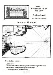
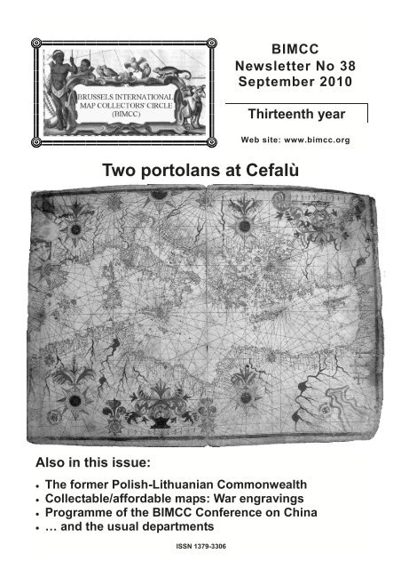
Cover: The Mediterranean, attributed to Placido Caloiro e Oliva, first half 17 th century.<br />
(described as Chart B in the article on page 16) © Fondazione culturale Mandralisca, Cefalù<br />
September 2010 BIMCC Newsletter No 38 3<br />
4<br />
6<br />
8<br />
10<br />
11<br />
16<br />
24<br />
26<br />
28<br />
29<br />
30
PICTURES AT AN EXHIBITION I<br />
Highlights of Polish and European cartography in Warsaw<br />
The opening of the Royal Castle Library in Warsaw<br />
on 14 June 2010 (see Newsletter No 37) was<br />
accompanied by a cartographical exhibition curated<br />
by Dr Kazimierz Kozica, and designed to highlight,<br />
through some of the finest maps and views from the<br />
recently-acquired Niewodniczanski Collection, the<br />
interaction between Polish and European cartography<br />
and topography over the course of history.<br />
Interestingly, there seemed to be two parallel<br />
strands running through the exhibition: the<br />
contribution made to the development of European<br />
4<br />
Antiquariaat SANDERUS<br />
F. Devroe<br />
Old maps, atlases and prints<br />
Nederkouter 32<br />
9000 Gent<br />
Tel +32(0)9 223 35 90<br />
Fax +32(0)9 223 39 71<br />
www.sanderusmaps.com<br />
E-mail: sanderus@sanderusmaps.com<br />
cartography by Polish cartographers, and conversely,<br />
the contribution made to the development of Polish<br />
cartography by foreigners, usually but not always in<br />
the service of some of Poland's more cartographicallyminded<br />
monarchs.<br />
The earliest map on display was the first modern<br />
Tabula Moderna to stretch across the whole of<br />
Central and Eastern Europe and encompass,<br />
according to the title, Polonie Ungarie Boemie<br />
Germanie Rvssie Lithvanie. Published in Rome by<br />
Marco Beneventano in 1507, it was drawn in<br />
cooperation with Bernard Wapowski, the father of<br />
Polish cartography, and is the first map to mention<br />
Poland in the title. Waclaw Grodecki's Poloniae<br />
Litvaniaeq. Descriptio, the later state is shown here,<br />
had enormous influence on Western cartography,<br />
mainly on account of its inclusion by Abraham Ortelius<br />
in his atlases as from 1570. In the same year another<br />
notable product of Renaissance cartography in<br />
Poland was published in Venice, Andrzej Pograbka's<br />
Partis Sarmatiae Europeae, of which only a few<br />
copies are known. Tomasz Makowski's Magni<br />
Ducatus Lithvaniae, first published by Willem Blaeu in<br />
Amsterdam in 1613 – the state on display here dates<br />
from 1631 – is a landmark representation of the lands<br />
comprised in the eastern half of the Polish-Lithuanian<br />
Commonwealth.<br />
Paulus Swaen<br />
Internet <strong>Map</strong> Auctions<br />
March-May-September-November<br />
<strong>Map</strong>s, Globes, Views, Atlases,<br />
Prints<br />
Catalogue on: www.swaen.com<br />
E-mail: paulus@swaen.com<br />
Tel. +1 727 687 32 98<br />
BIMCC Newsletter No 38 September 2010
The skills of non-Polish<br />
cartographers were also much<br />
in evidence in the exhibition.<br />
In 1593 Gerard de Jode<br />
inserted a profile portrait of<br />
King Sigismund III Vasa in his<br />
Poloniae amplissimi regnii,<br />
published in Antwerp. In 1658<br />
Antonius Gudicanus drew his<br />
Nova Descriptio Totius Regni<br />
Polonici in the form of an<br />
eagle, the country's national<br />
symbol, an image which is<br />
perhaps Poland's answer to<br />
the Leo Belgicus. And half a<br />
century later the Amsterdam<br />
publisher Chatelain included<br />
in his own atlas a Carte de<br />
Pologne attributed to Nicolas<br />
Gueudeville, showing regional<br />
coats of arms and setting forth<br />
a chronology of the country's<br />
monarchs. The splendours of<br />
the Amsterdam, Nuremberg<br />
and Paris publishers were not<br />
overlooked: Carel Allard, Jakob Sandrart, Guillaume<br />
Sanson and Hubert Jaillot, all produced highly<br />
decorative images of the country at its greatest extent,<br />
if not at the height of its fortunes, in the 17 th century.<br />
France's notable contribution to Polish and<br />
European cartography was evidenced above all by<br />
the first scientifically-measured map of Ukraine,<br />
Delineatio Generalis Camporum Desertorum vulgo<br />
Ukraina, drawn by Guillaume Vasseur de Beauplan,<br />
an army engineer from Rouen who had entered the<br />
service of King Wladyslaw IV Vasa. First published by<br />
Wilhelm Hondius in Gdansk in 1648, this map<br />
subsequently reappeared in modified form in many of<br />
the best-known 17 th century atlases and consequently<br />
exerted enormous influence on the image of this part<br />
of Europe in Western cartography. A century later, in<br />
1753, Johann Friedrich Endersch, mathematician to<br />
the Saxon court, drew an accurate image of the<br />
mouth of the Vistula in his <strong>Map</strong>pa Geographica Trivm<br />
Insularum in Prussia.<br />
Not long after his election in 1763, the enlightened<br />
Stanislas August Poniatowski, last King of Poland,<br />
succeeded in attracting several prominent French and<br />
Italian artists and cartographers to his court. In 1770<br />
the Venetian Bartolomeo Folino engraved a large<br />
scale Carte Generale et Nouvelle de toutte la<br />
Pologne, noteworthy in that it shows the country's<br />
roads. This was followed two years later by Giovanni<br />
Rizzi-Zannoni's Carte de la Pologne, an atlas of<br />
Poland - assembled here into a magnificent wall map<br />
- which constitutes the first modern representation of<br />
the country. The maps of Poland's central regions and<br />
of the area around Warsaw by the royal cartographer<br />
Charles De Perthees, based on accurate surveys and<br />
published in Paris after 1792, are outstanding in terms<br />
of accuracy of detail.<br />
Paramount amongst the series of views of Polish<br />
towns and cities by Georg Braun and Frans<br />
Hogenberg is their spectacular Cracovia minoris<br />
Poloniae Metropolis 1617, from their magnum opus<br />
Civitates Orbis Terrarum, the earliest townbook.<br />
Combining cartography and city views or plans,<br />
Jodocus Hondius' Nova Poloniae delineatio ca. 1620<br />
(pictured above) and John Speed's Newe <strong>Map</strong>e of<br />
Poland 1626, incorporate additional visual information<br />
within their borders, in the form of vignettes of major<br />
cities, particularly Cracow, Gdansk and Wroclaw, and<br />
of figures in local costume. Almost a century and a<br />
half later, in the last years of the Wettin dynasty from<br />
Dresden in Saxony, Pierre Ricaud de Tirregaille drew<br />
his monumental Plan de la Ville de Varsovie 1762,<br />
which reflected the city's layout adorned by the most<br />
prominent buildings. But pride of place in this sphere<br />
is surely held by Antonio Canaletto's cousin, Bernardo<br />
Bellotto, court artist of Stanislas August Poniatowski,<br />
whose three magisterial engravings from 1771, 1772<br />
and 1774 depict pre-partition Warsaw in its twilight<br />
years as capital of the Polish-Lithuanian<br />
Commonwealth. Although not part of this exhibition,<br />
Bellotto's series of views of Warsaw painted in oil for<br />
the Royal Castle were considered accurate enough to<br />
serve in the reconstruction of the capital after its total<br />
destruction in 1945.<br />
Peter Galezowski<br />
galezpe@hotmail.com<br />
September 2010 BIMCC Newsletter No 38 5
PICTURES AT AN EXHIBITION II<br />
La Mer à l'Encre – Trois siècles de cartes marines – XVI e – XVIII e siècles<br />
(The sea in ink – Three centuries of sea charts – 16 th-18 th centuries)<br />
Corderie Royale – Rochefort-sur-mer, until 31 December 2011<br />
The exhibition, on display until<br />
31 December 2011 in Rochefort<br />
(Charente Maritime, France) in the<br />
showrooms of the Royal Rope<br />
Factory 1 , was conceived and<br />
realised in collaboration with the<br />
Department of Defence history of<br />
Vincennes and its local branch of<br />
Rochefort.<br />
The exhibition focuses on three<br />
areas:<br />
• A p r e s e n t a t i o n o f t h e<br />
cartographic production in<br />
Normandy during the 16 th and<br />
17 th centuries;<br />
• A presentation dedicated<br />
entirely to the Neptune François<br />
(published in 1693), the general<br />
cartographic work completed on<br />
the initiative of Colbert, minister<br />
of Louis XIV;<br />
• Finally, through filmed theatre<br />
and projected video, the visitor<br />
is invited to attend a debate between a<br />
cartographer of the 18 th century engaged in<br />
calculations without end, and a captain focused on<br />
the avoidance of very real obstacles.<br />
Only the first two areas are reported here.<br />
The exhibition presents a rich iconography mostly<br />
provided by the Bibliothèque Nationale de France and<br />
the Naval department of the Service Historique de la<br />
Défense of Vincennes together with ancient<br />
navigational instruments.<br />
Cartographic production since the Middle Ages<br />
Before ‘Norman’ mapping, the exhibition presents:<br />
• The so-called ‘Pisan’ map, the oldest known<br />
western chart representing full details of the<br />
Mediterranean and more roughly the Atlantic coast<br />
and the Channel, probably drawn around 1290 in<br />
Genoa;<br />
• The Portolan Chart certainly executed in Palma de<br />
Mallorca in 1339 and signed by Angelino Dulcert,<br />
the first known Catalan map. This manuscript map<br />
on parchment includes a rich nomenclature of the<br />
hinterland together with the representation of<br />
mountain ranges, rivers and lakes, even Mansa<br />
Musa, emperor of Mali, appears;<br />
• The Travels or Book of Marvels (1410) of Jean de<br />
Mandeville.<br />
1 For practical details, see page 36<br />
6<br />
Other sumptuous images are also<br />
presented, such as:<br />
• An excerpt from the Catalan<br />
Atlas describing the Far East by<br />
A braham Cr esques, 1 3 75<br />
(reported in 1380 as being from<br />
the library of Charles V, king of<br />
France);<br />
• The ‘Planisphere’ or ‘Cantino<br />
World <strong>Map</strong>’ of Alberto Cantino<br />
(about 1502) that marks the end of<br />
the medieval era and represents<br />
the divide of the world between<br />
Spain and Portugal as a result of<br />
the Treaty of Tordesillas of 1494;<br />
• The <strong>Map</strong> of Atlantic from the<br />
Miller Atlas of Lopo Homem, 1519.<br />
The so-called Norman maps<br />
appeared later and their production<br />
is linked to economic development<br />
in Normandy. Norman mapping<br />
developed around the port of<br />
Dieppe under the leadership of major ship-owners<br />
from Dieppe, like Jean Ango (1480-1551). The Dieppe<br />
school is particularly active between 1540 and 1634,<br />
its golden age being between 1540 and 1580. This<br />
school is in fact the city school of hydrography where<br />
the art of navigation was taught. The school was<br />
mainly led by the priest Pierre Desceliers (1487-1553)<br />
and cartographers, from Nicolas Desliens to Jacques<br />
de Vau de Claye including Jean Rotz, Nicolas Vallard,<br />
Pierre Descelliers, Guillaume Le Testu and Jean<br />
Cosson. The reputation of Norman cartography<br />
continues until the 17 th century thanks to the pilots<br />
Pierre de Vaulx and Jean Guérard.<br />
The Universal Cosmography of 1556 by Guillaume<br />
Le Testu is an example of the persistence of a<br />
phantasmagorical representation of the world in<br />
opposition to an increasingly concrete awareness of<br />
the actual world.<br />
More modest, the Conquet School shines in<br />
Britanny through Guillaume Brouscou who in 1548<br />
published the Manual of navigation for the use of<br />
Breton sailors.<br />
The exhibition also addresses the complexity of<br />
the maps and their impact on the art of navigation at<br />
sea, with excerpts from the Diary of Francis Drake, as<br />
well as on the art of sailing close to the coast, with<br />
excerpts from the Great rudder of the sea by Pierre<br />
Garcie called Ferrande, Venetian coastal trade<br />
master, which was reprinted 25 times between 1518<br />
and 1643.<br />
From the 16 th to the 17 th century, the Netherlands<br />
BIMCC Newsletter No 38 September 2010
dominated the world of cartography, Amsterdam<br />
taking over from Antwerp. The first land or sea atlases<br />
came from the Netherlands and their production<br />
occupied several publishers such as Hondius and<br />
Blaeu. The marine atlas of Johannes Janssonius<br />
(1588-1664) published in 1650 in the fifth part of his<br />
Atlas novus is displayed in the exhibition together with<br />
a copy of the famous 1587's ‘Mirror of the sea’<br />
(Spieghel der Zeevaerdt) of Lucas Janszoon<br />
Waghenaer. After this publication, the name of<br />
‘Waggoners’ was given for some time to sea atlases.<br />
Alongside commercial map production, the VOC<br />
(Verenigde Oost-Indische Compagnie - United Dutch<br />
East India Company) had its own cartographers since<br />
1612. Their task was to provide navigators with the<br />
necessary manuscript charts and to use the<br />
information collected by navigators. From 1633 to<br />
1705, the Blaeus were the chart makers of the VOC.<br />
The French Neptune<br />
Despite the magnificent achievements of<br />
Normandy, France remained a minor player in<br />
European cartographic production until the second<br />
half of the 17 th century. The Navy plays a vital role in<br />
the protective system of Colbert who no longer wants<br />
to depend on foreign countries for the construction of<br />
vessels, crewing or chart making. This led to the<br />
creation of the Paris Observatory (founded in 1667)<br />
and the Academy of Sciences which publishes since<br />
1679 the Knowledge of Time designed to provide<br />
sailors with tables giving the precise position of the<br />
main stars in the sky. Quite naturally, Colbert will call<br />
upon Louis-Nicolas de Clerville (1610-1677),<br />
Commissioner General of Fortifications, to map the<br />
coasts of the ocean from Dunkerque to Bayonne. The<br />
work thus produced is the first real attempt to<br />
represent the coastline to a satisfactory scale and<br />
according to surveys carried out in the field. But they<br />
are too faulty and limited in scope with the result that<br />
the Clerville mapping is too vague.<br />
In 1671, the Chevalier de Clerville is replaced by a<br />
military engineer, La Favolière. To avoid inaccurate<br />
maps causing shipwrecks, La Favolière gives a key<br />
role to the seamarks, the bathymetry and the<br />
systematic representation of banks and shoals:<br />
charting finally enters the age of hydrography. The<br />
work is emblematic of La Favolière’s contribution and<br />
the novelty to what became in 1693 the Neptune<br />
François. The book comprises 29 maps showing the<br />
European coasts from Norway to Gibraltar.<br />
Counterfeited and imitated abroad (even at the<br />
time of its publication in France by Pieter Mortier, the<br />
Dutch bookseller in Amsterdam), the Neptune<br />
François is not very well received in France where<br />
sailors are confused by the most innovative features,<br />
including the Mercator projection. It will be forgotten<br />
for several decades and the copper plates will be<br />
purchased by the French Department of the Navy in<br />
1751 and filed in the Dépot des Cartes et Plans of the<br />
Navy, founded in 1720. A second edition of the<br />
Neptune François is published in 1753 using the<br />
original copper plates supplemented and corrected on<br />
some points by Jacques-Nicolas Bellin, official<br />
hydrographer of the Navy. A third edition appeared in<br />
1773 and a final edition published in 1806 by the<br />
Imperial Printing press. The Neptune François will be<br />
supplanted in the early 19 th century by the French<br />
Pilot of Beautemps-Beaupré.<br />
The exhibition features a copy of the ‘Neptune<br />
François’ (which, fortunately, did not suffer from the<br />
flood following the storm Xynthia on 28 February<br />
2010) and an ‘electronic’ version which you can<br />
browse pages and admire the magnificent images of<br />
the French coastline.<br />
As an extension to the exhibition of the Royal<br />
Rope Factory, the National Naval Museum of<br />
Rochefort presents the exhibition ‘Tracez la route ! –<br />
Cartes et marins, hier et demain’ (Draw your route.<br />
Charts and sailors, yesterday and to-morrow). It is a<br />
journey through time from world maps, coastal and<br />
seabed charts, including among other things, an<br />
interactive area, allowing visitors to try a 3D<br />
simulation software on learning how to get a boat<br />
licence.<br />
Claude Leclerc<br />
leclerc.claude@orange.fr<br />
References:<br />
• La mer à l'encre, trois siècles de cartes marines du<br />
Moyen Age au siècle des Lumières (exhibition<br />
catalogue)<br />
• Les cahiers de la Corderie / au large © Corderie<br />
Royale – Centre <strong>International</strong> de la Mer, 2010<br />
Part of the coast of Brittany<br />
From Jacques Nicolas Bellin’s 1773 edition of<br />
Le Neptune François<br />
September 2010 BIMCC Newsletter No 38 7
LOOKS AT BOOKS I<br />
De Ptolémée à La Guillotière (XV e - XVI e siècle) – Des cartes<br />
pour la France, pourquoi, comment?<br />
(From Ptolemy to La Guillotière (15 th - 15 th century) – <strong>Map</strong>s for<br />
France, why and how?)<br />
by Monique Pelletier<br />
Comité des Travaux historiques et scientifiques (CTHS, Committee of historical and cartographic works), Paris, 2009, 192 pp., 62 b/w and<br />
19 colour ill., 9 maps on CD-ROM; soft cover, 21 x 27 cm. ISBN 978- 2-7355-0687-3, EUR 39<br />
To order: CTHS, 110 rue de Grenelle, F-75357, Paris, cédex 07, www.cths.fr<br />
Monique Pelletier is well<br />
known to our readers, not only<br />
for her many reference books<br />
on the history of French<br />
cartography, but also because<br />
she has honoured the BIMCC<br />
by speaking at our Conference<br />
in 2002 and by writing several<br />
articles for our publications.<br />
While she had previously<br />
devoted particular attention to<br />
the first ‘scientific’ map of<br />
France developed over four<br />
generations by the Cassini<br />
dynasty 1 , in this new book, she<br />
focuses on early maps of<br />
France and, particularly, on the<br />
Charte de la France by<br />
François de La Guillotière first<br />
published in 1615.<br />
Before analysing in depth<br />
this map and its author (in<br />
Chapter 5), the book presents a complete inventory<br />
of the pre-existing French cartographic world.<br />
Chapter 1 begins with the Ptolemaic<br />
representations of Gallia and Francia, and continues<br />
with the new map, Nova totius Galliae descriptio,<br />
produced by Oronce Fine and first printed in 1525.<br />
The revised version of this description made by Jean<br />
Jolivet and published in 1560 was reproduced in the<br />
map gallery of the Vatican and later copied by<br />
Ortelius in the first edition of his Theatrum (1570).<br />
Chapter. 2 presents the first regional maps of<br />
certain French provinces which were probably used<br />
as sources by La Guillotière: Le Mans’ diocese by<br />
Macé Ogier (1539), Normandy and Berry by Jean<br />
Jolivet (1545), Bourbonnais by Nicolas de Nicolay<br />
(1569).<br />
Chapter 3 deals with close-up visions of the<br />
territory such as perspective views of cities or<br />
‘portraits’ of landscapes produced by surveyors or by<br />
painters.<br />
Chapter 4 analyses the diffusion of provincial<br />
maps and city plans through the editorial circuits. In<br />
the second half of the 16 th century, several French<br />
provinces were mapped by amateur cartographers,<br />
who had another profession (priest, lawyer, doctor…)<br />
1 See Newsletter No 15 for a review of her work.<br />
8<br />
but were sufficiently interested<br />
in science to apply some form<br />
of triangulation to survey their<br />
r egion with r e ason able<br />
accuracy. These maps of local<br />
interest served as sources for<br />
the publication of wider maps<br />
and were traded between<br />
cartographers. In particular,<br />
there were important exchanges<br />
between France and Flanders<br />
w h i c h d o m i n a t e d t h e<br />
cartographic market of the time.<br />
Ortelius, for example, acquired<br />
m a ps f r om O g i e r a n d<br />
Bouguereau, while, later on,<br />
some of the maps from Ortelius<br />
were copied back into Le<br />
T h é a t r e F r a n ç o y s o f<br />
Bouguereau! Similarly city<br />
plans seemed to have been<br />
exchanged extensively between<br />
the Cosmographie Universelle of François de<br />
Belleforest (1575) and the Civitates Orbis Terrarum of<br />
Frans Hogenberg (from 1572).<br />
Finally, in Chapter 5, Monique Pelletier presents in<br />
detail the work of La Guillotière. His map of France<br />
comprises nine sheets which, when assembled,<br />
constitute a map of 104 x 147 cm, the largest<br />
produced in the 16 th century. Its scale is about<br />
1: 925 000, i.e. double that of previous maps of<br />
France by Jolivet (1: 2 300 000) or by Fine<br />
(1: 1 750 000). The maps were engraved on wood<br />
around 1580 by François Desprez, who also financed<br />
the work; toponyms were written with metal plates<br />
molded from typographical characters and inserted<br />
into the wooden plates. The quality of the resulting<br />
work tends to prove that wood cuts can be as nice as<br />
copper engravings!<br />
Chapter. 5 also discusses the biography of La<br />
Guillotière, who, after working some 25 years on his<br />
map of France, died in poverty in 1595, according to<br />
his newly discovered will. In 1615, 20 years after its<br />
author's death and more than 30 years after it had<br />
been engraved, the map was published by Jean IV<br />
Leclerc who obviously wanted to be taken for the real<br />
author...<br />
The map was dedicated to the young Louis XIII<br />
who, by then, had succeeded king Henri IV. It<br />
BIMCC Newsletter No 38 September 2010
depicted not only French territory enlarged through<br />
the reign of ‘Henri le Grand’, but extended far to the<br />
east well into Germany and northern Italy; this was<br />
justified by reference to the ancient notion of Gaul<br />
which was much larger than France.<br />
In this chapter, Monique Pelletier analyses all the<br />
aspects of the Charte: accuracy, contents,<br />
presentation and décor, successive editions and<br />
sources used.<br />
The accuracy of latitudes is compared to that of<br />
contemporary maps of France: it is better than Jolivet,<br />
but not as good as Fine. The accuracy is also<br />
assessed by comparing distances between city pairs<br />
with a modern map; the errors range from –13% to<br />
+11% within France proper. Errors tend to be larger in<br />
northern Spain, in Italy and in Germany.<br />
These variations in accuracy are probably due to<br />
the variety of sources used and the method employed<br />
to combine them. La Guillotière did not start from a<br />
pre-existing map of France (such as Jolivet’s) but<br />
compiled the provincial maps available, including<br />
some of his own making (e.g. Normandy), as well as<br />
maps of neighbouring countries to cover the eastern<br />
part of his Charte. La Guillotière did not just copy and<br />
assemble these sources; he drew his map based on<br />
the canvas constituted by the coast lines and the<br />
hydrological network, and he positioned the various<br />
localities with respect to this network.<br />
Detail showing, on top of Zeeland,<br />
the arms of the kingdoms of France and Navarra<br />
The book is very well documented and the<br />
numerous bibliographical references reflect the vast<br />
historical and cartographic culture of the author. An<br />
index and a rich bibliography (8 pages) complement it.<br />
There is also a CD-ROM inserted in the book<br />
cover. It contains ten pictures (in jpeg format, with 8 to<br />
10 Mb each): the nine sheets and the assembled<br />
map. This allows one to zoom in on the details of any<br />
map and to print a subset of one’s favourite area.<br />
Detail of the north-west sheet of the Charte de la France’<br />
(Bibliothèque nationale de France, Cartes et Plans, Ge C 22 500)<br />
Jean-Louis Renteux<br />
editor@bimcc.org<br />
September 2010 BIMCC Newsletter No 38 9
LOOKS AT BOOKS II<br />
The Island of Lost <strong>Map</strong>s: A True Story of Cartographic Crime<br />
by Miles Harvey<br />
Phoenix paperback, London, 2002 (first published 2001), 405 pp., 15 b/w ill., soft cover, 13 x 20 cm. ISBN 0 75381-315-7, GBP 7.99<br />
This book looks, and reads,<br />
like a novel. Yet it is not fiction<br />
and its subject-matter is quite<br />
serious.<br />
It centres on the story of<br />
Gilbert Bland (also known under<br />
many other names) who became<br />
famous – or rather infamous – in<br />
1995, as the ‘greatest American<br />
map thief in history’. He stole<br />
hundreds of maps from a number<br />
of reputed libraries across the US<br />
and British Columbia, with<br />
incredible ease; he just slashed<br />
pages out of books and atlases<br />
with a razor blade… until<br />
someone caught him in the act at<br />
the Peabody Library in Baltimore<br />
on 7 December 1995. He was<br />
arrested… and released after<br />
giving 700 $ in cash to the Library<br />
to compensate for the damage<br />
inflicted on four books, a petty<br />
crime in the eyes of the Baltimore police! However, a<br />
notebook he left behind revealed that Bland was not<br />
just an occasional map thief, but that he was<br />
systematically visiting major libraries with a shopping<br />
list of ancient maps for which he had identified<br />
potential buyers. This triggered a warning to be<br />
issued to all libraries concerned, through the Ex Libris<br />
Internet discussion group. The FBI got involved but<br />
only managed to arrest Bland on 2 January 1996,<br />
leaving him enough time to remove his stock from his<br />
Antique <strong>Map</strong>s shop near Fort Lauderdale, Florida.<br />
This allowed Bland to negotiate a plea bargain for<br />
a reduced sentence (he spent less than 17 months in<br />
prison for his cartographic crimes), against the<br />
restitution of stolen maps. His cache contained some<br />
10<br />
150 antique maps, and 100 more<br />
were retr ieved from his<br />
customers; the total was then<br />
worth about half a million US<br />
dollars. Strangely enough, the<br />
FBI had a difficult time returning<br />
these maps to their legal owners;<br />
after two years (long after Bland<br />
had been released from jail), only<br />
180 maps out of 250 had been<br />
returned; many libraries were<br />
unaware that maps had been cut<br />
out of their books or atlases, or<br />
they would not admit that their<br />
security system could be<br />
deficient… The positive side of<br />
this deplorable story is that<br />
security has now been reinforced<br />
in libraries around the world.*<br />
Author Miles Harvey spent four<br />
years investigating this case,<br />
trying to understand Gilbert<br />
Bland’s motivations, and he<br />
provides lots of background information on his past.<br />
The episodes of this cartographic crime spree are<br />
also interleaved with chapters exploring various<br />
aspects of the world of maps: history of cartography<br />
and exploration, libraries and librarians, map<br />
collectors, map dealers and map auctions, etc. Some<br />
philosophical and literary digressions are not really<br />
indispensable, but, overall, this book is a good read<br />
and also a lively introduction to the universe of map<br />
collecting.<br />
Jean-Louis Renteux<br />
editor@bimcc.org<br />
* According to <strong>Map</strong>Hist (http://mailman.geo.uu.nl/pipermail/maphist/2008-January/011131.html), Gilbert Bland might have<br />
been active again in the map business in 2008…<br />
BIMCC Newsletter No 38 September 2010
HISTORY AND CARTOGRAPHY<br />
The former Polish-Lithuanian Commonwealth<br />
as depicted in albums and atlases<br />
by Dr Lucyna Szaniawska<br />
(translated and edited by Peter Galezowski)<br />
A decade or so after the break-up of the Soviet Union, a number of works on the history of cartography<br />
were published in the lands of the former Polish-Lithuanian Commonwealth, now four independent<br />
States – Belarus, Lithuania, Poland and Ukraine. Three works were published by state institutions<br />
– in Lithuania by the National Museum with funding from the Ministry of Culture, in Poland by<br />
the Główny Urząd Geodezji i Kartografii (Head Office for Land Surveying and Cartography) and in<br />
Ukraine by the State Scientific Institute (DNVP) ‘Kartografia’. The Belarussian work, on the other<br />
hand, was privately printed and is not the result of a collective effort in contrast to the other three,<br />
whose co-authors are named on the editorial pages.<br />
It is clear from the selection of cartographical materials, method of presentation and contents, that<br />
the authors and publishers of these works were pursuing somewhat differing aims which are reflected<br />
in the nature of the works themselves, published as albums or atlases. The four works are<br />
considered below by date of publication.<br />
Lithuania on the <strong>Map</strong>. Aldona Bieliūniené, Biruté<br />
Kulnyté and Rūta Subatniekiené, Vilnius: National<br />
Museum of Lithuania, 2002.<br />
This 218-page album, published in an English as<br />
well as a Lithuanian version, is<br />
preceded by an essay on the<br />
development of the Lithuanian<br />
state and on the history of<br />
cartography in Lithuania and<br />
neighbouring countries. The<br />
description of the history of<br />
Lithuanian cartography opens<br />
with the map by Claudius<br />
Ptolemeus and brings the story<br />
right up to the present with, for<br />
instance, a map from 2001<br />
depicting Lithuanian emigration<br />
overseas and deportation of<br />
Lithuanians to the Soviet Union<br />
between 1940 and 1988. The<br />
dramatic history of the struggling<br />
19 th Lithuanian state is balanced<br />
by a discussion of the achievements of Joachim<br />
Lelewel, Professor of history at Vilnius (then Wilno)<br />
University who was particularly active in the fields of<br />
cartography, history, archaeology and numismatics.<br />
He was also a passionate collector who bequeathed<br />
his collections, invaluable for the cultures of Central<br />
Europe, to Vilnius University 2 .The authors of this<br />
album availed themselves of Lelewel’s celebrated<br />
collection of almost 400 early atlases and individual<br />
maps, as well as of other collections such as that of<br />
the Vilnius University Library, the Library of the<br />
Lithuanian Academy of Sciences, the National<br />
Museum of Lithuania and the Lithuanian State<br />
Archives.<br />
The core of the publication is<br />
essentially a catalogue entitled<br />
LITHUANIA in the Cartography of<br />
the 15 th – 20 th Century. The<br />
illustrations are presented in<br />
chronological order, starting with<br />
Ptolemy's OCTAVA EUROPAE<br />
TABVLA published in Rome in<br />
1490. The plates consist mainly<br />
of map reproductions and<br />
a c c o m p a n y i n g h i s t o r i c a l<br />
documents, for instance the title<br />
page of La cosmographie<br />
universelle by Sebastian Münster<br />
published in Basel in 1556,<br />
p o r t r a i t s o f w e l l - k n o w n<br />
cartographers such as Gerard<br />
Mercator engraved by Franz Hogenberg in 1574,and<br />
town plans and views such as the manuscript plan of<br />
Vilnius entitled Tabula ichonographica... Anno 1648<br />
drawn by Frederick Getkant (1600–1668), a military<br />
engineer and cartographer in the service of King<br />
Wladyslaw IV Vasa. There are also battle scenes, for<br />
instance the Conflictus inter SVECOS et LITHVANOS<br />
dimidio ab Urbe Sandomiria... from De rebus a Carolo<br />
Gustavo Sueciae Rege gestis... by the historian<br />
1 These states were all formerly part of the so-called Republic of Two Nations or pre-partition Poland-Lithuania, a state which at its greatest<br />
extent stretched from the Baltic to the Black Sea; it came formally into being as a result of the Union of Lublin 1569 and was dismembered<br />
by its more powerful neighbours, Prussia, Russia and Austria, in three successive partitions, 1772, 1793 and 1795, disappearing<br />
from the map altogether for over a century (Translator’s note).<br />
² After the failed 1830-1831 uprising, he emigrated to Belgium and died in <strong>Brussels</strong>; for details of his life and activities see the catalogue of<br />
the exhibition held at the Royal Library in <strong>Brussels</strong> in 1986 on the bicentenary of his birth ‘Joachim Lelewel en Belgique. Commémoration<br />
1786-1986’ (Translator’s note).<br />
September 2010 BIMCC Newsletter No 38 11 11
Samuel Pufendorf, drawn by Erik Dahlbergh and<br />
published in Nuremberg in 1696, and some<br />
photographs depicting for instance officers of the<br />
Army's Topographical Service demarcating the<br />
Lithuanian-Soviet border in 1939. The illustrations are<br />
described and in places accompanied by a brief<br />
historical commentary.<br />
Alternating with each other in chronological order<br />
are maps of Europe, the Polish-Lithuanian<br />
Commonwealth, Russia, the Baltic, Livonia and<br />
Prussia, which together with other historical<br />
documents make up the image of Lithuania. At the<br />
end, there is an annex with an index of persons,<br />
bibliographies and English translations of Latin texts<br />
accompanying the maps (Fig.1), for instance the<br />
description LITHVANIA DVCATVS. Samogitia, Russia<br />
& Volhinia printed on the verso of the map of<br />
Lithuania in 17 th century editions of Mercator's atlas.<br />
Ukraina na starodavnih kartah.<br />
Kinec’ XV – perša polovina XVII st.<br />
(Ukraine on old maps – from the<br />
end of the 15 th to the first half of the<br />
17 th century). M. Vavričin, Â.<br />
Daškevič and U. Krištalovič. Kiev:<br />
State Scientific Institute (DNVP)<br />
‘Kartografiâ’, 2004<br />
This album, which contains 207<br />
pages and is in Ukrainian and English,<br />
is authored by three historical<br />
cartographers from Lviv in Ukraine,<br />
and is preceded by an introduction by<br />
Rostyslav Sossa in which the<br />
U k r a i n i a n t r a d i t i o n o f m a p<br />
reproduction is described together<br />
with a brief account of the<br />
cartographical holdings of two Lviv scientific<br />
institutions (the Vasyl Stefanyk Library and the Ivan<br />
Franko Library). The purpose of the work is also set<br />
out. 3<br />
In contrast to the Lithuanian album, the Ukrainian<br />
one merely describes and reproduces maps and is<br />
concerned entirely with the history of cartography.<br />
The chronological span is shorter, and embraces two<br />
centuries, from the end of the 15 th to the middle of the<br />
17 th century. As in the Lithuanian album, each plate is<br />
a map, described in full. There is a technical section<br />
setting forth the name of the author, publisher and<br />
engraver, the title of the work from which the map is<br />
taken, printing technique, dimensions and the<br />
language of the map. An accompanying text specifies<br />
the map’s contents and extent, setting out the names<br />
of mountains, rivers and other features in areas lying<br />
within present-day Ukraine. Finally, the cartographical<br />
sources used by the map’s author and its later<br />
derivatives are given. The chronological order is<br />
strictly observed, as in printed catalogues. The maps<br />
12<br />
Fig. 1 Note on the Polesian marshes from Tomasz Makowski’s<br />
Magni Ducatus Lithuaniae 1613.<br />
themselves depict widely differing<br />
areas: the World, Europe, the Polish-<br />
Lithuanian Commonwealth, Russia,<br />
Lithuania, Hungary, Transylvania, but<br />
also Asia and Turkey. They are<br />
reduced in size by differing degrees,<br />
conveying the impression of a<br />
somewhat disorderly ensemble at<br />
odds with an atlas-type publication.<br />
Another feature which distinguishes<br />
this album from the other publications<br />
reviewed here is that, putatively<br />
directed at a mainly Ukrainian<br />
readership, it shows, alongside<br />
reproductions of the whole map,<br />
enlarged fragments of Ukrainian lands<br />
(Fig. 2)<br />
Fig. 2 Ukrainian regions on Gerard Mercator’s Hungaria<br />
Regnum in Willem Blaeu’s 1643 version.<br />
3 This work has recently been supplemented by a second volume, bearing the same title, published by the same team in 2009 and covering<br />
the period from the mid-17 th to the second half of the 18 th century (Translator’s note).<br />
BIMCC Newsletter No 38 September 2010
S t a r a ž y t n a j a k a r t a g r a f i j a<br />
Bielaru si ( Belaru s in old<br />
cartography). Lev R. Kozlov, Minsk:<br />
‘Arty-Feks’, 2005<br />
This 46-page atlas, which<br />
comprises maps published between<br />
1570 and 1821 and is in Belarussian,<br />
is described as an album by the<br />
author, a historian who has for many<br />
years been dealing with the history of<br />
cartography of the Belarussian lands.<br />
In his introduction, entitled Lectori<br />
salutem, which suggests that the work<br />
is intended to be as reader-friendly as<br />
possible, the author encourages<br />
readers to learn about „the lands in<br />
which their ancestors lived”. And the<br />
reproductions have been prepared in<br />
such a way as to make the maps highly readable. The<br />
author did not attempt to produce a coloured album<br />
which appeals to the eye, but selected black and<br />
white maps in which the contents and names have not<br />
been obscured by colours. The atlas can thus usefully<br />
serve as a sourcebook.<br />
As in the Ukrainian album, only reproductions of<br />
original maps are used as illustrations, although the<br />
underlying conception is different. All the maps are<br />
published on a scale of 1:1 or almost, and shown in<br />
Polonia. Atlas map z XVI –<br />
XVIII wieku. (Polonia. An atlas of<br />
maps from the !6 th to the 18 th<br />
century).<br />
Introduction by Professor<br />
Stanislaw Alexandrowicz. Warsaw:<br />
Główny Urząd Geodezji i<br />
Kartografii, 2005<br />
This atlas opens with an<br />
introduction in Polish to the<br />
country’s cartographical heritage<br />
from the 16 th to the 18 th century by<br />
P r o f e s s o r S t a n i s l a w<br />
Alexandrowicz 4 .<br />
The author starts from the<br />
premise that Amsterdam, Augsburg and Nuremberg<br />
publishers would have been unable to issue maps of<br />
the Polish lands unless measurements had previously<br />
been taken and maps previously been drawn to the<br />
appropriate standard in the Polish-Lithuanian<br />
Commonwealth. Polish maps compiled in the first half<br />
of the 16 th century and published before 1650<br />
frequently played a decisive role in the gradual design<br />
by the great West European cartographers, and<br />
primarily by Gerard Mercator, of the correct image of<br />
a substantial part of Europe.” He then proceeds to<br />
discuss selected maps showing Polish lands, starting<br />
with medieval mappae mundi such as Fra Mauro’s of<br />
1459, through various Tabulae novae, Bernard<br />
Wapowski’s maps of Central Europe from 1526 and<br />
chronological and geographical order.<br />
They are grouped into three periods,<br />
the 16 th /17 th ,18 th and 19 th centuries.<br />
Each group opens with a general map<br />
o f t h e P o l i s h - L i t h u a n i a n<br />
Commonwealth, or a fragment<br />
thereof: the first, with Wacław<br />
Grodecki’s representation, as updated<br />
by Andrzej Pograbka in 1570; the<br />
second, with Frederick de Wit’s<br />
Polonia from ca. 1706, the year of his<br />
death and the one by Henry Abraham<br />
Chatelain (1684–1743), published in<br />
his historical atlas in 1720; and the<br />
third, with the map by William Faden<br />
(1750–1836), published by James<br />
Wyld jr. (1812–1887) in 1841. They<br />
are followed by maps of the Grand<br />
Duchy of Lithuania, and subsequently by detailed<br />
maps of individual voivodships (Nowogródek, Połock,<br />
Wilno and Mińsk) by Nicolas Sanson d’Abbeville<br />
(1600–1667) or of individual provinces (’guberniya’)<br />
(Wilno, Witebsk, Grodno, Mohylew and Mińsk),<br />
published by the St. Petersburg Academy of Sciences<br />
in 1820 or 1821. The reproductions are preceded by<br />
short notes on the author and how the map came into<br />
being. The publication closes with a selected literature<br />
and the announcement of a further volume to come.<br />
1528, Stanisław Porębski’s map of<br />
the duchies of Oświęcim and Zator<br />
published in 1570, Jerzy<br />
Freudenhammer’s map of 1645<br />
depicting the Palatinate of Poznan,<br />
and Mikołaj Krzysztof Radziwiłł’s<br />
work on the Grand Duchy of<br />
Lithuania executed between 1569<br />
and 1599, and engraved in<br />
Amsterdam in 1613 from a drawing<br />
by Tomasz Makowski. He also<br />
notes the contributions of foreign<br />
cartographers in the service of<br />
Poland's monarchs, such as the<br />
Frenchman Guillaume Le Vasseur<br />
de Beauplan 5 (- Ed) whose maps first appeared in<br />
Gdansk in 1648 and 1650 and were later published by<br />
Joan Blaeu in 1662, and the work of cartographers<br />
commissioned by Stanisław August Poniatowski, last<br />
king of Poland, and the learned and enlightened<br />
nobleman Aleksander Jabłonowski.<br />
The publication comprises 54 plates, map<br />
reproductions accompanied by explanatory texts. The<br />
maps shown are from the collection of early maps of<br />
the Polish-Lithuanian Commonwealth assembled by<br />
Ewa Woźniak to project an image of the lands which<br />
lie, or once lay, within Poland’s borders, and of<br />
interest to contemporary scholars researching the<br />
history of Poland and of neighbouring countries.<br />
4 one of Poland’s leading specialists in the history of cartography and author of the definitive work on the development of cartography in<br />
the Grand Duchy of Lithuania from the 15 th to the mid-18 th century (Translator’s note).<br />
5 Beauplan was the author of the very first Description d’Ukraine, a landmark work published in Rouen in 1660 (Translator’s note).<br />
September 2010 BIMCC Newsletter No 38 13 13
The arrangement is typical of the 16 th and 17 th<br />
century atlases issued by the foremost Amsterdam<br />
publishers. Accordingly maps of the Commonwealth<br />
are preceded by images of the World and of Europe<br />
by way of introduction to the subject. General maps of<br />
the Commonwealth are followed by maps of its central<br />
regions and then by those of outlying parts,<br />
proceeding from north to south, namely Lithuania,<br />
Prussia, Western Pomerania, Greater Poland, Silesia<br />
and Ukraine. Two maps of the Baltic, which differ<br />
fundamentally from the others in the collection, are<br />
also included at the end. Within each group showing<br />
the same region, the maps are arranged in<br />
14<br />
Fig. 3 Sample page with fragments of maps discussed in<br />
the description.<br />
chronological order according to the date of<br />
publication. The great majority of maps are<br />
reproduced on a scale of 1:1. Only larger maps, such<br />
as the map of the World by Henricus Hondius or<br />
Tomasz Makowski’s map of Lithuania had to be<br />
reduced.<br />
The description of each map comprises its history<br />
and selected features and is compressed into a single<br />
column. The arrangement alongside each other of<br />
maps similar in content and extent was considered<br />
the best method for comparative purposes.<br />
Appropriate fragments were selected and arranged In<br />
columns adjoining the descriptive text for each map<br />
(Fig. 3).<br />
Aside from the commentary, it is possible to<br />
compare a large number of topographical features.<br />
Using a few images, for instance of the bend of the<br />
Vistula on its lower course, in the section between<br />
Torun and Grudziądz, it is possible to establish<br />
incontrovertibly the similarity or otherwise in the<br />
representation of that area. And on that basis, to<br />
contemplate the selection of cartographical materials<br />
and to draw conclusions as to a map's place in<br />
relation to others, and at times as to the authorship of<br />
earlier cartographical works. Between 1595 and 1740<br />
the representation of that particular bend of the river<br />
was very similar on maps of Prussia. From Seutter’s<br />
map of Prussia (Fig. 4), for instance, it appears highly<br />
likely that this image was drawn in the absence of<br />
fresh measurements or fresh surveys on the ground.<br />
In other words, the cartographical representation of<br />
the image was left uncorrected. It is worth noting that<br />
generalisation was a very difficult task for<br />
cartographers, which is no doubt why that same area<br />
was shown differently practically every time on<br />
general maps of the Commonwealth between 1526<br />
and 1772 (Fig. 4). It would seem, however, that it was<br />
no worse, and in the case of Giovanni Rizzi-Zannoni’s<br />
map was even better, than the image depicted on<br />
maps of Prussia from that period.<br />
The publication ends with a bibliography of<br />
reference works citing over 80 titles and with an index<br />
of persons.<br />
The four works discussed above, all published over a brief period, differ considerably from one another. At<br />
first sight, they all comprise maps properly printed in technical terms and can thus be classified as publications<br />
on the history of cartography, although they differ in other respects. The Lithuanian album is a history of the<br />
Lithuanian state told mainly in cartographical images. The authors of the Ukrainian album set themselves as<br />
their main task to retrieve an image of the Ukrainian lands from the most diverse cartographical materials.<br />
Similarly, the Belarussian and Polish atlases show their respective lands in an order of presentation that proceeds<br />
from the general to the particular, although their chronological order differs somewhat. The Ukrainian<br />
album has more maps (119) than the others, although, as in the Lithuanian one, their geographical content<br />
cannot always be fully interpreted, which may hinder scholarly analysis or comparison. The chronological<br />
scope also varies, from very broad in the Lithuanian album to very narrow (two centuries) in the Belarussian<br />
one. Notwithstanding the divergence in the authors’ and editors’ intentions, the readers themselves will probably<br />
reach out for these publications. The reason is quite simple: in all four countries, the history of cartography<br />
aroused in the past very little interest on the part of their own publishers.<br />
BIMCC Newsletter No 38 September 2010
Fig. 4 Comparison of the bend of the Vistula on different maps:<br />
Mmap of the Polish-Lithuanian Commonwealth<br />
by Bernard Wapowski (1526)<br />
<strong>Map</strong> of the Polish-Lithuanian Commonwealth<br />
by Sanson-Rossi (1688)<br />
<strong>Map</strong> of the Polish-Lithuanian Commonwealth<br />
by Giovanni Rizzi-Zannoni (1772)<br />
<strong>Map</strong> of the Polish-Lithuanian Commonwealth<br />
by Grodecki-Pograbka (1598)<br />
<strong>Map</strong> of Prussia by Mathäus Seutter (1740)<br />
PPKW Atlas (2005).<br />
September 2010 BIMCC Newsletter No 38 15 15
HISTORY AND CARTOGRAPHY<br />
A surprise encounter : two portolans at Cefalù,<br />
attributed to Placido Caloiro e Oliva<br />
by Wulf Bodenstein<br />
wulfbo@scarlet.be<br />
In August 2009 my wife and I spent a week in Palermo, the ancient capital of Sicily. I had promised<br />
that, this time, we would concentrate entirely on the historical sites and events, and turn a blind<br />
eye to anything cartographical. As it happened, I did not entirely honour my pledge. Firstly, I could<br />
not resist buying a rather lavishly illustrated book on maps of Sicily spotted in a book store 1 .<br />
Secondly, as we were considering visiting some places nearby, we found mention in our guide 2 of a<br />
Museum in the small town of Cefalù, an hour’s train ride from Palermo, where there were supposed<br />
to be ‘antiques cartes marines’ (ancient sea charts), among the collection of historical artefacts and<br />
old books.<br />
My wife, mustering her best Italian, phoned the Museum, only to be told that the Library was closed<br />
to the public in August, and the curator was absent. We decided to give it a try anyway. The next<br />
day we found our way to the Museo Mandralisca in Cefalù. We separated from the stream of tourists<br />
visiting the rich archeological collections and repeated our request to see the charts in the Library.<br />
Finally, we were shown into the vestibule of the Library upstairs, where Dr Maria Teresa Dispenza,<br />
Administrative Director of the Mandralisca Cultural Foundation, very kindly listened to our request<br />
and, having switched to perfect English, asked us to come back in an hour’s time. What we then discovered<br />
was a big surprise : two portolans of the Mediterranean ! Let me try to shed some light on<br />
these. A closer examination of their cartographic content was facilitated when Dr Dispenza sent me<br />
colour photographs of the two charts and some documentation after our short visit. Prof Corradino<br />
Astengo (Genoa University), a specialist on ancient nautical charts and one of the distinguished<br />
speakers at our 5 th <strong>International</strong> Conference in 2006, Charting the Seas, assisted with bibliographical<br />
support and advice.<br />
The Museum’s Library<br />
The Museo (Fondazione culturale) Mandralisca is<br />
at n° 13, Via Mandralisca, in 90015 Cefalù (PA). Its<br />
public library was established in 1853 with a donation<br />
by Enrico Piraino, Baron of Mandralisca. Among the<br />
6 000 books are some rare volumes of the<br />
16 th century, for example works related to geography<br />
by Olaus Magnus, Giovanni Botero, Philippus<br />
Cluverius, and Ptolemy’s Geografia by Magini. These<br />
two portolans, acquired in the 1930’s, undoubtedly<br />
represent a highlight of this collection: one of the<br />
Aegean Sea, the other of the Mediterranean, both<br />
attributed to Placido Caloiro e Oliva of Messina, first<br />
half of the 17 th century. They were last shown in public<br />
at the 2 nd Exhibition of Ancient Books staged by the<br />
Mandralisca Foundation in Cefalù from 15 to<br />
30 October 1994.<br />
1 Liliane Dufour, Antonio La Gumina, Imago Siciliae, Cartografia storica della Sicilia 1420-1860, Catania : Domenico Sanfilippo Editore,<br />
2007. Cloth-bound in slip case, 32 x 33 cm. 332 pp., 228 maps illustrated in colour, and described. Visit www.dseditore.it. See also my<br />
review of the exhibition of Sicily maps from the La Gumina collection in <strong>Brussels</strong>, L’Isola a tre punte, in BIMCC Newsletter N° 12, January<br />
2002, p. 7.<br />
2 Le Guide du Routard, Sicile, Paris: Hachette, 2009, p. 485<br />
3 See also Helen Wallis, Arthur Robinson (ed.), Cartographical Innovations, An <strong>International</strong> Handbook of <strong>Map</strong>ping Terms to 1900, Tring :<br />
<strong>Map</strong> Collector Publications, 1987, p. 12<br />
16<br />
Portolan Charts<br />
A brief review of definitions, plus a summary of<br />
some of their salient features, is perhaps appropriate<br />
here. Initially, the term ‘portolan’ (from the Italian<br />
portolano) referred to written sailing instructions or<br />
coast pilots (peripli). As of the middle of the<br />
19 th century however, the meaning of this term was<br />
extended, rightly or wrongly, to cover harbour-finding<br />
charts accompanying these sailing instructions, and<br />
‘portolan chart’ became the denomination of a distinct<br />
cartographic genre 3 . This is, generally speaking,<br />
characterized by the following features:<br />
• manuscript, drawn in ink on treated animal skin<br />
(calf or sheep) called ‘vellum’ and often skilfully<br />
embellished with flags, coats of arms, and other<br />
vignettes, at times with heightening in gold;<br />
• although initially destined for navigation along the<br />
coasts of the Mediterranean and the Black Sea,<br />
portolan charts subsequently also covered parts of<br />
BIMCC Newsletter No 38 September 2010
Fig. 1 Typical example of a portolan chart of the Mediterranean, by Banet Panades, Messina, 1557<br />
the Atlantic coasts of Europe and Africa and were<br />
ultimately produced in the form of planispheres,<br />
reflecting the results of European exploration;<br />
• place names are written inland, perpendicular to<br />
the coast ; colouring conventions permit distinctions<br />
between places of varying importance;<br />
• a network of rhumb lines covers the chart to permit<br />
plotting a route. These radiate from a central<br />
windrose and intersect with lines emanating from<br />
(usually) sixteen equidistant points on its periphery.<br />
The earliest of these charts dates back to the end<br />
of the 13 th century. It is the so-called Carte Pisane,<br />
thought to have been made in Genoa and now<br />
preserved in the Bibliothèque Nationale, Paris. The<br />
major centres of production of these manuscript<br />
charts were Genoa, Venice, Majorca, Naples,<br />
Messina, Marseilles. On account of their exposure to<br />
the harsh working conditions at sea and the wear and<br />
tear of time, comparatively few of the early individual<br />
portolan charts have survived, or have suffered more<br />
or less severe damage. However, when multiple<br />
charts were bound together in what could be called an<br />
atlas, such as the well-known Catalan Atlas (ca 1375),<br />
the one by Battista Agnese (1546), or the Atlas<br />
Universal by Diogo Homem (ca 1565) 4 , they had a<br />
much better chance of survival.<br />
A typical example of a portolan chart of the<br />
16 th century is that of Banet Panades, Messina, 1557<br />
(now in the Museo Navale in Genoa 5 , Fig. 1) which I<br />
found in Corradino Astengo’s fundamental study and<br />
survey of 16 th and 17 th nautical cartography in the<br />
Mediterranean 6 . It clearly shows the shape of the<br />
animal’s skin, neck to the left. It depicts the shores of<br />
the Mediterranean and the Black Sea, with part of the<br />
Red Sea, tinted red. The centre of the system of<br />
windroses is to the East of Sardinia, and its straightline<br />
radials of winds, the rhumb lines, intersect with<br />
those of the sixteen peripheral ones, every second<br />
one of these being artistically enhanced, with the<br />
exception of the one on the Aegean coast of Turkey<br />
where an extensive decoration would have obscured<br />
essential topographical details. The very dense<br />
succession of coastal toponyms inland are clearly<br />
visible, as are the town vignettes, flags with coats of<br />
arms, and the distance scales at top and bottom of<br />
the chart.<br />
4 See my reviews in respectively BIMCC Newsletter No 30 (January 2008, pp. 16-17) and BIMCC Newsletter No 14 (September 2002,<br />
pp.10-11).<br />
5 See BIMCC Newsletter No 32 (Sept. 2008) about this museum.<br />
6 Astengo, 2000, Fig. 1.<br />
September 2010 BIMCC Newsletter No 38 17 17
Some mysteries have surrounded portolans for a<br />
long time and continue to intrigue researchers. There<br />
is the question of their unknown origin : they turn up<br />
all of a sudden around 1290, in pointed contrast to the<br />
prevailing convention of medieval mappae mundi<br />
centered on Jerusalem. They also appear to have<br />
been drawn consistently with astounding geographical<br />
accuracy, at least as far as the shores of the<br />
Mediterranean basin and of the Black Sea were<br />
concerned. And they continued to be produced well<br />
beyond the time when their practical use for navigation<br />
at sea had come to an end, as they were replaced by<br />
more modern printed charts. However, to the extent<br />
that they progressively lost their utility, they gained in<br />
artistic style, a feature which may account, at least<br />
partly, for their longevity.<br />
There is an abundant literature on these charts,<br />
and recent publications are frequently adorned with<br />
colour reproductions which convey the artistic<br />
dimension of great appeal, common to portolans in<br />
general. One of the best introductions to the subject at<br />
the moment is Prof Astengo’s contribution in Vol. 3 of<br />
the History of Cartography, concentrating on nautical<br />
charts of the 16 th and 17 th century in the Mediterranean<br />
chart making tradition 7 . He states that over 650 charts<br />
and atlases are held in public collections alone and<br />
estimates about one hundred more to be in private<br />
hands. Together with around 180 charts identified by<br />
Tony Campbell as originating prior to 1500 8 it may be<br />
assumed that nearly one thousand portolan charts and<br />
atlases have survived to this day. A recent census by<br />
Richard Pflederer 9 updates this number to an<br />
astonishing 5 711 charts. Based on previous surveys<br />
by Campbell, Astengo and many other scholars,<br />
Pflederer’s analysis goes beyond these both in<br />
geographical coverage and time since he documents<br />
portolan holdings world-wide, recording individual<br />
charts and those bound into atlases, and extends the<br />
period of his research to the mid-18 th century.<br />
The two Cefalù portolans are, of course, registered<br />
in Astengo’s survey, and this entry has been copied<br />
into the Pflederer census.<br />
General aspects and attribution of the Cefalù<br />
portolan charts<br />
As far as could be ascertained, no complete study<br />
of these two charts has been published so far. Let us<br />
therefore turn to Roberto Almagià, the renowned<br />
Italian historian of cartography who, in 1937, shortly<br />
after the two portolans had been added to the Library,<br />
published the following brief note on them in the Italian<br />
Geographical Journal, the Rivista Geografica Italiana 10<br />
(translation by Dominique & Wulf Bodenstein):<br />
7<br />
Astengo, 2007, pp. 174-262. This is an amended and translated version of Astengo 2000.<br />
8<br />
Campbell, 1986, pp. 67-94<br />
9<br />
Pflederer, 2009. See also the review by Gillian Hutchinson in Imago Mundi 62.2 (2010), p. 261.<br />
10 th<br />
Rivista Geografica Italiana, 44 year, Fascicolo I-II, January-April 1937, pp. 84-85<br />
18<br />
Two manuscript nautical charts in the<br />
Mandralisca Library of Cefalù.<br />
Under the diligent leadership of the Director of the<br />
Mandralisca Library of Cefalù, Giovanni Cavalloro, the<br />
Library has recently acquired, from private hands, an<br />
antique cartographic treasure which merits being<br />
mentioned in this Journal. It concerns two nautical<br />
charts, certainly of Italian origin, that can be dated to<br />
the first half of the 17 th century. They are bound<br />
together inside a parchment folder measuring about<br />
40.5 x 28.7 cm, in which the charts, also drawn on<br />
parchment, are folded in the middle. I can give a brief<br />
description of these because, thanks to the generous<br />
support from the mentioned Librarian, I was able to<br />
examine this treasure in Rome. In its present state of<br />
conservation it shows heavy traces of wear and tear,<br />
worm holes, and some stains of humidity.<br />
The first chart measures 54.5 x 38.7 cm, including<br />
a black border frame, and covers the entire Aegean.<br />
The outlines of coasts and islands are, as is<br />
customary, traced in various colours ; some islands<br />
(especially the smallest) are in full colour (green, pink,<br />
yellow, gold, brown, etc.). Chios is painted black, with<br />
a red cross, and Rhodos red with a black cross. The<br />
large number of toponyms are all in black, and in<br />
Italian. The windroses are made up of 32 winds. Along<br />
the left border is a banderole with the usual<br />
subdivision into 5 times 5 intervals (5 intervals = ca.<br />
40 mm).<br />
The second chart measures 56.4 x 39.5 cm and<br />
comprises the entire Mediterranean basin except the<br />
extreme west, with the Strait of Gibraltar. Of the<br />
Iberian peninsula, therefore, only the eastern part is<br />
visible, and of the Black Sea only its south-western<br />
edge. And it has a windrose of 32 winds, drawn and<br />
coloured as the preceding one, but the style is rather<br />
negligent. Some rivers are painted quite arbitrarily as<br />
heavy green lines ; in the approximate location of<br />
Jerusalem is the Calvary with three crosses. At top<br />
right is an ornamental design in the form of a crest,<br />
totally imaginary, and above it the conventional line of<br />
intervals (5 intervals = ca. 11 mm).<br />
Neither of the charts appears to contain any<br />
particular aspects worthy of mention. To the extent<br />
that the margins are worn and damaged in several<br />
places due to stains and holes, it seems impossible to<br />
find a trace of the author or a date. However, the<br />
attribution to the 17 th century appears realistic on<br />
account of the general style of ornamentation, of<br />
lettering, etc. On the whole the two charts show many<br />
analogies with those of the Oliva family of Messina,<br />
and in particular with Placido, of whom we know<br />
charts which are signed and dated between 1615 and<br />
1643 (practically all with the signature « Placidus<br />
Caloiro et Oliva »), and all produced in Messina. But I<br />
have not been able to make detailed comparisons.<br />
BIMCC Newsletter No 38 September 2010
I would like to expand a little on the<br />
physical appearance of these charts<br />
and the chart maker, and then offer a<br />
few comments on them individually.<br />
Both portolans, the one of the<br />
Aegean Sea (Chart A, Fig. 2 on the<br />
centrefold), and that of the<br />
Mediterranean (Chart B on the cover<br />
page), are folded in the middle, as we<br />
have seen. Chart A has its northsouth<br />
axis along the length of the<br />
vellum and is therefore present in<br />
oblong format, north at left. Chart B, in<br />
contrast, has north at the top, as is<br />
common, with its east-west axis<br />
running along the length of the vellum.<br />
As the two pieces of vellum on which<br />
the charts are painted have been cut<br />
to a rectangular format, it is not clear<br />
which end the neck is.<br />
The verso of the right-hand part of<br />
Chart A and the verso of the left-hand<br />
part of Chart B are each glued onto a<br />
rough central piece of cardboard and<br />
therefore joined together. The other two versos of the<br />
charts are glued directly onto the inner sides of a<br />
rather coarse parchment folder that contains the<br />
folded charts.<br />
The chart maker Placido Caloiro e Oliva to whom<br />
the charts are attributed, belongs to a late generation<br />
of the Oliva dynasty which was active between 1538<br />
and 1673, initially working in Majorca but later<br />
spreading to Messina, Naples, Marseilles, and other<br />
places. As they changed their name in different<br />
locations of work, it is difficult to follow their history,<br />
but Astengo’s chapter on ’Centers of Production’ 11<br />
provides welcome clarification. In the Index of<br />
Cartographers at Appendix 7.1 to the quoted text,<br />
Astengo enumerates 30 charts attributable to Placido<br />
Caloiro e Oliva alone, of which 23 in Italian<br />
depositories, including the two at Cefalù.<br />
Some observations on Chart A, the Aegean Sea<br />
(Fig. 2, centrefold in colour)<br />
It covers an area from ca 40° 45’ N to 35° 30’ N<br />
(roughly from the latitude of Thessaloniki in the north<br />
to just south of Crete), and from ca 22° 15’ E to<br />
28° 00’ E (roughly from Kalamata in the Peloponnese<br />
to Rhodos), plotted on a modern map. The scale bar<br />
contained in the banderole at the top of the chart (that<br />
is on the left side of the illustration) is constructed in<br />
accordance with a ‘standard’ codified form : it contains<br />
no numerals, but instead a line of alternating blank<br />
and dotted spaces, divided by vertical bars. Between<br />
every other pair of bars there are six dots creating five<br />
spaces, each of which is 10 miles, so that the space<br />
between the vertical bars represents 50 miles 12 . If one<br />
assumes that the miles are Genoese miles, with a<br />
metric value of 1 338 m 13 , then I estimate the scale to<br />
Fig. 3 The mysterious island of Caloiro<br />
(detail of Chart A, North at right)<br />
11 Astengo, 2007, p. 206 and Appendix 7.2 on p. 262<br />
12 Astengo, 2007, p. 193, without giving a metric value for the mile.<br />
13 See Ingrid Kretschmer (et al.), Lexikon zur Geschichte der Kartographie, Wien : Deuticke, 1986, p. 620<br />
14 Imago Mundi 29 (1977), pp.55-71, and Addendum in Imago Mundi 31 (1979), pp. 94-96.<br />
be ca 1:1 600 000 (I concede though, not being an<br />
authority on this matter, that experts may want to<br />
correct this assessment, especially since different<br />
values of a mile may be applicable in the Aegean).<br />
The central or primary windrose is just to the east<br />
of the southern tip of Euboea, the island marked as<br />
negroponti, its ancient name. This and twelve of the<br />
16 peripheral or secondary windroses are artfully<br />
rendered, with a fleur de lys pointing north, although<br />
the two largest ones at the eastern and western<br />
extremities are cut off at the margins, showing only<br />
part of a quite elaborate ornamentation. As always,<br />
the ’silent’ ones are those that are placed in<br />
topographically important locations.<br />
Other decorative elements, such as town<br />
vignettes, vessels or heraldic shields, are absent<br />
here. Two islands, however, are singled out with<br />
specific colouring : Xio and Rodo (today’s Chios and<br />
Rhodos), showing distinctive Christian crosses. The<br />
former was, of course, the stronghold of the Genoese,<br />
the latter of the Christian Knights, and both<br />
represented a bulwark against Ottoman expansion.<br />
Although Rhodos had been conquered by the Turks in<br />
1522 and Chios in 1566, they are here still shown to<br />
be under Christian rule.<br />
While many toponyms (not all, as has been stated)<br />
are in black, others are written in red, ostensibly to<br />
single out places of importance. The same applies to<br />
Chart B.<br />
Half-way between Chios and the southern end of<br />
Euboea there is a red spot within a circle where,<br />
according to my modern, admittedly rather small-scale<br />
maps of that area, no island is shown. More<br />
intriguingly still, it is marked Caloiro (Fig. 3). One<br />
might be tempted to suspect a connection with the<br />
September 2010 BIMCC Newsletter No 38 19 19
Fig. 2 C<br />
The Aegean, attributed to Placido C<br />
© Fondazione cultura
hart A,<br />
aloiro e Oliva, first half 17 th century.<br />
le Mandralisca, Cefalù
chartmaker’s name, but then there are a number of<br />
crosses in the sea nearby, indicating cliffs, which<br />
would probably not be present if a pun were intended<br />
(?), or a signature, en cache, displaced here. By a<br />
happy coincidence this enigma was elucidated when I<br />
found an article by W. Sidney Allen, Kalóyeros : an<br />
Atlantis in microcosm? 14 . According to Allen, this<br />
island (plus another one by that name, near Cos,<br />
which is not our concern here), was first mentioned by<br />
Buondelmonti in his Liber insularum Archipelagi<br />
(1420), and subsequently by other writers and<br />
cartographers, in different forms of spelling, from<br />
Bordone via Porcacchi, Dapper, Coronelli to d’Anville.<br />
It is a somewhat mysterious islet whose name<br />
originally meant ‘good old man’, or ‘monk’ and,<br />
according to 17 th century travellers, is supposed to<br />
have been blown up in a volcanic eruption – hence the<br />
connection with Santorini and the notion of Atlantis.<br />
Shrouded in mystery as it may be, we learn that a rock<br />
island does exist at 38° 10’ N, 25° 18’ E, according to<br />
Admiralty charts cited by the author.<br />
Some observations on Chart B, the<br />
Mediterranean (on the cover)<br />
The area covered here extends from ca 47° N to<br />
26° N (roughly from the latitude of Bolzano in the north<br />
to that of Luxor in Egypt), and from ca 02° W to 36°<br />
30’ E (roughly from Almería in Spain to Damascus).<br />
Adopting the same convention for the scale (Fig. 4),<br />
and the same value for a Genoese mile (1 338 m) as<br />
in Chart A, I estimate the scale to be ca 1: 6 000 000.<br />
The primary windrose is placed in the centre of<br />
Sicily, surrounded by the usual 16 peripheral<br />
windroses some of which are much more ornate than<br />
those on Chart A. Again it is clear that artistic,<br />
sometimes lavish, decoration of these had been<br />
allowed where this did not impair the presentation of<br />
important topographical detail. In one case, around<br />
Barcelona, a very decorative windrose was only<br />
drawn out in its western half, for this very reason.<br />
Baroque exuberance is also evident in the amphoralike<br />
flower vases attached to the two scale bars in the<br />
banderoles at top and bottom of the chart. The more<br />
luxuriant of the two, that is the one attached to the<br />
scale at top right (Fig. 4), admittedly bears some<br />
resemblance to a coat of arms, but it becomes<br />
something like a flower vase once the chart is turned<br />
upside down, the scale bar being the support on which<br />
the vase is placed.<br />
Once more, the classical decorative elements so<br />
often present on charts of this type are absent here,<br />
with the exception of three crosses to mark the<br />
Calvary in the vicinity of Jerusalem. If their<br />
representation has been moved southwards from<br />
where it should have been, it may be assumed that<br />
this was simply for reasons of space on the chart.<br />
Readers at the time would certainly not have taken<br />
exception to such a practical adjustment.<br />
The island fortress of the Christian Knights on<br />
Rhodos is joined by that of Malta where a white cross<br />
14 Imago Mundi 29 (1977), pp.55-71, and Addendum in Imago Mundi 31 (1979), pp. 94-96.<br />
22<br />
is drawn on the island, while the red cross of the<br />
Genoese flag can be seen on Chios.<br />
On portolan charts of this kind one rarely sees<br />
topographical data inland, with the exception of a few<br />
mountain ranges here and there, and some rivers the<br />
estuaries of which could be a significant coastal<br />
feature. Here we find a number of apparently<br />
important rivers flowing into the Mediterranean from<br />
the European continent and from northern Africa. Most<br />
are difficult to identify, and all seem to be rather too<br />
large. Almagià talks of their quite arbitrary<br />
representation. Noteworthy are the lakes upstream in<br />
North Africa, with an unusually elaborate but fictitious<br />
hydrographic system of lakes and Nile confluents in<br />
Egypt.<br />
There is a problem with the lateral dimension, or<br />
width, of this chart. As can be seen, the actual<br />
centrefold does not run through the central windrose,<br />
as frequently seems to be the case (also in Chart A,<br />
Fig. 2), but through the two peripheral windroses<br />
closest to the east. Now looking at the left-hand side<br />
of the portolan, it is evident that the painted left-hand<br />
border, and most likely some part of the map, is<br />
missing. If the chart were to be folded through the<br />
central windrose in Sicily, then around 10 cm would<br />
appear to be missing towards the west. Had this part<br />
been present, it would have extended the<br />
geographical coverage to include Portugal. A<br />
reasonable assumption, it would seem, since most of<br />
the ‘classical’ portolan charts of the Mediterranean<br />
extend westward to at least Gibraltar, if not, indeed, to<br />
Cadiz, or even beyond. Only a comparison with other<br />
charts of the Mediterranean by the same chart maker<br />
would permit to progress from conjecture to something<br />
approaching certitude. An explanation for the loss of<br />
this part could be that the actual centrefold was made<br />
to fit Chart B with the size of Chart A folded. The<br />
western part exceeding it was then either truncated, or<br />
possibly folded in, with the result that, due to constant<br />
wear and tear, it finally got torn off.<br />
Conclusion<br />
Visitors of map exhibitions will occasionally find the<br />
one or other portolan chart among the exhibits, well<br />
protected behind glass, and in subdued light. To hold<br />
a portolan in one’s own hands is a singular<br />
experience. These few lines might perhaps help to<br />
arouse some interest in the two charts presented here,<br />
a treasure hidden away from the circuit of the larger<br />
libraries. Specialists may be encouraged to review the<br />
somewhat stern assessment made by Almagià some<br />
seventy years ago and re-examine the historical value<br />
and cartographic relevance of these two portolan<br />
charts. This should also afford confirmation, or<br />
otherwise, of the presumed authorship and dating. But<br />
above all, one thing is very clear : the two charts are in<br />
desperate need of restoration ! It is to be hoped that<br />
academic recognition may bring about a benevolent<br />
commitment, from whichever quarter, to their physical<br />
preservation.<br />
BIMCC Newsletter No 38 September 2010
Fig. 4<br />
Distance scale and decorative vase on the chart of the Mediterranean attributed to Placido Caloiro e Oliva,<br />
first half 17 th century. © Fondazione culturale Mandralisca, Cefalù (North at top)<br />
Select bibliography:<br />
• Astengo, Corradino, La cartografia nautica mediterranea dei secoli XVI e XVII, Genova: Erga edizioni, 2000.<br />
• Astengo, Corradino, The Renaissance Chart Tradition in the Mediterranean, in: David Woodward (ed.), The<br />
History of Cartography, Vol. 3, Cartography in the European Renaissance, Chicago-London: Chicago University<br />
Press, 2007, pp. 174-262. This is an amended and translated version of the preceding publication .<br />
• Campbell, Tony, Census of Pre-Sixteenth Century Portolan Charts, Imago Mundi 38 (1986), pp. 67-94<br />
• Kupčík, Ivan, Münchner Portolankarten – Munich Portolan Charts, München, Berlin: Deutscher Kunstverlag,<br />
2000<br />
• Lanman, Jonathan T., On the Origins of Portolan Charts, Chicago: Newberry Library, 1967<br />
• Nebenzahl, Kenneth, <strong>Map</strong>s from the Age of Discoveries, London, Times Books Ltd., 1990<br />
• Pastoureau, Mireille, Voies Océanes, Cartes marines et grandes découvertes, Paris: Bibliothèque Nationale,<br />
1992<br />
• Pflederer, Richard, Census of Portolan Charts & Atlases (privately printed in the U.S. by the author, 2009)<br />
• Roncière, Monique de la, Mollat du Jourdin, Michel, Les Portulans, Cartes marines du XII e au XVII e siècle,<br />
Fribourg: Office du Livre, 1984<br />
• Sphyroeras, Vasilis, et al., <strong>Map</strong>s and <strong>Map</strong>-Makers of the Aegean, Athens, Olkos Ltd., 1985.<br />
This Newsletter was edited by Jean-Louis Renteux with the<br />
support of the editorial committee comprising Wulf Bodenstein,<br />
Lisette Danckaert, Peter Galezowski, Pierre Parmentier and<br />
Jacqueline Renteux.<br />
September 2010 BIMCC Newsletter No 38 23 23
COLLECTABLE/AFFORDABLE MAPS<br />
The purpose of this series of articles is to acquaint readers with interesting cartographic material that<br />
can be collected at affordable prices.<br />
On average the items treated are valued around 100 Euros. Sometimes more, because at times the<br />
value is higher as an item may be exceptionally significant.<br />
War engravings<br />
During the 16 th century information was exchanged<br />
by broadsheets (pamphlet – vlugschriften – historieprenten).<br />
They became very popular during the 80 years’<br />
war of independence in the 17 Provinces (1568-<br />
1648). The protestant Dutch in the north fought for<br />
freedom against the Spanish King and his troops in<br />
the south. This war was characterised by many battles,<br />
many cities were taken and abandoned. For<br />
years, the war situation created an unstable environment.<br />
The common man, mostly illiterate, depended on<br />
broadsheets — situation engravings with or without<br />
texts— for his information. Even then one was thinking<br />
in terms of the present. The war situation changed<br />
constantly, inundation was a war weapon and cities<br />
were taken and lost.<br />
The purpose was commercial, journalism avant la<br />
lettre, and news had to travel fast.<br />
It is also important to note that this war was even<br />
commented on internationally by many writers. The<br />
most productive engraver during the 16 th century was<br />
Frans Hogenberg (Mechlin 1538 - Cologne 1590),<br />
mostly known by many collectors as the engraver of<br />
the maps of Ortelius‘ Atlas Theatrum Orbis Terrarum.<br />
He and his sons, Johan and Abraham, produced more<br />
than 400 engravings. The editors tried to render a real<br />
picture of the situation. Therefore they used eyewitnesses<br />
such as engineers, soldiers, informants... to<br />
describe the facts and check their accuracy. The topographic<br />
content was based on existing maps e.g.<br />
those by Jacob van Deventer for Joris Hoefnagel...<br />
These engravings were cheap and the paper was<br />
of poor quality. As a result many of them were destroyed.<br />
Some were coloured and used as decoration.<br />
Many were used in the most important books on the<br />
24<br />
historical and military actions of this war of independence.<br />
These books are still available but expensive.<br />
Unfortunately many have been dismembered and the<br />
engravings are being sold separately, which makes<br />
them affordable. It is important to note that the bulk of<br />
the engravings, in particular those by Hogenberg,<br />
were not issued by him in book form but as loose<br />
leaves. These are easy to find and are not expensive.<br />
The most important works are:<br />
Aytzinger – De leone Belgico, 1583, 130 plates,<br />
several editions<br />
Strada F. – History of the war of Flanders, 1644<br />
Van Meteren E. – Histoire des Pays-Bas, 1618<br />
Baudartius W. – Den Nassausche Oorlogen, 130<br />
plates, 1616. Translated into French. These are<br />
miniaturised (14.5 x 12cm) copies from Hogenberg.<br />
Bor C.P. –Oorsprongh, begin, ende vervolgt der<br />
Nederlandse Oorlogen… (1679-84), 85 plates.<br />
Orlers J.J. – De Nassausschen Lauren-Krans,<br />
1610.<br />
The collectors interested in the engravings of this<br />
war should consult the Kroniek van de opstand in de<br />
hoge landen 1555-1609 by H. Kinds 1999. Ed. ALNU.<br />
The book contains 228 engravings, all true to nature,<br />
by F. Hogenberg. The author supplements each engraving<br />
with some historical information.<br />
Hogenberg’s engravings can be distinguished from<br />
Aytzinger’s by the fact that the latter do not contain a<br />
text at the base of the engraving. A peculiarity of this<br />
book is the compilation of identical engravings used<br />
by Hellwig, Baudartius, Bor, Hooft en Van Meteren.<br />
Wim Dekimpe Eric Leenders<br />
wim_dekimpe@hotmail.com ericleenders@scarlet.be<br />
In the forthcoming BIMCC Newsletters do not miss ...<br />
• Martino Martini’s atlas of China, by Stanislas De Peuter<br />
• Evolution of the maps of Brabant, by Herman Deijnckens and Eric Leenders<br />
• The very first maps of the County of Hainault, by Jean-Louis Renteux<br />
• Jacques de Surhon, Cartographer of the 16 th century - The man and his topographic work, by<br />
Jean-Louis Renteux and Eric Leenders<br />
BIMCC Newsletter No 38 September 2010
Ostend by Baudartius<br />
Antwerp by Hogenberg<br />
September 2010 BIMCC Newsletter No 38 25 25
BIMCC NEWS<br />
BIMCC Programme for 2010<br />
Friday 29 October 2010:<br />
Population growth and wars are the drivers of city<br />
plans.<br />
Middelburg is an almost 800 year old city located<br />
on the island of Walcheren. It received its city rights in<br />
1217 from Johanna Countess of Flanders and Willem<br />
I Count of Holland.<br />
Like many parts of Europe, Walcheren was<br />
conquered by the Vikings. A fortress was built to hold<br />
the enemy and became Middelburg (burcht) which<br />
was joined to the Scheldt by the river Arne. During the<br />
Middle Ages the town was involved in many battles.<br />
The Flemish and Dutch disputed the ownership of<br />
Zeeland and the city. We know who won.<br />
The city was burned down during the 15 th century<br />
and was rebuilt. The Arne was the entrance to the city<br />
but this river became unnavigable due to silting up.<br />
Therefore the people built a straight canal in 1535.<br />
26<br />
BIMCC Autumn excursion to Middelburg (The Netherlands)<br />
Our yearly visit will take us to that ancient city just across the River Scheldt, in Zeeland, for a visit of the map<br />
collection in the Archives of Zeeland (Zeeuws Archief). Mrs H. van Aalst, Director, will welcme us.<br />
Our <strong>Map</strong> Guide will be Dirk de Vries, retired Curator of the Bodel Nijenhuis <strong>Map</strong> Collection, Leiden<br />
University, currently Curator of the Zelandia Illustrata Collection… and member of the BIMCC. His presentation<br />
(in English) will include some of the historically most valuable maps from the 17 th and 18 th century from Zelandia<br />
Illustrata, e.g. town plans of Middelburg by Bast and Goliath, unique charts of the river Scheldt, maps of sieges<br />
and campaigns in the military district of Zeeland Flanders, a.o. a recently discovered unique etching by Floris<br />
Balthasar, manuscript charts showing land reclamation and finally items from the 18 th century Hattinga atlas, a<br />
collection of maps in the military sphere made by members of this family.<br />
The visit will start at 13.30 and will end at 15.30 with a convivial drink.<br />
A brief history of a city and its evolution through maps.<br />
Middelburg in the 16 th century. (J.van Deventer ?)<br />
By the end of the 16 th century, the city was<br />
surrounded by bastions along the wall. They served<br />
well to protect Middelburg during the 80 years’ war<br />
(1565-1645).<br />
The Dutch occupied Vlissingen, Veere and<br />
Arnemuiden; they finally chased the Spanish troops<br />
from Middelburg, the last Spanish stronghold, in 1574.<br />
In 1588 the river Scheldt was closed. As a result<br />
many Antwerp traders moved to Zeeland in order to<br />
keep their commercial activities intact. These maritime<br />
activities resulted in the creation of the VOC –<br />
Verenigde Oostindische Compagnie (United East<br />
Zeeland in 1300<br />
BIMCC Newsletter No 38 September 2010
India Company). This became the golden age of<br />
Middelburg.<br />
Political twists and the French occupation (1795-<br />
1814) led to a commercial downturn.<br />
The Second World War was disastrous for the city.<br />
In 1940, the Dutch surrendered the country, with the<br />
exception of Zeeland, where they kept on fighting. As<br />
a result the city was destroyed in the same fashion as<br />
Rotterdam.<br />
Middelburg in 1751 (Is. Tirion)<br />
The VOC emblem on<br />
a city wall<br />
In order to liberate the island, the allied troops<br />
inundated Zeeland and drove the enemy out. The<br />
British Navy finally liberated Zeeland in 1945.<br />
Eric Leenders<br />
President BIMCC<br />
The modern city of Middelburg<br />
September 2010 BIMCC Newsletter No 38 27 27
China by Jodocus Hondius<br />
This short article serves as an appetizer for<br />
BIMCC’s China conference this coming December.<br />
Please get comfortably seated, sip a glass of wine<br />
and enjoy your dim sum.<br />
Western knowledge of China during the Middleages<br />
is mainly based on overland voyages, some of<br />
them made by religious people. Logically, this inspired<br />
early cartographic understanding: T-O world. Fries’<br />
map of eastern Asia mentioning Prester John is the<br />
first European map to focus on the region of Japan<br />
and China alone. It was produced for his edition of<br />
Ptolemy's Geographia of 1522 to be reissued in subsequent<br />
editions of 1525, 1535 and 1541.<br />
Scientific developments such as nautical instruments<br />
and the caravel enabled European nations to<br />
compete for the search of Asian spices over the<br />
oceans. Soon they would discover that the world<br />
looked entirely differently.<br />
The China map reproduced below was first published<br />
in 1606 in the Mercator-Hondius atlas prepared<br />
by Jodocus Hondius (1563 – 1612) and Cornelis<br />
Claesz (van der Krogt 8410:1A). As it was quite successful,<br />
the map was published until the French edition<br />
of the Atlas Novus of 1658. The copy shown here<br />
appeared in the German edition of the Mercator-<br />
Hondius-Janssonius atlas (1633 – 1638) of 1633 (van<br />
der Krogt 1:321/22; 156 8E 661-664).<br />
China’s borders as projected, more or less coincide<br />
with the ones of the late Ming Empire (1368 –<br />
1644). The Great Wall marks the northern border and<br />
curves in the west straight south towards current-day<br />
Thailand. It roughly corresponds to half of the present<br />
territory of the country.<br />
28<br />
What strikes one immediately are the large lakes<br />
and inland network of waterways. In contrast to earlier<br />
maps of China, Hondius shows many place names.<br />
West of China in ‘India extra Gangem’ lies the big<br />
Chiamai Lacus, based on Marco Polo’s adventurous<br />
travel information, taking on a life of its own and thus<br />
depicted as such for centuries by cartographers. This<br />
imaginary lake is the alleged source of the Ganges,<br />
the Red River and three Burmese rivers, which would<br />
further lead into the Chao Phraya and Mekong rivers.<br />
A similar representation of this lake and its rivers can<br />
be found in the cartography of Ramusio, Ortelius,<br />
Mercator and later Coronelli and even Seutter. East of<br />
China lie the elongated islands of Korea and Japan,<br />
based on the Ortelius-Texeira outline. On the American<br />
continent, to the north-east, a deer is running.<br />
The visual attraction of the map is further highlighted<br />
with illustrations of a wheeled wind cart and a<br />
Japanese junk, used as ocean-going vessels as early<br />
as the 2 nd century AD. A relic of the religious history is<br />
shown in the large cartouche on the right, illustrated<br />
by the crucifixion of a Japanese Christian. What happened<br />
and what were the consequences?<br />
And then, in 1640, a young Jesuit called Martino<br />
Martini sailed to the East. He would leave a deep<br />
mark on western cartography of China in the century<br />
to come.<br />
We welcome you to the conference.<br />
Stanislas De Peuter<br />
stanislas.depeuter@gmail.com<br />
Jodocus Hondius<br />
(1563-1612),<br />
54 x 36cm, Amsterdam<br />
1606.<br />
Hondius, who acquired<br />
the plates of<br />
G. Mercator’s Atlas,<br />
added this new<br />
map of China.<br />
BIMCC Newsletter No 38 September 2010
The Verbiest – Chinese Celestial globe<br />
The next BIMCC conference will address Chinese<br />
cartography, the ancient one and the input by western<br />
scientists, mostly Jesuits.<br />
The cartographic role of the Jesuits is well known.<br />
For example, the world maps by Ricci and Verbiest<br />
and the first atlas of China, Martino Martini’s Novus<br />
Atlas Sinensis published by J. Blaeu.<br />
After the Portuguese had shown the way to Asia,<br />
during the 15-16 th centuries, the Jesuits came on<br />
board. They planned a missionary Christian nation,<br />
but were instead pushed by the Chinese authorities to<br />
display their scientific knowledge. Several of the Jesuits<br />
who were sent to China had astronomical, mathematical<br />
and philosophical knowledge. They were not<br />
always well received and used therefore their scientific<br />
skills to penetrate Chinese society.<br />
The imperial power was surrounded by rituals and<br />
the construction of a celestial calendar. Each new emperor<br />
demanded an adaptation of the calendar which<br />
he used to orient his power and decisions. When<br />
F. Verbiest (1623-1688) arrived in China, at the time<br />
of transition from the Ming to the Qing dynasty, he<br />
would devote his life to scientific research and introducing<br />
western literature and science into Chinese<br />
society.<br />
He corrected the calendar and produced a world<br />
map. He became the director of the Imperial Burcan<br />
of Astronomy and designed six large bronze astronomical<br />
instruments. Of these the celestial globe is<br />
the most important During the 1988 <strong>Brussels</strong> exhibition<br />
‘China, heaven and earth’, China offered a replica,<br />
true to nature, of the celestial globe. 1<br />
These six instruments, globe included, were confiscated<br />
by the Germans during the Boxer rebellion.<br />
They were returned in accordance with Article 121 of<br />
the Versailles Peace Treaty. They can still be visited<br />
above the Ancient Observatory in Beijing.<br />
This scientific instrument, also named the ‘Kangxi<br />
Celestial Globe’, is not a decorative object as many<br />
celestial maps are, but is a working instrument<br />
The bronze instrument measures 2.76 by 2.63m.<br />
and weighs 3.85 tons. The sphere itself has a diameter<br />
of 1.86m.<br />
There are 1988 stars fixed on the globe.<br />
We are familiar with the idea from the ancient astronomers<br />
that stars were fastened to a transparent<br />
heavenly sphere. Verbiest knew better. His celestial<br />
globe was a working instrument regarding time and<br />
stellar positions.<br />
The importance of the globe was underlined by the<br />
adoption of western astronomy by the Chinese. It is<br />
considered as a symbol in Chinese-<br />
Western cultural exchange.<br />
Eric Leenders<br />
ericleenders@scarlet.be<br />
The ‘Kangxi Celestial Globe’<br />
...in the Ancient Observatory<br />
in Beijing<br />
1<br />
The celestial globe replica can be seen at the Verbiest Centrum-Atrecht college, K.U.L. Naamsestraat 63/4, 2000 Leuven, Belgium.<br />
Tel +32 16 28 43 50<br />
Info: Dirk Van Overmeire, adj. Director Verbieststichting<br />
Monography: ‘The Verbiest celestial gobe, K.U.L. Leuven, Yi Shitong – J.Hendrickx<br />
September 2010 BIMCC Newsletter No 38 29 29
BIMCC NEWS<br />
Saturday 11 December 2010, 9.00 – 16.30h:<br />
30<br />
BIMCC Annual Conference and exhibition on China<br />
at the Royal Library of Belgium in <strong>Brussels</strong><br />
Conference Programme<br />
Welcome address by Eric Leenders, President.<br />
1. The Production and Reproduction of Chinese Empire <strong>Map</strong>s (ca 200 BC-1300 AD)<br />
by Hilde De Weerdt, Lecturer in Chinese History, Institute<br />
for Chinese Studies, University of Oxford.<br />
The presentation surveys the history of the production of empire<br />
maps from the unique monumental maps of the Qin and Han<br />
Empires to the first printed maps of the Chinese Empire dating to<br />
the twelfth century. Comparing early examples of maps in print to<br />
monumental imperial maps on stone steles, it demonstrates how<br />
the pedagogical interests of the first Chinese printers of maps<br />
inspired the articulation of the specific ways in which map viewers<br />
were to navigate and understand maps of the Chinese Empire.<br />
She concludes with some reflections on the political and cultural<br />
significance of map readings.<br />
Cantino Planishere, Lisbon 1502<br />
General survey map of Chinese territories.<br />
2. The traps of the sailing way from the<br />
Netherlands to China<br />
by Hans Kok, Captain Boeing 747-400 KLM-<br />
Royal Dutch Airlines, Chairman of IMCoS<br />
(<strong>International</strong> <strong>Map</strong> Collector’s Society in London),<br />
member of Caert-Thresoor. editorial board<br />
In order to reach China, Portuguese ships learned to<br />
use the right winds and to avoid traps. They would sail<br />
along the west coast of Africa, then towards Brazil and<br />
afterwards head east. It was not unthinkable to miss<br />
China. The speaker who is a highly trained pilot will<br />
demonstrate on old maps the how and why of the<br />
sailing routes to China. He will also comment on<br />
sailing conditions.<br />
3. The input by the Jesuits, M. Ricci and F.Verbiest in Chinese cartography<br />
by Professor Nicholas Pearce, Head of the<br />
Department of History and History of Art,<br />
University of Glasgow.<br />
After centuries of isolation the Chinese Empire admitted<br />
slowly the presence of the Jesuits. Their missionary role<br />
being difficult, they used science, astronomy,<br />
geography and cartography as an introduction to the<br />
Emperor.<br />
Ricci developed a world map based on the Ortelius and<br />
Mercator world maps and placed China in the middle.<br />
Verbiest made a world map in two hemispheres. A<br />
complete copy of this map of 1674 is present in<br />
Glasgow’s University Museum and Art Gallery. These<br />
huge maps will be described.<br />
Samuel Parchoy map, based on Matteo Ricci,<br />
London 1625.<br />
BIMCC Newsletter No 38 September 2010
4. <strong>Map</strong>ping the adjoining seas of China initially fraught with errors.<br />
by Hans Kok.<br />
As the mapping of mainland China was progressing,<br />
some of the adjoining seas and countries were being<br />
mapped as well. And, no exception to the general<br />
rule, these maps were initially fraught with errors,<br />
which were only to be corrected over the centuries. A<br />
number of the resulting misconceptions in these<br />
maps will be discussed and displayed. This will bring<br />
home the principal point that not everything is as it<br />
looks or is expected to look on the basis of earlier<br />
information. A number of peculiarities, tucked away<br />
in these charts and maps, will be highlighted, even if<br />
they do not necessarily affect charting but may only<br />
seem of interest to the western reader.<br />
5. Martino Martini’s Jesuit Cartography of China’s Middle Kingdom<br />
The Novus Atlas Sinensis published by J.Blaeu, 17 th century<br />
by Stanislas De Peuter, Judge in the Court of First<br />
Instance in Leuven. He has studied extensively<br />
and collected all the maps of the Novus Atlas<br />
Sinensis.<br />
Martino Martini, born in 1614 in Trento, is a key figure in<br />
our understanding of 17 th century China. As a Jesuit<br />
missionary he travelled extensively through the country<br />
during and after the turbulent period of the Ming-<br />
Manchu wars. He studied the Chinese people, their<br />
history and language. Moreover, he made the Novus<br />
Atlas Sinensis, the first complete western set of<br />
Chinese maps. They are unique in detail and quality.<br />
The man and even more so his maps, are the topic of<br />
this presentation. Cartographic and political reflections<br />
on the time will intermingle with economic and<br />
geographical thoughts of the in-between and now.<br />
Exhibition<br />
Kingdomeof China, J.Speed, 1627<br />
All seventeen Chinese maps by Martino Martini will be displayed in the Conference room.<br />
They will be projected onto a large screen and commented on by our last speaker.<br />
Practical Information<br />
Martino Martini, 1614-1661, J.Blaeu 1655<br />
The Conference will be held at the Royal Library of Belgium in <strong>Brussels</strong> (near Central Station), in the<br />
‘Small Auditorium’ on level 2. Please refer to the registration form for further details.<br />
Admission is free for BIMCC members, non-members pay 10€ at entrance.<br />
Lunch: places are reserved in nearby restaurant. Price 30€.<br />
Registration before 30 October 2010<br />
• by sending an email to president@bimcc.org, stating how many participants and how many<br />
lunches, or<br />
• by sending the enclosed form to Eric Leenders, Zwanenlaan 16, B-2610 Wilrijk (Antwerpen).<br />
You will receive a confirmation.<br />
People participate at their own risk in any BIMCC activity and thereby waive any possible liability of the BIMCC or Committee members.<br />
September 2010 BIMCC Newsletter No 38 31 31
INTERNATIONAL NEWS & EVENTS<br />
All our readers are invited to send news items and announcements of cartographic events and exhibitions<br />
to webmaster@bimcc.org.<br />
For up-to-date News and Events, see: www.bimcc.org/bimcc-newsevents.htm<br />
News<br />
New web-site of the Royal Museum for<br />
Central Africa, with maps<br />
The RMCA in Tervuren near <strong>Brussels</strong> has recently<br />
inaugurated a new web-site introducing an on-line<br />
collection data base of its very rich holdings in the<br />
domains of Natural Sciences and Human<br />
Sciences. In the latter department there are 27<br />
sections, with photographs of the Charles Lemaire<br />
expedition (1898-1900), explorers’ sketches,<br />
ethnographic field photographs, musical<br />
instrumernts, masks, and many more. The Stanley<br />
collection is, of course, well represented, with<br />
photographs of the explorer, objects from his<br />
expeditions and a beautiful set of 63 lantern slides<br />
in colour which Stanley used during his<br />
conferences. Also part of this data base is a cross<br />
section of ancient maps from 1511 to 1885 of the<br />
map collection of the History Section. Twenty<br />
maps have initially been selected by Wulf<br />
Bodenstein (benevolent contributor to the RMCA)<br />
and can easily be zoomed into, and the verso texts<br />
of some of them can also be read.<br />
Languages are French, Dutch and English.<br />
URI: http://www.africamusem.be/collections/browsecollections/<br />
humansciences<br />
The July 2010 issue of Cairt - the Scottish<br />
<strong>Map</strong>s Forum newsletter has been issued<br />
The main highlights in this issue:<br />
- Pont maps of Scotland incorporated into<br />
UNESCO Memory of the World Register - and on<br />
exhibition (July-August 2010) http://www.nls.uk/<br />
exhibitions/treasures/index.html#pont<br />
- Report on our User Survey and the move of the<br />
map reading room in September<br />
- Bartholomew Archive project - 3 year funding<br />
extension, new Printing Record search interface,<br />
and oral history project: http://www.nls.uk/<br />
bartholomew<br />
- New acquistion - an unrecorded early coasting<br />
pilot by John Thornton<br />
- Collaborative digital mapping projects -<br />
Visualizing Urban Geographies - new examples:<br />
http://geo.nls.uk/urbhist/examples.html<br />
- Addressing History - http://<br />
addressinghistory.blogs.edina.ac.uk/<br />
- Great Britain Historical <strong>Map</strong>ping API - http://<br />
geo.nls.uk/maps/api/<br />
- Research, publications, and forthcoming talks<br />
and events<br />
This issue of Cairt can be read as a PDF at: http://www.nls.uk/<br />
collections/maps/subjectinfo/cairt17.pdf<br />
Previous issues of Cairt can all be read at: http://www.nls.uk/<br />
collections/maps/subjectinfo/cairt.html<br />
32<br />
Barcelona lectures on the history of<br />
cartography, now on-line<br />
The Institut Cartografic de Catalunya organised in<br />
Barcelona (Spain) between 1989 and 2001 an<br />
annual seminar on the history of cartography. A<br />
book on every seminar was published at that time<br />
mainly in English. Some of those books are now<br />
sold out (like the first one by Eila Campbell and<br />
Monique Pelletier or the last one by David<br />
Woodward, Catherine Delano-Smith and Cordell<br />
D.K. Yee).<br />
Now you can find all the books on line in: http://<br />
www.icc.cat/eng/Home-ICC/Home/<strong>Map</strong>-Library/<br />
Published-titles<br />
Info: Carme Montaner, Institut Cartografic de Catalunya,<br />
Cartoteca de Catalunya, Parc de Montjuic s/n, 08038 Barcelona<br />
URI: http://www.icc.cat<br />
Distortions on sixteenth-century maps of<br />
America<br />
By James E. Kelley Jr.<br />
Cartographica - from issue 32:4 (Winter 1995) now<br />
on-line.<br />
URI: http://utpjournals.metapress.com/<br />
content/2r98383754272t27/?<br />
p=0627191efcd349b08b35982ffecbff2e&pi=0<br />
Malta <strong>Map</strong> Society Newsletter first issue<br />
The first Newsletter of the recently created Malta<br />
<strong>Map</strong> Society was issued in June. It comprises eight<br />
pages (A5 format) in full colour.<br />
Its main features:<br />
- a report of the first meeting of the Society<br />
- ‘an unknown variant discovered’ of Francesco<br />
Villamena’s 1602 map of Valetta<br />
- books on watermarks.<br />
People interested in this Newsletter may contact the Society’s<br />
Secretary, Joseph Schiro: joseph.schiro@onvol.net<br />
URI: www.maltamapsociety.com.<br />
BIMCC Newsletter No 38 September 2010
Events<br />
Staverden <strong>Map</strong> Fair<br />
Friday 1 and Saturday 2 October 2010<br />
Staverden Castle, Ermelo, The Netherlands<br />
The 1 st <strong>International</strong> Antique <strong>Map</strong> Fair at Castle<br />
Staverden will be organised on Friday 1 October<br />
and Saturday 2 October 2010.<br />
The Fair is initiated by cartographic antiquarian<br />
map and book seller Edward Wells B.V.<br />
A huge number of leading European antiquarian<br />
map sellers will exhibit at the Staverden <strong>Map</strong> Fair.<br />
These exhibitors are specialised in antique maps,<br />
decorative prints, rare atlases and geographic<br />
books.<br />
Opening hours: Friday 14.00 - 20.00, Saturday 10.00 - 18.00<br />
Fair admission is EUR 6.00.<br />
Staverden Castle is located in the centre of the Veluwe, an<br />
attractive wooded area in the heart of the Netherlands, at only<br />
10 minutes from Harderwijk and 20 minutes from Apeldoorn.<br />
URI: http://www.staverdenmapfair.nl/; info@staverdenmapfair.nl<br />
The <strong>International</strong> <strong>Map</strong> <strong>Collectors</strong>' Society<br />
28 th <strong>International</strong> Symposium<br />
3 - 6 October 2010<br />
London<br />
Theme of the Symposium: Britain - Power &<br />
Influence in the 17 th & 18 th Centuries<br />
Organized by IMCoS (<strong>International</strong> <strong>Map</strong> <strong>Collectors</strong>’ Society).<br />
For the full programme, see IMCoS Web site.<br />
URI: http://www.imcos.org/london2010main.htm<br />
3 rd <strong>International</strong> Symposium on the History of<br />
Cartography - Charting the Cartography of<br />
Chartered Companies<br />
10 - 13 October 2010<br />
Arlington, Texas, USA<br />
Organized in conjunction with<br />
- the 7 th Biennial Virginia Garrett Lectures on the<br />
History of Cartography (Friday 8 October 2010);<br />
- the Fall Meeting of the Texas <strong>Map</strong> Society<br />
(Saturday 9 October 2010);<br />
- a Special <strong>Map</strong> Exhibition in the gallery of Special<br />
Collections at the University of Texas at Arlington;<br />
- technical and social excursions, and<br />
- a meeting of the ICA Commission on <strong>Map</strong>s and<br />
Society.<br />
This Symposium is organized by the <strong>International</strong><br />
Cartographic Association (ICA) Commission, in<br />
collaboration with the Chair in the History of<br />
Cartography at the University of Texas at<br />
Arlington, Special Collections at UTA Library, and<br />
the Texas <strong>Map</strong> Society.<br />
The Symposium will be open to all cartographers,<br />
geographers, historians, map collectors,<br />
academics and any persons interested in the<br />
history of cartography, especially but not restricted<br />
to the period from the mid-18 th to the mid-20 th<br />
centuries.<br />
URI: http://www.icahistcarto.org/index.php?<br />
option=com_content&view=article&id=35&Itemid=37<br />
Workshop Vermessung der Oikumene –<br />
<strong>Map</strong>ping the Oikumene<br />
28 – 30 October 2010<br />
Berlin<br />
Subjects include Features of Periegesis, Periplus<br />
of Nearchos, Strabo’s Geographika, Tabula<br />
Peutingeriana, <strong>Map</strong>ping Pliny’s Oikumene,<br />
Eusebius of Caesarea. With Speakers from<br />
Canada, Germany, Italy, Switzerland. Lectures in<br />
German and English.<br />
Staatsbibliothek zu Berlin, Potsdamer Strasse 33, D-10785<br />
Berlin-Tiergarten<br />
www.topoi.org/index2.php?<br />
option=com_jcalpro<emid=94&extmode=view&extid=350<br />
or michael.rathmann@fu-berlin.de<br />
Warburg Lectures, London<br />
Cartographic Race Games in Europe:<br />
Entertainment, Education - or Influence?<br />
4 November 2010<br />
Lecture by Professor Adrian Seville (formerly City<br />
University, London).<br />
The Compost of Ptolemy and the Gosson<br />
<strong>Map</strong> (1600/1623?): English Geographic<br />
Thought and the Early Modern Print<br />
Almanac<br />
2 December 2010<br />
Lecture by Prof. Meg Roland (English Literature<br />
and Writing, Marylhurst University, Oregon).<br />
The First Two Centuries of Mercator<br />
Projection Sea Charts: Positioning the<br />
Practitioners, Leaving the Ships at Sea?<br />
20 January 2011<br />
Lecture by Gillian Hutchinson (National Maritime<br />
Museum, Greenwich).<br />
Cartography and Credulity: <strong>Map</strong>ping the<br />
Sources of the Nile since 150 AD<br />
17 February 2011<br />
Lecture by Emeritus Professor Roy Bridges<br />
(Department of History, University of Aberdeen).<br />
Note: the events are listed in chronological order (in case of a series of events, according to the first event in the series).<br />
September 2010 BIMCC Newsletter No 38 33 33
INTERNATIONAL NEWS & EVENTS (CONT'D)<br />
34<br />
London 1747 and Dublin 1756: John<br />
Rocque's Capital City <strong>Map</strong>s<br />
3 March 2011<br />
Lecture by Dr John Montague (Royal Irish<br />
Academy, Dublin).<br />
A Window on the World: <strong>Map</strong>s in the<br />
European Schoolroom in the Nineteenth<br />
and Twentieth Centuries<br />
31 March 2011<br />
Lecture by Tom Harper (<strong>Map</strong>s, British Library).<br />
Lectures in the history of cartography convened by Catherine<br />
Delano Smith (Institute of Historical Research), Tony Campbell<br />
(formerly <strong>Map</strong> Library, British Library), and Alessandro Scafi<br />
(Warburg Institute).<br />
Enquiries: +44 20 8346 5112, +44 20 8346 5112 (Dr Delano<br />
Smith) or info@tonycampbell.info.<br />
Meetings are held at The Warburg Institute, University of<br />
London, Woburn Square, London WC1H OAB at 17.00.<br />
Admission is free.<br />
URI: http://www.maphistory.info/warburgprog.html<br />
10 th Paris <strong>Map</strong>-Fair<br />
Saturday 6 November 2010<br />
Paris<br />
<strong>Map</strong>s - Atlases - Travel books<br />
Hotel Ambassador<br />
16, Bd Haussmann, 75009 Paris, France<br />
Opening hours: 11.00 - 18.00<br />
URI: http://www.map-fair.com/index.php<br />
Les cartes anciennes du Comté de Hainaut<br />
(Ancient maps of the Hainault county)<br />
Saturday 6 November 2010<br />
Valenciennes, France<br />
This conference by Jean-Louis Renteux (BIMCC<br />
Editor) will focus on the needs of local historians<br />
and genealogists.<br />
Association Généalogique Flandres-Hainaut,<br />
155 bis avenue de Reims, F-59300, Valenciennes<br />
Conference at 15.00. Admission free.<br />
http://agfh59.free.fr/; agfh59@free.fr<br />
<strong>Map</strong>ping Africa from the ninth to the<br />
nineteenth century. Construction,<br />
transmission and circulation of cartographic<br />
knowledge about Africa (Europe, Arab world<br />
and Africa)<br />
Cartographier l’Afrique IX e -XIX e siècle.<br />
Construction, transmissions et circulations<br />
des savoirs cartographiques sur l’Afrique<br />
(Europe, Monde Arabe et Afrique)<br />
2 - 3 December 2010<br />
Paris, France<br />
Colloquium organised by the Centre d’études des mondes<br />
africains (CEMAf, Centre for the Study of African Worlds)<br />
URI: http://www.cemaf.cnrs.fr/spip.php?article455<br />
Eighteenth Annual Miami <strong>International</strong> <strong>Map</strong><br />
Fair - The Super Bowl of mapdom - Miami<br />
Today<br />
5 – 6 February 2011<br />
Miami, USA<br />
Proceeds from <strong>Map</strong> Fair go toward maintaining<br />
and improving the Historical Museum’s exhibitions,<br />
educational programming and community<br />
outreach.<br />
Historical Museum of Southern Florida, 101 West Flagler<br />
Street, Miami, FL 33130<br />
URI: http://www.hmsf.org/programs-mapFair.htm<br />
<strong>Map</strong>s from the Eighty Years’ War (1568-1648).<br />
24 March 2011<br />
Bruges, Belgium<br />
The Cultuurbibliotheek is organising a conference<br />
on cartography by Philippe Despriet, architect and<br />
archaeologist.<br />
Location: Sint-Lodewijkscollege, Magdalenastraat 30, 8200<br />
Bruges.<br />
The talk starts at 20.00. Dutch speaking. <strong>Map</strong>s will be on<br />
exhibition. Admission EUR 5, includes the traditional drink.<br />
www.cultuurbibliotheek.be<br />
ICC 2011 - 25 th <strong>International</strong> Cartography<br />
Conference and the 15 th General Assembly of<br />
the <strong>International</strong> Cartographic Association<br />
3 – 8 July 2011<br />
Paris, France<br />
URI: http://www.icc2011.fr/fr<br />
24 th <strong>International</strong> Conference on the History<br />
of Cartography (ICHC)<br />
10 - 15 July 2011<br />
Moscow, Russia<br />
URI: http://www.ichc2011.ru/<br />
25 th <strong>International</strong> Conference on the History<br />
of Cartography (ICHC)<br />
July 2013<br />
Helsinki, Finland<br />
The Board of Directors of Imago Mundi Ltd<br />
announced that Helsinki has been chosen as the<br />
venue for the 25 th ICHC.<br />
BIMCC Newsletter No 38 September 2010
Exhibitions<br />
Magnificent <strong>Map</strong>s: Power, Propaganda and<br />
Art<br />
30 April - 19 September 2010<br />
London, UK<br />
This exhibition displays some of the masterpieces<br />
of cartography from the middle ages to the present<br />
day, several of which have never been shown<br />
before. It tries to recreate the settings for which the<br />
maps were originally intended and thereby<br />
demonstrate the important role that maps played<br />
as works of art and as instruments of propaganda<br />
in the broader culture of their times. Visitors are<br />
shown rooms from a palace, the home of a<br />
merchant/landowner, a class-room and a secretary<br />
of state's office. Nor is the open-air display of<br />
maps and globes be ignored. While the emphasis<br />
is on the early modern period in Europe, there are<br />
exhibits from throughout the world, which extend<br />
from medieval times to the modern day including<br />
contemporary works by Grayson Perry and<br />
Stephen Walters.<br />
At the British Library, St Pancras, 96 Euston Road, London.<br />
isit http://www.bl.uk for more information.<br />
A swing through time<br />
18 June - 14 November 2010<br />
Edinburgh, Scotland<br />
National Library of Scotland<br />
The exhibition focuses on the history of golf in<br />
Scotland. However, it does also feature several<br />
maps! Original items on display include John<br />
Geddie's bird's-eye view of St Andrews in the<br />
1580s, maps of Gleneagles and environs in the<br />
1820s, as well as an early 20 th century photograph<br />
Note: the exhibitions are listed in chronological order, according to closing dates.<br />
and fixture cards from John Bartholomew & Co's<br />
staff Golf Club.<br />
Contact: Chris Fleet, Senior <strong>Map</strong> Curator, National Library of<br />
Scotland, 33 Salisbury Place, Edinburgh, EH9 1SL, UK<br />
Venue: Both exhibitions are in the National Library of Scotland,<br />
George IV Bridge, Edinburgh<br />
Monday to Friday: 10.00-20.00; Saturday: 10.00-17.00; Sunday:<br />
14.00-17.00<br />
URI: http://www.nls.uk/exhibitions/golf/index.html<br />
Du Havre...au-delà des mers. Explorateurs,<br />
voyageurs et négociants (XVI e - XX e siècles)<br />
[From Le Havre across the seas. Explorers,<br />
travellers and traders (16 th - 20 th c.)]<br />
2 October – 31 December 2010<br />
Le Havre, France<br />
From Verrazano to Jean Charcot, ten itineraries of<br />
travellers who started from Le Havre to discover,<br />
explore and trade across the oceans; travel<br />
through manuscripts, maps, plans and rare<br />
documents. Guided tours and animations.<br />
Bibliothèque Armand Salacrou<br />
17 rue Jules Lecesne, F-76600 Le Havre<br />
Tel.: +33 2 32 74 07 40, +33 2 32 74 07 40<br />
URI: http://www.arl-haute-normandie.fr/Agenda-Du-Havre...audela-des-mers.-Explorateurs,-voyageurs-et-negociants--XVIe---<br />
XXe-siecles--2095.htm?page=1<br />
Renaissance am Rhein<br />
16 September 2010 – 6 February 2011<br />
Bonn, Germany<br />
An exhibition devoted to art, history and culture of<br />
the regions and cities along the Rhine during the<br />
Renaissance. Among the 300 exhibits are maps,<br />
instruments and other documents by and on<br />
cartographers of this period, from Cusanus, via<br />
Johannes Ruysch, Kaspar Vopelius, Christian<br />
Sgrooten up to Gerard Mercator and his son<br />
Arnold. Seen in the context of the European<br />
dimension of court life, trade and manifestations of<br />
the arts that flourished here during the 16 th<br />
century, these maps, town plans and views<br />
represent an essential component of the<br />
intellectual and scientific milieu of that time.<br />
September 2010 BIMCC Newsletter No 38 35 35
INTERNATIONAL NEWS & EVENTS (CONT'D)<br />
36<br />
Catalogue of 384 pp. with ca 400 colour illustrations, EUR<br />
19.80 in the exhibition, EUR 38.80 in bookstores.<br />
LVR LandesMuseum Bonn, Colmantstr. 14-16, D-53115 Bonn<br />
Tel +49- (0)228-2070-0<br />
Fax +49-(0)228-2070-299<br />
URI: http://www.rlmb.lvr.de/ausstellungen/vorschau<br />
La mer à l'encre. Trois siècles de cartes<br />
marines, XVI e - XVIII e siècles<br />
[The sea in ink. Three centuries of sea charts,<br />
16 th - 18 th c.]<br />
1 February 2010 - December 2011<br />
Rochefort, France<br />
The arsenal built in Rochefort for Louis XIV<br />
produced the finest warships of the Marine Royale.<br />
One of its longest buildings, la Corderie Royale<br />
(rope-making plant), has been renovated and now<br />
hosts a variety of historical exhibitions.<br />
This exhibition focuses on marine charts and is<br />
complemented by a display of ancient navigation<br />
instruments, by magnificent images and by multimedia<br />
animations (See article on page 6).<br />
The exhibition has been organised with the French<br />
Service Historique de la Défense (SHD) Marine<br />
department in Rochefort, and with the support of<br />
the National Geographic Institute and of the<br />
National Marine Museum.<br />
La Corderie Royale, BP 50108, F-17303 Rochefort Cedex<br />
Telephone : +33 5 46 87 01 90, +33 5 46 87 01 90<br />
URI: http://www.corderie-royale.com/fr/actuellement/expositiontemporaire-la-mer-l-encre-trois-siecles-de-cartes-marines-duxvie-au-xviiie-siecle.html<br />
ANTIQUARIAAT PLANTIJN<br />
D.R. Duncker<br />
Ginnekenmarkt 5<br />
4835 JC Breda<br />
Nederland<br />
Tel +31 76 560 44 00<br />
E-mail: dieter.d@planet.nl<br />
www.plantijnmaps.com<br />
Old maps, prints, atlases<br />
and illustrated books<br />
BIMCC Newsletter No 38 September 2010
AUCTION CALENDAR<br />
This calendar is now limited to those antiquarians and map dealers who support the BIMCC.<br />
For details contact the President (ericleenders@scarlet.be)<br />
A & E Morel de Westgaver<br />
Rue Henri Marichal 24,<br />
B-1050 <strong>Brussels</strong>.<br />
tel. + 32-(0)2-640.22.53,<br />
morel_de_westgaver@brutele.be<br />
18 September 2010<br />
Paulus Swaen Internet Auctions<br />
www.swaen.com<br />
paulus@swaen.com<br />
22 - 28 Sept., 1 - 7 Dec. 2010<br />
Peter Kiefer Buch- und<br />
Kunstauktionen<br />
Steubenstrasse 36<br />
D-75172 Pforzheim<br />
tel. +49 7231 92 320<br />
fax +49 7231 92 32 16<br />
www.kiefer.de, info@kiefer.de<br />
1 - 2 October 2010<br />
Venator & Hanstein<br />
Cäcilienstrasse 48,<br />
D-50667 Köln<br />
tel. +49 221 257 54 19<br />
fax +49 221 257 55 26<br />
www.venator-hanstein.de<br />
info@venator-hanstein.de<br />
1 - 2 October 2010<br />
Marc van de Wiele<br />
Sint-Salvatorskerkhof 7<br />
B-8000 Brugge<br />
tel. +32 (0)50 33 63 17<br />
fax +32 (0)50 34 64 57<br />
www.marcvandewiele.com<br />
2 October 2010<br />
Henri Godts<br />
Avenue Louise 230/6<br />
B-1050 <strong>Brussels</strong><br />
tel. +32 (0)2 647 85 48<br />
fax +32 (0)2 640 73 32<br />
www.godts.com<br />
books@godts.com<br />
12 October, 7 Dec. 2010<br />
Galerie Gerda Bassenge<br />
Erdener Strasse 5a, D-14193 Berlin<br />
tel. +49 30 893 80 290<br />
fax +49 30 891 80 25<br />
www.bassenge.com<br />
art@bassenge.com<br />
20 - 23 October, 25 - 27 Nov.,<br />
1 December 2010<br />
Bernaerts<br />
Verlatstraat 16-22,<br />
B-2000 Antwerpen<br />
tel +32 (0)3 248 19 21<br />
www.bernaerts.be<br />
info@bernaerts.be<br />
27 October 2010<br />
Van Stockum's Veilingen<br />
Prinsegracht 15<br />
NL-2512 EW 's-Gravenhage<br />
tel. +31 70 364 98 40/41<br />
fax +31 70 364 33 40<br />
www.vanstockums-veilingen.nl<br />
info@vanstockums-veilingen.nl<br />
3 - 4 November,<br />
8 - 9 December 2010<br />
Loeb-Larocque<br />
31, rue de Tolbiac, F-75013 Paris<br />
tel. +33 (0)6 11 80 33 75 or<br />
tel./fax +33 (0)1 44 24 85 80<br />
www.loeb-larocque.com<br />
info@loeb-larocque.com<br />
5 November 2010 (Salle Drouot)<br />
The Romantic Agony<br />
Acquaductstraat 38-40<br />
B-1060 <strong>Brussels</strong><br />
tel. +32 (0)2 544 10 55<br />
fax +32 (0)2 544 10 57<br />
www.romanticagony.com<br />
auction@romanticagony.com<br />
19 - 20 November 2010<br />
De Eland<br />
Weesperstraat 110,<br />
NL-1112 AP Diemen<br />
tel. +31 20 623 03 43<br />
www.deeland.nl, info@deeland.nl<br />
21 November 2010<br />
Bubb Kuyper<br />
Jansweg 39, NL-2011 KM Haarlem<br />
tel. +31 23 532 39 86<br />
fax +31 23 532 38 93<br />
www.bubbkuyper.com<br />
info@bubbkuyper.com<br />
23 - 26 Nov. 2010<br />
Michel Grommen<br />
Rue du Pont 33 & 38, B-4000 Liège<br />
tel. +32 (0)4 222 24 48<br />
fax +32 (0)4 222 24 49<br />
www.librairiegrommen.be<br />
librairiegrommen@skynet.be<br />
11 December 2010<br />
Michel Lhomme<br />
Rue des Carmes 9, B-4000 Liège<br />
tel. +32 (0)4 223 24 63<br />
fax +32 (0)4 222 24 19<br />
www.michel-lhomme.com<br />
librairie@michel-lhomme.com<br />
Please enquire<br />
September 2010 BIMCC Newsletter No 38 37 37
38<br />
STANDARD WORKS ON THE<br />
HISTORY OF CARTOGRAPHY<br />
Free catalogue on request<br />
HES & DE GRAAF Publishers BV<br />
PO Box 540, 3990 GH Houten, Netherlands<br />
T (31) 30 6390071, F (31) 30 6380099<br />
www.hesdegraaf.com<br />
info@hesdegraaf.com<br />
For more information about our<br />
facsimile edition of the<br />
Atlas Blaeu – Van der Hem:<br />
www.blaeuvanderhem.com<br />
BIMCC Newsletter No 38 September 2010
.<br />
Aims and functions of the<br />
BIMCC<br />
The BIMCC is a non-profit making<br />
association under Belgian law<br />
(asbl/vzw 0464 423 627) aiming to:<br />
1. Provide an informal and convivial<br />
forum for all those with a<br />
specialist interest in maps,<br />
atlases, town views and books<br />
with maps, be they collectors,<br />
academics, antiquarians, or<br />
simply interested in the subject<br />
2. Organise lectures on various<br />
aspects of historical cartography,<br />
on regions of cartographical<br />
interest, on documentation,<br />
paper conservation and related<br />
subjects<br />
3. Organise visits to exhibitions,<br />
and to libraries and institutions<br />
holding important map and atlas<br />
collections.<br />
In order to achieve these aims, the<br />
Circle organises the following annual<br />
events:<br />
• A MAP EVENING in March or<br />
April, bringing together all those<br />
interested in maps and atlases<br />
for an informal chat about an<br />
item from their collection – an<br />
ideal opportunity to get to know<br />
the Circle.<br />
• An EXCURSION to a <strong>Map</strong><br />
Collection, between September<br />
and November.<br />
• AN INTERNATIONAL<br />
CONFERENCE on a specific<br />
major topic every year in<br />
December.<br />
BIMCC<br />
BRUSSELS INTERNATIONAL MAP COLLECTORS’ CIRCLE<br />
http://www.bimcc.org<br />
Honorary President<br />
Wulf Bodenstein<br />
Avenue des Camélias 71<br />
B-1150 <strong>Brussels</strong><br />
telephone/fax: +32 (0)2 772 69 09<br />
e-mail: wulfbo@scarlet.be<br />
BIMCC Executive Committee<br />
President<br />
Eric Leenders<br />
Zwanenlaan 16, B-2610 Antwerpen<br />
telephone: +32 (0) 3 440 10 81<br />
e-mail: president@bimcc.org<br />
Vice-President<br />
Caroline De Candt<br />
Burggravenlaan 341, B-9000 Gent ,<br />
telephone: +32(0)9 222 80 14<br />
e-mail: vice-president@bimcc.org<br />
Treasurer &<br />
Membership Secretary<br />
Eddy Masschalck<br />
Ridder van Ranstlei 77,<br />
B-2640 Mortsel<br />
telephone: +32(0)4 74 93 47 61<br />
e-mail: treasurer@bimcc.org<br />
Secretary<br />
Delphine Strauven<br />
Lippenslaan 11, B-1650 Beersel,<br />
telephone: +32(0)479 51 51 24<br />
e-mail: secretary@bimcc.org<br />
Editor (Éditeur responsable)<br />
Jean-Louis Renteux<br />
Rue des Floralies 62<br />
B-1200 <strong>Brussels</strong><br />
telephone: + 32 (0)2 770 59 03<br />
e-mail: editor@bimcc.org<br />
Webmaster<br />
Pierre Parmentier<br />
e-mail: webmaster@bimcc.org<br />
Scientific Adviser<br />
Lisette Danckaert<br />
Other Officers<br />
• Lydia Cordon<br />
e-mail: lydiacordon.paf@telenet.be<br />
• Jan De Graeve<br />
• Peter Galezowski<br />
e-mail: galezpe@hotmail.com<br />
• Henri Godts<br />
e-mail: henri.godts@godts.com<br />
• Rob Harren<br />
rob@harrenpublishinggroup.be<br />
Becoming (and staying) a<br />
BIMCC Member<br />
Members receive three Newsletters<br />
per annum and have free admission<br />
to most of the BIMCC events —<br />
non-members pay full rates.<br />
Annual membership: EUR 30.00,<br />
Students and Juniors<br />
under 25: EUR 12.00<br />
To become (and stay!) a member,<br />
please pay the membership dues<br />
EXCLUSIVELY by bank transfer (no<br />
cheques please) to the BIMCC bank<br />
account:<br />
IBAN: BE52 0682 4754 2209<br />
BIC: GKCCBEBB<br />
and notify the Membership<br />
Secretary indicating your name and<br />
address.<br />
BIMCC Newsletter<br />
The BIMCC currently publishes<br />
three Newsletters per year.<br />
Please submit calendar items and<br />
other contributions to the editor<br />
(e-mail: editor@bimcc.org) by the<br />
following deadlines:<br />
• 15 Dec. for the January edition.<br />
• 15 April for the May edition.<br />
• 15 August for the Sept. edition.<br />
Signed articles and reviews reflect<br />
solely the opinions of the author.<br />
September 2010 BIMCC Newsletter No 38 39 39
Henri Godts<br />
Avenue Louise 230/6<br />
1050 <strong>Brussels</strong><br />
Tel. +32(0)2 647 85 48<br />
Fax +32(0)2 640 73 32<br />
Dealer and Auctioneer of rare books,<br />
manuscripts, maps and atlases<br />
Info from: books@godts.com<br />
Catalogues can be seen on<br />
www.godts.com<br />
Antiquariat<br />
Peter Kiefer<br />
Buch- und Kunstauktionen<br />
(Book and art auctions)<br />
Steubenstraße 36<br />
75172 Pforzheim, Germany<br />
Tel. +49 7231 / 9232-0<br />
Fax +49 7231 / 9232-16<br />
E-mail: p.kiefer@kiefer.de<br />
URI: http://www.kiefer.de/index.asp<br />
Aquaductstraat 38 - 40<br />
1060 <strong>Brussels</strong><br />
Tel. +32(0)2 544 10 55<br />
Fax +32 (0)2 544 10 57<br />
E-mail: auction@romanticagony.com<br />
www.romanticagony.com<br />
Old and modern rare books, prints,<br />
autographs, manuscripts, maps and<br />
atlases<br />
Loeb-Larocque<br />
<strong>Map</strong>s, Atlases, Prints and Books<br />
31, rue de Tolbiac<br />
75013 Paris<br />
By appointment only<br />
Tel. +33(0)6 11 80 3375<br />
Tel/Fax +33(0)1 44 24 85 80<br />
E-mail: info@loeb-larocque.com<br />
www.loeb-larocque.com