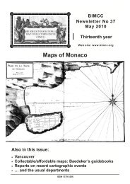
NL38 - Brussels International Map Collectors
NL38 - Brussels International Map Collectors
NL38 - Brussels International Map Collectors

Create successful ePaper yourself
Turn your PDF publications into a flip-book with our unique Google optimized e-Paper software.
Some mysteries have surrounded portolans for a<br />
long time and continue to intrigue researchers. There<br />
is the question of their unknown origin : they turn up<br />
all of a sudden around 1290, in pointed contrast to the<br />
prevailing convention of medieval mappae mundi<br />
centered on Jerusalem. They also appear to have<br />
been drawn consistently with astounding geographical<br />
accuracy, at least as far as the shores of the<br />
Mediterranean basin and of the Black Sea were<br />
concerned. And they continued to be produced well<br />
beyond the time when their practical use for navigation<br />
at sea had come to an end, as they were replaced by<br />
more modern printed charts. However, to the extent<br />
that they progressively lost their utility, they gained in<br />
artistic style, a feature which may account, at least<br />
partly, for their longevity.<br />
There is an abundant literature on these charts,<br />
and recent publications are frequently adorned with<br />
colour reproductions which convey the artistic<br />
dimension of great appeal, common to portolans in<br />
general. One of the best introductions to the subject at<br />
the moment is Prof Astengo’s contribution in Vol. 3 of<br />
the History of Cartography, concentrating on nautical<br />
charts of the 16 th and 17 th century in the Mediterranean<br />
chart making tradition 7 . He states that over 650 charts<br />
and atlases are held in public collections alone and<br />
estimates about one hundred more to be in private<br />
hands. Together with around 180 charts identified by<br />
Tony Campbell as originating prior to 1500 8 it may be<br />
assumed that nearly one thousand portolan charts and<br />
atlases have survived to this day. A recent census by<br />
Richard Pflederer 9 updates this number to an<br />
astonishing 5 711 charts. Based on previous surveys<br />
by Campbell, Astengo and many other scholars,<br />
Pflederer’s analysis goes beyond these both in<br />
geographical coverage and time since he documents<br />
portolan holdings world-wide, recording individual<br />
charts and those bound into atlases, and extends the<br />
period of his research to the mid-18 th century.<br />
The two Cefalù portolans are, of course, registered<br />
in Astengo’s survey, and this entry has been copied<br />
into the Pflederer census.<br />
General aspects and attribution of the Cefalù<br />
portolan charts<br />
As far as could be ascertained, no complete study<br />
of these two charts has been published so far. Let us<br />
therefore turn to Roberto Almagià, the renowned<br />
Italian historian of cartography who, in 1937, shortly<br />
after the two portolans had been added to the Library,<br />
published the following brief note on them in the Italian<br />
Geographical Journal, the Rivista Geografica Italiana 10<br />
(translation by Dominique & Wulf Bodenstein):<br />
7<br />
Astengo, 2007, pp. 174-262. This is an amended and translated version of Astengo 2000.<br />
8<br />
Campbell, 1986, pp. 67-94<br />
9<br />
Pflederer, 2009. See also the review by Gillian Hutchinson in Imago Mundi 62.2 (2010), p. 261.<br />
10 th<br />
Rivista Geografica Italiana, 44 year, Fascicolo I-II, January-April 1937, pp. 84-85<br />
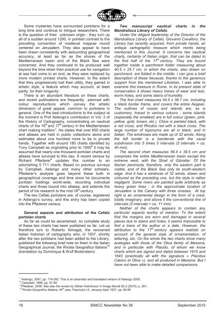
18<br />
Two manuscript nautical charts in the<br />
Mandralisca Library of Cefalù.<br />
Under the diligent leadership of the Director of the<br />
Mandralisca Library of Cefalù, Giovanni Cavalloro, the<br />
Library has recently acquired, from private hands, an<br />
antique cartographic treasure which merits being<br />
mentioned in this Journal. It concerns two nautical<br />
charts, certainly of Italian origin, that can be dated to<br />
the first half of the 17 th century. They are bound<br />
together inside a parchment folder measuring about<br />
40.5 x 28.7 cm, in which the charts, also drawn on<br />
parchment, are folded in the middle. I can give a brief<br />
description of these because, thanks to the generous<br />
support from the mentioned Librarian, I was able to<br />
examine this treasure in Rome. In its present state of<br />
conservation it shows heavy traces of wear and tear,<br />
worm holes, and some stains of humidity.<br />
The first chart measures 54.5 x 38.7 cm, including<br />
a black border frame, and covers the entire Aegean.<br />
The outlines of coasts and islands are, as is<br />
customary, traced in various colours ; some islands<br />
(especially the smallest) are in full colour (green, pink,<br />
yellow, gold, brown, etc.). Chios is painted black, with<br />
a red cross, and Rhodos red with a black cross. The<br />
large number of toponyms are all in black, and in<br />
Italian. The windroses are made up of 32 winds. Along<br />
the left border is a banderole with the usual<br />
subdivision into 5 times 5 intervals (5 intervals = ca.<br />
40 mm).<br />
The second chart measures 56.4 x 39.5 cm and<br />
comprises the entire Mediterranean basin except the<br />
extreme west, with the Strait of Gibraltar. Of the<br />
Iberian peninsula, therefore, only the eastern part is<br />
visible, and of the Black Sea only its south-western<br />
edge. And it has a windrose of 32 winds, drawn and<br />
coloured as the preceding one, but the style is rather<br />
negligent. Some rivers are painted quite arbitrarily as<br />
heavy green lines ; in the approximate location of<br />
Jerusalem is the Calvary with three crosses. At top<br />
right is an ornamental design in the form of a crest,<br />
totally imaginary, and above it the conventional line of<br />
intervals (5 intervals = ca. 11 mm).<br />
Neither of the charts appears to contain any<br />
particular aspects worthy of mention. To the extent<br />
that the margins are worn and damaged in several<br />
places due to stains and holes, it seems impossible to<br />
find a trace of the author or a date. However, the<br />
attribution to the 17 th century appears realistic on<br />
account of the general style of ornamentation, of<br />
lettering, etc. On the whole the two charts show many<br />
analogies with those of the Oliva family of Messina,<br />
and in particular with Placido, of whom we know<br />
charts which are signed and dated between 1615 and<br />
1643 (practically all with the signature « Placidus<br />
Caloiro et Oliva »), and all produced in Messina. But I<br />
have not been able to make detailed comparisons.<br />
BIMCC Newsletter No 38 September 2010