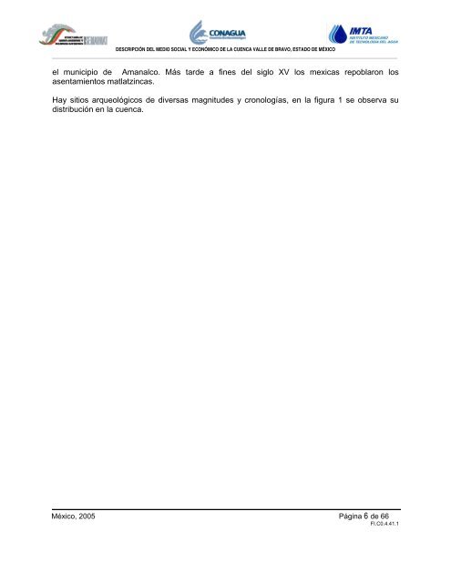
DESCRIPCIÓN DEL MEDIO SOCIAL Y ECONÓMICO DE LA CUENCA VALLE DE BRAVO, ESTADO DE MÉXICO el municipio <strong>de</strong> <strong>Amanalco</strong>. Más tar<strong>de</strong> a fines <strong>de</strong>l siglo XV los mexicas repob<strong>la</strong>ron los asentamientos mat<strong>la</strong>tzincas. Hay sitios arqueológicos <strong>de</strong> diversas magnitu<strong>de</strong>s y cronologías, en <strong>la</strong> figura 1 se observa su distribución en <strong>la</strong> cuenca. México, 2005 Página 6 <strong>de</strong> 66 FI.C0.4.41.1
40 19°20' 35 30 19°15' 20 25 19°10' 15 2,1 10,000 19°05' 100°15' I x t a p a n d e l O r o 70 S a n t o T o m á s O t z o l o a p a n Z a c a z o n a p a n 100°15' 3 70 000 W N S E 75 100°10' 80 75 La B oquil<strong>la</strong> (C erro el Cualtenco <strong>la</strong> Boquil<strong>la</strong>) #S !, !, !, El Cerr illo (San Jo sé El Cerrillo) #S Agua Fría #S Los P ozos (P inar <strong>de</strong> Osorios) #S DESCRIPCIÓN DEL MEDIO SOCIAL Y ECONÓMICO DE LA CUENCA VALLE DE BRAVO, ESTADO DE MÉXICO San Gaspar #S !, !, Cerro G ordo #S !, San Francisco Mihualtepec #S !, San Bartolo #S !, !, San Juan #S !, Santa Maria Pipioltepec (P ipioltepec) #S !, El Arco #S San Antoni o #S !, !, Tres Puentes #S os T #S !, G #S !, !, !, México, 2005 Página 7 <strong>de</strong> 66 FI.C0.4.41.1 !, co # #Y #S El Ancón !, San Mateo Acatit<strong>la</strong>n #S Loma <strong>de</strong> R odríguez #S !, Monte A lto #S Loma <strong>de</strong> !, Chihuahua #S !, Los A <strong>la</strong>mos #S San Simón el Alto #S #S El Trompi llo #S !, !, San G abriel Ixt<strong>la</strong> #S sca !, Ranchería <strong>de</strong> San Martín Obispo #S Nueva Colonia Tres Puentes #S Colonia Rincón Vil<strong>la</strong> <strong>de</strong>l <strong>Valle</strong> #S L izates Barrio <strong>de</strong> uadalupe <strong>Valle</strong> <strong>de</strong> B ravo San Martín Obispo (S an Mar tín San Pedro) #S San Antonio Hidalgo (R anchería <strong>de</strong> S an Antonio) #S San Antonio <strong>de</strong> <strong>la</strong> Laguna #S Mesa <strong>de</strong> Jaimes #S La Mecedora #S La Huerta San A gustín #S San Miguel X ooltepec #S Casas Viejas #S El Aguacate (El Aserr a<strong>de</strong>r o) #S Colonia <strong>Valle</strong> E scondido #S Rancho Espinos Peña B<strong>la</strong>nca #S #S Mata R edonda (Paso H ondo) #S Ejido S an José P otrerillos (E scaleril<strong>la</strong>s) #S 100°10' D o n a t o G u e r r a V i l l a d e A l l e n d e 80 Barranca Fre #S 85 100°05' Mesas <strong>de</strong> San Martín Ejido <strong>la</strong> S abana <strong>de</strong> S an Jerónimo #S #S San Simón <strong>de</strong> <strong>la</strong> Laguna #S Polvillos (San Bar tolo Quinta Sección) #S La Can<strong>de</strong><strong>la</strong>ria #S Rincón <strong>de</strong> E stradas #S Santa Rosa #S !, El Castel <strong>la</strong>no #S La C ompañía (C er ro Colorado) #S La V o<strong>la</strong>nta #S !, 85 100°05' !, San Sebastián el Gran<strong>de</strong> #S Provi<strong>de</strong>ncia (5ta. S ección San Mateo <strong>Amanalco</strong>) #S El Temporal #S La C ompañía (Tres Espigas) Tenantongo #S #S El Fresno (El Fresno <strong>la</strong> Compañía) #S Cuadril<strong>la</strong> <strong>de</strong> D olores #S Ej ido D e San Martín #S Sabana <strong>de</strong>l Madroño ( El Madroño) #S La P alma #S Rancho Avandaro Countr y C lub #S Tier ra Gran<strong>de</strong> (La Loma) #S !, 90 Sabana <strong>de</strong>l R efugio #S Cerro <strong>de</strong> Guadalupe #S Sabana Taborda Primera S ección #S Sabana <strong>de</strong> La Peña (La Peña) #S Sabana <strong>de</strong> San Jerónimo #S La Laguna #S !, Pueblo Nuevo #S Y #S Amanal <strong>de</strong> B ecerr aSan Jerónimo P rimera Sección ( El Convento) #S !, !, San Mateo #S San Sebastián el C hi co #S San Miguel (S an Miguel Tenextepec) #S Santo Tomas el P edregal #S 90 Sabana Taborda Segunda Sección #S Las A hujas #S San Ramón #S !, San Jerónimo #S 95 100°00' #S San Agustín Canohil<strong>la</strong>s S egunda Sección Propiedad Laguna S eca #S El Potrero #S Rincón <strong>de</strong> Guadalupe #S T e m a s c a l t e p e c Figura 1. Mapa <strong>de</strong> sitios arqueológicos <strong>de</strong> <strong>la</strong> <strong>Cuenca</strong> <strong>de</strong> <strong>Valle</strong> <strong>de</strong> <strong>Bravo</strong> 100°00' 95 San Lucas #S El Pedregal #S San Lucas C uarta Sección (San Francisco) #S El Ojo <strong>de</strong> Agua Capil<strong>la</strong> V ieja #S #S Los S aucos #S V i l l a d e V i c t o r i a El Zacatonal #S Corral <strong>de</strong> Piedra #S 400,000 Capulín Primera S ección #S El Capulín Tercera Sección (Palo Mancornado) #S Hacienda N ueva #S 400,000 Agua Bendita #S Huacal Viejo #S 99°55' T e m a s c a l t e p e c 99°55' 05 A l m o l o y a d e J u á r e z 05 Z i n a c a n t e p e c 40 19°20' 35 30 19°15' 25 19°10' 20 15 10 19°05' !, UBICACI ÓN D E LA ZO NA DE ESTUDIO Sitios arqueológicos HIDROLOGÍA LINEAL Corriente <strong>de</strong> agua per enne Fuente: Instituto N acional <strong>de</strong> Antropología e Historia (INAH). 2000. Trabajo <strong>de</strong> campo. Z Cabec eras #S Localida<strong>de</strong>s Zona urbana SIMBOLOGÍA CONVENCIONAL Cuerpo <strong>de</strong> agua SIMBOLOGÍA Corriente <strong>de</strong> agua intermitente Límites municipales Límite <strong>de</strong> <strong>la</strong> cuenca CARRETERAS CURVAS DE NIVEL Carret era pavimentada 300 0 Te rra cería Maestra Brecha (equidistancia <strong>de</strong> 100 metros) Vereda Esca<strong>la</strong> Numérica 1:140,000 Esca<strong>la</strong> Gráfica 5000 0 5000 Metros CARTOGRAFÍA DE REFERENCIA INEGI.1975, 1982, 1999 y 2000. Cartografía Topográfica y Temática esca<strong>la</strong> 1:50,000, en formato analógico y digital, <strong>de</strong> <strong>la</strong>s cartas E14a37, E14a47, E14a36 y E14a46. INEGI. ITER (2000) XII Censo <strong>de</strong> Pob<strong>la</strong>ción y Vivienda 2000, con datos por localidad. IIIGECEM, 2000 . Ortofo tos digital es e scal a 1:10,000 en formato TIFF. Los límites municipales se obtuvieron <strong>de</strong>l IIIGECEM. La validac ión <strong>de</strong> l a informac ión vectorial para <strong>la</strong> zona <strong>de</strong> es tudi o se reali zó medi ante trabajo d e cam po y con apoyo <strong>de</strong> <strong>la</strong>s ortofotos digital es. INFORMACIÓN DE REFERENCIA Proyección: Universal Transversa <strong>de</strong> Mercator (UTM). Elipsoi<strong>de</strong>: GRS 80. Datum: ITRF92. Falso Este: 500,000. Falso Norte: 0.0 GERENCIA REGIONAL DE AGUAS DEL VALLE DE MÉXICO Y SISTEMA CUTZAMALA GERENCIA DE ORGANISMOS DEL AGUA PROYECTO "PLAN PARA LA GE STIÓN IN TEGRAL DEL AGUA Y RE CU RSOS ASOCIADOS DE LA CUENCA V ALLE DE BRA VO, ESTADO DE MÉXICO" REVISÓ ING. EDG AR OR TEGA FLOR ES JEFE DE PRO YEC TO C O N A G U A Comisión Nacional <strong>de</strong>l Agua MAPA DE SITIOS ARQUEOLÓGICOS DE LA CUENCA VALLE DE BRAVO, ESTADO DE MÉXICO AP R OB Ó M. Sc. G UILLERMO RENTERÍA D EL MAR GERENTE DE ORG ANISMOS D EL AG UA Meridiano Central : -99.0 Cuadrícu<strong>la</strong> UTM: a cada 5,000 metros. Cuadrícu<strong>la</strong> Geográfica: a cada 5 minutos. Referencia <strong>de</strong> <strong>la</strong>s cotas: Nivel medio <strong>de</strong>l mar. CONFO RME ING. JO RGE MAL AG ÓN DÍAZ GERENTE REG ION AL