

Contenido de la Memoria Tcnica - Cuenca Valle de Bravo-Amanalco
Contenido de la Memoria Tcnica - Cuenca Valle de Bravo-Amanalco
Contenido de la Memoria Tcnica - Cuenca Valle de Bravo-Amanalco

Create successful ePaper yourself
Turn your PDF publications into a flip-book with our unique Google optimized e-Paper software.
DESCRIPCIÓN DEL MEDIO SOCIAL Y ECONÓMICO DE LA CUENCA VALLE DE BRAVO, ESTADO DE MÉXICO<br />
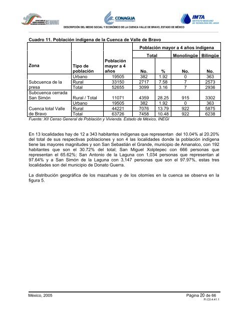
Cuadro 11. Pob<strong>la</strong>ción indígena <strong>de</strong> <strong>la</strong> <strong>Cuenca</strong> <strong>de</strong> <strong>Valle</strong> <strong>de</strong> <strong>Bravo</strong><br />
Pob<strong>la</strong>ción mayor a 4 años indígena<br />
Total Monolingüe Bilingüe<br />
Zona Tipo <strong>de</strong><br />
Pob<strong>la</strong>ción<br />
mayor a 4<br />
pob<strong>la</strong>ción años No. % No. No.<br />
Urbano 19505 382 1.92 0 363<br />
Subcuenca <strong>de</strong> <strong>la</strong> Rural 33150 2717 7.58 7 2573<br />
presa<br />
Subcuenca cerrada<br />
Total 52655 3099 3.16 7 2936<br />
San Simón Rural / Total 11071 4359 28.25 915 3302<br />
Urbano 19505 382 1.92 0 363<br />
<strong>Cuenca</strong> total <strong>Valle</strong> Rural 44221 7076 13.79 922 5875<br />
<strong>de</strong> <strong>Bravo</strong> Total 63726 7458 10.48 922 6238<br />
Fuente: XII Censo General <strong>de</strong> Pob<strong>la</strong>ción y Vivienda. Estado <strong>de</strong> México, INEGI<br />
En 13 localida<strong>de</strong>s hay <strong>de</strong> 12 a 343 habitantes indígenas que representan <strong>de</strong>l 10.04% al 20.20%<br />
<strong>de</strong>l total <strong>de</strong> sus respectivas pob<strong>la</strong>ciones y son 4 <strong>la</strong>s localida<strong>de</strong>s don<strong>de</strong> <strong>la</strong> pob<strong>la</strong>ción indígena<br />
tiene <strong>la</strong>s mayores magnitu<strong>de</strong>s y son San Sebastián el Gran<strong>de</strong>, municipio <strong>de</strong> <strong>Amanalco</strong>, con 192<br />
habitantes que son el 30.72% <strong>de</strong>l total; San Miguel Xolptepec con 666 personas que<br />
representan el 65.62%; San Antonio <strong>de</strong> <strong>la</strong> Laguna con 1,034 personas que representan al<br />
97.64% y a San Simón <strong>de</strong> <strong>la</strong> Laguna con 3,147 personas que son el 97.97%, estas tres<br />
localida<strong>de</strong>s son <strong>de</strong>l municipio <strong>de</strong> Donato Guerra.<br />
La distribución geográfica <strong>de</strong> los mazahuas y <strong>de</strong> los otomíes en <strong>la</strong> cuenca se observa en <strong>la</strong><br />
figura 5.<br />
México, 2005 Página 20 <strong>de</strong> 66<br />
FI.C0.4.41.1