Análisis de la Situación Global del Municipio de Tartagal ...
Análisis de la Situación Global del Municipio de Tartagal ...
Análisis de la Situación Global del Municipio de Tartagal ...

You also want an ePaper? Increase the reach of your titles
YUMPU automatically turns print PDFs into web optimized ePapers that Google loves.
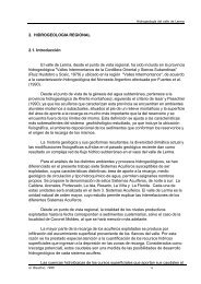
Altitud<br />
1300<br />
1200<br />
1100<br />
1000<br />
900<br />
800<br />
700<br />
600<br />
500<br />
400<br />
300<br />
200<br />
100<br />
0<br />
Diagnóstico Ambiental Departamento San Martín – Municipalidad <strong>de</strong> <strong>Tartagal</strong><br />
R 2 = 0,9839<br />
0 10 20 30 40 50 60 70 80 90 100<br />
% <strong>de</strong> Superficie Acumu<strong>la</strong>da<br />
A partir <strong>de</strong> <strong>la</strong> curva hipsométrica calcu<strong>la</strong>da, se empleo como estadístico a<br />
<strong>la</strong> mediana por consi<strong>de</strong>rarse mas representativa que <strong>la</strong> media, a partir <strong>de</strong> <strong>la</strong><br />
mediana se obtuvo una altitud <strong>de</strong> 750 m. aproximadamente, lo que indica que<br />
por encima y por <strong>de</strong>bajo <strong>de</strong> este valor queda <strong>de</strong>finida <strong>la</strong> mitad <strong>de</strong> <strong>la</strong> cuenca<br />
aguas arriba y abajas abajo.<br />
Definición <strong>de</strong> <strong>la</strong> cuenca alta, media y baja <strong>de</strong>l río <strong>Tartagal</strong>.<br />
Con una visión <strong>de</strong> manejo a futuro se opto por dividir <strong>la</strong> cuenca en alta,<br />
media y baja según los siguientes criterios.<br />
1. Altitud.<br />
2. Curvas <strong>de</strong> nivel.<br />
3. Pendientes.<br />
4. Activida<strong>de</strong>s antrópicas involucradas en <strong>la</strong> cuenca.<br />
A partir <strong>de</strong> los criterios recientemente citados, <strong>la</strong> cuenca quedo <strong>de</strong>finida<br />
en tres áreas <strong>de</strong> manejo cuyas superficies son:<br />
1. Cuenca Alta: 8087, 8823 ha.<br />
2. Cuenca Media: 1746,3992 ha.<br />
3. Cuenca Baja: 3816,0655 ha.<br />
A continuación se presentan el P<strong>la</strong>no <strong>de</strong> <strong>la</strong> Cuenca <strong>de</strong>l Río <strong>Tartagal</strong><br />
sectorizado y el los P<strong>la</strong>no a <strong>de</strong>talle <strong>de</strong> <strong>la</strong> cuenca alta, media y baja.<br />
Página 52 <strong>de</strong> 179 Ing. C. M. Cabral e Ing. G. P<strong>la</strong>za