Plan de muestreo de áreas para la región Sierra
Plan de muestreo de áreas para la región Sierra
Plan de muestreo de áreas para la región Sierra

Create successful ePaper yourself
Turn your PDF publications into a flip-book with our unique Google optimized e-Paper software.
Diseño<br />
Muestral y Construcción<br />
<strong>de</strong>l Marco <strong>de</strong> Muestreo <strong>de</strong> Area en <strong>la</strong> Región <strong>Sierra</strong><br />
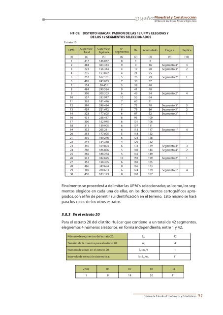
HT-09:<br />
Estrato:10<br />
DISTRITO HUACAR: PADRON DE LAS 12 UPM’s ELEGIDAS Y<br />
DE LOS 12 SEGMENTOS SELECCIONADOS<br />
UPM<br />
Superficie Superficie N°<br />
Total Agríco<strong>la</strong> segmentos<br />
Acumu<strong>la</strong>do Elegir a Replica<br />
(1) (4) (5) (6) (7) (8) (9) (10)<br />
1 417 146.067 8 1 8<br />
2 484 363.333 9 9 16 Segmento 4° 3<br />
3 223 156.344 4 17 20 Segmento 3° 2<br />
4 235 153.072 4 21 25<br />
5 257 167.101 5 26 29 Segmento 2° 1<br />
6 405 243.033 7 30 37<br />
7 154 69.451 3 38 40<br />
8 484 290.524 9 41 48<br />
9 308 200.303 6 49 54 Segmento 2° 4<br />
10 557 333.947 10 55 64<br />
11 363 181.476 7 65 71<br />
12 399 299.484 7 72 78 Segmento 3° 3<br />
13 459 321.612 8 79 86 Segmento 3° 2<br />
14 323 177.805 6 87 92 Segmento 3° 1<br />
16 431 258.417 8 93 100<br />
17 306 152.945 6 101 106<br />
18 311 139.905 6 107 111<br />
19 332 265.211 6 112 117 Segmento 1° 4<br />
20 253 177.005 5 118 122<br />
21 339 169.276 6 123 128<br />
22 244 134.368 4 129 132<br />
23 340 169.894 6 133 139 Segmento 4° 3<br />
24 288 186.876 5 140 144 Segmento 4° 2<br />
25 269 188.284 5 145 149<br />
26 541 432.695 10 150 159 Segmento 2° 1<br />
27 352 158.305 6 160 165<br />
28 466 349.694 8 166 173<br />
29 309 200.653 6 174 179 Segmento 1° 4<br />
30 458 183.193 8 180 187<br />
De<br />
Finalmente, se proce<strong>de</strong>rá a <strong>de</strong>limitar <strong>la</strong>s UPM´s seleccionadas; así como, los segmentos<br />
elegidos en cada una <strong>de</strong> el<strong>la</strong>s, en los documentos cartográficos apropiados,<br />
con el fin <strong>de</strong> permitir su i<strong>de</strong>ntificación en el terreno. Esto mismo se hará<br />
<strong>para</strong> los casos <strong>de</strong> los otros estratos.<br />
5.8.3 En el estrato 20<br />
Para el estrato 20 <strong>de</strong>l distrito Huácar que contiene a un total <strong>de</strong> 42 segmentos,<br />
elegiremos 4 números aleatorios, en forma in<strong>de</strong>pendiente, entre 1 y 42.<br />
Número <strong>de</strong> segmentos <strong>de</strong>l estrato 20: S h0 42<br />
Tamaño <strong>de</strong> <strong>la</strong> muestra <strong>para</strong> el estrato 20: n h 4<br />
Numero <strong>de</strong> zonas en el estrato 20: Z h =n h /4 1<br />
Intervalo <strong>de</strong> selección sistemática: k=S 0h /n h 11<br />
Zona R1 R2 R3 R4<br />
1 8 19 30 41<br />
Oficina <strong>de</strong> Estudios Económicos y Estadísticos<br />
41