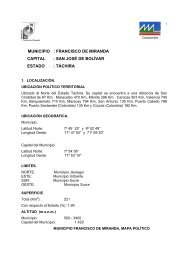
Michelena - CORPOANDES
Michelena - CORPOANDES
Michelena - CORPOANDES

You also want an ePaper? Increase the reach of your titles
YUMPU automatically turns print PDFs into web optimized ePapers that Google loves.
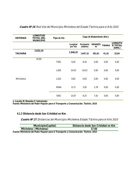
Cuadro Nº 26. Red Vial del Municipio <strong>Michelena</strong> del Estado Táchira para el Año 2010<br />
ENTIDAD<br />
TÁCHIRA<br />
LONGITUD<br />
TOTAL DEL<br />
MUNICIPIO<br />
2.022,10<br />
Tipo de Vía<br />
Longitud<br />
por Vía<br />
1.946,32<br />
Capa de Rodamiento (Km.)<br />
Pavimento<br />
asfáltico<br />
GRANZO<br />
N<br />
TIERRA<br />
LONGITU<br />
D TOTAL<br />
(KMS.)<br />
1.647,15 301,81 41,10 32,04<br />
45,85<br />
T001 8,44 8,44 0,00 0,00 0,00<br />
L005 24,03 24,03 0,00 0,00 0,00<br />
<strong>Michelena</strong><br />
L010 6,65 6,65 0,00 0,00 0,00<br />
R046 6,73 3,95 2,78 0,00 0,00<br />
S061 15,67 8,25 7,42 0,00 0,00<br />
L: Locales R: Ramales S: Subramales<br />
Fuente: Ministerio del Poder Popular para el Transporte y Comunicación. Táchira. 2010<br />
6.1.2 Distancia desde San Cristóbal en Km.<br />
Cuadro Nº 27. Distancias del Municipio <strong>Michelena</strong> Estado Táchira para el Año 2010<br />
Municipio(Capital)<br />
Distancia desde San Cristóbal en Km<br />
<strong>Michelena</strong> ( <strong>Michelena</strong>) 37,00<br />
Fuente: Ministerio del Poder Popular para el Transporte y Comunicación. Táchira. 2010