PLAN DE GESTIÓN INTEGRAL DE RESIDUOS SÓLIDOS - Florián
PLAN DE GESTIÓN INTEGRAL DE RESIDUOS SÓLIDOS - Florián
PLAN DE GESTIÓN INTEGRAL DE RESIDUOS SÓLIDOS - Florián

Create successful ePaper yourself
Turn your PDF publications into a flip-book with our unique Google optimized e-Paper software.
PGIRS-MUNICIPIO <strong>DE</strong> FLORIAN -SANTAN<strong>DE</strong>R Documento de Diagnóstico<br />
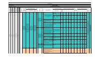
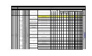
Tabla 5. Pendiente del terreno<br />
INTERVALOS PORCENTAJES CARACTERISTICAS<br />
1 0 –3 Plano<br />
2 3 – 7 Levemente Inclinado<br />
3 7 – 12 Inclinado<br />
4 12 – 25 Moderadamente Empinado<br />
5 25 – 50 Empinado<br />
6 50 – 75 Escarpado<br />
7 > 75 Muy escarpado.<br />
Fuente: EOT <strong>Florián</strong><br />
El municipio de <strong>Florián</strong> se caracteriza por presentar un rango de pendientes planas,<br />
levemente inclinadas al sur-oriente del municipio en las veredas de influencia del casco<br />
urbano.<br />
La zona central, norte y occidental del municipio se caracteriza por presentar un rango de<br />
pendientes moderadamente inclinadas, empinadas, escarpadas y muy escarpadas.<br />
Porcentaje de pendiente y área<br />
1 % de Pendiente Área-en Has % Del área total del<br />
municipio<br />
2 0% a 7% 283.48 1.54%<br />
3 7% a 25% 3.161.38 17.27%<br />
4 25% a 50% 7.605.77 Has 41.55%<br />
5 50% a 75% 4.775.05 26.09%<br />
6 Mayor del 75% 2.476.39 13.53%<br />
TOTAL 18.3021.00 100%<br />
Fuente: EOT <strong>Florián</strong><br />
1.2.4 Geomorfología<br />
Tabla 6. Unidades Geomorfológicos de Origen denudacional y aluvial<br />
CODIGO UNIDAD CARACTERISTICAS<br />
UNIDA<strong>DE</strong>S <strong>DE</strong> ORIGEN ALUVIAL<br />
AREA<br />
HAS<br />
Instituto CINARA - Universidad del Valle UNICEF<br />
14<br />
%