- Page 1 and 2: 1
- Page 3 and 4: Contenido Planeación Estratégica
- Page 5 and 6: Cantidad de maestros y alumnos en e
- Page 7 and 8: Presentación Planeación Estratég
- Page 9 and 10: Estoy poniendo en sus manos el Plan
- Page 11 and 12: 1. Ecoturismo como Impulsor del Des
- Page 13 and 14: seguridad de las personas y su patr
- Page 15 and 16: Desarrollo en el ámbito federal, a
- Page 17 and 18: Así también en la fracción XXI d
- Page 19 and 20: aparato administrativo municipal, l
- Page 21 and 22: Transparencia y Discreción: Pondre
- Page 23 and 24: Marco Metodológico El Municipio es
- Page 25 and 26: Transparencia de la Gestión Públi
- Page 27 and 28: En 1924 Tapachula es declarada como
- Page 29 and 30: C. Judith Liliana Morales Ramírez
- Page 31 and 32: Comisión de Desarrollo Socioeconó
- Page 33 and 34: 8. Secretaría de Seguridad Públic
- Page 35 and 36: garantizar las condiciones de paz s
- Page 37 and 38: Instituto Municipal para la Cultura
- Page 39 and 40: quincena normal, 450 son personal e
- Page 41 and 42: Decisión A. La policía municipal
- Page 43 and 44: Aspectos de Protección Civil En nu
- Page 45 and 46: Aspectos del Sistema Municipal para
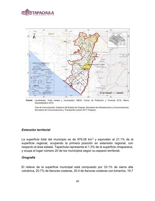
- Page 47: Organigrama Medio físico Colindanc
- Page 51 and 52: Clima Fuente: INEGI, Carta de Clima
- Page 53 and 54: Mapa de riesgo Municipal Identifica
- Page 55 and 56: y que además cuenta con mar en la
- Page 57 and 58: Altitud Como ya se mencionó en el
- Page 59 and 60: 2000 mm (7.45%), de 2000 a 2300 mm
- Page 61 and 62: indígena. Es importante resaltar q
- Page 63 and 64: vez fabricado, se expone el día de
- Page 65 and 66: ya que sus tumbas y capillas expres
- Page 67 and 68: 70890424 ALTAMIRA 154 70890050 BENI
- Page 69 and 70: BOLSA DE LA BOTELLA) 70891020 FRONT
- Page 71 and 72: 70890630 RÍO FLORIDO 789 70890714
- Page 73 and 74: Distribución y clasificación de a
- Page 75 and 76: Sandino Loc. de 40% y más 1 1 Tota
- Page 77 and 78: EL ENCANTO 1,726 67.71 21.97 93.95
- Page 79 and 80: LA CIG\EÑA 367 50.52 35.05 7.22 39
- Page 81 and 82: PACAYALITO DOS 646 60.42 37.50 100.
- Page 83 and 84: SANTA ELENA 251 25.00 1.56 4.69 3.1
- Page 85 and 86: El acceso a los servicios básicos
- Page 87 and 88: POBLACIÓN URBANA % DE POBLACIÓN U
- Page 89 and 90: 4.5 en los subsecuentes, la dinámi
- Page 91 and 92: Existen cuestiones asociadas a la m
- Page 93 and 94: participación tuvo en la economía
- Page 95 and 96: Respecto al sector terciario, las p
- Page 97 and 98: migración, cuenta también con ins
- Page 99 and 100:
En este contexto según los resulta
- Page 101 and 102:
Cantidad de maestros y alumnos en e
- Page 103 and 104:
Fuente: Secretaría de Educación d
- Page 105 and 106:
1.2.2. Planeación y gestión públ
- Page 107 and 108:
3.1.2. Ganadería responsable. 3.1.
- Page 109 and 110:
1.4. Garantizar un Sistema de Justi
- Page 111 and 112:
IV. MÉXICO PRÓSPERO ELIMINAR LAS
- Page 113 and 114:
La propuesta de trabajo del gobiern
- Page 115 and 116:
115
- Page 117 and 118:
Nuestra visión apunta a hacer de T
- Page 119 and 120:
De la misma forma en coordinación
- Page 121 and 122:
1.1.1.7.- Promocionar la oferta tur
- Page 123 and 124:
1.1.2.21.- Realizar y fomentar even
- Page 125 and 126:
Eje 2.- Fomento y Gestión para el
- Page 127 and 128:
de los cuales el 89.2% emplean de 1
- Page 129 and 130:
de mejores oportunidades de empleo,
- Page 131 and 132:
Además de la producción agrícola
- Page 133 and 134:
Es impostergable que se lleven a ca
- Page 135 and 136:
2.1.1.12.- Promocionar a empresario
- Page 137 and 138:
2.1.5.10.- Planear y realizar reuni
- Page 139 and 140:
2.2.1.17.- Gestionar ante SAGARPA l
- Page 141 and 142:
Para enfrentar el deterioro ambient
- Page 143 and 144:
2.4.2.3.- Promover la cultura ecol
- Page 145 and 146:
Estrategia 2.4.7.- Reforestación d
- Page 147 and 148:
2.5.1.9.- Abrir nuevas rutas de rec
- Page 149 and 150:
Eje 3.- Infraestructura para Impuls
- Page 151 and 152:
En relación al tema de las localid
- Page 153 and 154:
central al Par Vial, 1ª avenida su
- Page 155 and 156:
La labor del gobierno municipal es
- Page 157 and 158:
Los derechos humanos juegan un pape
- Page 159 and 160:
La capacidad de realizar infraestru
- Page 161 and 162:
3.3.1.5.- Identificar sitios adecua
- Page 163 and 164:
163
- Page 165 and 166:
para apoyar la realización de las
- Page 167 and 168:
Nosotros entendemos que el fortalec
- Page 169 and 170:
No obstante, el 60.7% de la poblaci
- Page 171 and 172:
Según la Organización de las Naci
- Page 173 and 174:
La oferta cultural institucional es
- Page 175 and 176:
Debemos reconocer que la participac
- Page 177 and 178:
Uno de los problemas más sentidos
- Page 179 and 180:
Intervención Gubernamental Políti
- Page 181 and 182:
Líneas de Acción: 4.1.3.1.- Brind
- Page 183 and 184:
Estrategia 4.1.7.- Desarrollar acci
- Page 185 and 186:
Estrategia 4.2.1.- Diseñar accione
- Page 187 and 188:
4.2.5.3.- Construcción de un Centr
- Page 189 and 190:
Líneas de Acción: 4.2.9.1.- Promo
- Page 191 and 192:
4.3.1.16.- Gestionar la creación d
- Page 193 and 194:
4.3.5.3.- Realizar el Festival de l
- Page 195 and 196:
Parte de nuestra estrategia será v
- Page 197 and 198:
Soy un convencido de que las mujere
- Page 199 and 200:
Estrategia 4.5.4.- Establecer la Ru
- Page 201 and 202:
Estrategia 4.6.1.- Establecer acuer
- Page 203 and 204:
Con el ejercicio efectivo de la par
- Page 205 and 206:
Líneas de Acción: 4.7.4.1.- Insta
- Page 207 and 208:
Eje 5.- Modernización y Transparen
- Page 209 and 210:
El desfase en la comprobación del
- Page 211 and 212:
La planificación del desarrollo mu
- Page 213 and 214:
La intención primordial es la apli
- Page 215 and 216:
autoridades correspondientes. Esta
- Page 217 and 218:
en su gobierno municipal. Informare
- Page 219 and 220:
5.1.3.7.- Establecer un programa de
- Page 221 and 222:
Estrategia 5.2.1.- Instalar el Comi
- Page 223 and 224:
5.2.4.1.- Desarrollar la página y
- Page 225 and 226:
5.3.1.2.- Fincar responsabilidades
- Page 227 and 228:
Estableceremos medidas administrati
- Page 229 and 230:
5.4.4.3.- Establecer un programa de
- Page 231 and 232:
Eje 6.- Servicios Públicos Eficace
- Page 233 and 234:
A la par de los servicios públicos
- Page 235 and 236:
mencionados, en Tapachula se tiene
- Page 237 and 238:
Sin embargo estos centros de poblac
- Page 239 and 240:
6.1.1.3.- Incentivar el uso de suel
- Page 241 and 242:
6.2.2.3.- Destinar recursos para la
- Page 243 and 244:
6.2.5.3.- Gestionar capacitación a
- Page 245 and 246:
Asimismo, el correcto manejo de las
- Page 247 and 248:
6.3.3.2.- Promocionar el uso de dis
- Page 249 and 250:
6.4.3.6.- Elaborar una base de dato
- Page 251 and 252:
Eje 7.- Seguridad Para Todos Objeti
- Page 253 and 254:
trabajo conjunto, tanto de la socie
- Page 255 and 256:
vigilancia y manejo de los congesti
- Page 257 and 258:
El estado de Chiapas es uno de los
- Page 259 and 260:
7.1.1.2.- Realizar reuniones conjun
- Page 261 and 262:
Líneas de Acción: 7.1.4.1.- Reali
- Page 263 and 264:
Objetivo 7.2.- Mejorar la seguridad
- Page 265 and 266:
manejo integral de riesgos de desas
- Page 267 and 268:
7.3.4.3.- Estandarizar los servicio
- Page 269 and 270:
Participación Foros participativos
- Page 271 and 272:
Ambiental 3.- Infraestructura para
- Page 273 and 274:
Las demás que determine la Asamble
- Page 275 and 276:
Instalación del Comité de Planeac
- Page 277 and 278:
277
- Page 279 and 280:
Seguimiento y Evaluación Para el s
- Page 281 and 282:
Para cumplir con lo dispuesto en el
- Page 283 and 284:
Matriz de marco lógico Eje 1: Ecot
- Page 285 and 286:
Eje 3: Infraestructura para Impulsa
- Page 287 and 288:
Eje 5: Modernización y Transparenc
- Page 289 and 290:
Eje 7: Seguridad para todos Lógica
- Page 291 and 292:
del Programa de las Naciones Unidas
- Page 293 and 294:
293
- Page 295 and 296:
295
- Page 297 and 298:
297
- Page 299 and 300:
299
- Page 301 and 302:
301
- Page 303 and 304:
303
- Page 305 and 306:
305
- Page 307 and 308:
307
- Page 309 and 310:
309
- Page 311 and 312:
311
- Page 313 and 314:
313
- Page 315 and 316:
315
- Page 317 and 318:
317
- Page 319 and 320:
319
- Page 321 and 322:
321
- Page 323 and 324:
323
- Page 325 and 326:
325
- Page 327 and 328:
327
- Page 329 and 330:
329
- Page 331 and 332:
331
- Page 333 and 334:
333
- Page 335 and 336:
335
- Page 337 and 338:
337
- Page 339 and 340:
339
- Page 341 and 342:
341
- Page 343 and 344:
Reactivar el Parque Agroindustrial
- Page 345 and 346:
Estrategia 2: Establecer mecanismo
- Page 347 and 348:
Matriz de Programa de Inversión Ge
- Page 349 and 350:
Atlas de Riesgos Naturales del Muni
- Page 351 and 352:
351
- Page 353 and 354:
Indicadores del Municipio de Tapach
- Page 355 and 356:
SUPERFICIE Y PRODUCCIÓN AGRICOLA D
- Page 357 and 358:
CONEVAL Informe anual sobre la situ
- Page 359 and 360:
359
- Page 361 and 362:
jardín de niños Fernando castaã
- Page 363 and 364:
escuela de natación club acuarius
- Page 365 and 366:
oyall ballet center escuelas de art
- Page 367 and 368:
escuela primaria Jaime Sabines escu
- Page 369 and 370:
escuela kínder teodomiro palacios
- Page 371 and 372:
capep xlii escuelas del sector púb
- Page 373 and 374:
0890714AYS 2 KM DE TUBERIA PARA AGU
- Page 375 and 376:
0890706AYS 500 MTS DE TUBERIA PARA
- Page 377 and 378:
0890001AYS CONSTRUCCIÓN DE UN DREN
- Page 379 and 380:
0891017AYS CONSTRUCCIÓN DE DRENAJE
- Page 381 and 382:
0890710VIV AMPLIACIÓN DE ENERGÍA
- Page 383 and 384:
0890001VIV MATERIAL PISO TAPACHULA
- Page 385 and 386:
0890001VIV 0890001VIV 0890001VIV 08
- Page 387 and 388:
0890460SAL CONSTRUCCIÓN DE CLÍNIC
- Page 389 and 390:
0890001URB AMPLIACIÓN ALUMBRADO P
- Page 391 and 392:
0890197URB ARREGLO DE CAMINOS CON B
- Page 393 and 394:
0890294URB PAVIMENTACIÓN MIXTA DE
- Page 395 and 396:
0890001URB 0890001URB BACHEO PAVIME
- Page 397 and 398:
0890001URB PAVIMENTACIÓN DE CALLES
- Page 399 and 400:
0890001URB PAVIMENTACION DE CALLES
- Page 401 and 402:
0890405URB PAVIMENTACION EN CALLES
- Page 403 and 404:
0890077URB 0890200URB 0890749URB 08
- Page 405 and 406:
0890106URB PAVIMENTACIÓN ENTRADA P
- Page 407 and 408:
0890746URB PAVIMENTACION DE I KM DE
- Page 409 and 410:
0890115URB PAVIMENTACIÓN Y CONSTRU
- Page 411 and 412:
0890115ED TECHADO, BARDA PERIMETRAL
- Page 413 and 414:
0890001ED CONSTRUCCIÓN DE SERVICIO
- Page 415 and 416:
0890095ED CONSTRUCCIÓN DE UN AULA,
- Page 417 and 418:
0890462ED 0890308ED BARDA PERIMETRA
- Page 419 and 420:
PARQUE DEL EJIDO 20 DE NOVIEMBRE 1