C'est tellement facile: - TELE-satellite International Magazine
C'est tellement facile: - TELE-satellite International Magazine
C'est tellement facile: - TELE-satellite International Magazine

Create successful ePaper yourself
Turn your PDF publications into a flip-book with our unique Google optimized e-Paper software.
■<br />
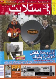
An example from the satbeams.com website: the footprint of EUROBIRD 9A is projected online<br />
onto Google Maps. You can zoom into and out of the map with the footprints matching each<br />
individual map. Satbeams has created an electronic version of the footprint of every <strong>satellite</strong>.<br />
Professional users can license the data and then use the data on their own website.<br />
in 2006 and after few months of hesitation<br />
he decided to implement this idea.<br />
“In the Fall of 2007 I contracted several<br />
talented programmers who helped me<br />
develop the necessary software as well<br />
as electronically convert the <strong>satellite</strong><br />
footprints”, he explains. In the middle of<br />
2008 the web site went online with its<br />
first version. Initially, Alexander wanted<br />
to use the domain name “satcoverage”<br />
but a friend suggested that “satbeams”<br />
would be better. “That name is short,<br />
easy to remember and gets right to the<br />
point”, he says.<br />
At first Alexander Derjugin wanted to<br />
gear his website<br />
more<br />
■<br />
<br />
Brussels<br />
towards <strong>satellite</strong> DXers, in other words<br />
towards hobbyists. He implemented the<br />
solution that <strong>satellite</strong> DXers could click<br />
on their location via Google Maps and<br />
then enter in realistic reception results.<br />
But he wasn’t satisfied with the results<br />
and decided to redesign the website. In<br />
July 2009 the new version of Satbeams<br />
went live.<br />
Now almost every <strong>satellite</strong> footprint<br />
from around the world was digitized and<br />
could be projected onto Google Maps.<br />
“Dozens of volunteers help me keep<br />
all of the <strong>satellite</strong> data up-to-date”, he<br />
says. So in addition to <strong>satellite</strong> technical<br />
details and footprints all of the associated<br />
transponder data is also displayed.<br />
Now he’s in the process of<br />
making his website more<br />
user-friendly. “I am focused<br />
on ‘usability’ to improve<br />
the user experience”, he<br />
explains, “you can search<br />
by channel name or your<br />
address and filter the<br />
104 <strong>TELE</strong>-<strong>satellite</strong> — Global Digital TV <strong>Magazine</strong> — 10-11/2010 — www.<strong>TELE</strong>-<strong>satellite</strong>.com<br />
charts by any field like ‘language’ or<br />
‘band’. All of the data is linked together<br />
and you can reach almost any information<br />
with just 2-3 clicks of the mouse.”<br />
Alexander is constantly thinking about<br />
how he can make his website even more<br />
user-friendly. “But above all I want to<br />
reach out to professionals and implement<br />
additional features that would be<br />
useful for them. For example <strong>satellite</strong><br />
providers would be interested to know if<br />
their footprint overlaps with footprints of<br />
other <strong>satellite</strong>s.” So Alexander is thinking<br />
of the best way to overlay multiple<br />
footprints on the worlds map which would<br />
make it easy to see what <strong>satellite</strong>s cover<br />
the same area.<br />
He sees the future of Satbeams with<br />
specialised applications. “Interested<br />
companies could license the footprint<br />
data from me”, says Alexander Derjugin,<br />
“with the monthly licensing fee the footprint<br />
updates are locked in.”<br />
What kind of companies could use his<br />
services? “First and foremost would be<br />
Internet-via-Satellite providers”, comments<br />
Alexander Derjugin, “Satbeam’s<br />
first customers came from this sector.<br />
The footprint data would also be interesting<br />
for uplink stations, for <strong>satellite</strong> providers<br />
and also for SNG operators who<br />
need to find the proper footprint for their<br />
VSAT systems.”<br />
Alexander Derjugin discovered an<br />
interesting market segment with Satbeams.<br />
A website geared specifically<br />
towards the <strong>satellite</strong> professionals seems<br />
to be a very good idea!<br />
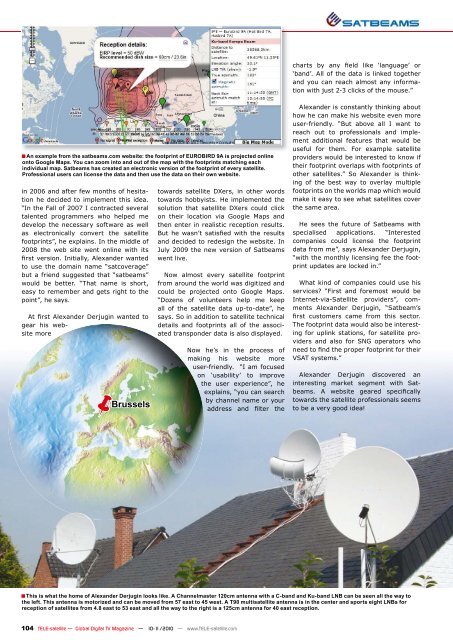
This is what the home of Alexander Derjugin looks like. A Channelmaster 120cm antenna with a C-band and Ku-band LNB can be seen all the way to<br />
the left. This antenna is motorized and can be moved from 57 east to 45 west. A T90 multi<strong>satellite</strong> antenna is in the center and sports eight LNBs for<br />
reception of <strong>satellite</strong>s from 4.8 east to 53 east and all the way to the right is a 125cm antenna for 40 east reception.