Loi sur les compagnies Companies Act - Gouvernement du ...
Loi sur les compagnies Companies Act - Gouvernement du ...
Loi sur les compagnies Companies Act - Gouvernement du ...

You also want an ePaper? Increase the reach of your titles
YUMPU automatically turns print PDFs into web optimized ePapers that Google loves.
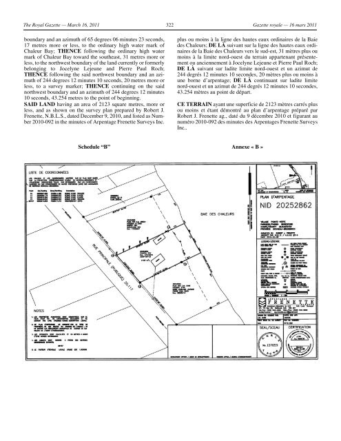
The Royal Gazette — March 16, 2011 322 Gazette royale — 16 mars 2011<br />
boundary and an azimuth of 65 degrees 06 minutes 23 seconds,<br />
17 metres more or <strong>les</strong>s, to the ordinary high water mark of<br />
Chaleur Bay; THENCE following the ordinary high water<br />
mark of Chaleur Bay toward the southeast, 31 metres more or<br />
<strong>les</strong>s, to the northwest boundary of the land currently or formerly<br />
belonging to Jocelyne Lejeune and Pierre Paul Roch;<br />
THENCE following the said northwest boundary and an azimuth<br />
of 244 degrees 12 minutes 10 seconds, 20 metres more or<br />
<strong>les</strong>s, to a <strong>sur</strong>vey marker; THENCE continuing on the said<br />
northwest boundary and an azimuth of 244 degrees 12 minutes<br />
10 seconds, 43.254 metres to the point of beginning.<br />
SAID LAND having an area of 2123 square metres, more or<br />
<strong>les</strong>s, and as shown on the <strong>sur</strong>vey plan prepared by Robert J.<br />
Frenette, N.B.L.S., dated December 9, 2010, and listed as Number<br />
2010-092 in the minutes of Arpentage Frenette Surveys Inc.<br />
Sche<strong>du</strong>le “B”<br />
plus ou moins à la ligne des hautes eaux ordinaires de la Baie<br />
des Chaleurs; DE LÀ suivant <strong>sur</strong> la ligne des hautes eaux ordinaires<br />
de la Baie des Chaleurs vers le sud-est, 31 mètres plus ou<br />
moins à la limite nord-ouest <strong>du</strong> terrain appartenant présentement<br />
ou anciennement à Jocelyne Lejeune et Pierre Paul Roch;<br />
DE LÀ suivant <strong>sur</strong> ladite limite nord-ouest et un azimut de<br />
244 degrés 12 minutes 10 secondes, 20 mètres plus ou moins à<br />
une borne d’arpentage; DE LÀ continuant <strong>sur</strong> ladite limite<br />
nord-ouest et un azimut de 244 degrés 12 minutes 10 secondes,<br />
43.254 mètres au point de départ.<br />
CE TERRAIN ayant une superficie de 2123 mètres carrés plus<br />
ou moins et étant démontré au plan d’arpentage préparé par<br />
Robert J. Frenette ag., daté <strong>du</strong> 9 décembre 2010 et figurant au<br />
numéro 2010-092 des minutes des Arpentages Frenette Surveys<br />
Inc..<br />
Annexe « B »