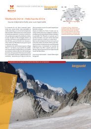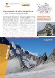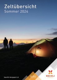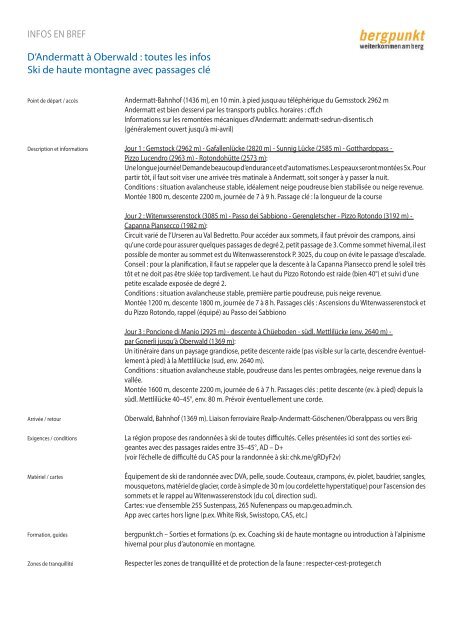
Proposition de Course 03.2024 - Ski de haute montagne avec passages clé

Create successful ePaper yourself
Turn your PDF publications into a flip-book with our unique Google optimized e-Paper software.
INFOS EN BREF<br />
D’An<strong>de</strong>rmatt à Oberwald : toutes les infos<br />
<strong>Ski</strong> <strong>de</strong> <strong>haute</strong> <strong>montagne</strong> <strong>avec</strong> <strong>passages</strong> <strong>clé</strong><br />
Point <strong>de</strong> départ / accès<br />
An<strong>de</strong>rmatt-Bahnhof (1436 m), en 10 min. à pied jusqu›au téléphérique du Gemsstock 2962 m<br />
An<strong>de</strong>rmatt est bien <strong>de</strong>sservi par les transports publics. horaires : cff.ch<br />
Informations sur les remontées mécaniques d’An<strong>de</strong>rmatt: an<strong>de</strong>rmatt-sedrun-disentis.ch<br />
(généralement ouvert jusqu’à mi-avril)<br />
Description et informations Jour 1 : Gemstock (2962 m) - Gafallenlücke (2820 m) - Sunnig Lücke (2585 m) - Gotthardppass -<br />
Pizzo Lucendro (2963 m) - Rotondohütte (2573 m):<br />
Une longue journée! Deman<strong>de</strong> beaucoup d’endurance et d’automatismes. Les peaux seront montées 5x. Pour<br />
partir tôt, il faut soit viser une arrivée très matinale à An<strong>de</strong>rmatt, soit songer à y passer la nuit.<br />
Conditions : situation avalancheuse stable, idéalement neige poudreuse bien stabilisée ou neige revenue.<br />
Montée 1800 m, <strong>de</strong>scente 2200 m, journée <strong>de</strong> 7 à 9 h. Passage <strong>clé</strong> : la longueur <strong>de</strong> la course<br />
Jour 2 : Witenwsserenstock (3085 m) - Passo <strong>de</strong>i Sabbiono - Gerengletscher - Pizzo Rotondo (3192 m) -<br />
Capanna Piansecco (1982 m):<br />
Circuit varié <strong>de</strong> l’Urseren au Val Bedretto. Pour accé<strong>de</strong>r aux sommets, il faut prévoir <strong>de</strong>s crampons, ainsi<br />
qu’une cor<strong>de</strong> pour assurer quelques <strong>passages</strong> <strong>de</strong> <strong>de</strong>gré 2, petit passage <strong>de</strong> 3. Comme sommet hivernal, il est<br />
possible <strong>de</strong> monter au sommet est du Witenwasserenstock P. 3025, du coup on évite le passage d’escala<strong>de</strong>.<br />
Conseil : pour la planification, il faut se rappeler que la <strong>de</strong>scente à la Capanna Piansecco prend le soleil très<br />
tôt et ne doit pas être skiée top tardivement. Le haut du Pizzo Rotondo est rai<strong>de</strong> (bien 40°) et suivi d’une<br />
petite escala<strong>de</strong> exposée <strong>de</strong> <strong>de</strong>gré 2.<br />
Conditions : situation avalancheuse stable, première partie poudreuse, puis neige revenue.<br />
Montée 1200 m, <strong>de</strong>scente 1800 m, journée <strong>de</strong> 7 à 8 h. Passages <strong>clé</strong>s : Ascensions du Witenwasserenstock et<br />
du Pizzo Rotondo, rappel (équipé) au Passo <strong>de</strong>i Sabbiono<br />
Jour 3 : Poncione di Manio (2925 m) - <strong>de</strong>scente à Chüebo<strong>de</strong>n - südl. Mettlilücke (env. 2640 m) -<br />
par Gonerli jusqu’à Oberwald (1369 m):<br />
Un itinéraire dans un paysage grandiose, petite <strong>de</strong>scente rai<strong>de</strong> (pas visible sur la carte, <strong>de</strong>scendre éventuellement<br />
à pied) à la Mettlilücke (sud, env. 2640 m).<br />
Conditions : situation avalancheuse stable, poudreuse dans les pentes ombragées, neige revenue dans la<br />
vallée.<br />
Montée 1600 m, <strong>de</strong>scente 2200 m, journée <strong>de</strong> 6 à 7 h. Passages <strong>clé</strong>s : petite <strong>de</strong>scente (ev. à pied) <strong>de</strong>puis la<br />
südl. Mettlilücke 40–45°, env. 80 m. Prévoir éventuellement une cor<strong>de</strong>.<br />
Arrivée / retour<br />
Exigences / conditions<br />
Matériel / cartes<br />
Formation, gui<strong>de</strong>s<br />
Zones <strong>de</strong> tranquillité<br />
Oberwald, Bahnhof (1369 m). Liaison ferroviaire Realp-An<strong>de</strong>rmatt-Göschenen/Oberalppass ou vers Brig<br />
La région propose <strong>de</strong>s randonnées à ski <strong>de</strong> toutes difficultés. Celles présentées ici sont <strong>de</strong>s sorties exigeantes<br />
<strong>avec</strong> <strong>de</strong>s <strong>passages</strong> rai<strong>de</strong>s entre 35–45°, AD – D+<br />
(voir l’échelle <strong>de</strong> difficulté du CAS pour la randonnée à ski: chk.me/gRDyF2v)<br />
Équipement <strong>de</strong> ski <strong>de</strong> randonnée <strong>avec</strong> DVA, pelle, sou<strong>de</strong>. Couteaux, crampons, év. piolet, baudrier, sangles,<br />
mousquetons, matériel <strong>de</strong> glacier, cor<strong>de</strong> à simple <strong>de</strong> 30 m (ou cor<strong>de</strong>lette hyperstatique) pour l’ascension <strong>de</strong>s<br />
sommets et le rappel au Witenwasserenstock (du col, direction sud).<br />
Cartes: vue d’ensemble 255 Sustenpass, 265 Nufenenpass ou map.geo.admin.ch.<br />
App <strong>avec</strong> cartes hors ligne (p.ex. White Risk, Swisstopo, CAS, etc.)<br />
bergpunkt.ch – Sorties et formations (p. ex. Coaching ski <strong>de</strong> <strong>haute</strong> <strong>montagne</strong> ou introduction à l’alpinisme<br />
hivernal pour plus d’autonomie en <strong>montagne</strong>.<br />
Respecter les zones <strong>de</strong> tranquillité et <strong>de</strong> protection <strong>de</strong> la faune : respecter-cest-proteger.ch