Eaux de Surface - Rio Tinto Simandou
Eaux de Surface - Rio Tinto Simandou
Eaux de Surface - Rio Tinto Simandou

You also want an ePaper? Increase the reach of your titles
YUMPU automatically turns print PDFs into web optimized ePapers that Google loves.
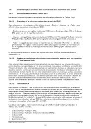
8°40'0"N<br />
8°30'0"N<br />
970000<br />
960000<br />
950000<br />
Kakano<br />
940000<br />
930000<br />
Vassaou<br />
Bonodou<br />
Fassinédou<br />
Famoila<br />
Légen<strong>de</strong>:<br />
Sites d'échantillonnage <strong>de</strong>s sédiments /<br />
Sediment Sampling Locations<br />
Automatique / Automatic<br />
Point / Spot<br />
Haute altitu<strong>de</strong>s / Highest Elevation<br />
9°0'0"W<br />
Kamiandou<br />
500000<br />
Sossava<br />
500000<br />
9°0'0"W<br />
Contour <strong>de</strong> mine / Mine Outline<br />
Terril <strong>de</strong> stériles / Waste Emplacement<br />
Agglomération / Settlement<br />
Bassin versant / Catchment<br />
Bassin versant du Niger / Niger Watershed<br />
Mandou<br />
Banko<br />
Korèla<br />
Touréla<br />
Orono<br />
Route principale / Primary Road<br />
Route secondaire / Secondary Road<br />
Route tertiaire / Tertiary Route<br />
Cours d'eau principal /<br />
Primary Watercourse<br />
Drainage possibles /<br />
Possible Drainage<br />
Trajectoire <strong>de</strong>s sediments /<br />
Stream Sediment Path<br />
Inférée / Inferred<br />
Observées / Observed<br />
Pas <strong>de</strong> sédiments /<br />
No Sediment<br />
Kamandou<br />
Mamouroudou<br />
510000<br />
Traoréla<br />
Lamandou<br />
510000<br />
Sibiridou<br />
Pic <strong>de</strong> Fon<br />
(1656m)<br />
Bangalydou<br />
N.1<br />
Pic du<br />
Oueleba<br />
(1330m)<br />
Siatouro<br />
Canga<br />
East<br />
Camp<br />
Gbagbadou<br />
Wataférédou II<br />
CLIENT: Taille: Titre:<br />
A4<br />
0 5<br />
kilomètres<br />
PROJECTION: WGS 1984 UTM Zone 29N<br />
8°50'0"W<br />
N.1<br />
Moribadou<br />
Foma<br />
G u iin n e a --B B iis s s a u<br />
8°50'0"W<br />
520000<br />
Nionsomoridou<br />
520000<br />
Figure 6A.10<br />
Wataférédou I<br />
Kankoro<br />
S e n e g a ll<br />
N.1<br />
Kouwandala<br />
Soumailadou<br />
Boulaydou<br />
Mafindou<br />
Kissiboula<br />
Bobaro<br />
Koimoridou<br />
Domanidou<br />
Flux affectés par le ruissellement <strong>de</strong>s<br />
sédiments dans le zone minière /<br />
Streams Affected by Sediment<br />
Runoff in Mining Area<br />
Date: 06/06/2012<br />
Dessiné par: WB<br />
G u i n e a<br />
S ii e r r a<br />
L e o n e<br />
Vérifié par: TS<br />
L iib b e r iia a<br />
Approuvé par: KR<br />
M a llii Projet: 0131299<br />
970000<br />
960000<br />
Thia<br />
950000<br />
940000<br />
930000<br />
8°40'0"N<br />
8°30'0"N<br />
Echelle: Comme barre d'échelle<br />
File: 0131299<strong>Simandou</strong>GIS_IG_CK\Maps\ERM\Hydrology\Mine\May2012_revisions\Annex_6A\mi_sediment_affected_streams.mxd