

Implementation Of GIS MyGDI - Malaysia Geoportal
Implementation Of GIS MyGDI - Malaysia Geoportal
Implementation Of GIS MyGDI - Malaysia Geoportal

Create successful ePaper yourself
Turn your PDF publications into a flip-book with our unique Google optimized e-Paper software.
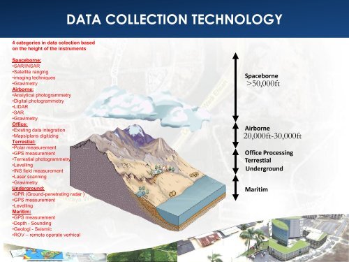
DATA COLLECTION TECHNOLOGY<br />
4 categories in data colection based<br />
on the height of the instruments<br />
Spaceborne:<br />
•SAR/INSAR<br />
•Satellite ranging<br />
•imaging techniques<br />
•Gravimetry<br />
Airborne:<br />
•Analytical photogrammetry<br />
•Digital photogrammetry<br />
•LIDAR<br />
•SAR<br />
•Gravimetry<br />
<strong>Of</strong>fice:<br />
•Existing data integration<br />
•Maps/plans digitizing<br />
Terrestial:<br />
•Polar measurement<br />
•GPS measurement<br />
•Terrestial photogrammetry<br />
•Levelling<br />
•INS field measurement<br />
•Laser scanning<br />
•Gravimetry<br />
Underground:<br />
•GPR (Ground-penetrating radar )<br />
•GPS measurement<br />
•Levelling<br />
Maritim:<br />
•GPS measurement<br />
•Depth - Sounding<br />
•Geologi - Seismic<br />
•ROV – remote operate verhical<br />
Spaceborne<br />
>50,000ft<br />
Airborne<br />
20,000ft-30,000ft<br />
<strong>Of</strong>fice Processing<br />
Terrestial<br />
Underground<br />
Maritim


