

Implementation Of GIS MyGDI - Malaysia Geoportal
Implementation Of GIS MyGDI - Malaysia Geoportal
Implementation Of GIS MyGDI - Malaysia Geoportal

You also want an ePaper? Increase the reach of your titles
YUMPU automatically turns print PDFs into web optimized ePapers that Google loves.
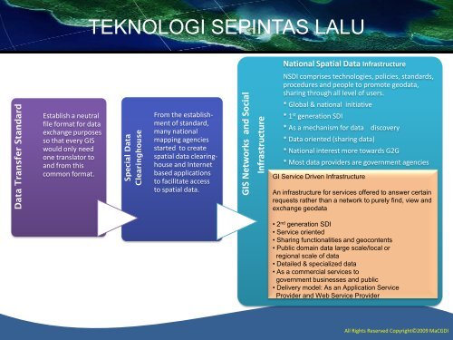
Data Transfer Standard<br />
Special Data<br />
Clearinghouse<br />
<strong>GIS</strong> Networks and Social<br />
Infrastructure<br />
TEKNOLOGI SEPINTAS LALU<br />
National Spatial Data Infrastructure<br />
NSDI comprises technologies, policies, standards,<br />
procedures and people to promote geodata,<br />
sharing through all level of users.<br />
Establish a neutral<br />
file format for data<br />
exchange purposes<br />
so that every <strong>GIS</strong><br />
would only need<br />
one translator to<br />
and from this<br />
common format.<br />
From the establishment<br />
of standard,<br />
many national<br />
mapping agencies<br />
started to create<br />
spatial data clearinghouse<br />
and Internet<br />
based applications<br />
to facilitate access<br />
to spatial data.<br />
* Global & national initiative<br />
* 1 st generation SDI<br />
* As a mechanism for data discovery<br />
* Data oriented (sharing data)<br />
* National interest more towards G2G<br />
* Most data providers are government agencies<br />
GI Service Driven Infrastructure<br />
An infrastructure for services offered to answer certain<br />
requests rather than a network to purely find, view and<br />
exchange geodata<br />
• 2 nd generation SDI<br />
• Service oriented<br />
• Sharing functionalities and geocontents<br />
• Public domain data large scale/local or<br />
regional scale of data<br />
• Detailed & specialized data<br />
• As a commercial services to<br />
government businesses and public<br />
• Delivery model: As an Application Service<br />
Provider and Web Service Provider<br />
All Rights Reserved Copyright©2009 MaCGDI


