Distribution of marine, benthic macro-organisms at Svalbard ...
Distribution of marine, benthic macro-organisms at Svalbard ...
Distribution of marine, benthic macro-organisms at Svalbard ...

You also want an ePaper? Increase the reach of your titles
YUMPU automatically turns print PDFs into web optimized ePapers that Google loves.
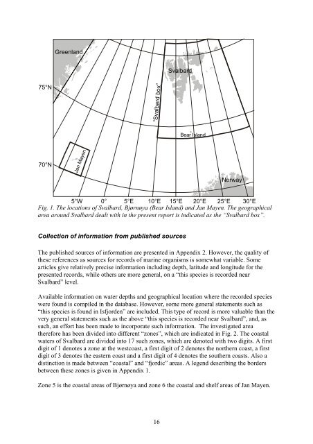
75°N<br />
70°N<br />
Greenland<br />
Jan Mayen<br />
“<strong>Svalbard</strong> box”<br />
5°W 0° 5°E 10°E 15°E 20°E 25°E 30°E<br />
Fig. 1. The loc<strong>at</strong>ions <strong>of</strong> <strong>Svalbard</strong>, Bjørnøya (Bear Island) and Jan Mayen. The geographical<br />
area around <strong>Svalbard</strong> dealt with in the present report is indic<strong>at</strong>ed as the “<strong>Svalbard</strong> box”.<br />
16<br />
<strong>Svalbard</strong><br />
Collection <strong>of</strong> inform<strong>at</strong>ion from published sources<br />
Bear Island<br />
Norway<br />
The published sources <strong>of</strong> inform<strong>at</strong>ion are presented in Appendix 2. However, the quality <strong>of</strong><br />
these references as sources for records <strong>of</strong> <strong>marine</strong> <strong>organisms</strong> is somewh<strong>at</strong> variable. Some<br />
articles give rel<strong>at</strong>ively precise inform<strong>at</strong>ion including depth, l<strong>at</strong>itude and longitude for the<br />
presented records, while others are more general, on a “this species is recorded near<br />
<strong>Svalbard</strong>” level.<br />
Available inform<strong>at</strong>ion on w<strong>at</strong>er depths and geographical loc<strong>at</strong>ion where the recorded species<br />
were found is compiled in the d<strong>at</strong>abase. However, some more general st<strong>at</strong>ements such as<br />
“this species is found in Isfjorden” are included. This type <strong>of</strong> record is more valuable than the<br />
very general st<strong>at</strong>ements such as the above “this species is recorded near <strong>Svalbard</strong>”, and, as<br />
such, an effort has been made to incorpor<strong>at</strong>e such inform<strong>at</strong>ion. The investig<strong>at</strong>ed area<br />
therefore has been divided into different “zones”, which are indic<strong>at</strong>ed in Fig. 2. The coastal<br />
w<strong>at</strong>ers <strong>of</strong> <strong>Svalbard</strong> are divided into 17 such zones, which are denoted with two digits. A first<br />
digit <strong>of</strong> 1 denotes a zone <strong>at</strong> the westcoast, a first digit <strong>of</strong> 2 denotes the northern coast, a first<br />
digit <strong>of</strong> 3 denotes the eastern coast and a first digit <strong>of</strong> 4 denotes the southern coasts. Also a<br />
distinction is made between “coastal” and “fjordic” areas. A legend describing the borders<br />
between these zones is given in Appendix 1.<br />
Zone 5 is the coastal areas <strong>of</strong> Bjørnøya and zone 6 the coastal and shelf areas <strong>of</strong> Jan Mayen.