

“cASTELLI PATRIARCALI FRA FRIULI E SLOVENIA” A ... - Giro FVG
“cASTELLI PATRIARCALI FRA FRIULI E SLOVENIA” A ... - Giro FVG
“cASTELLI PATRIARCALI FRA FRIULI E SLOVENIA” A ... - Giro FVG
- TAGS
- patriarcali
- friuli
- giro
- girofvg.com

You also want an ePaper? Increase the reach of your titles
YUMPU automatically turns print PDFs into web optimized ePapers that Google loves.
40<br />
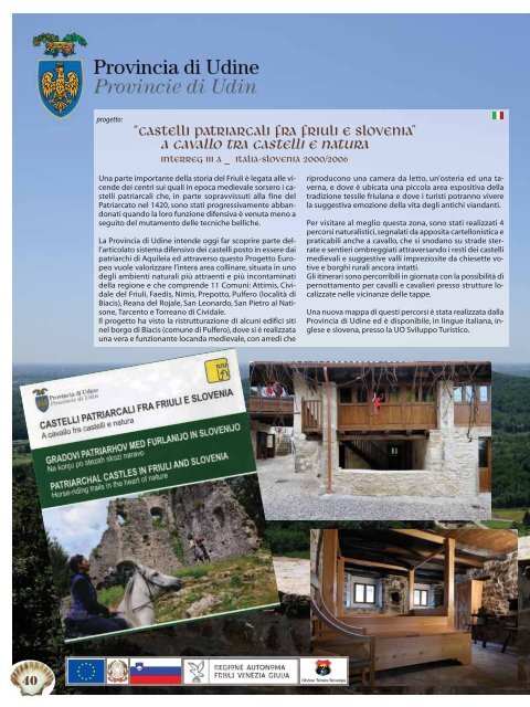
progetto:<br />
<strong>“cASTELLI</strong> <strong>PATRIARCALI</strong> <strong>FRA</strong> <strong>FRIULI</strong> E <strong>SLOVENIA”</strong><br />
A CAVALLO TRA CASTELLI E NATURA<br />
INTERREG III A _ ITALIA-SLOVENIA 2000/2006<br />
Una parte importante della storia del Friuli è legata alle vicende<br />
dei centri sui quali in epoca medievale sorsero i castelli<br />
patriarcali che, in parte sopravvissuti alla fine del<br />
Patriarcato nel 1420, sono stati progressivamente abbandonati<br />
quando la loro funzione difensiva è venuta meno a<br />
seguito del mutamento delle tecniche belliche.<br />
La Provincia di Udine intende oggi far scoprire parte dell’articolato<br />
sistema difensivo dei castelli posto in essere dai<br />
patriarchi di Aquileia ed attraverso questo Progetto Europeo<br />
vuole valorizzare l’intera area collinare, situata in uno<br />
degli ambienti naturali più attraenti e più incontaminati<br />
della regione e che comprende 11 Comuni: Attimis, Cividale<br />
del Friuli, Faedis, Nimis, Prepotto, Pulfero (località di<br />
Biacis), Reana del Rojale, San Leonardo, San Pietro al Natisone,<br />
Tarcento e Torreano di Cividale.<br />
Il progetto ha visto la ristrutturazione di alcuni edifici siti<br />
nel borgo di Biacis (comune di Pulfero), dove si è realizzata<br />
una vera e funzionante locanda medievale, con arredi che<br />
riproducono una camera da letto, un’osteria ed una taverna,<br />
e dove è ubicata una piccola area espositiva della<br />
tradizione tessile friulana e dove i turisti potranno vivere<br />
la suggestiva emozione della vita degli antichi viandanti.<br />
Per visitare al meglio questa zona, sono stati realizzati 4<br />
percorsi naturalistici, segnalati da apposita cartellonistica e<br />
praticabili anche a cavallo, che si snodano su strade sterrate<br />
e sentieri ombreggiati attraversando i resti dei castelli<br />
medievali e suggestive valli impreziosite da chiesette votive<br />
e borghi rurali ancora intatti.<br />
Gli itinerari sono percorribili in giornata con la possibilità di<br />
pernottamento per cavalli e cavalieri presso strutture localizzate<br />
nelle vicinanze delle tappe.<br />
Una nuova mappa di questi percorsi è stata realizzata dalla<br />
Provincia di Udine ed è disponibile, in lingue italiana, inglese<br />
e slovena, presso la UO Sviluppo Turistico.
projekt:<br />
„PATRIARCHENBURGEN<br />
IN FRIAUL UND SLOWENIEN“<br />
ZWISCHEN BURGEN UND NATUR<br />
INTERREG III A _ Italien - Slowenien 2000/2006<br />
In der Geschichte des Friaul kommt<br />
den Ereignissen an jenen Orten, wo<br />
im Mittelalter die Patriarchatsburgen<br />
standen, eine wichtige Bedeutung<br />
zu. Einige dieser Burgen überlebten<br />
das Ende des Patriarchats im Jahr<br />
1420, wurden jedoch nach und nach<br />
verlassen, als ihre Verteidigungsfunktionen<br />
aufgrund der neuen Kriegsführungstechniken<br />
unbedeutend<br />
wurden.<br />
Die Provinz Udine hat das Anliegen,<br />
einen Teil dieses ausgedehnten Burgenverteidigungssystems<br />
der Patriarchen<br />
von Aquileia bekannt zu<br />
machen. Im Rahmen dieses Europäischen<br />
Projektes soll das gesamte Hügelgebiet<br />
mit seiner Naturlandschaft,<br />
die eine der attraktivsten und ursprünglichsten<br />
der Region ist, aufgewertet<br />
werden. Es umfasst 11<br />
Gemeinden: Attimis, Cividale del<br />
Friuli, Faedis, Nimis, Prepotto, Pulfero<br />
(Ortsteil Biacis), Reana del Rojale, San<br />
Leonardo, San Pietro al Natisone, Tarcento<br />
und Torreano di Cividale.<br />
Im Zuge des Projektes wurden einige<br />
Gebäude im Ortsteil Biacis (Gemeinde<br />
Pulfero) restauriert, wo ein<br />
echter und funktionierender mittelalterlicher<br />
Gasthof mit Schlafzimmer,<br />
Wirtshaus und Taverne aus der<br />
damaligen Zeit nachgebildet wurde.<br />
Außerdem wurde ein kleiner Aus-<br />
project:<br />
stellungsraum über das traditionelle<br />
Webhandwerk im Friaul eingerichtet.<br />
Die Besucher können somit einen interessanten<br />
Einblick in das Leben der<br />
Reisenden in früheren Zeiten erhalten.<br />
Um die Gegend intensiver kennen<br />
zu lernen, wurden vier gekennzeichnete<br />
Naturstrecken eingerichtet,<br />
die auch mit dem Pferd beritten werden<br />
können. Sie führen über Feldwege<br />
und schattige Pfade, vorbei<br />
an mittelalterlichen Burgruinen und<br />
durch eindrucksvolle Täler, in denen<br />
Votivkirchen und heute noch intakte<br />
Bauerndörfer stehen.<br />
Die Etappen können an einem Tag<br />
zurückgelegt werden, mit Übernachtungsmöglichkeiten<br />
für Pferde<br />
und Reiter in nahe gelegenen Unterkünften.<br />
Die Provinz Udine hat eine neue<br />
Karte mit den genannten Naturwegen<br />
herausgegeben, die in italienischer,<br />
englischer und slowenischer<br />
Sprache im Büro für Tourismusentwicklung<br />
(UO Sviluppo Turistico) erhältlich<br />
sind.<br />
“PATRIARCHAL CASTLES BETWEEN <strong>FRIULI</strong> AND <strong>SLOVENIA”</strong><br />
HORSE RIDING THROUGH NATURE AND CASTLES<br />
INTERREG III A _ Italy – Slovenia 2000/2006<br />
An important part of the history of Friuli Venezia Giulia refers to the<br />
events that took place in the towns and villages where patriarchal castles<br />
were erected in the Middle Ages. The castles partly survived the<br />
end of the Patriarchate in 1420 and were abandoned progressively<br />
when, due to changed war techniques, their defensive function became<br />
obsolete.<br />
The intention of the Udine Province is to disclose partly of the articulate<br />
defence system of castles set up by the patriarchs of Aquileia and,<br />
by means of this European Project, revaluate the entire hilly territory,<br />
set in one of the most attractive and pristine areas of the region and<br />
spreading over 11 Communes: Attimis, Cividale del Friuli, Faedis, Nimis,<br />
Prepotto, Pulfero (Biacis), Reana del Rojale, San Leonardo, San Pietro al<br />
Natisone, Tarcento and Torreano di Cividale.<br />
The project has involved the renovation of several buildings in Biacis<br />
(Pulfero), where a real working inn featuring a medieval bedroom and<br />
a tavern has been created together with a small exhibition area sho-<br />
wing the old traditional weaving heritage of Friuli and where visitors<br />
can experience the life of the ancient wayfarers.<br />
To enjoy the best views of this natural area, there are 4 different routes,<br />
accessible by horse riders and marked by specific road signs,<br />
which include tracks, shady paths leading from one medieval castle to<br />
another, through attractive valleys spotted by votive chapels and pristine<br />
rural hamlets.<br />
The routes can be completed in one day and in the vicinities there<br />
are several accommodation facilities for both horses and riders.<br />
A new map of the routes in Italian, English and Slovenian, issued by<br />
the Udine Province, is available at the Tourist Office (UO Sviluppo Turistico).<br />
41
Grado, l’Isola del Sole. Un’isola incastonata<br />
in una laguna che costituisce<br />
una realtà naturale e paesaggistica autonoma,<br />
che gode di un microclima davvero<br />
unico e le cui acque hanno ottime<br />
qualità talassoterapiche.<br />
Ma anche una variopinta cittadina sorta<br />
sulla sabbia e il cui centro storico è un dedalo<br />
di calli, campi e campielli in cui si custodiscono<br />
cultura, arte e tradizioni<br />
emancipate dal resto del Friuli Venezia<br />
Giulia, ma ad esso indissolubilmente legate.<br />
Le vicende storiche hanno legato e diviso<br />
Grado dall’entroterra Friulano e Goriziano:<br />
il grande porto marino romano<br />
crebbe d’importanza quando le popolazioni<br />
della terra ferma si rifugiarono sull’isola<br />
per difendersi dalle invasioni<br />
barbariche; la sede vescovile spostata da<br />
Aquileia a Grado creò il dualismo tra le<br />
due città e dopo il trasferimento del patriarcato<br />
a Venezia, Grado venne quasi<br />
cinta d'assedio dalle popolazioni della<br />
terraferma.<br />
Grado, die Sonneninsel. Eine Insel inmitten<br />
einer Lagune, die eine Naturlandschaft<br />
an sich bildet, mit einzigartigem<br />
Mikroklima und einem Wasser, das hervorragende<br />
thalassotherapeutische Eigenschaften<br />
aufweist.<br />
Ein lebendiges Städtchen, das auf sandigem<br />
Untergrund errichtet wurde und<br />
dessen Altstadt aus einem Labyrinth von<br />
Gässchen, sowie großen und kleinen<br />
Plätzen voller Kultur, Kunst und Traditionen<br />
besteht, die sich vom übrigen<br />
Friaul-Julisch Venetien abheben und<br />
doch unauflöslich mit ihm verbunden<br />
sind.<br />
Im Laufe der geschichtlichen Ereignisse<br />
war Grado abwechselnd mit dem Hinterland<br />
des Friauls und dem von Görz verbunden<br />
oder von diesen getrennt: der<br />
große römische Seehafen gewann an<br />
Bedeutung, als die Bevölkerung des Festlandes<br />
auf die Insel flüchtete, um sich<br />
vor den Barbareneinfällen zu schützen;<br />
nach Verlegung des Bischofssitzes von<br />
Aquileia nach Grado traten die beiden<br />
Grado, the Golden Island. This island<br />
set amidst the lagoon constitutes a very<br />
special environment of great natural and<br />
landscape value; it enjoys a microclimate,<br />
which is really unique and its seawater<br />
possesses exceptional<br />
thalasso-theurapeutic qualities.<br />
The lively town, which developed on the<br />
sand and whose old town is a maze of alleys,<br />
squares and places, known as calli,<br />
campi and campielli, enshrines culture,<br />
art and customs that are free from the<br />
tradition of Friuli but are nevertheless indissolubly<br />
bound to it.<br />
The historical events have unified and yet<br />
divided Grado form the inland parts of<br />
Friuli and the area included under Gorizia:<br />
the large Roman port grew in status<br />
and importance when the populations of<br />
the mainland found shelter there after<br />
escaping the Barbaric invasions; the Episcopal<br />
see being moved from Aquileia to<br />
Grado gave rise to a dualism between the<br />
two towns and when the Patriarchate<br />
was transferred to Venice, Grado was ne-<br />
di Giusy Mancini<br />
43
44<br />
Dopo il dominio della Serenissima<br />
di Venezia e quello francese,<br />
il passaggio all’Austria fece<br />
vivere a Grado un nuovo periodo<br />
di prosperità: divenne un'esclusiva<br />
località termale frequentata<br />
dagli aristocratici della monarchia<br />
austro-ungarica.<br />
Il passaggio all’Italia alla fine<br />
della prima guerra mondiale,<br />
non ha fatto smettere la cittadina<br />
di vivere di ricordi sempre<br />
più sfumati, ma continuando a<br />
mantenere vivo il proprio retaggio<br />
linguistico: dall’isolamento di<br />
Grado dettato dagli eventi storici<br />
deriva infatti la sopravvivenza<br />
del dialetto gradese, un dialetto<br />
medievale arcaico che ha resistito<br />
al tempo ed al quale è stata<br />
data la dignità di lingua dal<br />
grande poeta Biagio Marin.<br />
foto di Laura Marocco © 2008<br />
Städte in Konkurrenz zueinander. Als<br />
das Patriarchat nach Venedig zog, wurde<br />
Grado von den Bevölkerungen vom Festland<br />
fast belagert.<br />
Nach der venezianischen und französischen<br />
Herrschaft erlebte Grado mit der<br />
Übernahme durch Österreich eine neue<br />
Blütezeit: es entwickelte sich zu einem<br />
exklusiven Kurort der Aristokratie der<br />
österreichisch-ungarischen Monarchie.<br />
Nach dem Ende des Ersten Weltkrieges<br />
kam das Städtchen zu Italien, wobei die<br />
Erinnerungen an die vergangenen Ereignisse,<br />
wenn auch in abgeschwächter<br />
Form, stets weiterleben. Lebendig geblieben<br />
ist auch ein sprachliches Vermächtnis:<br />
aufgrund der Isolierung Grados<br />
im Laufe der Geschichte hat sich hier ein<br />
archaischer, mittelalterlicher Dialekt erhalten,<br />
der den Zeiten getrotzt hat und<br />
von dem großen Dichter Biagio Marin zu<br />
einer eigenen Sprache erhoben wurde.<br />
arly besieged by the populations<br />
of the mainland. Following<br />
the end of the domination by the<br />
Venetian Serenissima and that of<br />
the French, Grado became Austrian<br />
and enjoyed a new period<br />
of prosperity: it became an exclusive<br />
thermal resort, most frequented<br />
by the Austro-Hungarian<br />
aristocracy. Despite becoming Italian<br />
after the First World War,<br />
Grado has never stopped indulging<br />
in ever fading memories and<br />
has maintained its unique linguistic<br />
heritage: it is because of the<br />
isolation the town experienced<br />
due to its historical events that the<br />
unique dialect of Grado, an archaic<br />
medieval idiom, has resisted time<br />
and was promoted to the status of<br />
language thanks to the great poet<br />
Biagio Marin.
foto Flash Grado © 2009<br />
TRA STORIA ED ARTE<br />
Il centro storico di Grado è un dedalo di calli,<br />
campi e campielli in cui le testimonianze architettoniche<br />
ci ricordano l'origine romana<br />
della città ed il periodo in cui Grado fu sede<br />
patriarcale e si fondono con l'aspetto pittoresco<br />
della sua architettura spontanea.<br />
Il centro storico è insediato per la maggior<br />
parte sull’area dell’antico “castrum” romano:<br />
il primo nucleo urbano fortificato di forma<br />
stretta e affusolata, sviluppatosi in età imperiale<br />
come parte estrema del sistema portuale<br />
aquileiese.<br />
ZWISCHEN GESCHICHTE UND<br />
KUNST<br />
Die Altstadt Grados besteht aus einem Gewirr<br />
von Gässchen, sowie großen und kleinen<br />
Plätzen mit architektonischen Zeugnissen<br />
aus der Zeit des Römischen Reiches und des<br />
Patriarchats, die gemeinsam mit den spontan<br />
entstandenen Bauten eine malerische Atmosphäre<br />
entstehen lassen.<br />
Die Altstadt liegt größtenteils auf dem Gebiet<br />
des antiken, römischen „Castrum“. Diese erste<br />
befestigte Ansiedlung von schmaler, lang gezogener<br />
Form entwickelte sich während der<br />
Kaiserzeit als äußerster Teil der Hafenanlage<br />
AMIDST HISTORY AND ART<br />
The old town of Grado is a maze of alleys,<br />
squares and places, known as calli, campi and<br />
campielli, where the many architectural features<br />
remind us of the Roman origin of the town<br />
and of a time in which Grado was the Episcopal<br />
seat, as well as exquisitely mingle with the<br />
picturesque spontaneous architecture. Most<br />
of the old town was built on the ruins of the<br />
ancient roman castrum: the first fortified<br />
urban area with its long and narrow layout, developed<br />
during the Imperial Age as the extreme<br />
end of the port system of Aquileia.<br />
Al centro dell'antico "castrum", in Campo dei<br />
Patriarchi, si ergono tre mirabili edifici paleocristiani<br />
in cui brillano le tessere di preziosi<br />
mosaici: la Basilica di S. Eufemia (il Duomo),<br />
il Battistero a struttura ottagonale e la Basilica<br />
di Santa Maria delle Grazie.<br />
Questi importanti edifici sacri, assieme ai resti<br />
di un'altra grande basilica e di un battistero<br />
sotto il suolo dell'odierna piazza della Vittoria<br />
sono le testimonianze della presenza a<br />
Grado del vescovo e dei presbiteri di Aquileia<br />
rifugiatisi qui in seguito alle invasioni longobarde.<br />
von Aquileia.<br />
In Zentrum des antiken „Castrum“, auf dem<br />
Campo dei Patriarchi, erheben sich drei wunderschöne<br />
frühchristliche Bauten, die wertvolle<br />
Mosaiken enthalten: die Basilika S.<br />
Eufemia (der Dom), das achteckige Baptisterium<br />
und die Basilika Santa Maria delle<br />
Grazie.<br />
Diese bedeutenden Sakralbauten zeugen,<br />
gemeinsam mit den Resten einer weiteren<br />
Basilika und eines Baptisteriums unter der<br />
heutigen Piazza della Vittoria, vom Aufenthalt<br />
des Bischofs und der Presbyter von Aquileia,<br />
die hier vor den langobardischen Einfällen<br />
Zuflucht fanden.<br />
In the centre of the castrum, the Campo dei<br />
Patriarchi, the square of the Patriarchs where<br />
three marvellous Paleochristian buildings enshrine<br />
important parts of precious mosaics:<br />
the Basilica of S. Eufemia (the Cathedral), the<br />
octagonal-shaped Baptistery and the Basilica<br />
of Santa Maria delle Grazie (Saint Mary of<br />
Graces).<br />
These important scared buildings together<br />
with the ruins of another large basilica and a<br />
baptistery today below the surface of Piazza<br />
della Vittoria are the evidence of the presence<br />
of the Bishop and the presbyterate, who had<br />
found shelter in Grado during the invasion of<br />
the Longobards.<br />
45
46<br />
La basilica di Sant'Eufemia risale al VI secolo ed<br />
è affiancata dal battistero e dal campanile a cuspide,<br />
d’aspetto veneziano, del XV secolo.<br />
Questa basilica fu dedicata a Sant’Eufemia dal Patriarca<br />
Elia e sorge sopra i resti di un'antica basilica<br />
del IV secolo.<br />
Si tratta di una basilica a tre navate, delimitate da due<br />
file di dieci colonne in marmo policromo, sormontate<br />
da capitelli di varia epoca e provenienza.<br />
Il grande mosaico pavimentale, risalente alla fine del<br />
VI secolo, è di notevole importanza.<br />
La basilica ospita la statua della Madonna degli Angeli<br />
che, in occasione della festa del Perdon di Barbana<br />
(prima domenica di luglio), viene portata in<br />
processione in laguna fino al santuario di Barbana.<br />
Connesso al complesso basilicale c’è il battistero,<br />
dove si trova un’ampia vasca ottagonale marmorea<br />
a immersione circondata dal pavimento mosaicato.<br />
A nord del battistero, si trova la basilica di Santa<br />
Maria delle Grazie, edificata alla fine del VI secolo<br />
per volontà del Patriarca Elia sul sito di una precente<br />
basilica paleocristiana della prima metà del V secolo.<br />
Con base quadrata sia nella pianta che nell'alzato,<br />
l'interno è diviso in tre navate. Qui è custodita la statua<br />
lignea della Madonna delle Grazie, tradizionale<br />
meta devozionale della popolazione gradese.<br />
Die Basilika Sant'Eufemia geht auf<br />
das 6. Jh. zurück und wird vom Baptisterium<br />
und einem spitzen Glockenturm im<br />
venezianischen Stil aus dem 15. Jh. umrahmt.<br />
Sie wurde vom Patriarchen Elia der Hl. Euphemia<br />
geweiht und steht auf den Resten<br />
einer früheren Basilika aus dem 4. Jh.<br />
Die drei Schiffe der Basilika sind durch<br />
zwei Säulenreihen mit jeweils 10 Säulen<br />
aus mehrfarbigem Marmor abgegrenzt,<br />
die Kapitelle aus verschiedenen<br />
Epochen und von unterschiedlicher<br />
Herkunft tragen.<br />
Von großer Bedeutung ist das große<br />
Fußbodenmosaik aus dem Ende des<br />
6. Jhs.<br />
Die Basilika beherbergt die Statue<br />
der Madonna degli Angeli, die anlässlich<br />
des Kirchenfests „Perdon di<br />
Barbana“ (erster Sonntag im Juli) in<br />
einer Prozession auf der Lagune bis<br />
zur Wallfahrtsstätte Barbana gebracht<br />
wird.<br />
Neben der Basilika liegt das Baptisterium<br />
mit einem großen, achteckigen<br />
Taufbecken aus Marmor, das<br />
von einem Mosaikfußboden umgeben<br />
ist.<br />
Nördlich der Taufkirche liegt die Ba-<br />
silika Santa Maria delle Grazie, die der<br />
Patriarch Elia im 6. Jh. am ehemaligen<br />
Standort einer frühchristlichen Basilika<br />
aus der ersten Hälfte des 5. Jhs. errichten<br />
ließ.<br />
Sowohl Grundriss, als auch Mauern sind<br />
quadratischer Form, der Innenraum ist<br />
dreischiffig. In der Kirche wird die Holzstatue<br />
der Madonna delle Grazie aufbewahrt,<br />
die traditionell von den<br />
Bewohnern Grados verehrt wird.
foto Flash Grado © 2009<br />
The basilica of S. Eufemia dates back to the VI century and<br />
next to it there is the Baptistery and a Venetian style pyramidal<br />
cusp bell-tower of the XV century.<br />
This basilica was dedicated to Saint Eufemia by Patriarch Elia and<br />
was erected upon the ruins of an ancient basilica of the IV century.<br />
The basilica consists of a nave and two aisles, delimited by a row of<br />
ten columns made of polychrome marble, surmounted by capitals<br />
of different ages and origin.<br />
The large mosaic pavement, which dates back to the end of the VI<br />
century, is of remarkable importance.<br />
The basilica houses the statue of the Madonna of the Angels,<br />
which, during the Perdon di Barbana, on the first Sunday of July, is<br />
carried in procession on the lagoon to the Sanctuary of Barbana.<br />
Next to the basilica, the Baptistery with its octagonal marble immersion<br />
basin, surrounded by a mosaic floor.<br />
Leaving the Baptistery, to the north there is the Basilica Santa<br />
Maria delle Grazie, built at the end of the VI century, on the site of<br />
the earlier Paleochristian basilica dating back to the first half of<br />
the V century, by order of the Patriarch Elia.<br />
The basilica, square in plan and elevation, is divided in a nave and<br />
three aisles. It enshrines the wooden statue of the Madonna delle<br />
Grazie (Madonna of Graces), traditionally centre of devotion of the<br />
people of Grado.<br />
47
48<br />
LA DIGA<br />
La Diga è una lunga passeggiata<br />
che collega le due principali<br />
spiagge, quella di ponente, chiamata<br />
"Costa Azzurra", e quella di<br />
levante, la cosiddetta "Spiaggia<br />
Nuova". Vi si affacciano costruzioni<br />
recenti e alcuni edifici<br />
d'epoca ben conservati con i<br />
loro bei giardini.<br />
Di recente è stata rinnovata e<br />
ospita eventi e manifestazioni di<br />
vario genere<br />
IL CORAGGIO DEL NUOVO<br />
Il centro storico di Grado è stato travolto<br />
da un'ondata di novità che ha saputo<br />
trasformarlo in uno spazio di coraggiosa<br />
sperimentazione a misura<br />
d'uomo, un abbinamento piuttosto difficile<br />
da realizzare ma in questo caso<br />
perfettamente riuscito. Il restyling urbanistico<br />
ha interessato le zone nevralgiche<br />
dell'antica Gradus, da Viale Regina<br />
Elena a Piazza Biagio Marin, da Piazza<br />
Duca d'Aosta a Via Marina e al Lungomare<br />
Nazario Sauro, più noto come<br />
"Diga", divenuta una passeggiata mozzafiato<br />
in cui colori e materiali si fondono<br />
a creare inaspettate suggestioni.<br />
E' quindi vivamente consigliato "perdersi"<br />
tra i campi e le calli, tra i viali e le<br />
piazze per assaporare le emozioni di cui<br />
solo le realtà traboccanti di storia, cultura<br />
e tradizioni possono renderci par-<br />
tecipi. DER MUT, NEUES ZU WAGEN<br />
Die Altstadt von Grado hat eine Erneuerungswelle<br />
erlebt, die sie zu einem schwie-<br />
THE PROMENADE<br />
The so called "Diga" is a long promenade<br />
connecting the two main<br />
beaches: the western one, called<br />
"Costa Azzurra", and the eastern one,<br />
called "Spiaggia Nuova". Facing onto<br />
it there are some modern buildings<br />
and several excellently preserved old<br />
houses with their beautiful gardens.<br />
The promenade has recently been<br />
restructured and is a perfect setting<br />
for outdoor events.<br />
THE COURAGE TO TRY<br />
The centre of Grado has been involved<br />
in an important wave of innovation<br />
that transformed it into a<br />
people friendly space of courageous<br />
experimentation, a matching difficult<br />
to reach but very well succeeded.<br />
The restructuring took place in the<br />
core areas of the ancient Gradus,<br />
from Viale Regina Elena to Piazza Biagio<br />
Marin, from Piazza Duca d'Aosta<br />
to Via Marina and to the so called<br />
"dam", the seafront Nazario Sauro,<br />
that has been transformed into a beautiful<br />
promenade where colours<br />
and materials mix and create unexpected<br />
suggestions.<br />
For this reason our advice is to stroll<br />
around among calli and campielli,<br />
viali and piazze to taste the emotions<br />
that only places rich of history, culture<br />
and traditions can give.<br />
DER DAMM<br />
Die sogenannte "Diga" ist ein langer Spazierweg,<br />
welcher die beiden Hauptstrände<br />
von Grado verbindent: den westlichen, genannt<br />
"Costa Azzurra", und den östlichen,<br />
genannt "Spiaggia nuova". Der Weg führt<br />
an einigen modernen Häusern sowie schönen<br />
Gartenanlagen mit alten Gebäuden<br />
vorbei, die gut erhalten und gepflegt sind.<br />
Der vor kurzem neugestaltete Damm ist ein<br />
idealer Ort für Events und Veranstaltungen.<br />
rig zu erzielen jedoch gut gelungenen<br />
menschengerechten Sperimentationsraum<br />
gemacht hat. Das städtebauliche Restyling<br />
betrifft die Kerngebiete des alten Gradus,<br />
von Viale Regina Elena bis Piazza<br />
Biagio Marin, von Piazza Duca d'Aosta biz<br />
Via Marina und zum bekannten "Damm",<br />
und zwar die Promenade Nazario Sauro,<br />
welche mit ihren Farben und Materialien<br />
einen atemberaubenden Blick ermöglicht<br />
und unerwartete Eindrücke schafft.<br />
Es wird deswegen herzlich empfohlen, zwischen<br />
Calli und Campielli, zwischen Viali<br />
und Piazze zu bummeln, um die Gefühle zu<br />
spüren, welche nur die Ortschaften, die<br />
reich an Geschichte, Kultur und Traditionen<br />
sind, ermöglichen.
LA SPIAGGIA<br />
La Bandiera Blu sventola su Grado già da diversi anni, un riconoscimento<br />
prestigioso che certifica la qualità delle acque e la pulizia<br />
della spiaggia.<br />
La caratteristica della spiagge di Grado è quella di essere interamente<br />
rivolte verso sud e di godere della migliore posizione.<br />
La spiaggia di Pineta, la Costa Azzurra e la spiaggia principale si<br />
snodano per diversi chilometri mentre il loro litorale sabbioso degrada<br />
lentamente verso il mare, è un litorale ideale per i bambini:<br />
non a caso Grado è conosciuta per essere il loro paradiso.<br />
Tutte le spiagge sono attrezzate per garantire sia i servizi classici<br />
(sdraio ed ombrellone), sia per offrire chioschi e parchi gioco, fino<br />
al Parco Termale Acquatico, all'animazione e agli sport.<br />
Accanto alla spiaggia principale si estende il grande Parco delle<br />
Rose, che con la sua ombra allevia le giornate più calde, così come<br />
ristoratrice è la pineta a ridosso delle altre spiagge.<br />
DER STRAND<br />
Grado hat bereits zum wiederholten Male die „Bandiera Blu“ erhalten,<br />
eine wichtige Auszeichnung, mit der die Qualität des Wassers<br />
und die Sauberkeit der Strände zertifiziert wird.<br />
Ein charakteristisches Merkmal der Strände von Grado ist die Ausrichtung<br />
nach Süden, sie erfreuen sich also einer hervorragenden<br />
Lage.<br />
Die Strände Pineta, Costa Azzurra und der Hauptstrand erstrecken<br />
über mehrere Kilometer, mit einer langsam im Meer verlaufenden,<br />
sandigen Küste. Der ideale Strand für Kinder: in der Tat ist Grado<br />
bekannt als ein Paradies für die Kleinen.<br />
Alle Strände sind ausgerüstet und bieten sowohl das klassische<br />
Zubehör (Liege und Sonnenschirm), als auch Kioske und Spielplätze,<br />
bis hin zum Thermalwasserpark, Animation und verschiedenen<br />
Sportarten.<br />
Neben dem Hauptstrand liegt der große „Parco delle Rose“, der<br />
an heißen Tagen ebenso Schatten spendet, wie die hinter den anderen<br />
Stränden gelegenen Pinienhaine.<br />
THE BEACH<br />
Grado has been awarded a Blue Flag since quite a few years now,<br />
a prestigious recognition that certifies the quality of the water<br />
and the cleanliness of the beach.<br />
The whole length of the coast running along Grado faces south<br />
enjoying the best of locations.<br />
The Pineta beach, Costa Azzurra and the main beach adjacent the<br />
town run several kilometres along the coast and the sandy beach<br />
slowly degrades towards the water making it an ideal seaside<br />
spot for children: it is not by chance that Grado is considered as<br />
children’s paradise.<br />
All the beaches are fully furnished to offer the most classical services<br />
(deckchairs and beach umbrellas), as well as beach stalls,<br />
playgrounds, the Spa Water Park and beach recreation and sports.<br />
Adjoining the main beach there is the large Parco delle Rose,<br />
which provides shade and quietness even during the hottest days,<br />
as do the pinewoods behind the other beaches.<br />
49
DIE THERMEN<br />
Die Meeres-Thermalbäder Grados<br />
sind mehr als hundertjärigen: in<br />
1892, erklärte Kaiser Franz Joseph<br />
Grado als offiziellen Kurort der<br />
Habsburgischen Monarchie und<br />
den 25. Juni verliehet er die "Meeres-Thermalbäder<br />
der Sonneinsel".<br />
Der geografischen Lage von<br />
Grado ist ein mildes und gemütliches<br />
Mikroklima das ganze Jahr<br />
hindurch zu verdanken.<br />
Die ionisierte Meeresluft und der<br />
Sand, reich an wohltuende Mineralien,<br />
regenerieren den Körper<br />
und den Geist 365 Tage im Jahr.<br />
Neulich ist der Kurort in Grado renoviert<br />
worden und genießt jetzt<br />
eine ganz besondere Lage: befindet<br />
sich in unmittelbarer Meersnähe<br />
und von umgerungen von<br />
Grün und bietet das Thermalbad<br />
eine große Auswahl von Leistungen,<br />
die alle Forderungen erfüllen:<br />
Rehabilitationstherapie, Schönheitspflege<br />
für den Körper, modernste<br />
Wellness- und Fitness- Kuren.<br />
Info: www.gradoit.it<br />
Tel +39 0431 899111<br />
LE TERME DI GRADO<br />
Le Terme Marine di Grado sono ultracentenarie:<br />
nel 1892 l'Imperatore Francesco<br />
Giuseppe riconobbe Grado come<br />
la stazione di cura ufficiale dell'Impero<br />
Asburgico e il 25 giugno le titolò le<br />
"Terme Marine dell'Isola del Sole".<br />
La posizione geografica di Grado regala<br />
nel corso di tutto l'anno un particolare<br />
microclima sempre dolce e gradevole.<br />
L'aria ionizzata del mare e la sabbia ricca<br />
di minerali benefici rigenerano il corpo<br />
e lo spirito 365 giorni all'anno.<br />
Gli stabilimenti termali di Grado godono<br />
di una posizione tutta speciale:<br />
sono immerse nel verde ed ad passo dal<br />
mare e sono addirittura intergrate nella<br />
spiaggia principale ed offrono una<br />
gamma completa di prestazioni per<br />
tutte le esigenze: dalla riabilitazione alle<br />
cure estetiche del corpo, ai trattamenti<br />
wellness e fitness più all'avanguardia.<br />
Info: www.gradoit.it<br />
Tel +39 0431 899111<br />
HEALTH SPA<br />
The Grado Sea Spa Centre are older than a<br />
century: in 1892 the Emperor Francis Joseph<br />
acknowledged Grado as official healt resort<br />
for the Hapsburgh Empire and 25th June he<br />
titled the "Spa Centre of the Sunny Island".<br />
Grado's geographical location offers during<br />
the whole year a mild microclimate: the ionised<br />
seawater and the sand rich in beneficial<br />
minerals reinvigorate the body and the<br />
soul during the whole year.<br />
The Spa of Grado, which has recently been<br />
renovated, enjoys a special geographical position:<br />
is immersed in greenery and really<br />
close to the sea and offers a rich range of services<br />
such as rehabilitation, hydrotherapy,<br />
beauty wellness and fitness treatments.<br />
Info: www.gradoit.it<br />
Tel +39 0431 899111<br />
ORARIO TERME:<br />
tutti i giorni 9.00 - 18.00<br />
PISCINA TERMALE, SAUNA E BAGNO TURCO:<br />
tutti i giorni 10.00 - 20.00<br />
CENTRO ESTETICO:<br />
tutti i giorni 10.00 - 18.30<br />
(accettazione ore 10.00 - 18.00)<br />
FITNESS:<br />
lun-ven 10.00 - 13.00 / 16.00 - 20.00<br />
sabato e domenica 10.00 - 20.00<br />
51
52<br />
IL PARCO TERMALE ACQUATICO<br />
Tra le ricche proposte offerte dall'isola del sole,<br />
Grado vanta anche il Parco Termale Acquatico.<br />
Situato direttamente sulla spiaggia principale<br />
e immerso nel verde, il parco ha una piscina sinuosa<br />
con acqua di mare che si snoda per oltre<br />
85 metri di lunghezza, dotata di idromassaggi e<br />
getti a cascata e attrazioni e giochi per i bambini.<br />
Particolare uno dei bar, con i sedili in acqua.<br />
Il Parco Acquatico è aperto al pubblico di norma<br />
dalla seconda domenica di maggio alla seconda<br />
domenica di settembre di ciascun anno.<br />
Info: www.gradoit.it - tel. +39 0431 899111<br />
DER THERMALWASSERPARK<br />
Unter den zahlreichen Möglichkeiten der Sonneninsel, bietet Grado, direkt<br />
am Hauptstrand, einen angenehmen Thermalwasserpark, umgeben<br />
von üppigem Grün. Der Park hat einen bunten über 85 m langen Meerwasser-Schwimmbad,<br />
verfügt über Unterwassermassagen und Kaskaden<br />
und Attraktionen und Spielen für Kinder.<br />
Ein charakteristischer Kiosk hat Unterwassersitzen.<br />
Der Thermalwasserpark ist normalerweise alljährlich vom 2. Sonntag im<br />
Mai bis zum 2. Sonntag im September geöffnet.<br />
Info: www.gradoit.it - tel. +39 0431 899111<br />
THE THERMAL SEAWATER PARK<br />
Among the wide range of opportunities offered by the Sun Island, Grado<br />
has also a beautiful Thermal Park.<br />
Situated directly on the main beach and surrounded by green and<br />
trees, the park has a sinuous pool, more than 85 meters long, with seawater,<br />
water massages, a cascade and attractions and games for children.<br />
There is also a particular bar, whose seats are "underwater".<br />
The Water Park is open to the public, usually from the second Sunday of<br />
May to the second Sunday of September.<br />
Info: www.gradoit.it - tel. +39 0431 899111
Il Golf Club Grado sorge nelle immediate vicinanze del<br />
campeggio Tenuta Primero e della Marina Primero, in un<br />
ambiente affascinante e incontaminato, immerso nella<br />
laguna. Qui il clima è dolce tutto l'anno.<br />
Ampi greens e larghi fairways sono protetti da essenze<br />
arboree tipiche della zona lagunare.<br />
Annesso al percorso championship e alla driving range<br />
si trova un percorso executive a 9 buche dove i golfisti<br />
possono provare la prima esperienza sul manto erboso.<br />
Il percorso 18 buche, Par 72 SSS 72, di 6.081 metri é fantasioso<br />
e mai ripetitivo.<br />
Tel. +39 0431 896 896 – golf@tenuta-primero.com<br />
Eine faszinierende und unverdorbene Umwelt, ein mildes<br />
Klima das ganze Jahr über und vollkommene Ruhe:<br />
der Golf Club Grado bietet all das und noch viel mehr.<br />
Vis-a-vis vom Golfplatz befinden sich ein modernes Feriendorf<br />
und die neue Marina Primero.<br />
Der Golfplatz ist eingebettet in der Lagune, die den Spielern<br />
spektakuläre Sonnenuntergänge bietet.<br />
Für Golfeinsteiger oder auch fleissige Trainierer gibts<br />
den 9-Loch-Executivekurs.<br />
Der Platz ist mit 18 Bahnen, Par 72, SSS 72 und 6.081 Metern<br />
Länge abwechslungsreich und garantiert nie langweilig.<br />
Tel. +39 0431 896 896 – golf@tenuta-primero.com<br />
A fascinating and unspoiled environment, a pleasant climate<br />
throughout the year, and peaceful silence: the Golf<br />
Club Grado offers all of this – and much more. Just in<br />
front of the Golfcourse you can find an enchanting holiday<br />
resort and a brand new tourist harbour.<br />
At the Golf Club Grado you can play a course of international<br />
standard on an island that is singular in its mix of<br />
nature, culture and tradition.<br />
The course is in the midst of the lagoon that offers spectacular<br />
sunsets.<br />
The course facts: 18 holes, Par 72, SSS 72, 6.081 metres<br />
with a lot of diversity.<br />
Tel. +39 0431 896 896 – golf@tenuta-primero.com<br />
53
54<br />
BARBANA<br />
Barbana è una delle più grandi fra il centinaio di isole che costellano la<br />
laguna di Grado, estrema propaggine orientale di quel sistema lagunare<br />
che anticamente abbracciava tutto l'arco dell'Adriatico e che ora è stato<br />
in parte sommerso.<br />
Qui sorge il più antico Santuario mariano della Regione: le sue prime<br />
tracce portano infatti all'anno 582.<br />
Un simbolo vero e proprio per l'antica comunità gradese, da sempre legata<br />
al mare anche nelle sue espressioni di religiosità, attraverso un culto<br />
mariano radicato nei secoli, oltre che sull'isola, anche nel resto del Friuli<br />
Venezia Giulia.<br />
Il "Perdon di Barbana" è una delle più antiche e sentite tradizioni locali,<br />
dal fascino tutto particolare.<br />
Dal 1237 ogni prima domenica di luglio si svolge attraverso la laguna la<br />
suggestiva processione del "Perdon": per ringraziare la Madonna di Barbana<br />
per aver salvato l'isola e la popolazione della laguna da una terribile<br />
epidemia, una lunga fila di barche imbandierate<br />
a festa parte da Grado per addentrarsi nella laguna fino a Barbana, nel cui<br />
santuario è custodita una preziosa e miracolosa statua della Madonna.<br />
Così da oltre 700 anni i gradesi ringraziano la Vergine per averli salvati da<br />
una terribile epidemia.<br />
BARBANA<br />
BARBANA<br />
Barbana is one of the biggest of the<br />
100 Isles of the Grado Lagoon, extreme<br />
eastern offshoot of the Lagoon<br />
that in ancient times took in the whole<br />
arc of the north–Adriatic Sea and that<br />
today is in part submerged.<br />
Here stands the oldest Marian sanctuary<br />
of the region: in fact the first traces<br />
of it date back to the year 582. It is<br />
a true symbol for the ancient community<br />
of Grado, forever and always linked<br />
to the sea even in its religion where the<br />
Marian cult is and has been for centuries<br />
firmly established, not only on the<br />
island but also in nearby Friuli.<br />
Barbana ist eine von der größten hunderter Inseln der<br />
Lagune von Grado, ein Lagunensystems, das in alten<br />
Zeiten den ganzen Adriabogen umfasste und heute<br />
zum Teil unter Wasser liegt.<br />
Hier befindet sich das ältes te Marienheiligtum der Region,<br />
dessen Ursprung auf das Jahr 582 zurückgeht. Ein<br />
wahres Symbol für die antike Gemeinschaft Grados, die<br />
seit jeher eng mit dem Meer verbunden ist, auch was<br />
das Äussern der Religiosität durch den Marienkult betrifft,<br />
der seit Jahrhunderten nicht nur auf der Insel sondern<br />
auch im nahen Friaul verwurzelt ist.<br />
Der "Perdon de Barbana" ist eine der ältesten Traditionen,<br />
und übet eine ganz besondere Faszination aus.<br />
Seit 1237 wird durch die Lagune, jeweils an jedem ersten<br />
Julisonntag, die Prozession des "Perdon" von der<br />
Insel Barbana abgehalten: eine lange Reihe von festlich<br />
beflaggten Booten verlässt das Städtchen Grado und<br />
erreicht über die Lagune die kleine Insel von Barbana,<br />
wo in der Wallfahrtskirche eine wertvolle Wunderfigur<br />
einer Madonna steht. So seit über 700 Jahren feiern die<br />
Gradoeinwohner die Heilige Jungfrau, die sie von einer<br />
schrecklichen Epidemie gerettet hat.So seit über 700<br />
Jahren feiern die Gradoeinwohner die Heilige Jungfrau,<br />
die sie von einer schrecklichen Epidemie gerettet hat.<br />
The "Perdon di Barbana" is one of the<br />
oldest local traditions, which owns a<br />
particolar brand of charm.<br />
Every first Sunday in July, from the year<br />
1237, the suggestive "Perdon" procession<br />
crosses the lagoon from the Island<br />
of Grado to that of Barbana: a long line<br />
of dressed boats leaves Grado entering<br />
the lagoon till the little isle of Barbana,<br />
in whose Sanctuary is kept a precious<br />
and miraculous statue of a Madonna.<br />
For over 700 years the inhabitants of<br />
Grado have given thanks to the Virgin<br />
Mary for having saved them from a terrible<br />
epidemic<br />
For over 700 years the inhabitants of<br />
Grado have given thanks to the Virgin<br />
Mary for having saved them from a terrible<br />
epidemic.
ORARIO PARTENZE dei motoscafi<br />
per Barbana e SANTE MESSE<br />
Da Giugno a Settembre<br />
PARTENZE per Barbana:<br />
ore 8,30 9,30 10,30 11,30 14,00 15,00 16,00 17,00<br />
SANTE MESSE:<br />
ore 9,00 10,00 11,00 15,30 16,30<br />
Per gruppi organizzati:<br />
a qualunque ora previo accordo<br />
In tutti i giorni dell'anno ed in ogni ora è possibile<br />
accedere al Santuario telefonando ai numeri:<br />
SANTUARIO 0431.80453<br />
SOC. MOTOSCAFI 0431.80115<br />
Fuori orario 338.3171430 (sig. Franco Biasiol)<br />
ABFAHRZEITEN der Motorboote<br />
nach Barbana und HEILIGE MESSE<br />
Von Juni bis September<br />
ABFAHRT nach Barbana:<br />
8,30 9,30 10,30 11,30 14,00 15,00 16,00 17,00<br />
HEILIGE MESSE:<br />
9,00 10,00 11,00 15,30 16,30<br />
Fuer organisierte Gruppen:<br />
nach Vorherigem abkommen zu jeder Uhrzeit.<br />
Am jeden Tag des Jares und zu jeder Stunde ist<br />
es moeglich die Wallfahrtskircheb zu erreichen.<br />
Telefonieren Sie am folgende Nummern:<br />
WALLFAHRTSKIRCHE: 0431.80453<br />
SOC. MOTORBOOT: 0431.80115<br />
Ausser der Dienstzeit: 338.3171430<br />
(sig. Franco Biasiol)<br />
TIMETABLE to reach the place by<br />
MOTOR-BOAT and HOLY MASSES<br />
June - September<br />
TIMETABLE to reach the place by motor-boat:<br />
8,30 9,30 10,30 11,30<br />
14,00 15,00 16,00 17,00<br />
HOLY MASS:<br />
9,00 10,00 11,00 15,30 16,30<br />
For organized groups:<br />
at any time upon agreement.<br />
All over the year, and at any time, you can visit<br />
the place calling:<br />
SANCTUARY 0431.80453<br />
MOTOR-BOAT SERVICE 0431.80115<br />
extra normal time 338.3171430<br />
(Mr. Franco Biasiol)<br />
55
56<br />
AUF DEN SPUREN DER ALTEN<br />
HANDELSROUTE 2009<br />
VON GRADO UND LIGNANO NACH PIRAN<br />
Es finden erneut Fahrten mit dem Motorschiff PORTOROZ<br />
nach Istrien statt. Die einzige Tagesschifffahrt von Grado und<br />
Lignano zum Römischen Hafen Piran (Slowenien) entlang der<br />
alten „Handelsroute“.<br />
Behinderte können das Motorschiff mit dem Rollstuhl befahren<br />
(Assistenz und Preisermäßigung auf Anfrage). Neu in diesem<br />
Jahr: vorteilhafte Ermäßigungen und Gratistickets bei<br />
rechtzeitiger Vorreservierung.<br />
GRADO – PIRAN - GRADO:<br />
Ab Sonntag, 28. Juni 2009, jeden SONNTAG und MITTWOCH<br />
Abfahrt um 09.45 am Molo Torpediniere<br />
Ankunft in Grado um 19.00 Uhr<br />
LIGNANO – PIRAN - LIGNANO:<br />
Ab Sonntag, 5. Juli 2009, jeden DIENSTAG<br />
Abfahrt um 09.45 am Vecchia Darsena<br />
Ankunft in Lignano um 19.00 Uhr<br />
PREISE:<br />
Ab Grado: Erwachsene € 34,90<br />
Ab Lignano: Erwachsene € 39,90<br />
Kinder: bis 4 J. kostenlos, bis 13 J. 50%<br />
Ermäßigungen: Gruppen (mind. 2 zahlende Erwachsenen) und<br />
Senioren: 10%<br />
Im Preis inbegriffen: Fahrkarte, Softdrink an Bord und Hafengebühr<br />
in Piran, Anmeldegebühr. Vertragsrestaurants in Piran.<br />
Es wird empfohlen, sich mindestens 15 Minuten vor Fahrtbeginn<br />
an den entsprechenden Abfahrtsstellen einzufinden.<br />
Keine Ausweispflicht<br />
Allgemeine Informationen:<br />
Routen, Fahrpläne und Preise können ohne Vorankündigung<br />
geändert werden. Die Organisation übernimmt keine Verantwortung,<br />
wenn die Fahrt aus Gründen höherer Gewalt ausfallen<br />
muss. Bei schlechtem Wetter ist eine Rückfahrt mit dem<br />
Bus möglich.<br />
Reservierung notwendig (ohne Zuschlag)<br />
Die Zahlung der Tickets erfolgt bei der Einschiffung.<br />
SULLA ROTTA DEI MERCANTI 2009<br />
DA GRADO E LIGNANO A PIRANO<br />
Riprende la navigazione con l’Istria della Motonave PORTO-<br />
ROZ, l’unica escursione via mare che in giornata da Grado e<br />
Lignano raggiunge il porto Romano di Pirano (Slovenia) seguendo<br />
l’antica “La Rotta dei Mercanti”.<br />
La Motonave è accessibile ai diversamente abili in carrozzina<br />
(su richiesta disponibilità e prezzi agevolati)<br />
Novità di quest’anno: sconti vantaggiosi e “biglietti free” a chi<br />
prenota per tempo.<br />
Linea GRADO – PIRANO - GRADO:<br />
Da domenica 28 giugno 2009, ogni DOMENICA e MERCOLEDI'<br />
partenze alle ore 09:45 dal molo Torpediniere<br />
Rientro a Grado alle ore 19:00<br />
Linea LIGNANO – PIRANO - LIGNANO:<br />
da domenica 5 luglio 2009, ogni MARTEDÌ<br />
partenze alle ore 09:45 dalla Vecchia Darsena<br />
Rientro a Lignano alle ore 19:00<br />
PREZZI:<br />
da Grado: adulti € 34,90<br />
da Lignano: adulti € 39,90<br />
Bambini: fino 4 anni gratis, fino a 13 anni 50%<br />
Sconti: gruppi (min. 2 adulti paganti) e senior:10%<br />
La quota comprende: tragitto andata e ritorno, soft drink a<br />
bordo, tasse portuali a Pirano, quota d’iscrizione.<br />
Ristoranti convenzionati a Pirano<br />
Si raccomanda di essere ai rispettivi moli almeno 15 minuti<br />
prima della partenza<br />
Nessun obbligo di documenti<br />
Informazioni generali:<br />
gli itinerari, orari, e tariffe possono essere soggetti<br />
a variazioni senza preavviso.<br />
La società non assume nessuna responsabilità<br />
per annullamenti del viaggio dovuti a forza maggiore.<br />
In caso di maltempo il rientro potrà essere effettuato<br />
in pullman.<br />
Prenotazione obbligatoria ma senza alcun costo<br />
Pagamento del biglietto all'imbarco<br />
FOLLOWING THE MERCHANTS<br />
ROUTE 2009<br />
FROM GRADO UND LIGNANO TO PIRAN<br />
The ferry service restarts operating, connecting to Istria on the<br />
PORTOROZ ferry ship, the only day sea cruise between Grado<br />
and Lignano and the Roman port of Piran (Slovenia) following<br />
the ancient “Merchants Route”.<br />
The ferry ship is accessible to passengers with disabilities<br />
using wheelchairs (reduced rates are applied upon request)<br />
Novelty of the year: special prices and “free tickets” for those<br />
you book in advance.<br />
GRADO – PIRAN - GRADO:<br />
From Sunday 28th June 2009, every SUNDAY and WEDNESDAY<br />
Departure at 09:45 am from Molo Torpediniere<br />
Return to Grado at 7:00 pm<br />
LIGNANO – PIRAN - LIGNANO:<br />
From Sunday 5th July 2009, every TUESDAY<br />
Departure at 09:45 am from Vecchia Darsena<br />
Return to Lignano at 7:00 pm<br />
PRICES:<br />
From Grado: Adults € 34,90<br />
From Lignano: Adults € 39,90<br />
Children under 4 free, between 3 and 13 50%<br />
Discounts : groups (at least 2 paying adults) and seniors: 10%<br />
The price includes: ticket, welcome drink, port taxes in Piran<br />
and subscription.<br />
Restaurants in Piran that offer special prices to passengers<br />
Please arrive at departure quay 15 minutes in advance of your<br />
scheduled departure time.<br />
No I.D. required<br />
General information:<br />
the route, timetable and price may change without prior notice.<br />
The company does not take any responsibility for trips<br />
cancelled due to circumstances beyond its control.<br />
Should the weather be unsuitable the return trip will be made<br />
by coach.<br />
Advance booking (with no extra charges) is necessary.<br />
Tickets are to be bought before boarding.
58<br />
AQUILEIA<br />
AQUILEIA<br />
The little town of Aquileia peacefully extends over the plain<br />
north of Grado, while its imposing bell-tower watches over the<br />
invaluable historical and archaeological heritage it enshrines.<br />
Declared World Heritage of Humanity by UNESCO in 1998, it<br />
treasures many works of art and archaeological sites of the<br />
Roman and Early-Christian ages. Aquileia is the most ancient<br />
town in Friuli and for many centuries its history represented<br />
that of the whole region: it was one of the nine major and<br />
most strategically important cities of the huge vast Roman<br />
Empire and successively became the centre of irradiation of<br />
Christianity in the West.<br />
Aquileia owes it name to the river that flowed through it, Akilis<br />
(dark waters) where during the Roman period a wide range<br />
of products were traded on its markets and thanks to which<br />
La cittadina di Aquileia si distende<br />
quietamente sulla pianura a nord<br />
di Grado mentre l’imponente campanile<br />
veglia su di lei e sull’inestimabile<br />
patrimonio storico ed<br />
archeologico che conserva.<br />
Dichiarata Patrimonio Mondiale<br />
dell’Umanità dall'Unesco nel<br />
1998, è ricca di opere risalenti all’epoca<br />
romana e a quella paleocristiana.<br />
Aquileia è la più antica<br />
delle città friulane, e per secoli la<br />
sua storia si è identificata con<br />
quella dell’intera regione: è stata<br />
una delle nove città più grandi e<br />
strategicamente importanti del vastissimo<br />
impero romano e successivamente<br />
è diventata centro<br />
d'irradiazione del cristianesimo<br />
in Occidente.<br />
Aquileia deve il suo nome al fiume<br />
che la bagnava, Akilis (acque<br />
scure) che in epoca romana vide lo<br />
scambio di numerose merci nei<br />
suoi mercati e grazie al quale la<br />
città poté sviluppare un’intensa attività<br />
commerciale, che si diramava<br />
lungo le importanti strade<br />
che la attraversavano.<br />
Fondata nel 181 a.C., Aquileia vide<br />
passare le legioni di Cesare nel I<br />
secolo a.C. e le orde di Attila cinque<br />
secoli più tardi, fu un importante<br />
centro commerciale lungo la<br />
"via dell'ambra" che collegava il<br />
Nord Europa con il Mediterraneo,<br />
ma svolse anche un importante<br />
ruolo religioso e di evangelizzazione,<br />
divenendo infine Patriarcato<br />
dal 699 al 1751.<br />
Gli scavi archeologici, il Museo Archeologico<br />
Nazionale, la Basilica<br />
patriarcale, che contiene uno dei<br />
più grandi mosaici d'Occidente, il<br />
Museo Paleocristiano, con affreschi<br />
e rilievi, permettono oggi di ripercorrere<br />
e rivivere l’affascinante storia<br />
di Aquileia.<br />
AQUILEIA<br />
Die Stadt Aquileia liegt auf einer Ebene<br />
nördlich von Grado und wird von<br />
einem eindrucksvollen Glockenturm<br />
überragt, der über die Stadt und ihre<br />
unermesslichen historischen und archäologischen<br />
Schätze wacht.<br />
Die 1998 von der Unesco zum Weltkulturerbe<br />
erklärte Stadt ist reich an<br />
Kunstschätzen aus der römischen<br />
und frühchristlichen Zeit. Aquileia ist<br />
die älteste Stadt des Friauls, weshalb<br />
seine Geschichte jahrhundertelang<br />
eng mit der der gesamten Region verknüpft<br />
war. Sie war eine der neun größten<br />
und strategisch wichtigsten<br />
Städte des immensen Römischen<br />
Reichs und später Zentrum für die<br />
Verbreitung des Christentums in Westeuropa.<br />
Aquileia verdankt seinen<br />
Namen dem Fluss Akilis (dunkle Gewässer),<br />
auf dem zur Römerzeit zahlreiche<br />
Waren transportiert und auf den<br />
Märkten der Stadt verkauft wurden. Dadurch<br />
entwickelte sich ein lebhafter<br />
Handel, der vor allem entlang der wichtigsten<br />
Straßen getrieben wurde.<br />
Das im Jahre 181 v. Chr. gegründete<br />
Aquileia erlebte im 1. Jh. v.Chr. den Durchzug<br />
der Legionen des Julius Cäsar<br />
und fünf Jahrhunderte später den Einfall<br />
der Horden des Hunnenkönigs Attila.<br />
Die Stadt war ein wichtiges<br />
Handelszentrum auf der "Bernsteinstraße",<br />
die Nordeuropa mit dem Mittelmeer<br />
verband; sie spielte jedoch<br />
auch in religiöser Hinsicht eine wichtige<br />
Rolle bei der Evangelisation und<br />
war von 699 bis 1751 Sitz des Patriarchates.<br />
Am besten lernt man die faszinierende<br />
Geschichte Aquileias heute bei einem<br />
Besuch der archäologischen Ausgrabungen,<br />
des Archäologischen Nationalmuseums,<br />
der Patriarchenbasilika,<br />
mit einem der größten Mosaike der westlichen<br />
Welt, sowie des Frühchristlichen<br />
Museums kennen, in dem Fresken<br />
und Reliefs aufbewahrt werden.<br />
the town developed a flourishing trade that radiated along<br />
the important routes that traversed it.<br />
Founded in 181 BC, Aquileia saw the passing of Caesar's legions<br />
in the 1st century BC and Attila's hordes five centuries<br />
later. It was an important trade centre along the "Amber<br />
Route" that connected Northern Europe to the Mediterranean<br />
but it also played an important religious and evangelisation<br />
role, being the seat of the Patriarchate between 699 and 1751.<br />
The fascinating history of Aquileia can be retraced and experienced<br />
by visiting the archaeological excavations, the National<br />
Archaeological Museum, the Patriarchal Basilica which<br />
treasures one of the biggest Western mosaics and the Early<br />
Christian Museum with its many frescoes and reliefs.
LA BASILICA<br />
Basilica di Popone.<br />
Piazza Capitolo, Aquileia (UD)<br />
Tel. 0431.91067<br />
Domenica-Venerdì 9.00 – 19.00<br />
Sabato e prefestivi: 9.00-17.30<br />
Durante le Sante Messa visite sospese<br />
(e.g. domenica:10.00-11.30)<br />
L’ingresso alla basilica è gratuito.<br />
CRIPTE<br />
Biglietto d’ingresso:<br />
Intero € 3,00<br />
Ridotto € 2,50 (gruppi con almeno 15 persone)<br />
I bambini sotto i 10 anni non pagano<br />
Visita al campanile<br />
Lunedì–Domenica: 9.30-13.30<br />
e 15.30-18.30<br />
Biglietto Intero € 1,20<br />
Biglietto Ridotto € 0,60<br />
(per i bambini sotto i 10 anni e<br />
per i gruppi con almeno 10 persone)<br />
DIE BASILIKA<br />
Basilika von Poppo.<br />
Piazza Capitolo, Aquileia (UD)<br />
Tel. 0431.91067<br />
Sonntag-Freitag: 9.00 – 19.00<br />
Samstag und Vorfeiertage: 9.00 – 17.30<br />
Während des Gottesdienstes<br />
(z.B. Sonntag 10.00 - 11.30)<br />
sind keine Besichtigungen möglich.<br />
Der Eintritt in die Basilika ist frei.<br />
KRYPTA<br />
Eintrittskarte:<br />
Volltarif € 3,00<br />
Ermäßigter Tarif € 2,50<br />
(Gruppen ab 15 Personen)<br />
Kinder unter 10 Jahren haben freien Eintritt.<br />
Glockenturm<br />
Montag-Sonntag:<br />
9.30 – 13.30 und 15.30 – 18.30<br />
Eintrittskarte: Volltarif € 1,20<br />
Ermäßigter Tarif € 0,60 (für Kinder unter 10<br />
Jahren und Gruppen ab 10 Personen)<br />
THE BASILICA<br />
Basilica of Poppo.<br />
Piazza Capitolo, Aquileia (UD)<br />
Tel. +39 0431 91067<br />
Sunday – Friday: 9.00 – 19.00<br />
Saturday and days before a holiday:<br />
9.00 – 17.30<br />
Visits are not allowed during the<br />
religious services<br />
(e.g on Sunday: 10.00 – 11.30)<br />
Entrance to the Basilica is free<br />
CRYPT<br />
Ticket: Adults € 3.00<br />
Discounted ticket € 2.50<br />
(groups of 15 or more persons)<br />
Children under 10 admitted free<br />
Bell Tower<br />
Monday – Sunday:<br />
9.30 – 13.30 and 15.30 – 18.30<br />
Adults: € 1.20<br />
Discounted ticket: € 0.60 (children<br />
under 10 and for groups of 10 or<br />
more persons)<br />
di Dida<br />
59
La Basilica patriarcale di Aquileia è il monumento più imponente<br />
della città; iniziata nel IV secolo e per lungo tempo cuore dell'intera<br />
cristianità, rappresenta ancora oggi una delle costruzioni di maggiore<br />
interesse artistico nel panorama mondiale.<br />
Accanto al poderoso Campanile del 1031, alto 73 metri, si erge la Basilica<br />
Patriarcale: una costruzione che sorge sul luogo in cui si trovava<br />
una dimora signorile del periodo augusteo e che oggi si presenta con<br />
stile per lo più romanico, con transetto e tre absidi decorati ad affresco.<br />
La costruzione è stata rimaneggiata in seguito al terremoto del 1348,<br />
allorché si aggiunsero arcate gotiche. Il pavimento è stato abbassato all'inizio<br />
del XX secolo quando sono stati scoperti, a livello inferiore, i mosaici<br />
della chiesa paleocristiana dell'età di Costantino (IV sec.); questi<br />
60<br />
Die Patriarchenbasilika von Aquileia ist das bedeutendste<br />
Gebäude der Stadt; sie wurde im 4. Jahrhundert errichtet und<br />
war lange Zeit das Herz des ganzen Christentums. Heute noch<br />
ist sie weltweit ein Gebäude von hohem künstlerischem Wert.<br />
Neben dem eindrucksvollen Glockenturm von 73 m Höhe, der<br />
1031 errichtet wurde, befindet sich die Patriarchenbasilika. An<br />
diesem Ort stand einst eine römische Villa aus der Zeit des Augustus.<br />
Die Kirche wurde zum größten Teil im romanischen Baustil<br />
errichtet, hat ein Querschiff und drei mit Fresken bemalte<br />
Apsiden.<br />
Sie wurde nach einem Erdbeben im Jahr 1348 umgebaut und<br />
zusätzlich mit gotischen Bögen versehen. Der Fußboden wurde<br />
Anfang des 20. Jahrhunderts tiefer gelegt, als der unterirdische<br />
Mosaikboden der frühchristlichen Kirche aus der Zeit Konstantins<br />
(4.Jh.) entdeckt wurde. Diese Mosaike sind von großem Interesse,<br />
weil sie viele Darstellungen des damaligen liturgischen<br />
Lebens, sowie interessante Naturbeobachtungen enthalten. Besonders<br />
bemerkenswert ist die Darstellung des Meeres mit zahlreichen<br />
Fischen, Fischfangszenen sowie der symbolischen<br />
Geschichte Jonas. Im Presbyterium kann man Mosaike der Kirche<br />
aus dem 5. Jh. sehen, die erst vor kurzem ans Licht kamen.<br />
Die Krypta hinter dem Hauptaltar enthält Fresken aus dem 12.<br />
Jh. mit Szenen aus dem Leben Christi und der Schutzheiligen<br />
der Kirche von Aquileia. In der „Cripta degli Scavi“ (Krypta der<br />
Ausgrabungen) in der Nähe der Grundmauern des Glockenturms<br />
befinden sich archäologische Reste aus drei Epochen, die<br />
auf verschiedenen Ebenen zu sehen sind: Mosaike römischer<br />
Häuser, Mosaike einer frühchristlichen Aula aus der gleichen Zeit<br />
wie die der Basilika, sowie die Mosaike einer anderen, weitaus<br />
größeren frühchristlichen Kirche aus dem Ende des 4. Jhs.<br />
mosaici sono di grandissimo interesse, perché sono ricchi di figurazioni<br />
che documentano la vita liturgica dell'epoca e una vivace osservazione<br />
della natura. Particolarmente notevole è la rappresentazione del mare<br />
pieno di pesci, con scene di pesca e la simbolica vicenda di Giona. Nel<br />
presbiterio sono visibili i mosaici della chiesa del V sec., messi in luce recentemente.<br />
Nella Cripta dietro l'altare maggiore vi sono degli affreschi<br />
del XII sec., con scene della vita di Cristo e dei Santi Protettori della<br />
Chiesa aquileiese. Nella Cripta degli Scavi, presso le fondazioni del campanile,<br />
vi sono resti archeologici, di tre epoche, a differente livello: mosaici<br />
di case romane, mosaici di un' aula paleocristiana contemporanea<br />
a quella esistente in chiesa, e mosaici di un'altra chiesa paleocristiana<br />
molto più grande della precedente, attribuibile alla fine del IV sec. d.C.<br />
The building of the Patriarchal Basilica of Aquileia, the most imposing<br />
monument of the town, was started in the 4th century and<br />
was for long the centre of all Christianity. Still today it is one of<br />
the main heritage buildings in the world.<br />
Next to the imposing 73-metre bell tower, erected 1031, there is<br />
the Patriarchal Basilica: the building in mainly Romanesque style,<br />
with a transept and three apses decorated with frescoes, was based<br />
on what was once the residence of a noble family of the Augustus<br />
Period.<br />
After the 1348 earthquake the building was modified and Gothic<br />
arcades were added. The pavement was lowered at the beginning<br />
of the twentieth century when mosaics of the Paleochristian church<br />
of the age of Constantine (4th century) were discovered below the<br />
existing level; these mosaics are of great interest, as they depict<br />
many images documenting the liturgical life of that time and a vivid<br />
representation of nature.<br />
Particularly noteworthy is the representation of the sea full of fish,<br />
the scenes of fishing and the Jonah symbolic Bible story. The recently<br />
uncovered mosaics of the church that dates back to the 5th<br />
century are on view to the public on the presbytery.<br />
The Crypt behind the main altar hosts several frescoes of the 12th<br />
century depicting scenes from the life of Christ and the Protecting<br />
Saints of the Church of Aquileia. The Crypt of Excavations, next to<br />
the foundations of the bell tower, at three distinct levels, contains<br />
the archaeological findings of three different periods of time: mosaics<br />
of Roman houses, mosaics of a Paleochristian chamber contemporary<br />
to that existing in the main church and mosaics of<br />
another Paleochristian church, bigger than the former one, dating<br />
back to the end of the 4th century AD.
WAR HEROES CEMETERY<br />
At the back of the Basilica there is the treasured<br />
War Heroes Cemetery, where many fallen<br />
of the First World War rest and where<br />
today, unlike then, peace and quiet reign for<br />
contemplation and respect.<br />
The cemetery was established during the<br />
summer of 1915 to provide a burial site for<br />
the soldiers fallen on the Karst during the<br />
Great War. Among the many, there are the remains<br />
of ten Unknown Soldiers found on<br />
the battlefields of the First World War. And<br />
yet now you can only sense peace and silence.<br />
Surrounded by a hedge of box bush,<br />
cypresses and laurels, the Cemetery contains<br />
elegant bronze and iron crosses and several<br />
important marble statues (the Dying Christ,<br />
The Angle of Charity and the arcosolium<br />
that soars over the tomb of the 10 Unknown<br />
Soldiers).<br />
The remains of one of the Unknown Soldiers<br />
buried in Aquileia was chosen to be laid in<br />
the Altare della Patria in Rome.<br />
Every First of November, All Saints Day, the<br />
Alpini (alpine corps), escort the Fraternity<br />
Torch from Timau, to pay respect to the fallen.In<br />
2009 the Municipal Council provided<br />
for works for the preservation and re-evaluation<br />
of the Cemetery.<br />
IL CIMITERO DEGLI EROI<br />
Il retro della Basilica custodisce il prezioso Cimitero<br />
degli Eroi, un luogo in cui, nonostante<br />
vi riposino caduti della Prima Guerra Mondiale,<br />
oggi dominano pace e silenzio, per rispetto<br />
alla memoria ed alla riflessione.<br />
Il cimitero fu realizzato nell’estate del 1915<br />
per accogliere le prime salme dei soldati caduti<br />
sul Carso durante la Grande Guerra e tra<br />
gli altri sono tumulati anche dieci militi<br />
ignoti raccolti nei campi di battaglia della<br />
Prima Guerra Mondiale. Eppure qui si respirano<br />
pace e silenzio.<br />
DER HELDENFRIEDHOF<br />
An der Rückseite der Basilika liegt der bedeutende<br />
Heldenfriedhof. Auch wenn hier<br />
Gefallene des Ersten Weltkriegs liegen,<br />
wird der Ort heute von Frieden und Ruhe<br />
beherrscht, die zum Erinnern und Nachdenken<br />
anregen.<br />
Der Friedhof wurde im Sommer des Jahres<br />
1915 eingerichtet, um die ersten Leichen<br />
der Soldaten aufzunehmen, die<br />
während des Ersten Weltkriegs im Karst<br />
fielen. Unter anderem liegen hier auch 10<br />
unbekannte Soldaten, die auf den Schlachtfeldern<br />
des Ersten Weltkriegs aufgefunden<br />
wurden und hier heute Frieden<br />
und Ruhe gefunden haben.<br />
Auf dem von Buchsbaum-, Zypressen-<br />
Delimitato da siepi di bosso, cipressi e lauri, il<br />
Cimitero è caratterizzato da eleganti croci in<br />
ferro battuto e bronzo e da importanti<br />
gruppi marmorei (il Cristo morent, L’Angelo<br />
della Carità e l’arcosolio in pietra che sovrasta<br />
la tomba dei 10 militi ignoti)<br />
Uno dei militi ignoti sepolti ad Aquileia è<br />
stato scelto per essere portato all’altare<br />
della Patria a Roma.<br />
Qui ogni Primo novembre gli Alpini scortano<br />
la Fiaccola della Fraternità proveninte da<br />
Timau, per rendere omaggio a tutti i caduti.<br />
Per il 2009 l’Amministrazione Comunale ha<br />
previsto un’opera di intervento volta alla<br />
valorizzazione del Cimitero.<br />
und Lorbeerhecken gesäumten Friedhof<br />
finden sich elegante Kreuze aus Schmiedeeisen<br />
und Bronze, bedeutende Marmorstatuen<br />
(der Sterbende Christus und<br />
der Engel der Barmherzigkeit), sowie das<br />
steinerne Arkosolgrab der 10 unbekannten<br />
Soldaten.<br />
Einer der in Aquileia beigesetzten unbekannten<br />
Soldaten wurde zum „Altare<br />
della Patria“ (Altar des Vaterlandes) in<br />
Rom gebracht.<br />
Jedes Jahr am Ersten November begleiten<br />
die Alpini (Gebirgsjäger) den „Fackelzug<br />
der Bruderschaft“ aus Timau zu Ehren der<br />
Gefallenen.<br />
Für das Jahr 2009 plant die Stadtverwaltung<br />
einen Eingriff zur Aufwertung des<br />
Friedhofs.<br />
61
62<br />
I MUSEI<br />
IL MUSEO ARCHEOLOGICO<br />
Via Roma, 1 - Aquileia<br />
Il Museo Archeologico nacque nel 1882 come<br />
Museo di Stato Austriaco.<br />
Custodisce materiali provenienti dagli scavi<br />
della città, raccolti nel corso di più di un secolo;<br />
le numerose statue, i bronzi, le terracotte,<br />
le monete, i gioielli, le ambre ed i vetri<br />
che conserva testimoniano la grandezza di<br />
Aquileia in età romana e la vita quotidiana dei<br />
suoi abitanti.<br />
Oltre alla più ricca collezione di vetri romani<br />
esistenti al mondo e a quella delle ambre<br />
incise, c’è anche una ricca galleria lapidaria<br />
e una serie notevole di mosaici che provengono<br />
da case private ed edifici pubblici.<br />
Orario di apertura<br />
LUN 8.30 - 14.00 (cassa alle 13.30)<br />
MAR - DOM 8.30 - 19.30 (cassa alle 19.00)<br />
Biglietto d’ingresso<br />
Fino ai 18 e oltre 65 anni: gratis<br />
dai 18 ai 25 anni: 2 €<br />
dai 25 ai 65 anni: 4 €<br />
Tel + 39 0431 91016<br />
e-mail:<br />
archeologico@museoarcheo-aquileia.it<br />
DIE MUSEEN<br />
DAS ARCHÄOLOGISCHE MUSEUM<br />
Via Roma, 1 - Aquileia<br />
Das Archäologische Museum entstand 1882 als<br />
Österreichisches Staatsmuseum.<br />
Die hier aufbewahrten Funde stammen aus den<br />
Ausgrabungen der Stadt und wurden im Laufe<br />
von mehr als einem Jahrhundert gesammelt.<br />
Die zahlreichen Statuen, Bronzen, Terrakottagefäße,<br />
Münzen, Schmuckstücke, Bernsteine und<br />
Gläser zeugen von der Bedeutung Aquileias während<br />
der Römerzeit und erzählen vom Alltagsleben<br />
seiner Bewohner.<br />
Neben der weltweit größten Sammlung für<br />
römische Gläser und Bernsteinarbeiten enthält<br />
das Museum auch ein umfangreiches Lapidarium<br />
und eine stattliche Anzahl an<br />
Mosaiken, die aus Privathäusern und öffentlichen<br />
Gebäuden stammen.<br />
Öffnungszeiten<br />
MO 8.30 – 14.00 (letzter Zugang um 13.30)<br />
DI – SO 8.30 - 19.30 (letzter Zugang um 19.00)<br />
Eintrittskarte<br />
Bis 18 und über 65 Jahre: Eintritt frei<br />
18 bis 25 Jahre: 2 €<br />
25 bis 65 Jahre: 4 €<br />
Tel. + 39 0431 91016<br />
e-mail: archeologico@museoarcheo-aquileia.it<br />
MUSEO PALEOCRISTIANO<br />
Nella frazione di Monastero, entro il fabbricato di una azienda agricola, è stato messo in luce<br />
il mosaico pavimentale di una grande basilica paleocristiana (tardo IV sec). Qui è stato sistemato<br />
il Museo paleocristiano, dove, su tre piani di allestimento, si possono ammirare una ricca<br />
raccolta di iscrizioni funerarie e molti lacerti musivi.<br />
LUNEDI’ CHIUSO<br />
MAR – DOM 8.30 –13.45<br />
Ingresso libero - tel. +39 0431 91131<br />
e-mail: paleocristiano@museoarcheo-aquileia.it<br />
FRÜHCHRISTLICHES MUSEUM<br />
Im Stadtviertel Monastero wurde im Gebäude<br />
eines ehemaligen landwirtschaftlichen Unternehmens<br />
das Bodenmosaik einer großen frühchristlichen<br />
Basilika (spätes 4.Jh.) gefunden. Hier wurde<br />
das frühchristliche Museum eingerichtet, wo man<br />
auf drei Stockwerken eine reichhaltige Sammlung<br />
an Grabinschriften, sowie zahlreiche Mosaikreste<br />
besichtigen kann.<br />
MONTAG GESCHLOSSEN<br />
DI – SO 8.30 – 13.45<br />
Eintritt frei - tel. +39 0431 91131<br />
e-mail: paleocristiano@museoarcheo-aquileia.it<br />
THE MUSEUMS<br />
THE ARCHAEOLOGICAL MUSEUM<br />
Via Roma, 1 - Aquileia<br />
The Archaeological Museum was opened in 1882<br />
as an Austrian State Museum.<br />
It contains archaeological findings unearthed and<br />
collected from the excavations of the city throughout<br />
more than a century; the numerous statues,<br />
the bronze works of art, the terracotta artefacts,<br />
coins, ambers and glass witness the importance<br />
of Aquileia in the Roman times and show the daily<br />
customs of its inhabitants.<br />
The Museum displays the world’s largest collection<br />
of glass artefacts and engraved amber as<br />
well as of engraved gravestone and numerous<br />
portions of mosaics found where once there were<br />
private dwellings and public buildings.<br />
Opening time<br />
MON 8.30 - 14.00 (last admission 13.30)<br />
TUES – SUN 8.30 - 19.30 (last admission 19.00)<br />
Tickets<br />
Visitors under 18 and over 65 years of age: free<br />
Adults between 18 and 25 years of age: 2 €<br />
Adults between 25 and 65 years of age: 4 €<br />
Tel + 39 0431 91016<br />
e-mail: archeologico@museoarcheo-aquileia.it<br />
PALEO-CHRISTIAN MUSEUM<br />
On the premises of a farm estate in Monastero<br />
(hamlet of Aquileia), a mosaic pavement<br />
of a large Early Christian basilica (late<br />
4th century) was uncovered. The site has<br />
now become the Paleochristian Museum,<br />
that displays on three floors a rich collection<br />
of funeral inscriptions and many portions<br />
of mosaics.<br />
MONDAY CLOSED<br />
TUES – SUN 8.30 –13.45<br />
Free admittence - TEL +39 0431 91131<br />
e-mail:<br />
paleocristiano@museoarcheo-aquileia.it
RESTI ARCHEOLOGICI<br />
Il foro romano ed i resti dell'antica città che un tempo<br />
sorgeva sul mare rappresentano il miglior modo per<br />
conoscerne le sue antichissime origini.<br />
Apertura: tutti i giorni dalle 8.30 fino ad un'ora prima<br />
del tramonto - Ingresso libero<br />
ARCHÄOLOGISCHE AUSGRABUNGEN<br />
Die Überreste der antiken einmal direkt am Meer liegenden Stadt stellen<br />
den besten Weg dar, um die bedeutende Vergangenheit kennenzulernen.<br />
Öffnungszeit: jeden Tag / von 8.30 bis einer Stunde vor Sonnenuntergang<br />
Eintritt frei<br />
ARCHAEOLOGICAL REMAINS<br />
The Roman Forum and the excavations: the town used<br />
to stand on the seaside, the ruins represent the best<br />
way to study its ancient origins.<br />
Open: every day/from 8.30 till an hour before sunset<br />
No entrance fee<br />
63
Il Foro nell'antica città occupava la posizione centrale. Da<br />
qui le strade principali portavano al porto, al teatro ed alle grandi<br />
strutture pubbliche, addentrandosi nelle zone residenziali, con<br />
i negozi e le officine. Il foro, oggi attraversato dalla via G.Augusta,<br />
era la piazza principale della città. Circondato da portici,<br />
sotto i quali si trovavano botteghe e sale pubbliche, era il luogo<br />
in cui si tenevano i pubblici comizi e le assemblee. Il foro di Aquileia<br />
e databile al II-III sec. d.C.<br />
Sul lato opposto di via G.Augusta si affaccia il decumano di Aratria<br />
Galla, di cui si può vedere dalla strada un tratto di pavimentazione.<br />
Sempre sulla via G.Augusta si osservi l'imponente<br />
struttura del Grande Mausoleo (17 mt di altezza). Si tratta di una<br />
ricostruzione sulla base di frammenti rinvenuti fuori Aquileia.Il<br />
dado contenente la cella funeraria della famiglia – posto su gradini<br />
– è sormontato da un'edicola all'interno della quale una statua<br />
acefala raffigura probabilmente l'uomo commissionò la<br />
tomba.<br />
Proseguendo lungo via XXIV Maggio si può osservare l'area di<br />
scavo delle Grandi Terme: sono ricchissime di mosaici tardo-antichi,<br />
molti dei quali per ora sono visibili al Museo. Si raggiunge<br />
quindi il Sepolcreto: un tempo era allineato lungo una parallela<br />
della Via Annia, a ovest della cinta muraria. Gli scavi hanno portato<br />
alla luce cinque recinti sepolcrali appartenenti a diverse famiglie;<br />
Nel sepolcreto sono documentati i due aspetti del rito<br />
funerario: la cremazione - con l'uso di urne cinerarie e di are - e<br />
l'inumazione con l'uso di sarcofagi, a partire dal II sec. d. C.<br />
64<br />
Pianta Marmorea di Aquileia - 2009<br />
foto Ottica Aquileia<br />
Das Forum befand sich im Mittelpunkt<br />
der alten Stadt. Von hier führten<br />
die wichtigsten Straßen zum<br />
Hafen, zum Theater und zu den großen<br />
öffentlichen Strukturen, bis hin zu<br />
den Wohngebieten, wo sich Geschäfte<br />
und Werkstätten befanden.<br />
Das Forum, das heute von der Via<br />
Julia Augusta durchquert wird, war<br />
der wichtigste Platz der Stadt. Von<br />
Laubengängen umgeben, unter<br />
denen sich Läden und öffentliche<br />
Räume befanden, war das Forum der<br />
Ort, wo öffentliche Kundgebungen<br />
und Versammlungen stattfanden. Das<br />
Forum von Aquileia wurde im 2.-3. Jh.<br />
n.Chr. errichtet.<br />
Auf der entgegengesetzten Seite der<br />
Via Julia Augusta befindet sich das<br />
Dekumanus von Aratria Galla, von<br />
dem man Teil der Pflasterung sehen<br />
kann. Ebenfalls auf der Via Julia Augusta<br />
kann man die emporragende<br />
Struktur des großen Mausoleums<br />
(Höhe 17 Meter) bestaunen. Bei diesem<br />
Gebäude handelt es sich um<br />
In the ancient city the forum was<br />
situated in a central position. The<br />
main streets connected the forum to<br />
the harbour, to the theatre and to the<br />
important public structures through<br />
the residential areas, with their shops<br />
and workshops. The forum is now<br />
crossed by the via Giulia Augusta and<br />
was once the main square of the city.<br />
Surrounded by porticoes, under<br />
which shops and public rooms were<br />
situated, it was the place where public<br />
meetings took place. The forum of<br />
Aquileia dates back to the 2nd-3rd<br />
century AD.<br />
On the opposite side of via Giulia Augusta<br />
there is the decumanus of Aratria<br />
Galla, and from the street you<br />
can see part of its paving. On the via<br />
Giulia Augusta you can also see the<br />
imposing structure of the Great Mausoleum<br />
(17 m of height). It is a reconstruction<br />
made with some remains<br />
einen Wiederaufbau auf Basis von<br />
Bruchstücken, die außerhalb der<br />
Stadt gefunden wurden. Der Würfel,<br />
der die Grabzelle der Familie enthält,<br />
steht auf Stufen und trägt eine Ädikula<br />
mit einer kopflosen Statue, die<br />
höchstwahrscheinlich den Auftraggeber<br />
des Grabmals darstellt.<br />
Entlang der Via XXIV Maggio kann<br />
man die Ausgrabungsstätten der großen<br />
Thermen beobachten, die reich<br />
an spätantiken Mosaiken sind. Viele<br />
von ihnen sind jetzt im Museum zu<br />
bewundern. Von hier gelangt man<br />
auch zum Sepolcret, das einst auf<br />
einer Parallelstraße zur Via Annia westlich<br />
der Stadtmauer war. Die Ausgrabungen<br />
haben fünf Grabzäune<br />
von verschiedenen Familien ans Licht<br />
gebracht. Im Sepolcret werden die<br />
zwei Aspekte der Grabritualien dokumentiert:<br />
zum einen die Einäscherung<br />
unter Gebrauch von<br />
Ascheurnen und Aren, zum anderen<br />
die Bestattung in Sarkophagen ab<br />
dem 2. Jh.n.Chr.<br />
found outside Aquileia. The square<br />
shaped funeral room of the family is<br />
situated at the top of a flight of stairs<br />
and is surmounted by a shrine with a<br />
statue with a missing head, probably<br />
representing the man who commissioned<br />
the monument.<br />
Continuing along via XXIV Maggio<br />
you can see the area of excavation of<br />
the Great Thermal baths: rich of lateancient<br />
mosaics, many of which are<br />
exposed in the Museum. From here<br />
you can reach the Sepolcreto: it was<br />
once lined up along a parallel street<br />
of the via Annia, on the western side<br />
of the walls. The excavations uncovered<br />
five burial areas belonging to different<br />
families; in the burial ground it<br />
is possible to notice the two aspects<br />
of the funeral rite: cremation – with<br />
the use of cinerary urns – and burial<br />
in sarcophaguses, since the 2nd century<br />
AD.
Geht man die Via Manlio Acidino entlang, gelangt man<br />
wieder zur Via Julia Augusta. Wenn man rechts in Richtung<br />
Basilika weitergeht, erreicht man die Ausgrabungen römischer<br />
Häuser und christlicher Gebetsräume, wo man die<br />
Überreste von drei Häusern aus der Zeit Augustus bewundern<br />
kann. Im nördlichen Haus ist ein schwarz-weißer Mosaikboden<br />
mit eingerahmten Rhomben zu sehen; im<br />
südlichen Haus befinden sich zwei christliche Gebetsräume<br />
aus dem 4. Jh. Der Gebetsraum des nördlichen Hauses ist<br />
das sogenannte Oratorium des guten Hirten: der bunte<br />
Mosaikboden stellt den guten Hirten dar, umgeben von Tieren<br />
aller Arten. Ein weiteres Mosaik in einem anderen südlichen<br />
Haus stellt ein pastorales Thema dar. Es sei bemerkt,<br />
daß unter den Fußböden einiger Räume Schichten von umgekehrten<br />
Amphoren gelegt wurden, die als Hohlraum zum<br />
Schutz gegen die Feuchtigkeit dienten.<br />
Percorrendo la via Manlio Acidino si<br />
arriva nuovamente in via G. Augusta. Proseguendo<br />
a destra, in direzione della Basilica,<br />
si raggiunge un sito di Case<br />
romane e oratori cristiani, ove sono visibili<br />
resti di tre case risalenti all'età augustea.<br />
Nella domus settentrionale è visibile<br />
un pavimento musivo bianco e nero a<br />
rombi inseriti in cornici; in quella meridionale<br />
sono due oratori cristiani risalenti<br />
al IV secolo. L'oratorio della domus settentrionale<br />
è detto del buon pastore: il<br />
pavimento musivo policromo raffigura infatti<br />
il Buon Pastore circondato da animali<br />
di tutte le specie. Un altro mosaico in una<br />
casa più a sud raffigura un soggetto pastorale.<br />
Interessante notare come sotto i<br />
pavimenti di alcune delle stanze furono<br />
posti strati di anfore capovolte come intercapedine<br />
a protezione dall'umidità.<br />
Taking the via Manlio Acidino you<br />
again reach via Giulia Augusta. Continuing<br />
to the right, in direction of the Basilica,<br />
a site of Roman houses and<br />
Christian oratories can be seen. Here<br />
you can visit the remains of three houses<br />
dating back to the age of emperor Augustus.<br />
In the northern domus there is a<br />
floor with black and white mosaics and<br />
rhombuses inserted in frames; the southern<br />
domus contains two Christian oratories<br />
dating back to the 4th century. The<br />
oratory of the northern domus is called<br />
Oratory of the Good Shepherd: the coloured<br />
mosaic floor represents the Good<br />
Shepherd surrounded by animals of all<br />
kinds. Another mosaic in a house on the<br />
south represents a pastoral subject. It is<br />
interesting to notice that layers of amphorae<br />
were placed upside-down beneath<br />
the floors of some rooms to protect<br />
the houses against humidity.<br />
65
A nord della basilica si raggiungono le Case romane (fondo Cossar):<br />
sono visibili pavimenti e fondazioni di abitazioni patrizie, dai pavimenti<br />
musivi bellissimi e molto delicati (ragion per cui alcuni sono stati<br />
portati al locale Museo Archeologico) E' difficile dire che tipo di pianta<br />
e quante stanze avessero queste case, a causa della scarsità di resti rimasti<br />
e della perdita delle soglie; i pavimenti ritrovati in alcuni casi erano<br />
sovrapposti il che significa che esse furono abitate a lungo e subirono<br />
rimaneggiamenti e ripavimentazioni. Da qui si raggiunge il porto fluviale,<br />
dove si possono scorgere le antiche banchine di approdo e i resti<br />
dei grandi magazzini.<br />
66<br />
Oggi si notano le due banchine sul lato ovest: in pietra d'Istria (la più resistente<br />
all'azione corrosiva dell'acqua) erano lunghe circa 300 metri (la<br />
banchina della sponda est fu invece interrata dopo gli scavi). La banchina<br />
superiore presenta anelli di ormeggio orizzontali, quella inferiore<br />
ha resti di anelli verticali. Le due banchine servivano alternatamente in<br />
caso di bassa e alta marea.<br />
Il sistema portuale romano di Aquileia era ben integrato con uno scalo<br />
sul mare, detto Gradus, e vie d’acqua che permettevano anche la circumnavigazione<br />
attorno alla città, la quarta dei Romani in Italia, dopo<br />
Roma, Mediolanum e Capua. Da non dimenticare, poi, la fitta rete stradale,<br />
che permetteva il collegamento con tutte le varie località di quell’impero<br />
romano che andava dal Vallo di Adriano in Britannia, al Reno e<br />
al Danubio, in Medioriente, nel Nordafrica.<br />
Nördlich der Basilika gelangt man zu den römischen Häusern<br />
(Grundbesitz Cossar): hier kann man Fußböden und Grundmauern von<br />
Patrizenhäusern mit wunderschönen feinen Mosaiken bestaunen, von<br />
denen einige ins archäologische Museum gebracht wurden. Heute läßt<br />
sich nur schwer sagen, welchen Grundriß und wieviele Zimmer diese<br />
Häuser hatten, weil nur wenige Reste erhalten sind und die Schwellen<br />
verlorengegangen sind. In einigen Fällen wurden Fußböden ausgegraben,<br />
die übereinander gebaut wurden. Dies bedeutet, daß sie für<br />
lange Zeit bewohnt waren und mehrmals umgebaut und neu gepflastert<br />
wurden. Von hier kommt man zum Flußhafen, wo man die alten<br />
Kais mit den Anlegestellen und die Überreste der Lagerhäuser sehen<br />
kann.<br />
Heute kann man noch die zwei Kais der westlichen Seite bewundern:<br />
sie wurden aus Stein aus Istrien gebaut, der überaus widerstandsfähig<br />
gegenüber der Korrosionskraft des Wassers war, und waren etwa 300<br />
Meter lang. Der Kai des östlichen Ufers wurde hingegen nach den Ausgrabungen<br />
wieder zugeschüttet. Der höhere Kai weist waagerechte<br />
Anlegeringe auf, der untere zeigt Reste von senkrechten Ringen. Die<br />
beiden Kais dienten abwechselnd bei Ebbe und Flut.<br />
Das römische Flußhafensystem Aquileias war mit einer Anlegestelle<br />
am Meer verbunden, die Gradus genannt wurde, und konnte mit zahlreichen<br />
Wasserwegen rechnen, die die Umschiffung um die Stadt ermöglichten.<br />
Aquileia war damals die viertgrößte römische Stadt in<br />
Italien, und zwar nach Rom, Mediolanum und Capua. Nicht zu vergessen<br />
das dichte Straßennetz, welches die Verbindung Aquileias mit allen<br />
Städten jenes römischen Reiches ermöglichte, das vom Hadrianswall in<br />
Britannien bis hin zum Rhein, zur Donau, nach Mittelosten und Nordafrika<br />
reichte.
In the northern area outside the basilica there are some Roman<br />
Houses (ground Cossar): floors and foundations of patrician houses<br />
can be seen with their beautiful and delicate mosaics (for this<br />
reason some of them have been brought to the local archaeological<br />
museum). It is difficult to say what kind of structure and how<br />
many rooms could be found in these houses because of the shortage<br />
of remains and the missing thresholds; in many cases several<br />
floors were overlapped, which means that the houses were inhabited<br />
for a long time and were restructured and paved over and over<br />
again. From here you can reach the river harbour, where the ancient<br />
quays and the rests of the warehouses can still be seen.<br />
Today you can only see the quays on the west side: made of stone<br />
of Istria (the most resistant to the corrosive action of the water), they<br />
were some 300 meters long (the quay on the east bank was covered<br />
after the excavations). The upper quay has horizontal rings for<br />
mooring, the lower one has rests of vertical rings. The two quays<br />
were used alternately in case of low and high tide.<br />
The Roman harbour system of Aquileia was well integrated and included<br />
a sea dock port, called Gradus, waterways and canals which<br />
allowed the circumnavigation of the fourth most important city in<br />
Italy of that time, after Rome, Mediolanum and Capua. Not to forget<br />
is also the rich road network that connected the various areas of<br />
the Roman Empire which stretched from Hadrian’s Wall in Brittany<br />
to the Rhine and the Danube, to the Middleast and North Africa.<br />
VISITE GUIDATE<br />
Itinerario: introduzione storica, grande mausoleo, decumano di<br />
Aratria Galla, foro romano, porto fluviale, case romane, battistero e<br />
basilica.<br />
Dal 1 aprile al 30 giugno e tutto il mese di settembre<br />
servizio tutti i giorni ore 10.30 e ore 15.30<br />
Nei mesi di luglio e agosto: tutti i giorni ore 10.30 e 16.30<br />
Partenza: Infopoint Turismofvg<br />
(piazzale terminal dei pullman-lungo via G.Augusta)<br />
Costo:<br />
€ 7,50 a persona (comprensivo del biglietto di ingresso alle cripte<br />
della basilica) – bimbi fino a 12 anni gratuiti.<br />
Servizio bilingue:<br />
italiano/inglese o italiano/tedesco<br />
In alternativa: presso l’infopoint sono disponibili tutti i giorni<br />
dalle 9.00 alle 17.00 servizi di audioguida<br />
GUIDED TOURS<br />
Itinerary: Great Mausoleum, roman road, roman forum, roman<br />
river port, roman houses, basilica with the imposing mosaic floor.<br />
From 1st t April to 30th June and September every day at 10.30<br />
am and at 3.30 pm<br />
From 1st July to 31st August:every day at 10.30am and at 4.30pm<br />
Meeting point:<br />
Tourist Info Turismofvg (Busterminal – via G.Augusta)<br />
Cost of the guided tour service:<br />
euro 7,50 including entrance to the crypts of the Basilica. Free for<br />
children up to the age of 12 years.<br />
Bilingual service:<br />
Italian/English – Italian/German<br />
As an alternative:<br />
Selfguided Audio Tour Service, every day from 9.00 am to 5.00pm<br />
at the Infopoint.<br />
GEFÜHRTE BESICHTIGUNGEN<br />
Route: Grosses Mausoleum, Römische Straße, Römisches Forum,<br />
Flusshafen, römische Häuser, Basilika mit dem Mosaikboden.<br />
Vom 1.April bis 30. Juni und September täglich 10.30 und 15.30<br />
Vom 1. Juli bis 31. August täglich 10.30 und 16.30<br />
Treffpunkt: Infopoint Turismofvg<br />
(Busterminal-via G.Augusta)<br />
Preis:<br />
€ 7,50 pro Person (Krypten der Basilika inbegriffen).<br />
Kinder bis 12 sind frei.<br />
Sprachen:<br />
Italienisch/Deutsch oder Italienisch/Englisch<br />
Oder:<br />
Audioführer-Service,<br />
täglich von 9.00 bis 17.00 beim InfoBüro.<br />
67
PALMANOVA<br />
Palmanova è una città-fortezza a<br />
forma di stella a nove punte immersa nel<br />
cuore della pianura friulana. È un esempio<br />
unico e pressoché integro di città-fortezza<br />
e di città urbanisticamente ideale.<br />
L’atto di nascita di Palmanova venne firmato<br />
a Strassoldo e la prima pietra venne posata il<br />
7 ottobre, festa di Santa Giustina, del 1593,<br />
proprio al centro della bellissima Piazza<br />
Grande, di forma esagonale.<br />
Palmanova fu concepita da una equipe di ingegneri,<br />
trattatisti ed esperti architetti militari<br />
dell’Ufficio Fortificazioni di Venezia alla<br />
fine del Cinquecento per difendere i possedimenti<br />
della Repubblica veneziana in Friuli,<br />
per contrastare le espansioni territoriali degli<br />
Asburgo e fermare le incursioni turche. Di-<br />
Palmanova ist eine sternförmige Festungsstadt<br />
mit neun Spitzen im Herzen der<br />
friaulischen Ebene. Sie ist ohne Zweifel ein<br />
einzigartiges und intaktes Beispiel einer<br />
Stadt mit idealer Stadtplanung.<br />
Die Gründungsakte Palmanovas wurde in<br />
Strassoldo uterzeichnet und die Umsetzung<br />
begann am 7. Oktober 1593 anläßlich der Feierlichkeit<br />
der Santa Giustina mit der Erststeinlegung<br />
im Herzen der wunderschönen<br />
sechseckigen Piazza.<br />
Palmanova wurde von den Venezianer<br />
gegen Ende des fünfzehnten Jahrhunderts<br />
gegründet, um die Besitztümer der venezianischer<br />
Republik in Friaul zu verteidigen und<br />
die Ausdehnung der Habsburger sowie die<br />
türkischen Angriffe zu verhindern. Damit<br />
di Dida<br />
Palmanova is a fortress city with ninecornered<br />
starlike shape, situated in the middle<br />
of the Friuli plain. It is a unique and<br />
integral example of fortress city and ideal<br />
city-planning.<br />
Palmanova’s foundation act was undersigned<br />
in Strassoldo and on 7th October 1593,<br />
Saint Justine’s day, the first stone was laid<br />
right in the centre of the magnificent hexagonal<br />
Piazza Grande.<br />
Palmanova was designed by Venetians at the<br />
end of the sixteenth century to defend the<br />
possessions of the Republic of Venice in Friuli<br />
against the expansion of Asburg dominion<br />
and to stop the Turkish raids. So far it became<br />
a real rampart on the land. Several engineers,<br />
treatiser and expert militar architects of the<br />
69
ventò quindi un vero e proprio baluardo di difesa in terraferma.<br />
Al progetto e alla realizzazione della città partecipò anche il Soprintendente<br />
Generale Giulio Savorgnan.<br />
Tutta la pianta della città è un inno alla geometria ed alla matematica.<br />
Tutto si basa sul numero tre: tre sono le strade principali,<br />
tre le cinte fortificate (le prime due, con baluardi e rivellini, furono<br />
realizzate durante la dominazione veneziana e la terza, con le lunette,<br />
durante l’occupazione francese), tre le Porte (Marittima cioè<br />
dal mare, oggi Aquileia, Cividale ed Udine), esagonale è la piazza,<br />
che disegna un fiocco di neve a nove lati.<br />
Costruita interamente a mano con vanghe, pale ed altri attrezzi, utilizzando<br />
anche 80 mila mattoni al mese, cotti in fornaci appositamente<br />
costruite, era il baluardo difensivo di Venezia verso est, come<br />
Bergamo lo era ad Ovest, in funzione antiaustriaca.<br />
Le misure si basavano sulla gettata delle armi del tempo, tant’è che<br />
a conclusione dei lavori per il primo giro di fortificazioni, la tecnologia<br />
era progredita, rendendo necessari ulteriori lavori di adeguamento,<br />
aggiungendo i rivellini per coprire la maggior gittata. Costò<br />
una fortuna, ma non servì se non per incutere timore ai possibili attaccanti.<br />
Fu Napoleone a costruire la terza cerchia di fortificazioni,<br />
le lunette, sfrattando tre villaggi che non hanno ancora ricevuto il<br />
rimborso degli espropri…<br />
Dopo la caduta di Venezia nel 1797 la piazzaforte passò sotto il dominio<br />
napoleonico e poi all’Austria. Infine, con il plebiscito del 1866<br />
venne annessa al Regno d’Italia.<br />
Nel 1960, con decreto del Presidente della Repubblica, la città-fortezza<br />
venne dichiarata Monumento Nazionale.<br />
A Palmanova si possono visitare il Museo Civico in Borgo Udine, il<br />
Duomo con un bellissimo soffitto in larice dipinto a doppia capriata,<br />
il Museo Storico Militare, oppure passeggiare, a piedi o a cavallo,<br />
lungo il perimetro delle fortificazioni di oltre 3 km di circonferenza.<br />
wurde ein echter Schutzwall zur Verteidigung des Festlandes errichtet.<br />
An dem Projekt und der Realisierung der Stadt war ein Team<br />
von Ingenieuren, Verfassern und Experten der Architektur beteiligt,<br />
sowie Militäre des Büros der Festung von Venedig. Unter ihnen ist der<br />
Soprintendente Giulio Savorgnan zu erinnern.<br />
Die Stadt ist ein Triumph der Geometrie und Mathematik. Alles beruht<br />
auf der Zahl Drei: drei sind die Hauptstraßen, drei die Wälle (die<br />
ersten Zwei mit Bollwerk und Ravelins wurden unter der Herrschaft<br />
der Venezianer und der Dritte mit den sogenannten „Lunette“ unter<br />
der französischen Besetzung realisiert), drei sind die Tore (früher Marittima,<br />
vom Meer her, heute Aquileia, Cividale und Udine), sechseckig<br />
ist der Platz, wie ein Schneekristall mit neun Seiten.<br />
Die Festung wurde vollständig von Hand gebaut mit Spaten, Schaufeln<br />
und anderen Werkzeugen. Es wurden monatlich auch 80.000 Ziegel<br />
benutzt, die in eigens gebauten Ziegelbrennereien hergestellt<br />
wurden. Die Stadt war das Bollwerk Venedigs Richtung Osten, genauso<br />
wie Bergamo im Westen, und sollte Schutz bieten vor den<br />
Österreichern.<br />
Als Baumaßstab wurde die Schußweite der Waffen aus jener Zeit zugrundegelegt.<br />
Die Waffentechnologie entwickelte sich jedoch so<br />
schnell, daß nach dem Bau des ersten Mauerrings weitere Anpassungsarbeiten<br />
notwendig wurden, und es wurden die Außenbastionen<br />
hinzugebaut, um die Stadt vor Waffen mit einer größeren Schußweite<br />
schützen zu können. Die Festung kostete viel Geld, nützte jedoch nur<br />
als Abschreckungsmittel gegen mögliche Angriffe. Napoleon baute<br />
70<br />
den dritten Mauerring, die Lunetten, und dafür wurden drei Ortschaften<br />
ausquartiert, die bis heute für die enteigneten Güter noch<br />
nicht entschädigtwurden.<br />
Nach dem Fall Venetiens im Jahre 1797 ging die Festung unter der<br />
Herrschaft Napoleons und danach unter der Österreicher. Infolge<br />
einem Plebiszit 1866 wurde sie an das ital. Reich angeschlossen.<br />
Im Jahre 1960 wurde di Festungsstadt mit einem Erlass des Staatspräsidenten<br />
zum nationalen Denkmal erklärt.<br />
In Palmanova kann man das Stadtmuseum in Borgo Udine, den Dom<br />
mit seiner wunderschönen Holzdecke aus Lärchenholz mit doppeltem<br />
Hängewerk und das Militärmuseum besichtigen, oder einen<br />
Spaziergang zu Fuss oder auf einem Pferd entlang der 3 km langen<br />
Festungsmauer geniessen.
Fortification Department worked together<br />
to realize the city. The leader of the<br />
imposing and defensive work was the General<br />
Superintendent Giulio Savorgnan.<br />
The whole city plan is a praise to geometry<br />
and mathematics. Everything refers<br />
to the number three: there are three main<br />
roads, three the town-walls (the first two,<br />
with rampart and ravelins, were realized<br />
during the Venetian dominion and the<br />
third one, with the so called “lunette”, during<br />
the French occupation), three are the<br />
town doors (the Marittima, from the sea,<br />
today called Aquileia, Cividale and Udine)<br />
and the hexagonal Piazza resembles a<br />
nine-pointed snow flake.<br />
It was entirely built using spades, shovels<br />
and other tools; some 80 thousand bricks,<br />
produced in specifically built kilns, were<br />
employed each month. It was the massive<br />
defence bulwark of Venice against the Austro-Hungarians<br />
towards the east, as was<br />
Bergamo towards the west.<br />
The dimensions had been established according<br />
to the fire range of the battle<br />
arms at that time, so, what happened was<br />
that when the construction of the first fortification<br />
walls was finished, technology<br />
had progressed and therefore new ravelins<br />
had to be added to cover the modified<br />
range of fire. The whole construction<br />
cost a fortune and was merely used to<br />
scare the possible attackers. Napoleon<br />
then added the third fortification ring<br />
with the lunettes, by evicting three villages<br />
which still have not received reimbursement.<br />
In 1797, after the fall of Venice, the fortified<br />
town passed under Napoleonic dominion,<br />
then under Austria and later on<br />
annexed to the Italian kingdom with the<br />
plebiscite of 1866.<br />
In 1960, by the decree of the President of<br />
Republic, the city fortress was declared<br />
National Monument.<br />
In Palmanova you can visit the Civic Museum<br />
in Borgo Udine, the Dome which<br />
features a marvellously decorated larch<br />
double roof truss, the Historic Military<br />
Museum, or also take a stroll or a horse<br />
trek along the 3 km fortifications surrounding<br />
the town.<br />
VISITE GUIDATE/GUIDED TOURS<br />
Dal 13 maggio al 26 settembre 2009<br />
From 13th May to 26th September 2009<br />
Ogni sabato alle ore 9.30<br />
Every Saturday at 9.30<br />
Visita guidata gratuita con guide<br />
turistiche autorizzate <strong>FVG</strong><br />
Guided tour free<br />
Ingresso Civico Museo € 1,50<br />
Entrance ticket for Historical Town Museum € 1,50<br />
Partenza: Ufficio Turistico I.A.T. Borgo Udine, 4<br />
Meeting Point: Tourist Office Borgo Udine, 4<br />
Percorso: Civico Museo Storico, Piazza Grande,<br />
Museo Storico Militare con fortificazioni<br />
Durata della visita: 2 ore<br />
Route: Historical Town Museum, Piazza Grande,<br />
Military Historical Museum with fortifications<br />
Lenght of visit: 2 hours<br />
Servizio bilingue<br />
Bilingual service<br />
INFO:<br />
Ufficio I.A.T. Palmanova<br />
tel 0432 924815<br />
palmanova.turismo@libero.it<br />
71
Rievocazione Storica 2009<br />
72<br />
DIE HISTORISCHE<br />
NACHSTELLUNG<br />
Jedes 2.Wochenende im Juli findet in Palmanova<br />
seit bereits mehr als 30 Jahren eine historische<br />
Nachstellung statt.<br />
An diesen Tagen wird der Heilige Erlöser, Schutzpatron<br />
der Festungsstadt Palmanova, gefeiert und<br />
ein geschichtliches Ereignis erinnert, dass auf Juli<br />
1602 zurückgeht, als Gerolamo Cappello, Generalamtsleiter<br />
der Heimat des Friauls, in der Mitte des<br />
grossen Platzes die Fahne der Serenissima Republik<br />
von Venedig einholen ließ. Hunderte von Personen<br />
tragen die Kostüme, Helme und Panzer, um<br />
die gleiche Atmosphäre zu schaffen, wie vor vierhundert<br />
Jahren.<br />
Adlige und Damen treten in Hoftänzen auf, Hellebardiere<br />
und Waffenträger füllen die Strassen der<br />
Stadt mit Duellen und Zügen. Der Tag hat seinen<br />
Höhepunkt beim Hereinbrechen des Abends und<br />
des eindrucksvollen Lichtes beim Einholen der<br />
Fahne von San Marco. Die Veranstaltung 2009 findet<br />
am Samstag den 11. und Sonntag den 12. Juli<br />
statt. Es sind vielen Veranstaltungen vorgesehen:<br />
das Treffen der historischen Gruppen der Barockund<br />
Renaissancezeit, der Kampf mit den Stöcken,<br />
das historische Essen „das Gastmahl der Hauptmänner“<br />
mit antiker Musik, das Pferderennen des<br />
Heeres.<br />
LA RIEVOCAZIONE STORICA IN COSTUME<br />
La rievocazione storica che si tiene a Palmanova ogni secondo week-end<br />
di luglio è un appuntamento fisso da più di 30 anni.<br />
In queste giornate solenni si festeggia il SS. Redentore, patrono della Città-<br />
Fortezza di Palmanova, e si ricorda un evento risalente al luglio del 1602,<br />
quando Gerolamo Cappello “Provveditore Generale della Patria del Friuli” fece<br />
innalzare al centro della Piazza Grande il vessillo della Serenissima Repubblica<br />
di Venezia. Centinaia di figuranti indossano costumi, elmi e corazze per<br />
ricreare la stessa atmosfera di quattrocento anni fa. Nobili e dame si esibiscono<br />
in danze di corte, alabardieri e armigeri riempiono gli spazi della città<br />
con duelli e sfilate. La rievocazione ha il suo epilogo al calar della sera e nella<br />
luce suggestiva dei ferali si ammaina il gonfalone di San Marco.<br />
Nel 2009 la manifestazione si terrà sabato 11 e domenica 12 luglio.<br />
Numerosi gli spettacoli e le iniziative: il raduno di gruppi rinascimentali e barocchi,<br />
la battaglia sui bastioni, la cena storica “Il convivio dei capitani” allietata<br />
da musiche antiche, e il palio delle milizie con sfide di manovre militari.
THE HISTORICAL RECALL<br />
The historical recall of Palmanova takes place since more than 30 years<br />
every second weekend of July in honor of the Holy Redeemer, patron of Palmanova,<br />
and to remember an important event dating back to July 1602,<br />
when Gerolamo Cappello "quartermaster General of Friuli country" rose the<br />
flag of the Serene Highness Republic of Venice, in the middle of the Piazza<br />
Grande. In such an occasion hundred of figurants wearing costumes, helmets<br />
and cuirasses, invade the square to re-create the same atmosphere of four<br />
centuries ago. Noblemen and noble ladies show themselves in court-balls,<br />
halberdiers and armigers crowd the city space with duels and parades. The<br />
performance comes to an end by the sunset, and in the suggestive lights of<br />
the lamps, the St. Marco gonfalon is haul down.<br />
In 2009 the show will occur on Saturday 11th and Sunday 14th of July.<br />
There will be a lot of performances and entertainments: the meeting of renaissance<br />
and baroque groups, the battle on rampart, the historical dinner<br />
named “The Banquet of Captains”, gladdened by ancient music and the soldiering<br />
“palio”, an army manoeuvres challenge.<br />
73
di Giovanni Foffani<br />
Clauiano, uno dei<br />
Borghi più belli d’Italia,<br />
nasce nel 1013 sotto il Patriarca<br />
di Aquileia. Dopo la<br />
distruzione dei Turchi, il dominio<br />
Veneziano e poi dell’<br />
Impero Austro-Ungarico, nel<br />
1866 entra nel Regno d’Italia,<br />
e conserva oggi nelle<br />
case e negli ambienti della<br />
vita contadina le molte e<br />
piccole tracce della storia. Va<br />
scoperto soprattutto entrando<br />
nei cortili; le aziende<br />
vinicole del paese sono sempre<br />
aperte ai visitatori con la<br />
loro accoglienza ed i loro<br />
prodotti di alta qualità.<br />
Clauiano, eines der schönsten Dörfer Italiens, entstand<br />
1013 unter dem Patriarchen von Aquileia. Nach der Zerstörung<br />
seitens der Türken, der Herrschaft Venedigs und des österrischisch-ungarischen<br />
Reiches, gelang das Dorf 1866 an Italien.<br />
Clauiano behält noch heute in den Häusern und Räumlichkeiten<br />
zahlreiche Zeichen seiner Geschichte. Besonders interessant<br />
ist die Besichtigung der Innenhöfe: die Weinbaubetriebe<br />
des Dorfes sind für die Besucher immer geöffnet und bieten<br />
Freundlichkeit und qualitätsvolle Produkte.<br />
Clauiano, one of the most beautiful Medieval villages<br />
in Italy, has been founded by the Patriarch of Aquileia in 1013.<br />
After Turk invasion, Venetian and Austrian domination, became<br />
part of the Kingdom of Italy in 1866. Its houses and stones bear<br />
the heritage of 1000 years of local history. Particulary interesting<br />
is the visit of internal courtyards of its famous wineries,<br />
open for guest reception.
1.000.000<br />
In un mondo che ogni giorno cambia,<br />
per poi alla fine rimanere sempre lo stesso,<br />
non serve inventare numeri, ma bisogna farli<br />
e dal momento che<br />
le idee e le cose semplici<br />
sono sempre quelle più efficaci<br />
siamo convinti che<br />
due siano le cose veramente importanti<br />
in tutte le attività,<br />
lavorative o di vita quotidiana:<br />
1. saper fare le cose<br />
2. farle<br />
noi a <strong>Giro</strong> SAPPIAMO FARE<br />
“solo”<br />
informazione e promozione<br />
turistica<br />
e di eventi<br />
culturali, enogastronomici e di spettacolo<br />
attraverso i nostri prodotti editoriali<br />
cartacei [riviste, supplementi e cartine turistiche] e<br />
digitali [portale web, newsletter e prossimamente<br />
tanto altro…]<br />
e LO FACCIAMO<br />
15.000<br />
65.000