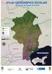
Thiago Broerman Cazes Interpretação Baseada ... - NIMA - PUC-Rio
Thiago Broerman Cazes Interpretação Baseada ... - NIMA - PUC-Rio
Thiago Broerman Cazes Interpretação Baseada ... - NIMA - PUC-Rio

You also want an ePaper? Increase the reach of your titles
YUMPU automatically turns print PDFs into web optimized ePapers that Google loves.
92<br />
40 SHACKLFORD, A.K.; DAVIS, C.H. A Hierarchical FUZZY Classification<br />
Approach for High-Resolution Multispectral Data Over Urban Areas, IEEE<br />
Transactions on Geosciences and Remote Sensing, v. 41, p.2354-2363, Sept.<br />
2003.<br />
41 MELGANI, F.; Al HASHEMY, B.A.R.; TAHA, S.M.R. An explicit FUZZY<br />
supervised classification method for multispectral remote sensing images, IEEE<br />
Transactions on Geosciences and Remote Sensing, v. 38, p.287-295, Jan. 2000.<br />
42 SHACKLFORD, A.K., DAVIS, C.H. A fuzzy classification approach for highresolution<br />
multispectral data over urban areas, In: IGARSS 2002 - International<br />
Geoscience And Remote Sensing Symposium, Toronto, ON, Canada, June 24-28,<br />
2002. Proceedings of IGARSS 2002, v. 2, p. 1621-1623, Jun. 2002.<br />
43 BINAGHI, E.; GALLO, I.; PEPE, M. A cognitive Pyramid for Contextual<br />
Classification of Remote Sensing Images, IEEE Transactions on Geosciences<br />
and Remote Sensing, v. 41, p.2906-2922, Dec. 2003.<br />
44 SUGUMARAN, R.; PAVULURI, M.K. The Use of High-Resolution Imagery for<br />
Identification of Urban Climax Forest Species Using Traditional and Rule-Based<br />
Classification Approach, IEEE Transactions on Geosciences and Remote<br />
Sensing, v. 41, p.1933-1939, Sept. 2003.<br />
45 SHISONG Y.; CHIH-CHENG, H. Texture classification in remotely sensed images,<br />
In: IEEE Southeast Conference. 5 – 7 April 2002, Columbia, SC. Proceedings of<br />
IEEE Southeast p. 62 – 66, Apr. 2002.<br />
46 LELONG, C.C.D.; THONG-CHANE, A. Application of textural analysis on very<br />
high resolution panchromatic images to map coffee orchards in Uganda, In:<br />
IGARSS 2003 - International Geoscience And Remote Sensing Symposium, July<br />
21-25 2003. Proceedings of IGARSS 2003, v. 2, p. 1007 – 1009, 2003.<br />
47 PESARESI, M. Textural classification of very high-resolution satellite imagery:<br />
Empirical estimation of the interaction between window size and detection<br />
accuracy in urban environment, In: ICIP99 - International Conference on Image<br />
Processing, Kobe, 24-28 Oct. 1999. Proceedings of ICIP99, Kobe , v. 1, p. 114 –<br />
118, Oct. 1999.tober 1999, Vol.1, 25AP3.3, pp.114-118<br />
48 BENEDIKTSSON, J.A.; SWAIN, P.H.; ERSOY, O.K. Neural Network Approaches<br />
Versus Statistical Methods In Classification Of Multisource Remote Sensing data.<br />
IEEE Transactions on Geosciences and Remote Sensing, v. 28 , n. 4 , p. 540 –<br />
552, jul. 2003.<br />
49 HERRIES, G.M.; SELIGE, T.M. Characterization of agricultural land using signal<br />
processing and cognitive learning techniques. In: IGARSS 1997 - International<br />
Geoscience And Remote Sensing Symposium, Toronto, ON, Canada, August 3-8,<br />
1997. Proceedings of IGARSS 1997, v. 2, p. 1032 – 1034, Ago. 1997.<br />
50 BENEDIKSSON, J.A.; SVENSSON, J.R.; AMASON, K. Classification and feature<br />
extraction of AVIRIS data. IEEE Transactions on Geosciences and Remote<br />
Sensing, v. 33 , n. 5 , p. 1194 – 1205, Sept. 1995.<br />
51 LEE, C.; LANDGREBE, D.A. Feature extraction based on decision boundaries.<br />
IEEE Transactions on Pattern Analysis and Machine Intelligence, v. 15, n. 4 ,<br />
pp. 388 – 400, Apr. 1993.